Saturday, September 5, 2020

Rowley Shoals: The bleached Australian reef and a Covid challenge


Coral bleaching was detected in a usually healthy reef off Australia's north-western coast earlier this year.
But due to Covid lockdown rules, the discovery presented scientists with a challenge: how could they survey the reef without being able to travel there?
Video by Isabelle Rodd

 Rowley Shoals in the North West of Australia (AHS nautical charts with the GeoGarage platform)
 
Links :

Friday, September 4, 2020

How low can satellites go? Air Force bets Very Low Earth Orbit will give it more capabilities


Earth Observant's conceptual overview of its VELO "Stingray" imaging satellite constellation.

From Forbes by Eric Tegler

Earlier this month, a small San Francisco-based startup called Earth Observant announced it had won a development contract with the Air Force’s AFWERX technology incubator to advance its design for a small, very low Earth orbit (VLEO) optical imaging satellite.

Another small satellite development contract might not seem like a big deal given the many smallsats now in production (and in space) for communications, data and imaging purposes.
But Earth Observant’s development contract may signal a new trend: sending small satellites up to relatively low altitudes.

Satellites which fly in low Earth orbit (LEO) typically ascend to an altitude of 500 kilometers (310 miles) or higher above earth.
VLEO sats like Earth Observant’s proposed “Stingray” imaging satellite fly at 300 km or less.
At 250 km where the startup says Stingray will fly, satellites are still basically in Earth’s atmosphere.
That comes with some downsides like aerodynamic drag and strong gravitational pull, which are significant enough to make a spacecraft’s orbit decay in less than 5 years, requiring changes in traditional designs.

But there are also real advantages.
Flying at lower altitude can improve the resolution of optical sensors, radiometric performance (infrared/microwave sensors) and geospatial accuracy.
Those sensing benefits can also reduce required payload size (optical, radar or communications) and thus cost.

VLEO Earth-observing satellites could be more competitive, either by flying more capable platforms at the same cost, or by offering the same capabilities at a reduced cost.
One could argue that lower costs, allowing for greater numbers, also yield better coverage.

And there’s another issue.
Low-Earth orbit is increasingly crowded.

Estimates suggest that by 2025, the number of man-made objects sent into space annually will surpass 1,100.
Most will be stationed in LEO.
SpaceX offers a prime example: It has launched over 600 LEO satellites for its Starlink broadband internet constellation and plans to launch thousands.

The Starlink team is building 120 smallsats each month and the Federal Communications Commission has approved SpaceX’s scheme to build out the Starlink constellation to 12,000 satellites.
The company has applied for rights to add 30,000 more.

Amazon and U.K.-based OneWeb are building their own internet constellations in LEO that are planned to have 3,236 and 1,000 satellites, respectively.
The resulting clutter could not only have implications for collisions in LEO but for density that might interfere with the sensing capabilities of very important military and strategic satellites at higher altitudes.

Low Flying Fish

Earth Observant’s Stingray is a 400-pound, 8-foot by 8-foot optical imaging satellite with a Space Shuttle-like body, or “bus,” as it’s called in the industry.
The shape helps reduce aerodynamic drag at the altitude at which Stingray will fly.
It may also aid maneuverability for other purposes though we didn’t discuss it with Earth Observant.


Earth Observant's Stingray satellite with its Space Shuttle-shaped "bus" or body.
The wing-like ...
[+] EARTH OBSERVANT

The privately held startup is comprised of veterans of the satellite industry with expertise in propulsion systems.
They began designing Stingray in 2018 and hope to have a prototype aloft within the next 24 months, ultimately leading to a 30-unit constellation that can provide highly accurate, timely imagery to military, government and civilian customers.

“What I think intrigued the Air Force is the fact that we [proposed] operating in a very low-Earth orbit and that we could potentially produce [satellites] very quickly, rather inexpensively and get a number up in space,” says Earth Observant co-founder and COO Paul E. Smith.

Timeliness was another factor that appealed to AFWERX, the USAF’s Space and Missile Systems Center and the Air Force Research Laboratory, according to Smith.
The VLEO Stingray could send near real-time imagery to Air Force or Army users.
In satellite imaging terms, near real-time means transferring a partially processed image to a fixed ground station or mobile user within a few minutes.

That’s shorter than average partly due to the marginally lower latency that comes with low altitude transmissions, but also due to Earth Observant’s goal of carrying out some image processing (raw optical image data needs to be processed and formatted for use) onboard Stingray using edge computing methods rather than simply sending raw data to a ground station.

“Our goal is to have [the imagery data] skip the traditional ground station processing stacks,” Smith affirms.
“We knew it was important, we didn’t know how important.
But after talking to the Air Force and Army it became pretty clear that getting the data faster is their fundamental desire.
It’s something they’re looking for all of us out there in space to do.”

Stingray will send imagery via Ka band (26.5 to 40 GHz) which fits into the multi-domain sensor linking TITAN (Tactical Intelligence Targeting Access Node) and AMBS (Airborne Battle Management System) systems that the Army and Air Force are respectively developing.
Its potential to cut out the middleman (i.e.
ground processing stations), relaying imagery directly to tactical units/assets would surely be of interest to the services and is something that EA’s Smith hopes the Air Force will test Stingray on.

“Can we produce a viable product right off the satellite, transfer to the ground and have degrees of usability?”

Full image processing and analytics (for which the Air Force has many tools Smith points out) can still be done with Stingray’s optical data but images for mobile users in tactical environments need not always be perfect.
Timeliness matters.

“The idea is that if you got an image of an area within five minutes, whatever you were interested in might still be there,” Smith says.


Seeing but not being seen in VLEO

Colonel Eric Felt, director of the Air Force Research Laboratory Space Vehicles Directorate at Kirtland Air Force Base in New Mexico, says he’s an advocate of using all kinds of orbits, not just the traditional ones for imagery and communication
“I see VLEO as a new orbit that has potential for us. I’m really glad that [Earth Observant] is going after this mission area.”

Colonel Felt agrees that the resolution which satellites flying closer to Earth can deliver for smaller payload is desirable.
It yields a cost per high-res image advantage that the Air Force is eager to leverage, he says.
“More satellites and more capacity is definitely of interest to us.”

“The other thing I really like about VLEO is that it’s harder to track satellites in that orbit.
First, they zoom overhead so fast. The angular velocity makes it difficult to track a satellite coming over you.
Second, the resistance from the atmosphere makes it more difficult to predict where a given satellite is going to be at a certain point. We like that too.”

Felt also acknowledges that LEO is a busy place.
“If LEO becomes crowded, why not go higher or lower? You have more freedom of operation in VLEO.”

Earth Observant’s proposed onboard image processing and edge computing is not unique to the company or to VLEO flight levels but it is of high interest to Air Force combatant commanders Col.
Felt confirms.

In fact, the Air Force recently carried out an exercise in which it acquired all the available commercial satellite imagery it could find, taking data from 266 satellites.
It then asked warfighters if the imagery was useful.
The answer was a strong “yes,” citing the particular value of persistent imaging.
Commanders also acknowledged that current timelines for processing and image delivery are too long.

“They just can’t wait hours to get their imagery,” Felt says.

Looking at the artwork above, you may note that Earth Observant stresses Stingray is capable of adjusting in-orbit altitude, has low cross-sectional area and is highly maneuverable.

Such attributes could be useful to the Air Force.

“The more you can maneuver, the less predictable your orbit is.
That’s good,” Felt says.
“A small cross-section is good too.
If they can’t find you, they can’t tell that you’re [flying] overhead.
If you really get into a shooting war, it’s harder for them to attack you or otherwise defeat you.”

The military appears to be going for agile, low-altitude satellites at low cost.
That’s perfect competitive space for fledgling satellite service providers.

Links :

Thursday, September 3, 2020

Ships in troubled waters: Predicting the spread of oil spills


From Medium by CMCC

From Beirut, Lebanon, to Mauritius the sea is crossed by ships carrying materials that, if released into the ocean, are a menace for human beings and the marine environment. Satellites, data, and advanced modelling can help deal with these potential disasters. Scientific research and innovation are critical to predicting the movement and pervasiveness of oil spills and can direct cleanup efforts in a timely manner.

The bulk carrier, MV Wakashio, a 984-foot-long vessel sailing from China to Brazil ran aground off the southern coast of the island of Mauritius, near Pointe d’Esny, on 25 July 2020.
The Japanese owned ship, sailing under a Panamanian flag of convenience, has since become the focus of international attention as a potential 4,000 tonnes of fuel and 200 tonnes of diesel were at risk of tainting the pristine blue waters of this tropical paradise with an ineffaceable black smudge.
Yet another instance of marine shipping leading to oil spills.

In this image, captured on 11 August by the Copernicus Sentinel-2 mission, the MV Wakashio, visible in the bottom of the image, is stranded close to Pointe d’Esny, an important wetland area.
The oil slick can be seen as a thin, black line surrounded by the bright turquoise colours of the Indian Ocean.
Oil is visible near the boat, as well as other locations around the lagoon.
Source: ESA

Mauritian Government representatives have scrambled to contain the spill and called for international support.
“This is the first time that we are faced with a catastrophe of this kind and we are insufficiently equipped to handle this problem,” explains Sudheer Maudhoo, Minister of Blue Economy, Marine Resources, Fisheries and Shipping. Similarly the environment minister, Kavydass Ramano, also stressed the risk of an unprecedented environmental crisis and the dire consequences that the spill could wreak on the island nation’s tourism and food security.

The Mauritian Prime Minister, Pravind Jugnauth, was forced to call a state of emergency and appeal for international help in dealing with the crisis.
This led to France and Japan sending aid teams and the ship’s operator, Mitsui OSK Lines, and local volunteers placing containment booms around the Wakashio to hold back the spread of oil. By 13 August, 3,000 tonnes of fuel were offloaded from the Wakashio successfully just days before the ship split in two.
Local authorities and those responsible for the collision are now left with the arduous task of dealing with over 1,000 tonnes of fuel that have spilt into the surrounding ocean, and the ship’s carcass.

Simulating the weathering and transport of the Mauritius oil spill

“An important part of dealing with the oil spill is understanding where it will move to” explains Giovanni Coppini, Director of Ocean Predictions and Applications division at CMCC and an expert in oil spill emergency management at sea and development of environmental and climate change ocean indicators.
Using operational oceanography observations, modelling products and climate re-analyses his team has produced one of the first simulations of how the Wakashio spill will spread.
“We use Copernicus Marine Service current forecasts and wind forecasts by the ECMWF, using these two ‘forcings’ to simulate the weathering and transport of oil at sea, after which we apply them to our own CMCC Global Oil Spill fate and Transport model to generate predictions” he explains
 “We are looking to demonstrate the European Copernicus Marine Environment Monitoring Service’s ability to provide sea current forecasting models that can be used to forecast oil spills on a global scale.”

This is not the first time that Coppini and the CMCC team have been involved in responding to marine environmental emergencies.
He was previously head of a JCOMM Expert Team on Marine Environmental Emergencies Response (ETMEER) that sought to develop best practices and coordination in the field.
Moreover, the CMCC team has provided oil spill forecasting, in collaboration with MONGOOS partners and REMPEC, in many other cases in the Mediterranean Sea including in mapping the oil spill caused by the collision between the Ro-Ro ship Ulysse and CSL Virginia on 7th October 2018 off the coast of Corsica.

On 21 August the forecast Bulletin on the Wakashio oil spill accident was published: “The oil spill trajectory and fate were simulated using the MEDSLIK-II oil spill model coupled with Copernicus Marine Service (CMEMS) oceanographic and ECMWF meteorological products.”
However, due to the complexity of the spill scenario, which involves a reef and currents that are not covered by CMEMS Global currents fields, only wind forcing was used whereas simulations for areas outside the reef lagoon included current forcings.
Comparing the forecast simulation reproducing the spill from 10–16 August against satellite imagery revealed that the MEDSLIK-II simulations were reasonable.
Furthermore, the forecast is that the spill will remain as previously simulated and hence “close to the southern coastline of the embayment and in the Blue Bay.”
The largest uncertainties about its development stem from fields inside the embayment and the spill rate from the Wakashio shipwreck.

Meteo France has also developed an initial model simulating the dispersion of oil in Mauritius based on their forecasting systems.
However, “by drawing on our access to satellite images provided by Sentinel 1 and 2 (which are also part of Copernicus),
MEDSLIK-II is the first to see how accurate these simulations are”, explains Coppini.

More shipping spills on the horizon

Unfortunately, the Wakashio is just one in a long history of marine oil spills.
One of the first cases to grab significant attention involved the Liberian tanker Torrey Canyon.
On 18 March 1967, the tanker struck rocks off the coast of Cornwall, England, pouring 120,000 tonnes of crude oil into the ocean and acting as a true wakeup call for the international community. In 2019 alone there are believed to have been at least 6 significant oil spills (7 tonnes or more) from shipping.
On a positive note, the average number of significant spills per year in the 1970s was about 79, meaning that there has been almost a 90% decrease in these kinds of incidents.

However, as the recent example in Mauritius indicates, complacency is not an option.
Furthermore, instances such as that of the compromised oil supertanker, the FSO Safer, off the coast of Yemen require urgent attention.
The Safer has also been in the spotlight as it is at risk of spilling a million barrels of crude oil into the sea.
This would amount to four times the amount of crude spilt in the Exxon Valdez disaster of 1989 and hence become one of the largest oil spills in human history.
The UN reports that seawater is already seeping into the Safer and that if access to the tanker off the Yemen coast is not granted we could be faced with catastrophic consequences.

The Safer, built in Japan in the 1970s and now owned by the Yemeni government, has received no maintenance since 2015 when the Shiite Houthis succeeded in taking over the government in Sanaa.
The ship has since become a pawn in a geopolitical conflict that sees the Houthi rebels resisting Saudi-led military intervention in Yemen.
The tanker’s precarious situation is now facing increased scrutiny as people draw parallels with the recent explosion in Beirut, where tonnes of ammonium nitrate were left in unsafe storage due to issues with a shipping vessel, political turmoil and the government’s inability to address an impending crisis.

“Time is running out for us to act in a coordinated manner to prevent a looming environmental, economic and humanitarian catastrophe,” explains Inger Andersen, Under-Secretary-General and Executive Director of the United Nations Environment Programme, further elaborating that access needs to be granted to the Safer to assess its condition and determine how its cargo can be safely off-loaded.
Yemen’s information minister, Moammar al-Eryani, also warns that there could be a “human, economic and environmental catastrophe” if the Safer sinks or explodes.

The economic and environmental implications of marine shipping oil spills

Already, the question of who will pay for the Wakashio oil spill is surfacing.
Typically ship owners are the ones to foot the bill and in this case the owners of the ship are Nagashiki Shipping, who are expected to bear the liability for damages.
Although the shipping company has not declared how much it expects the clean-up to cost there are precedents.
In 1997 a Russian-flagged tanker sank in the sea of Japan, releasing over 6,000 tonnes of oil and eventually agreeing to pay damages up to 26.1 billion yen (246 million USD at current rates).
According to Michio Aoki, an attorney specialising in marine accidents, payments will likely be capped at 2 billion to 7 billion yen for a ship of the Wakashio’s size, under a 1976 convention on liability for maritime claims, reports Nikkei Asian Review.

Aside from the economic reparations, there is also the irreversible damage that can be done to local biodiversity.
“Thousands of species around the pristine lagoons … are at risk of drowning in a sea of pollution, with dire consequences for Mauritius’ economy, food security and health,” denounces Happy Khambule, senior climate and energy campaign manager at Greenpeace Africa.
How pervasive the consequences of the Wakashio spill in Mauritius will be is yet to be seen.
According to a 2010 study, the effects of oil spills change according to a variety of factors including: “the physico-chemical parameters of the oil, the characteristics of the environment affected, and the physical, chemical, and biological processes occurring there, such as evaporation, dissolution, dispersion, emulsification, photo-oxidation, biodegradation, and sedimentation.”
For example, black and sticky fuels are usually less toxic than light oils such as diesel but at the same time are harder to breakdown, last longer and smother life in the sea and on the coasts.

However, it goes without saying that oil spills pose a significant danger to fauna and flora and cause damage to marine and land ecosystems, as well as local livelihoods, which are already under increasing pressure due to climate change .
Petroleum-related chemicals that are spilt are toxic, often carcinogenic or can be bioaccumulated in the tissues of marine organisms.
Although these kinds of incidents should be avoided before they happen, science can offer a valuable tool for predicting the movement and pervasiveness of these spills and thus help contain the worst of their effects after they happen.

Read the complete CMCC MEDSLIK-II oil spill bulletin here.

Links:

Wednesday, September 2, 2020

Turkey-Greece tensions: eastern Mediterranean claims in maps


From TRTWorld

What would the east Mediterranean’s ‘borders’ look like from the perspective of both countries?

As Turkey and Greece are at loggerheads in the eastern Mediterranean, maps staking out the claims of both nations have become widely available.


Turkey, for its part, has sought to point out that Greek claims in the region would be tantamount to hemming in the country by giving disproportionate territory to Greece.
As a peninsula state, Turkey has more than 8,333 kilometres of coastline and the country has more than 462,000 square kilometres of potential maritime jurisdictional area.

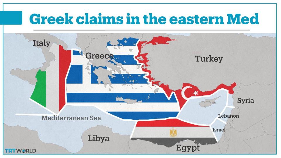
If Turkey did not assert its claim in the eastern Med, this is what Greeces EEZ would look like.
Turkey has described this as illegitimate.
(TRTWorld)

Greece argues that its islands in the Aegean sea can generate their own Exclusive Economic Zones (EEZ) which would allow Greece to explore 200 nautical miles of sea water.

Turkey has argued that islands can not generate their own EEZs and that Greece’s EEZ should start from the mainland, rather than from the sprawl of hundreds of islands.

As the map above shows, Turkey - which has a significant coastline - would be denied any rights to waters just mere kilometres away from the mainland.
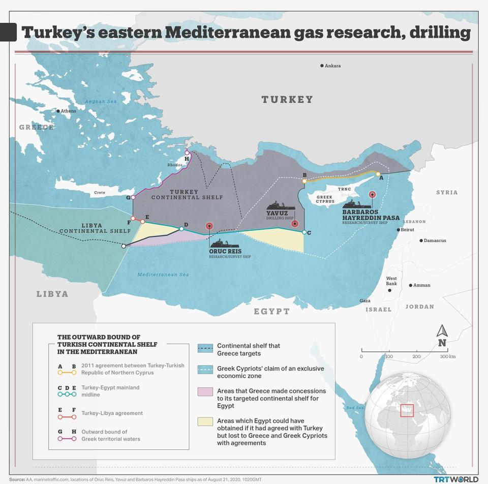
Turkey (grey) in an agreement with Libya (green) in 2019 agreed on a maritime border which Ankara argued was a fair and equitable.
(TRTWorld)

The Exclusive Economic Zones are governed by the United Nations Convention on the Law of the Sea (UNCLOS) which was signed in 1982.
Turkey has never signed the Treaty, although it has used certain principles from it to settle all maritime claims with the Black Sea states.
The US, Peru and Columbia are a handful of countries that have also not ratified UNCLOS agreement.

Last year, on November 27, when Turkey and Libya signed a maritime agreement which established the EEZ of both countries, principles from UNCLOS were used.

The above map is Turkey’s EEZ.
The country says it fairly reflects its geographic position and legal maritime claims.

Turkey has urged Greece to resolve the issue bilaterally considering the proximity of each other's borders and that both countries are NATO allies.

Just when it seemed Germany had brought both sides together earlier this month, Greece and Egypt signed an overlapping maritime agreement on the eve of talks with Turkey.

 
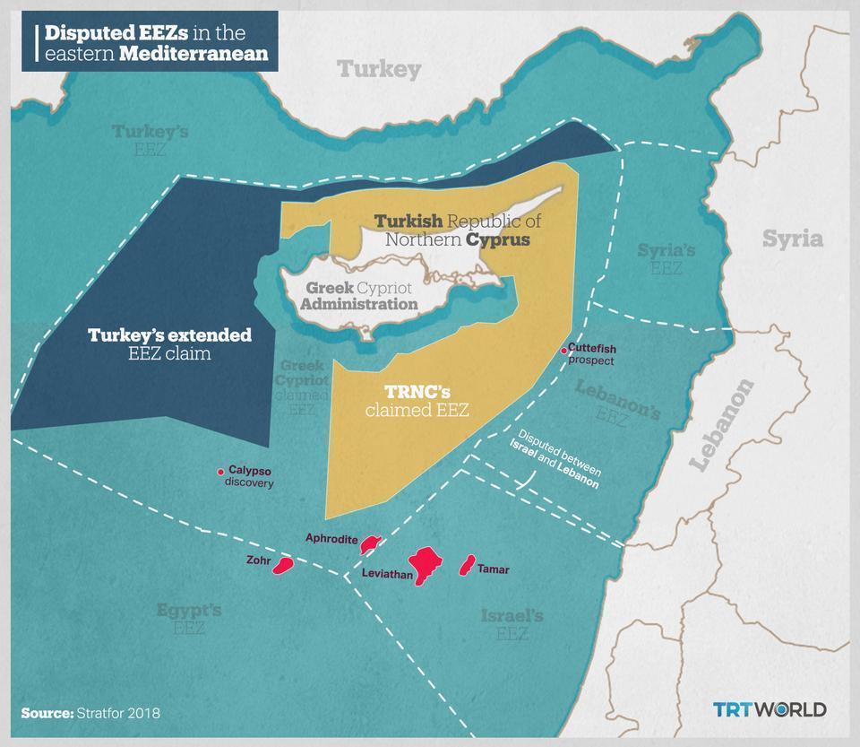
Turkey's EEZ (blue) and the Turkish Republic of Northern Cyprus EEZ (yellow).
(TRTWorld)

Turkey called off bilateral talks, citing a lack of commitment from the Greeks to engage in negotiations without preconditions.

In an interview, Cem Gurdeniz, a retired Turkish admiral said: “Greece and the Greek Cypriot Administration thought it could carve out 150,000 square kilometres of the sea from Turkey.
They thought that the Turks are land people not sea faring people and that the EU and the US would force Turkey to accept it. No, we will not permit such a thing.”

Many observers have suggested that competition for resources has been the main driving force in the eastern Mediterranean.

 
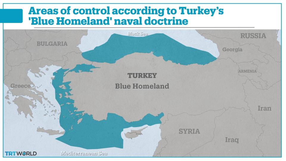
Turkey's Blue Homeland strategy as conceptualised by Cem Gurdeniz.
(TRTWorld)

Turkey, however, has adopted a defensive naval doctrine called the ‘Blue Homeland’.
It effectively secures its main and only outlet to the sea freely, which is why the eastern Mediterranean is so important for Turkey’s political and military establishment.

The Blue Homeland doctrine was initially proposed in 2006, it was adopted as official policy in 2013 by the Turkish government.

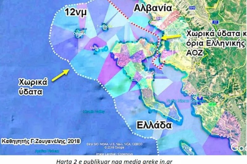
Map of the territorial waters in Aegean
 
While the EEZ is governed by the UNCLOS, and therefore allows trading ships to pass freely, the passage of military naval ships is highly contested and Turkey does not feel strategically comfortable or willing to outsource permission to what it sees as the whims of the Greek state who it would have to seek permission from.

The Blue Homeland doctrine, therefore, aims to ensure that Turkey can defend its own borders without relying on other states.

Links :

Tuesday, September 1, 2020

‘Going Dark’ is so 2019


From Windward by Omer Primor

Movies have taught us that, when looking to achieve an investigative breakthrough and capture a bad-guy, it is necessary to track their phones.
Movies have also taught us that the bad guys know that, and they often adapt their ways, trying to throw the good-guys off their tail.

The ocean is no different than a great spy movie.

For over two decades, the shipping industry relied on AIS to prevent collisions at sea by requiring ships larger than 300 tons to transmit their digital information, ensuring ships maintain a safe distance from one another at sea.
Today, AIS data can do more.

AIS transmissions implement a new level of transparency regarding ship movements in the ocean and can be used to optimize, enhance, and improve maritime trade, transportation, security, safety, and supply chain management.

For the good guys, this is great news, but for the bad guys, this is another problem they must overcome; AIS transmissions and the increased transparency they create is precisely what bad actors at sea want to avoid.
To try and exploit the sea and conduct illicit activities, criminals have developed sophisticated ways to exploit AIS vulnerabilities and mask their location.

In 2020 however, that may be a moot effort.

AIS off, pressure on

Criminals trying to trade illegal goods or violate sanctions need to do so without getting caught.
As sea, that means avoiding detection, hiding origin and destination locations, not docking at ports, and doing anything possible to avoid transmitting AIS data.

When docking, transhipping, or getting too close to a ship becomes unavoidable for the criminals, their only option is to go dark.
By turning off transmissions, there are no records of locations, port entries, or transshipment conduct occurring.
Sounds great? Think again.

The bar for sanctions screening has been raised as a result of the new advisories, and with it, the Know Your Vessel (KYV) checks companies must perform.
For criminals looking to violate sanctions or conduct illegal activities under the guise of “going dark,” this means bad news.

Any AIS transmission gap becomes a blaring red flag necessitating further examination, thereby increasing the chance of exposure.

It no longer matters if there is no proof of loading or discharging sanctioned cargo; the suspicious behavior itself is enough for companies to withhold services or terminate contracts under the new advisory.

Having an AIS transmission gap and not knowing a ship’s exact whereabouts becomes reason enough to flag it, making turning AIS off completely counterproductive.

You see what I want you to see

Criminals recognize that turning off their AIS signal is an immediate red flag, and that is what they want to avoid.
Instead of turning off AIS data transmission, they instead try to manipulate the data.
Instead of controlling WHEN they do and do not transmit data, they try to control WHAT data they transmit, and WHO is transmitting it.

Consider the following case:
In mid-June 2020, a laden VLCC tanker docked in Qingdao, China.
Based on its size and reported draft change, it delivered approximately 2 million barrels of crude oil from the Persian Gulf.
Diving deep into the voyage data reveals that the tanker first arrived at the Gulf late-April, and after a quick detour into Hormuz, it anchored halfway between Fujairah and Iran for 10 days.
After anchoring, the ship reported its draft as “laden,” and set sail for China.


The voyage itself seems similar to many others; however, there is one significant unanswered question: Where did the oil come from?

An examination of the ships’ AIS data did not reveal any port calls, transshipments, or “dark” periods during the entire 10 days it was anchored.
However, during this time, oil was loaded to the ship.
This makes the origin of the cargo a mystery.

When examining this trade contextually, things do not add up.
Behavior analysis shows the tanker loaded a high-risk commodity in a high-risk area while taking significant efforts to disguise the origin of the goods.
This fact alone does not prove that the ship engaged in a sanctionable and illegal trade, but it should be cause for concern and trigger a due diligence process to investigate the situation further.


Here is the full story of what happened with this tanker: shortly after anchoring offshore Iran, tanker A stopped transmitting AIS.
At the exact same time, another tanker anchoring nearby (tanker B) began transmitting under the guise of tanker A.
In doing so, AIS transmission was manipulated to carry the same identity as tanker A, making it appear as though tanker A was transmitting continuously, albeit with a slightly changed location.
In reality, tanker A was not transmitting AIS data at all.
During this time, tanker A went dark, sailed to Iran, and loaded the sanctionable cargo of crude via ship-to-ship from an Iranian tanker.

Several days later, after tanker A was laden with sanctioned oil, it returned to the same area where tanker B was.
In a magnificently orchestrated digital dance, tanker B switched off, tanker A switched on, and the operation was complete; a VLCC, laden with Iranian crude, retained squeaky clean from entity and AIS screenings.
The only way this could have, and was, detected, is by examining voyage irregularities.

Behavior analysis to the rescue

Since the start of 2020, the number of VLCCs “going dark” to disguise sanctionable trading has dropped by over 80%, going down from 26 tankers in January to just 4 in July.

The decline in VLCC’s “going dark” can either mean a drop in the trade of sanctioned crude or an increase in the sophistication of deceptive shipping practices criminals undertake.


“Going dark” is still a key deceptive shipping practice used by bad actors looking to conceal illicit operations, but now it is harder to identify it.
As seen above, criminals are getting better at manipulating AIS data, and each time technology catches up with them, they will have a new method of AIS manipulation.

Unfortunately for criminals, while they can try to manipulate AIS data and show false movements and identities, they cannot manipulate behavior.
Analyzing trade patterns of all ships makes it possible to whitelist certain vessels and immediately reveal voyage irregularities for those that do not operate the way they should.

Behavioral analysis that leads to actionable results can only be achieved by combining automated analysis with human expertise.
Together, man and machine can investigate new signals and voyage irregularities, improving accuracy and illicit behavior at sea.
Incorporating emerging methods that go beyond common deceptive practices is crucial for businesses and organizations that want to make forward-looking decisions and gain control of potential risks before they impact their operations.

Much like in the movies, criminals do not simply stop exploiting opportunities; they just get better at hiding.
It’s up to the good guys to stay one step ahead of crime at all times.

Links :

Monday, August 31, 2020

New Zealander sails through Arctic on custom yacht in violation of COVID-19 restrictions

The Kiwi Roa off the coast of Greenland in 2019.
Peter Smith, 72, is sailing this yacht in the Northwest Passage in violation of COVID-19-related orders prohibiting most foreign ships from entering Canadian waters.

From CBC by John Last


'I am a yacht, not a bloody cruise ship,' says Peter Smith, who's adamant he will not be turned around

According to the Canadian government, he has no business being there.

But 72-year-old Peter Smith is sailing the Northwest Passage anyway, in violation of COVID-19-related orders prohibiting most foreign yachts from entering Canadian waters.

Since June 1, Transport Canada has prohibited pleasure craft from operating in Arctic waters "to better protect Arctic communities" from the spread of COVID-19.

But according to a Facebook post on Aug. 20, Bobby Klengenberg, a local observer with the Inuit Marine Monitoring Program, spotted Smith's custom yacht, the Kiwi Roa, off the coast of Cambridge Bay, Nunavut.

Transport Canada confirmed the sighting in an email to CBC News, and said the vessel was told "to depart Canadian waters and not make landfall."

A spokesperson said the Canadian Coast Guard will "monitor the vessel's transit out of the region." If Smith is indeed found to have broken the law, they wrote, the agency "will not hesitate to take appropriate enforcement action," including penalties of up to $5,000.

CBC News contacted Cambridge Bay's mayor, its chief administrative officer and representatives of the local Hunters and Trappers Organization. None responded to requests for comment.

Bureaucracy 'gone mad': yachter

Smith is an accomplished boat builder and ocean racer from New Zealand. He has been living aboard the custom-built Kiwi Roa, described on his website as "the ultimate ocean-going home," for 26 years.

Reached by email, Smith said the story is one of bureaucracy "out of control and gone mad."

"I suspect it is also motivated toward gaining political points in support of Canada's claim to have control of the [Northwest Passage], the local Inuit and innocent yachtsman just being pawns in the game," he wrote.

Smith aboard the Kiwi Roa. Reached by email, Smith said completing a transit of the Northwest Passage is 'unfinished business' after he failed a similar attempt in 2018. (PeterSmith.net.nz)

In a second email, Smith said the wording of the original Transport Canada ban was "ambiguous."

The text of the ban does allow for foreign vessels to exercise the right of "innocent passage" in Canadian waters, which Smith says he is now relying on "as a last resort."

But Canada's official position is that the Northwest Passage counts as "internal waters," meaning that right does not apply. That position is contested by the United States and several other countries.

"Canada has no legal right to apply Canadian law to a foreigner in [an] international waterway," Smith wrote.
"Half the world does not recognize Canada's claims and this needs to be sorted out."

Smith said he was initially communicating with Transport Canada after they first gave notice of the ban on May 14.

He said it wasn't until six days after he left Nome, Alaska, on July 27 that they notified him the trip would not be allowed.

In response, he stopped reporting his location to authorities.

"I had tried to comply with Canadian requirements as a mark of respect to Canada," he wrote. "As far as I am concerned, I was dictated to and not consulted."

Smith said he never intended to stop "at any place of habitation." Since he was spotted, he has also agreed with Transport Canada to provide daily position reports — though only once a day, not twice as Transport Canada requested.

"I am a yacht, not a bloody cruise ship," he wrote.


The Kiwi Roa at its launch in England in 1994. Smith estimated he is two to three weeks away from exiting the Lancaster Sound, at which point he will be back in international waters. (PeterSmith.net.nz)

Smith went on to say concerns about his spreading the coronavirus are overblown.

"I am 72 [years] old with a history of lung problems from my job as boat builder," he wrote.
"I am much more at risk from the villages than they are from me."
"I respect the locals wish to be left alone. I am not a tourist."

'Record' trip underway

Smith's previous travels have taken him to Antarctica, South Africa, Greenland, and Newfoundland, among other places.

In his email, he said his final destination on this journey is Lisbon, Portugal, which he estimated is about eight weeks away.
They would need a swat team to make me [turn around.]- Peter Smith, captain of the Kiwi Roa

The trip via the Northwest Passage is more than 9,000 kilometres shorter than the alternative route via the Panama Canal, he said.

But Smith also said completing a transit of the Northwest Passage is "unfinished business" after he failed a similar attempt in 2018.

He claimed he is on track to set a record for the fastest transit of the Northwest Passage with no fuel stops, having sailed "90 per cent of the way."

Smith estimated he is two to three weeks away from exiting the Lancaster Sound, at which point he will be back in international waters. He is adamant he will not be turned around.

"They would need a swat team to make me do that," he wrote.

Links :

Sunday, August 30, 2020

Map of the week : The Explorers

Map by @NatGeo shows the routes that famous explorers took around the world
(click on the picture to view it and expand it)

 World saling ship routes:
this chart illustrates the more important routes described in the book of "Ocean Passages" published by the Admiralty in 1923