A team of NYU scientists has captured on video a four-mile iceberg breaking away from a glacier in eastern Greenland.
This phenomenon, known as "calving", is a force behind the rise of global sea water levels.
“Global sea-level rise is both undeniable and consequential,” observes David Holland, a professor at NYU’s Courant Institute of Mathematics and NYU Abu Dhabi, who led the research team.
“By capturing how it unfolds, we can see, first-hand, its breath-taking significance.”
Holland’s research team has studied the waters off the coast of Greenland for more than a decade by measuring subtle changes in water temperature and wave formation.
Video Credit: Denise Holland, Logistics Coordinator/NYU’s Environmental Fluid Dynamics Laboratory (Video shot June 22, 2018- Real time length: 30 minutes)
Helheim glacier DGA nautical chart with the GeoGarage platform
ESA’s Aeolus mission scientist, Anne Grete Straume explains how winds are generated, how they affect our weather, and how Aeolus will measure the wind and how this information will be used to improve weather forecasts and climate models.
A new analysis of how air moves between two layers of Earth’s atmosphere reveals a deep system that could enable long-term weather forecasts and better climate models.
If you can predict the path of the jet stream, the upper atmosphere’s undulating river of wind, then you can predict weather – not just for a week or two, but for an entire season.
A new Stanford study moves toward that level of foresight by revealing a physical link between the speed and location of the jet stream and the strength of the polar vortex, a swirl of air that usually hovers over the Arctic.
“The jet stream sets everything,” said Aditi Sheshadri, lead author and assistant professor of Earth System Science in the School of Earth, Energy, & Environmental Sciences (Stanford Earth).
“Storms ride along it.
They interact with it.
If the jet stream shifts, the place where the storms are strongest will also shift.”
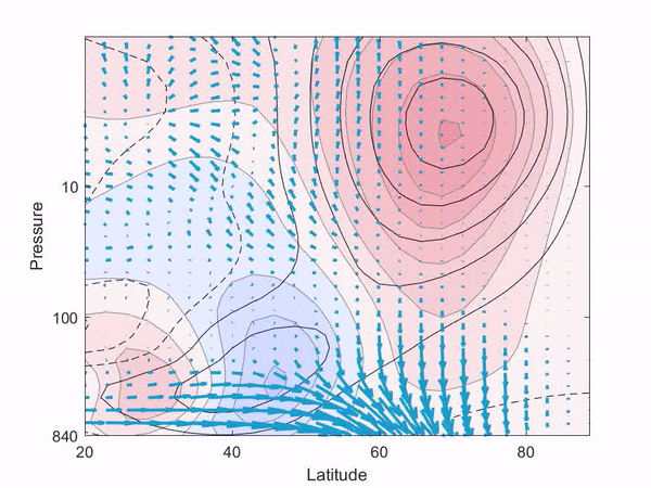
The research, published in the Journal of Atmospheric Sciences, identifies two distinct modes in how air flows within the jet stream and the layers of atmosphere that sandwich it.
Alex (IK MetOffice) explains the Polar Vortex.
The atmosphere’s deep system
In one mode, changes in wind speed and direction start close to the equator in the troposphere, the wet, stormy layer of atmosphere below the jet stream and closest to Earth’s surface.
Shifts of wind in this mode quickly propagate up through the jet stream and into the polar vortex in the dry, upper layer of atmosphere known as the stratosphere.
In the other mode, the strength of the stratosphere’s polar vortex influences the path and strength of the jet stream – and how it interacts with storms in the troposphere.
In this mode, the polar vortex sends a signal all the way down to the surface like a pulse.
A weaker vortex produces a weak jet stream that slips toward the equator; a stronger vortex intensifies the jet stream while drawing it poleward.
“These deep vertical structures haven’t been shown before,” Sheshadri said.
“It’s something fundamental about the system itself.” Her analysis could help explain the surface weather impacts of an event that occurred in early 2018, when the vortex weakened so much that it ripped in two – a phenomenon that scientists know can blast up to two months of extreme weather into western Europe.
Until now, understanding of these interactions has been based on observations and statistical modeling rather than knowledge of their physical foundation.
These modes could be key to predicting the long-term effects of certain environmental changes on Earth’s surface.
While air is thought to flow relatively independently within the troposphere and stratosphere in normal winters, depleted ozone, high levels of greenhouse gases, ocean warming, reduced snow cover, and other disturbances can rattle this independence, affecting both the vortex and jet stream in complex ways.
Greenhouse gas emissions, for example, can strengthen the vortex while simultaneously boosting waves that propagate up from the troposphere and weaken the vortex as they break.
“We don’t know which of these two effects of increasing greenhouse gases will win out,” Sheshadri said.
Changes in wind speed and direction that start in the troposphere close to the equator quickly propagate up toward the stratosphere and poles.
(Image credit: Aditi Sheshadri)
Building better climate models
To help find answers, Sheshadri’s team set out to understand the climate as a system that responds in a predictable way to known forces, despite internal dynamics that are a mix of random and systematic fluctuations.
They took a mathematical theorem used for nearly a century to predict seemingly random behavior in quantum mechanical systems and applied it to data representing Earth’s atmosphere in wintertime.
“We have 35 years of wind data,” Sheshadri said.
“Can we say something just from those observations about how the winds will change if, for instance, you increase carbon dioxide? That’s what got this whole thing started.”
Current climate models excel at showing temperature changes throughout the atmosphere’s layers over time and with varying levels of substances like ozone or carbon dioxide.
“We’re pretty certain about how the temperature structure of the atmosphere is going to change,” Sheshadri said.
“However, if you look at changes in things like wind or rain or snow – anything that’s a dynamical quantity – we really have very little idea of what’s going on.”
And yet, these are some of the most vivid metrics for a changing climate.
“No one feels the global mean temperature,” Sheshadri said.
“How many times over the next 10 years are we going to have to deal with floods or cold snaps in a particular region? That’s the sort of question this might help answer.”
By revealing the physical processes that underpin some of these dynamic variables, the method developed in this study could also help weed out flaws in climate models.
“The way that we currently do this is that you take a model and you run it forward,” checking the model’s predictions against observed data, Sheshadri explained.
But many models built upon the same historic data produce different predictions for the future, in part because they make different assumptions about how the troposphere and stratosphere interact and how the jet stream fluctuates.
Until now there has not been a way to check those assumptions against the atmosphere’s actual variability.
“We need to be sure the models are right, and for the right reasons,” Sheshadri said.
The new work provides a way to resolve that uncertainty – and to anticipate storms months into the future.
Global fish production is at record levels thanks to fish farming, says the UN FAO, but much is wasted and many species are worryingly overfished
One in three fish caught around the world never makes it to the plate, either being thrown back overboard or rotting before it can be eaten, according to the UN Food and Agriculture Organization.
Its biannual report on the state of the world’s fisheries, released on Monday, also shows that total fish production has reached a record high thanks to more fish farming, particularly in China, with over half the fish eaten in the world now coming from aquaculture.
In contrast, the amount of wild caught fish has barely changed since the late 1980s and a third of commercial fish species are overfished, the FAO says.
Fish farms will continue to expand and the FAO projects that almost 20% more fish will be eaten by 2030, helping sustain the growing global population.
However, farmed fish can harm wild populations because often their feed, made from wild fish such as sardines and anchovies, is caught at sea and they can cause pollution.
Fish are a crucial source of nutrition for billions of people around the globe, but overfishing is rife in some regions, with two-thirds of species overexploited in the Mediterranean and Black Seas and the Southeast Pacific.
Previous analyses that include estimates for illegal fishing indicate that wild fish stocks are declining faster than FAO data suggest and that half the world’s oceans are now industrially fished.
Guardian Graphic | Source: Food and Agriculture Organisation of the UN
“Since 1961 the annual global growth in fish consumption has been twice as high as population growth, demonstrating that the fisheries sector is crucial in meeting the FAO’s goal of a world without hunger and malnutrition,” said José Graziano da Silva, FAO director general.
Many challenges remain, he said, but recent initiatives to crack down on illegal fishing will mark “a turning point” in favour of long-term conservation.
The FAO reports that 35% of global catches are wasted.
About a quarter of these losses are bycatch or discards, mostly from trawlers, where unwanted fish are thrown back dead because they are too small or an unwanted species.
But most of the losses are due to a lack of knowledge or equipment, such as refrigeration or ice-makers, needed to keep fish fresh.
The FAO has worked with developing nations to cut losses, including the use of raised racks for fish drying, which resulted in a 50% cut in losses of fish from Lake Tanganyika in Africa.
Around the Indian Ocean, better facilities for handling the crab harvest cut losses by 40%.
Aquaculture now dominates the fish people eat, providing 53% of the total recorded by the FAO in 2016, the latest data available (excluding fish not used as human food).
Farming also dominates the fishing economy, providing two-thirds of the $362bn (£274bn) earned from sales at the dockside.
The FAO report sets out the huge scale of global fishing: it employs 60 million people and there are 4.6m fishing vessels on the planet.
This huge effort is worrying in many places, the FAO says, with too many boats chasing too few fish.
As a result, the number of species being overfished has trebled in the last 40 years.
The report also states that climate change will drive fish away from warm tropical waters, where nations are often especially reliant on seafood, towards more temperate regions.
A third of the world's fish stocks were overfished in 2015 Global trends in the state of the world's marine fish stocks, percentage
Guardian Graphic | Source: Food and Agriculture Organisation of the UN
Lasse Gustavsson, executive director of Oceana in Europe, said huge improvements were needed across the fishing industry. “Food waste on a hungry planet is outrageous,” he said.
“The fact that one-third of all fish caught goes to waste is a huge cause for concern for global food security."
On overfishing, particularly in the Mediterranean, he said: “We know the situation, we have the solutions: setting fish catch limits to scientific advice and stopping illegal and destructive fishing. All we’re missing is political action.”
Mediterranean overfishing and efforts to overcome the problem
Gustavsson added: “Aquaculture is far from being the magic bullet, as it is often unsustainable. Using 20m tonnes of fish like mackerel, sardines and anchovies to feed farmed fish instead of people is a blatant waste of food.”
Prof Daniel Pauly, at the Sea Around Us research initiative at the University of British Columbia, Canada, has been very critical of previous FAO reports, which he says significantly underestimated the total catch by failing to account for illegal fishing.
But he welcomed the new report for considering a much wider range of information: “The crisis of [overfishing] will be hard to solve. However, collaborations between different stakeholders may help turn around some of the negative trends. This is the best issue of [the FAO fisheries report] that I have ever read.”
The economic potential of the Arctic is vast, but the complexities of the region must be considered when analyzing the future of the Arctic.
While the region north of the Arctic Circle is commonly viewed as a singular expanse, the reality is rather different.
Within the Arctic – and amongst the eight Arctic nations – there exists noteworthy similarities but also tremendous variations.
Indeed, the Arctic is a diverse part of the world that would be best characterized as several different subregions, all with unique resources, populations, accessibility, geostrategic importance, and challenges.
It is critical to analyze economic drivers and political factors across the High North in order to evaluate the economic potential of the region, understand national security interests, and develop appropriate Arctic policy.
Geopolitical and Geo Economic Thinking on the Arctic
One constant throughout the Arctic region is the hostile climate.
Record setting cold, ice-covered waters, rapidly emerging storms, and high winds define the region.
The warming trends of the High North, which the National Oceanic and Atmospheric Administration (NOAA) note are about double the rate of global warming trends, are of such a magnitude that the pace of sea ice decline and surface ocean warming is unprecedented.
This warming is contributing to an alarming decline in ice coverage at sea and permafrost ashore.
The warming trends are forecasted to continue at an increasingly rapid rate due to the albedo effect, making Arctic weather more unpredictable as the likelihood of fog, storms, and even ice floes rises in upcoming years.
All Arctic states must confront these challenges and share a common interest in conducting research to better understand the scientific trends that are emerging in the region.
The majority – nearly half – of the Arctic’s four million inhabitants live in the Russian Arctic, with the largest communities located in Murmansk and Norilsk.
These cities dwarf the largest comparable North American communities, though population trends indicate a slight shift toward growth in the Alaskan and Canadian Arctic.
Yet the Arctic population in total is predicted to experience only a slight upward growth in the upcoming decades, with just a 4 percent growth rate predicted through 2030.
When compared with the global growth rate projection of 29 percent over the same period, it becomes clear that the region will not becoming a booming source of labor.
Indeed, the Business Index North 2018 report notes that many cities in the Arctic are confronting challenges stemming from the loss of the region’s youth – who move south in search of education and jobs – and a gender imbalance.
Further, as the Arctic warms, attracting interest to the region, the indigenous communities are facing new challenges.
Thawing permafrost is causing damages to infrastructure as the ground becomes less stable.
Developing new infrastructure to support economic development will require innovative approaches in a region not experienced in such issues.
The logistical difficulties of transporting building materials and expertise will further compound the issue.
The warming trends, however, will certainly enable further economic activity in the region.
Diminishing sea ice coverage is enabling greater maritime traffic.
However, it remains unlikely that the northern routes will become competitors of the Suez Canal despite the difference and significantly shorter distance (approximately 4,700nm) from Northern Europe to East Asia that amounts to a decreased transit time of 12 to 15 days if weather conditions cooperate.
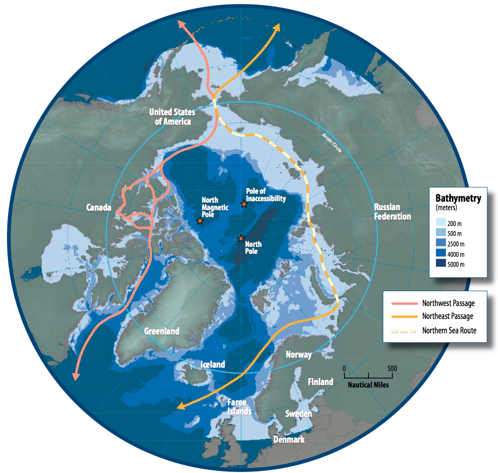
Yet of the primary identified shipping routes through the Arctic – the Northern Sea Route (NSR), Northwest Passage (NWP), and Transpolar Route (TPR) – only the NSR will have extended periods of opening through approximately 2025.
President Vladimir Putin has revived Russia's dreams of exploiting its Arctic territory – boosted by a warming climate that has opened up the Northern Sea Route.
The FT travels to remote reaches of Siberia to see if Russia can make it work.
New Opportunities
Shipping companies and countries alike are exploring the potential new trade routes.
Putin has exclaimed that the Northern Sea Route will rival international trade lanes and indeed, there has been an increase of vessel activity in the region.
In 2017, the Northern Sea Route Administration (NSRA) issued 662 permissions to vessels for navigation along the NSR, though only 107 of these for foreign (non-Russian) flagged vessels.
During that year, the NSRA notes that 9.74 million tons of various freights were transported by vessels, though mostly between ports located along the NSR.
Indeed, in 2017, there were only 24 vessels and 194,364 tons of cargo that transited the duration of the route – much less than the record high in 2013 when China’s COSCO and others sent cargos through to explore the possibility of a maritime route.
That year, aided by exceptional weather conditions, 71 vessels and 1.36 million tons of cargo transited the Northern Sea Route.
Yet this still pales in comparison to the Suez Canal traffic, which saw more than 17,600 vessels and 1.04 billion tons of cargo in 2017.
Weather and vessel size limitations – due to reduced water depths and widths limited to icebreaker accompaniment – will reduce the efficiencies of the commercial shipping industry, which values economies of scale and the just-in-time shipping model.
Arctic shipping in its current state is not yet reliable enough to adhere to these requirements, although when the Transpolar Route opens it may become more appealing.
China has already looked northward to link the “Polar Silk Road” to its broader One Belt One Road Initiative.
Yet weather will remain a challenge, with unpredictable ice floes moving into vessel routes, harsh storms, and cold operating temperatures.
The International Maritime Organization’s Polar Code was a solid effort to improve safety and establish training and operating standards for vessels in the Arctic, but it will likely need continuous updates to remain relevant.
International coordination on Arctic maritime safety and emergency response will be critical to ensuring the prevention – or expeditious response – of a maritime crisis.
Given the fragility of the environment, hostile conditions, and dearth of emergency response capabilities in the Arctic, cooperation will be critical to the future.
Another significant economic driver for the region is the abundant presence of energy both on shore and within the exclusive economic zones of the five Arctic coastal nations.
Several countries have already submitted claims to further extend their claims under the Commission on the Limits of the Continental Shelf.
This includes a number of overlapping claims, to include the Lomonosov Ridge – and the North Pole.
Although the United States remains the sole Arctic nation that has not ratified the United Nations Convention on the Law of the Sea (UNCLOS) it appears that all Arctic nations will submit claims in accordance with UNCLOS.
Yet the review of such claims make well take years due to the backlog of the Commission and the complexity of the review process.
Until then, there remains a potential for disputes over economic resources, although Norway and Russia resolved the biggest dispute in the region peacefully in 2010.
Currently the largest disputes in the Arctic are between the United States and Canada.
The Arctic ice is retreating due to climate change.
The region’s once inaccessible raw materials have caught the attention of major world powers. Countries like the USA, Russia and China are positioning themselves, scouting out the land and securing the best sites for getting their hands on the raw materials.
The animals of the Arctic are also having to fight - for their survival.
Russia already has an ultra-modern nuclear-powered icebreaker in operation.
The Norwegian company Statoil is conducting test drilling with its cutting-edge rig "Songa Enabler," which was designed especially for the Arctic; it’s the most northerly drilling operation in the world. Norway hopes to discover vast natural wealth in the Arctic.
But the borders in the Arctic have not yet been set, and a war over resources is always a distinct danger.
For the animals of the Arctic, including seals and polar bears, the melting sea ice is also having drastic consequences.
They’re losing their habitats and their search for food is becoming increasingly difficult.
In addition, the rubbish that is piling up in the Arctic only degrades very slowly and it’s poisoning the animals.
Seabirds and whales are dying because they can’t digest the plastic in their stomachs.
International fishing fleets are the main culprits when it comes to rubbish in the Arctic.
The ice used to be a natural barrier.
Now the trawlers can penetrate further and further into the icy ocean and, as a result, catch greater quantities of fish.
Overfishing is almost inevitable.
Furthermore the huge trawl nets used by the industrial fishing fleets are destroying the ocean floor, an important habitat.
For years, environmental organizations such as Greenpeace have been complaining about the problems caused by fishing and raw-material exploitation in the Arctic.
While oil and gas reserves are still unknown, it is estimated that the Arctic may hold nearly one-third of the world’s natural gas and thirteen percent of global oil reserves.
Yet costs of exploring, developing, and extracting these resources are very high given the harsh environment, limited infrastructure, and difficulties posed.
Given the current market prices, there is limited interest in pursuing these reserves in North America, though Norway and Russia are continuing development in the Barents and Kara Seas.
The Chinese Nanhai-8 rig made an April 2018 discovery that may rank the Leningradskoye field as one of Russia’s largest natural gas fields.
Indeed, China has also invested in the Yamal LNG project, which has ownership of 50.1 percent by Novatek, 20 percent by total, 20 percent by China National petroleum Company, and 9.9 percent by the Chinese Silk Road Fund.
Production officially began in December 2017 and officials predict an annual production of up to 360 billion cubic meters of gas.
The new Christophe de Margerie class of icebreaking LNG carriers – projected to be a total of 15 vessels at more than $300 million apiece – has commenced deliveries from Yamal to Asia.
While the transit shipping of cargo may not be viable for decades, it is clear that Russia is intent on using the Northern Sea Route to ship commodities to market, albeit on a small scale when compared to the global maritime industry.
Overall production of Arctic energy reserves will likely remain limited in the near future, unless the price of oil climbs significantly.
Other sources of oil and gas – to include shale and using newer technology on older fields – will continue to remain a more economical option.
Mineral resources are also found in vast quantities throughout the Arctic, with all Arctic nations except Iceland possessing significant mineral deposits.
While some new deposits are being revealed as ice coverage melts, it is likely that development in the near term will continue to focus on existing mines.
It is predicted that infrastructure to these mines and areas will steadily be improved to permit future access.
Changes in climate are also likely to result in increased fishing in the Arctic.
While there is little data on exact sizes of Arctic fishing stocks, it is likely that fish will continue migrations northward as the waters warm in the south.
International fishing fleets will follow these fish, and the level of illegal and unreported fishing will likely rise due to the challenges of monitoring the vast region and lack of comprehensive maritime domain awareness.
Yet this is also another opportunity for the Arctic coastal states to work together, in regulating and monitoring fishing.
Likewise, the regulation of tourism in Arctic water – and the establishment of clear safety and emergency response protocols – will require cooperation from the Arctic states as the numbers of tourists rise.
Indeed, the 2016 and 2017 Northwest Passage transits of the Crystal Serenity cruise ship and 1,800 passengers (900 guests) highlight the importance of developing both regulations and crisis response procedures as the adventure tourism industry continues to grow.
A final economic factor in the Arctic will be foreign direct investment.
To date, the Arctic has received significant levels of FDI, with China being the largest source at an estimated $1.4 trillion invested into the economies of the Arctic nations from 2005-2017.
Concerns arise over the potential for externalities associated with this investment, particularly given China’s record on labor and environmental issues.
China’s recent Arctic White Paper establishes that China will continue to seek investment and other economic opportunities in the region.
Conclusion
The Arctic is brimming with economic potential.
Though the population will continue to be a small fraction of the global population, the region has significant natural resources and potential as a maritime trade route.
With an annual economy presently exceeding $450 billion, it is likely that the region will experience further growth as the Arctic becomes increasingly accessible.
Yet Arctic states must carefully regulate this growth in order to ensure protection of the environment, indigenous peoples, and their own strategic interests.
This will further require significant cooperation amongst the nations of the High North – and those with interests in the region – in order to ensure the development and adherence to protocols and regulations that guide economic development.
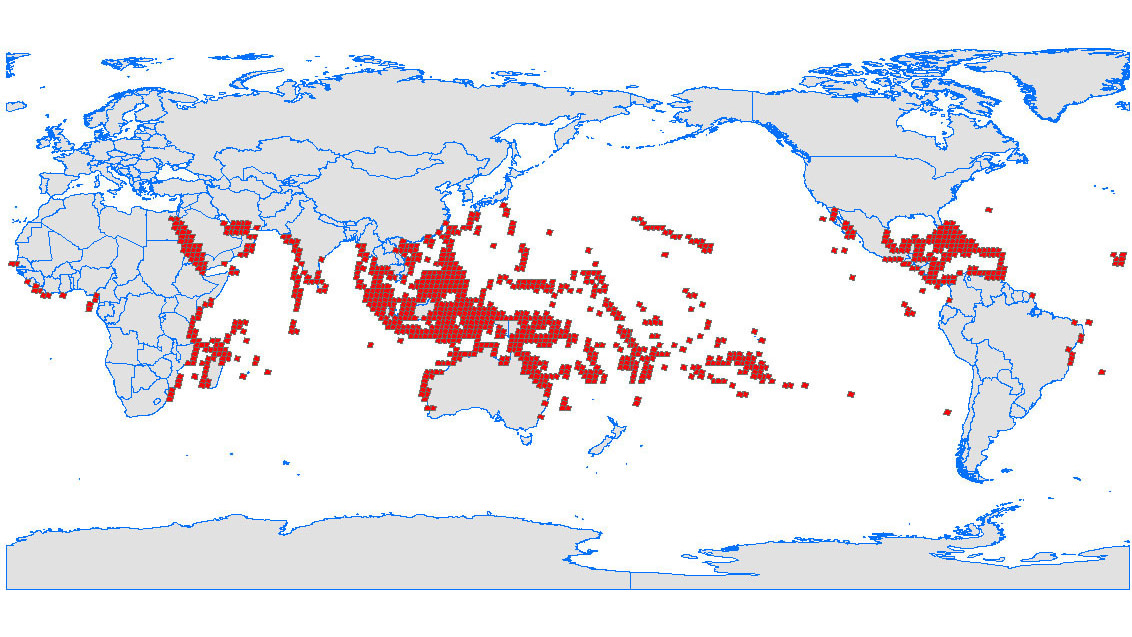
Scientists are using a cool new technology to map coral and figure out which types can withstand warmer oceans and climate change.
There is no comprehensive map of the world’s coral reefs.
And that’s a problem because these ecosystems are some of the most important on the planet: they house a huge percentage of the ocean’s species, they absorb 70 percent of the wave energy coming to shore, and they attract $37 billion worth of tourism every year.
Moorea Island reefs, French Polynesia. March 22, 2018.
Copyright: 2018 Planet Labs, Inc.
They are also in grave danger.
As the climate warms, the oceans are absorbing much of that heat—which in turn makes the water more acidic, which causes coral bleaching (a state that makes them vulnerable to dying off).
To better understand the state of the world’s coral, the Nature Conservancy, a non-profit that works to preserve land and water under threat around the world, is using a new technology to image and map all the coral reefs in the world.
“We are always crying out: corals, corals, corals are in bad shape! But we don’t have very good maps.
When you see a map it’s the kind of map you use for navigation so ships won’t run aground.
They look like little clouds.
But when you go diving you see a coral reef is way more complicated than that.
Information at that level of detail only exists when scientists go diving, do transects, and measure the field.
But we are limited by our diving capabilities and time,” says Luis Solórzano, Executive Director for The Nature Conservancy in the Caribbean.
Starting in the Caribbean, the goal is to create a comprehensive baseline of the world’s reefs.
Specifically, they want to map which species live in each reef so they can better understand which ones are surviving the warming climate and which ones are dying off.
They are doing this with a special technology developed by Greg Asner.
Called the Carnegie Airborne Observatory (CAO), the device has four sensors: two different spectrometers, a camera, and a wLIDAR scanner.
Flying the CAO over the corals, Asner is able to capture the chemical fingerprint and composition of what is living below the surface of the water.
Coral Reefs of the World Classified by Threat from Local Activities
Once the data is collected, it is compared to satellite images, drone footage, drop cameras (which take underwater images), and data gathered by SCUBA divers.
Solórzano says that the divers, specifically, can help pair species names with the chemical signatures picked up by the CAO.
“When you go down there and measure it exactly, you can identify what different signatures you’re seeing: that’s sand, that’s a reef covered by algae,” he says.
In this way the technology can be trained to identify exactly what it’s seeing.
The Caribbean is just the first step in a series of flights that will map and categorize reef systems all over the world.
Solórzano says this should be accomplished in no more than two-and-a-half to three years.
The maps will then be used to create plans for preservation, protection, and restoration of reefs.
“Imagine if you need to design network of marine protected areas.
That map is essential,” he says.
He also notes that in the Caribbean, the plan is to begin physically restoring coral reefs by using the maps to show them which corals are most stable in the changing ocean.
Once the Caribbean map is made, they will begin taking corals from the water, growing them on land, reproducing new ones in their nurseries, and then returning them to ocean.
“You want to put back into the water those that are resistant.
We’re going to do that for the first time,” he says.
“We’re are learning how to do it.”
Restoring corals on land and returning them to the sea isn’t exactly a new idea.
The University of Miami, for example, has been running The Coral Restoration Project, in which they’re using nurseries to propagate staghorn coral, since the 1970s.
But it is a program that is gaining steam—and becoming increasingly more essential as scientists are beginning to suggest that the die-off of coral reefs around the world could be indicating an extinction event.
“Corals are one of the most important systems in the global oceans.
Globally they provide food and livelihood to more than 500 million people,” Solórzano says.
“They have gone through global extinctions in the past and it seems like we're about to push them to another.” But hopefully with the combination of our new global maps and restoration projects like those from the Nature Conservancy we can keep them healthy for as long as possible.
Shipping containers of China Ocean Shipping Company (COSCO) and Hyundai
cross the Gulf of Suez towards the Red Sea before entering the Suez
Canal, in El Ain El Sokhna in Suez, east of Cairo, Egypt April 24, 2017.
(Amr Abdallah Dalsh / Reuters File Photo)
This summer COSCO plans to send as many vessels on the Northern Sea Route as it has during the past three years combined.
Starting with the voyage of the Yong Sheng in 2013, the Chinese shipping firm COSCO has sent 10 vessels on a total of 14 voyages along the Northern Sea Route, in Arctic Ocean waters north of Russia.
The company announced last week that this summer it will send 10 more, at a time when Beijing is seeking to include Arctic shipping in a trillion-dollar investment initiative that puts China at the center of a new network of global trade routes.
Icebreaker Xuelong became the first Chinese vessel to complete a voyage through the Arctic's Northwest Passage in Sept. 2017.
Xue Long 1, a Ukraine-made icebreaker bought in 1994.
Photo: Handout
Dubbed the “Polar Silk Road” by Beijing, Arctic shipping on the Northern Sea Route is promoted by COSCO as “strategically important” to the shipping industry because it provides a cost-effective trade route for Chinese and European firms.
“The normalization of Arctic Northeast Route fully proves its value and potential,” the company said in a statement published earlier this year.
Map of the Northern Sea Route taken by Chinese cargo vessel Tianjian.
A Chinese cargo ship arrives in Denmark through a sea route via the Arctic Ocean. Tianjian is the third of six Chinese cargo ships to ply the northern route to Europe in 2017, as part of the China-proposed Belt and Road Initiative.
COSCO’s growing interest in using the Northern Sea Route comes amid a decline in the number of ships opting to sail the northerly route.
However, company figures, presented during the World Transport Convention in Beijing, underscore the economic benefits it and other firms stand to gain if the route can be developed.
Northern Sea Routes (1942)
COSCO calculates that the Northern Sea Route voyages its ships have made to date cut a combined 221 days of shipping time compared with the route that passes through the Suez Canal.
The shorter sailing time amounts to a reported $10 million in costs.
Although first officially linked to the Belt and Road Initiative in June 2017, Beijing’s interest in Arctic shipping gained renewed attention earlier this year with the release of China’s first policy paper about the region.
In part, this was due to the Beijing’s apparent willingness to invest in developing the route. Recent announcements that a large portion of Chinese investments in Russia are destined for the Arctic appear to indicate that that is a promise it is willing to make good on.
Some fear, however, that allowing China to underwrite development of Arctic shipping means handing over control to Beijing.
Critics point to wording in Beijing’s Arctic policy stating that it feels countries should be ensured that they have the right to use Arctic shipping lanes.
 Helheim glacier DGA nautical chart with the GeoGarage platform
 Helheim glacier observed by NASA