Friday, December 31, 2021

How to build the ultimate superyacht for isolating on board


From BoatInternational  by Elaine Bunting


Escaping from the world is always possible on a yacht.
Now, says Elaine Bunting, many owners want to live and work aboard for even longer


One of the unforeseen consequences of being locked down for much of 2020/2021 was that owners spent more time on their yachts – if they could get to them.
One-week trips to the boat were being extended to two or three weeks, and some owners even chose to ride out the worst of the pandemic on board.
Charters, too, were affected, with brokers reporting that while bookings were down, charterers were taking trips for longer periods.

This shift in usage has demanded new thinking from the superyacht industry.
How do you turn a yacht that was designed for brief stays into a semi-permanent home, and a place to work?


Credit: Burgess

“[Covid-19] has brought it home to people that they can spend more time on board if they need to,” says designer Jonny Horsfield.
His company, H2 Yacht Design, is behind long-range yachts such as 63.7-metre explorer vessel Scout and REV Ocean, a 182.9-metre expedition vessel that, when delivered, will become the world’s largest superyacht.
The studio’s portfolio also includes 75-metre Feadship Arrow, launched last summer, and 123-metre Lürssen Al Lusail from 2017.

“Generally speaking, I would say the interesting new yachts are much as they were a year ago but with more comfort, storage and supplies,” he observes.
“People are looking for a more casual solution to comfort rather than concentrating so much on what is normal or good for charters, and they wish to customise a little more.”

Storage, Horsfield says, is often compromised in order to squeeze in extra guest space.
Next-generation yachts fit for longer-term living will need more.
“I don’t think there’s a [specific] figure you need, it’s just more important to get it right than in the past,” he adds.
Read on for more tips for enjoyable longer spells on board.

Upgrade the onboard office


Luminosity has an office-cum-conference room that is almost the same size as the master cabin
Credit: Burgess


“More people are working remotely, especially now they have seen that it works really well,” says sailing yacht designer Bill Dixon.
“Video conferences have improved immensely so maybe travelling for work will become the second option.
Owners can actually spend time on their yacht and work and earn money.”

At the extreme end of what is possible, REV Ocean is fascinating, designed to operate independently for months in remote areas from the Arctic to the Antarctic, and be interchangeable with an office environment ashore.
“You could run your entire business from that yacht,” says Jonny Horsfield.
“It has a functional business centre and a recreation of the owner’s entire office.
We have allocated a whole office suite and a trading room where you can have six guys on screens, as well as a massive conference room that can seat 35 directors where you can have board meetings – and they can all stay on board. It’s massive, bigger than most companies’ offices.”

The nature of boats was starting to change before the pandemic and this is now happening more rapidly, says Canadian naval architect Gregory Marshall.
“What we are seeing is a lot more self-contained long-range boats being away for four to six months.
This is a definite shift, and it’s across the board from 25 and 26 metres to our largest extended range project of 82 metres and everything in between."

“More than 50 per cent of clients consider their office [in the design] and we have certainly been doing more video conference rooms and more common spaces off a sky lounge rather than the owner’s suite so people can sequester themselves in that.”

Create dual-use spaces to maximise what you can do


The beach club on Life Saga
Credit: Giuliano Sargentini


A yacht is all about enjoying downtime, family time and holidays, and there will continue to be a need for flexible, multi-use spaces.
Designer Tim Heywood thinks that the experience owners and their families had of isolating on yachts gave some “the opportunity to turn hard times into a diverting and potentially enjoyable experience.”

With that in mind, size matters.
“It is possible to enjoyably isolate aboard a moderately sized yacht of, say, 30 metres, but to take a sizeable family with back-up staff and full health facilities, I would aim for something in the region of 70 to 90 metres with a touch-and-go helipad.”

For longer periods it is paramount, Heywood feels, to have facilities to keep family and guests entertained.
“You need a saloon that can double as a cinema, if you don’t have a cinema planned, and a dining room that is equipped with conferencing facilities.
Children’s play and craft rooms and additional gym equipment are all facilities that should be maximised.”


The cinema on board 83m Here Comes The Sun
Credit: Jeff Brown/Breed Media


The 83-metre Amels Here Comes The Sun, 68-metre Amels Neninka (previously Aurora Borealis) and 86-metre Oceanco Seven Seas are examples of superyachts that have cinemas that can be used as lounges, and a growing number of yachts, including recently delivered 80-metre Artefact, feature a play and craft room for children

The same applies outdoors, which can also be set up for multi-use, with more flexible arrangements than the normal fixed sofas and sunbeds, “allowing different layouts to add surprises to every day”, says Heywood.

Laura Pomponi, founder and CEO of Luxury Projects, says that versatile, convertible areas are more in demand than ever.
Lounge areas that can become a cabin, a gym that can be turned into a recreation area or an office, or a beach club that can be a cinema are all examples she cites.
Amenities such as balconies, saunas, spas and gyms are prized, particularly when guests are restricted in going out or have time on their hands, and convertible areas allow the living space to be varied.


The family deck craft room on Artefact
Credit: Francisco Martinez


Pomponi and other designers say clients have been asking for a more homely, residential feel.
That means comfy sofas, high-end AV systems and high-speed communications.
It might also mean a different interior style.
“The minimalism we have seen in interiors in last few years with lacquered surfaces and strong contrasts doesn’t work any more,” Pomponi says.
“We are back to veneers, warm light, linen fabrics and calm tones.”

Gregory Marshall agrees that there is a move away from elaborate interior styling, driven by the wish for a cleaner aesthetic.
“In the last few months people have settled into the concept of being germophobes, and that is changing interior design itself,” he observes.
“People want fewer nooks and crannies that are hard to clean.”

Invest in better systems


70m Joy has a beach club that doubles as a disco
Credit: Feadship


“Family is one thing. Friends? Well, you know what they say: after a week, friends are like fish, they go off!” says the owner of a 41-metre explorer when asked for his advice on spending long periods on board. You need “a good chef who makes every meal an interesting part of the voyage, and one who takes into account each of the guests’ particular needs.”

Asked what else he would recommend, he replies: “Good separation of owner, guests and crew, tenders that are multifunctional and seaworthy, enough fuel at cruising to cross the Atlantic and Pacific Oceans from, say, the US and full displacement and the ability to handle rough conditions.
Also, living areas that feel warm and look warm in cold climates, and a lot of spares and backups.”

But if good food is essential, the facilities and systems that make it all possible longer term need to be planned in a new build or refit.
In more remote places without regular access to shore, where crew can’t be flying in food from all over the world, thought has to be given to how food would be stored using extended fridges and freezers.
You need more, and bigger, storage, perhaps also rubbish and waste-handling systems, plus bigger tanks for fuel and black water.


A 47m Laura Pomponi project for Feadship with a flexible upper deck lounge/gym (above) with fold-down bed (below)
Credit: Luxury Projects


Daniel Nerhagen, from Swedish studio Tillberg Design, has worked on the build and refit of superyachts from 72-metre Serenity and 69-metre Saluzi all the way up to cruise ships.
A point he makes is that cold storage allocation for provisions and rubbish is critical for independence but seldom easy to create in an existing vessel.

“On many yachts we have a very long range with fuel to be at sea or at anchor and that is not a challenge.
But most are used to being able to restock every week,” he says.
“With the Covid-19 situation, yachts were parked outside the harbours and crew were not allowed ashore.
That led to challenges, as they didn’t have the space.”

So what can be done on existing yachts? 
“You could take out all the tenders and add fridges and build cold rooms on deck,” he suggests.


Waste-handling systems area also becoming more sophisticated.
They are widely used on cruise ships, which can generate up to 10,000kg of rubbish and solid waste every day.

“To recycle food waste you can get machines that remove the water and dry the organic material, turning it into powder, and you store that in boxes,” Nerhagen says.
“All these waste-handling and compaction systems are available but you need to allocate space for them.

Most yachts don’t have it and it is hard to retrofit.”Nerhagen observes that new regulations and standards in the cruise industry are resulting in older vessels being scrapped. 
“Looking at another market segment, cruise ships, a lot from the early 1990s are going to scrap as they are not complying with the latest regulations and you cannot retrofit these systems. It’s cheaper to build a new ship than to comply.”

 
“We are definitely seeing much bigger toys on board for going to remote places”
Credit: Tom Van Oossanen


Easy, fast access from shore is another essential requirement when living on board for longer periods.
Yachts need to carry good tenders, preferably covered.
For larger yachts travelling to new destinations, or away for longer, a certified helipad becomes important.

“We are definitely seeing much bigger toys on board for going to remote places,” says Gregory Marshall.
“If you want to do a 200-mile trip you need a tender that can do that.
The 82 metre we’re working on packs an 18-metre tender.”

Another consideration for ensuring smooth running for a longer period is crew rotation, which can have an impact on the space set aside for crew quarters.
“It’s not always high on the list of priorities,” says designer Jonny Horsfield, “but you need to think about how the crew are being looked after.
A lot I know are confined to the yacht and it is not great for them so the idea of having more space would be good.”


None of these changes necessarily demands a new build.
Royal Huisman recently redelivered 56-metre Feadship Broadwater with a brief to turn her into “a modern and liveable home from home.” To achieve this, the transom was removed and the yacht extended by four metres and given a restyled stern with an aft deck and beach club.
Outdoor amenities include a new hot tub on the sundeck and a bar.

The yard is working on a conversion of a 43-metre Ron Holland-designed ketch from 1993, Juliet, to hybrid propulsion.
This will allow more silent running and to take advantage of her fuel storage for longer periods away from port.

H2 is working with a client who is looking for more space and wants to lengthen an existing yacht rather than wait for a new build.
The project would cut the yacht in the middle and extend it by around 10 per cent, leaving the engine room intact.
Large doors opening out on to balconies will be added, and more space for the owner, with another suite, cinema, and bigger dining room, while the old spaces will now be office areas.

Get ahead in technology


Besides fostering changes in design thinking, the quest for independence could also drive interest in sustainability.

“This is a big topic and it comes up at every client meeting,” says Daniel Nerhagen from Tillberg Design.
“How can you be self-sufficient? Wind turbines, solar panels, battery packs and fuel cells – how to extend your range or reduce fuel consumption and run the generator for only a few hours per day.

“These systems require more space than traditional diesel engines so it’s always a question of your priorities.” But, he adds: “For many people, the technology is a showcase.
It will accelerate – that’s inevitable.”

Bill Dixon, of Dixon Yacht Design, specialises in sailing yachts, such as the 55-metre Dixon 175 and the 70-metre Project NewDawn.
The latter is something of a crossover, a sailboat with an easily handled free-standing rig that has similar accommodation to a motor yacht of the same size, and for a comparable cost.


Technology that regenerates power from self-propulsion is the future, Dixon believes.
“Where it really does key into self-sufficiency is that, if you have some sail power, you have a way of generating electricity.
As we know now, Black Pearl nearly runs the vessel if it is sailing at a reasonable wind speed.
I believe we will see a lot more of that.
People like the idea."

“Then there is taking the energy you generate and making hydrogen for fuel,” he adds.
“On one of my potential projects, a client has already investigated fuel cell technology.
In the scheme of things, a large yacht of 100 metres can go fast and generate a lot of free energy.
If you really want to do something incredibly special, this is the way to look at one future for large, eco-friendly superyachts.”

Explore new places

Credit: Tom Van Oossanen
 
A popular prediction throughout 2020 was that people’s appetite for travel would dwindle.
Don’t bet on it; you just have to look at the huge uptake in private jets.

“I think people will want to travel but to new destinations, which is why the range and ability to be away for longer is important,” says Dixon.
If anything it’s possible there could be an upsurge in the desire to spend more time exploring and visiting new places or more unusual destinations.

“Owners are not giving up free time; they need their holidays.
Leisure time is important,” agrees Daniel Nerhagen.
“A yacht is still probably the safest place you could be and where you can escape all the current situation.”

A yacht that has been refitted or built to create the right environment and spaces for longer-term living, working and relaxation will allow owners and guests to take maximum advantage of the new working-from-home culture.
Could such configurations eventually become a new norm?
“What has happened [in 2020] will change people’s thinking about future projects,” says Nerhagen.

Credit: Tom Van Oossanen
 
For those who have made changes, the timing could hardly be better: a radical shift in the variety of ways business is conducted opens up new freedoms and broader horizons.

“It is its own bubble,” remarks the owner of his 55-metre explorer yacht, who spends months at a time on board with his family.
“It protects you from some parts of the world and allows you to build a strong family bond.
There is no greater luxury than being on a yacht.”
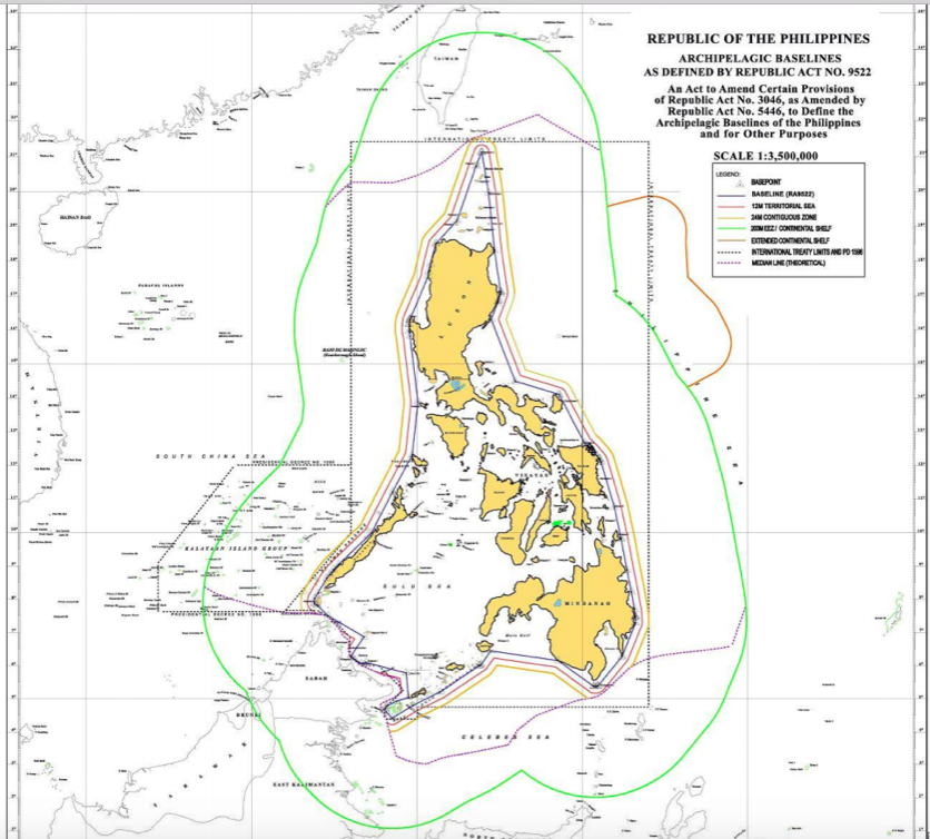
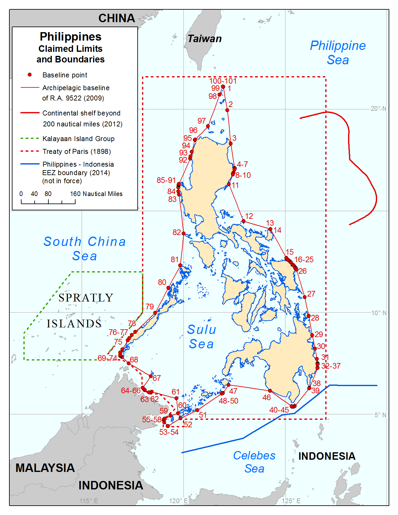
Links :

Thursday, December 30, 2021

Scientists build new atlas of ocean’s oxygen-starved waters

Oxygen deficient zone intensity across the eastern Pacific Ocean, where copper colors represent the locations of consistently lowest oxygen concentrations and deep teal indicates regions without sufficiently low dissolved oxygen.
 Credit: Jarek Kwiecinski and Andrew Babbin
 
From MIT News Office by Jennifer Chu

The 3D maps may help researchers track and predict the ocean’s response to climate change.

Life is teeming nearly everywhere in the oceans, except in certain pockets where oxygen naturally plummets and waters become unlivable for most aerobic organisms.
These desolate pools are “oxygen-deficient zones,” or ODZs.
And though they make up less than 1 percent of the ocean’s total volume, they are a significant source of nitrous oxide, a potent greenhouse gas.
Their boundaries can also limit the extent of fisheries and marine ecosystems.

Now MIT scientists have generated the most detailed, three-dimensional “atlas” of the largest ODZs in the world.
The new atlas provides high-resolution maps of the two major, oxygen-starved bodies of water in the tropical Pacific.
These maps reveal the volume, extent, and varying depths of each ODZ, along with fine-scale features, such as ribbons of oxygenated water that intrude into otherwise depleted zones.

The team used a new method to process over 40 years’ worth of ocean data, comprising nearly 15 million measurements taken by many research cruises and autonomous robots deployed across the tropical Pacific.
The researchers compiled then analyzed this vast and fine-grained data to generate maps of oxygen-deficient zones at various depths, similar to the many slices of a three-dimensional scan.

From these maps, the researchers estimated the total volume of the two major ODZs in the tropical Pacific, more precisely than previous efforts.
The first zone, which stretches out from the coast of South America, measures about 600,000 cubic kilometers — roughly the volume of water that would fill 240 billion Olympic-sized pools.
The second zone, off the coast of Central America, is roughly three times larger.

The atlas serves as a reference for where ODZs lie today.
The team hopes scientists can add to this atlas with continued measurements, to better track changes in these zones and predict how they may shift as the climate warms.

“It’s broadly expected that the oceans will lose oxygen as the climate gets warmer.
But the situation is more complicated in the tropics where there are large oxygen-deficient zones,” says Jarek Kwiecinski ’21, who developed the atlas along with Andrew Babbin, the Cecil and Ida Green Career Development Professor in MIT’s Department of Earth, Atmospheric and Planetary Sciences.
“It’s important to create a detailed map of these zones so we have a point of comparison for future change.”

The team’s study appears today in the journal Global Biogeochemical Cycles.

Airing out artifacts


Oxygen-deficient zones are large, persistent regions of the ocean that occur naturally, as a consequence of marine microbes gobbling up sinking phytoplankton along with all the available oxygen in the surroundings.
These zones happen to lie in regions that miss passing ocean currents, which would normally replenish regions with oxygenated water.
As a result, ODZs are locations of relatively permanent, oxygen-depleted waters, and can exist at mid-ocean depths of between roughly 35 to 1,000 meters below the surface.
For some perspective, the oceans on average run about 4,000 meters deep.

Over the last 40 years, research cruises have explored these regions by dropping bottles down to various depths and hauling up seawater that scientists then measure for oxygen.

“But there are a lot of artifacts that come from a bottle measurement when you’re trying to measure truly zero oxygen,” Babbin says.
“All the plastic that we deploy at depth is full of oxygen that can leach out into the sample.
When all is said and done, that artificial oxygen inflates the ocean’s true value.”

Rather than rely on measurements from bottle samples, the team looked at data from sensors attached to the outside of the bottles or integrated with robotic platforms that can change their buoyancy to measure water at different depths.
These sensors measure a variety of signals, including changes in electrical currents or the intensity of light emitted by a photosensitive dye to estimate the amount of oxygen dissolved in water.
In contrast to seawater samples that represent a single discrete depth, the sensors record signals continuously as they descend through the water column.

Scientists have attempted to use these sensor data to estimate the true value of oxygen concentrations in ODZs, but have found it incredibly tricky to convert these signals accurately, particularly at concentrations approaching zero.

“We took a very different approach, using measurements not to look at their true value, but rather how that value changes within the water column,” Kwiecinski says.
“That way we can identify anoxic waters, regardless of what a specific sensor says.”

CTD-rosette of Niskin bottles capable of collecting water at depth and making continuous oxygen measurements.
Credits:Mary Lide Parker
 
Bottoming out

The team reasoned that, if sensors showed a constant, unchanging value of oxygen in a continuous, vertical section of the ocean, regardless of the true value, then it would likely be a sign that oxygen had bottomed out, and that the section was part of an oxygen-deficient zone.

The researchers brought together nearly 15 million sensor measurements collected over 40 years by various research cruises and robotic floats, and mapped the regions where oxygen did not change with depth.

“We can now see how the distribution of anoxic water in the Pacific changes in three dimensions,” Babbin says.

The team mapped the boundaries, volume, and shape of two major ODZs in the tropical Pacific, one in the Northern Hemisphere, and the other in the Southern Hemisphere.
They were also able to see fine details within each zone.
For instance, oxygen-depleted waters are “thicker,” or more concentrated towards the middle, and appear to thin out toward the edges of each zone.

“We could also see gaps, where it looks like big bites were taken out of anoxic waters at shallow depths,” Babbin says.
“There’s some mechanism bringing oxygen into this region, making it oxygenated compared to the water around it.”

Such observations of the tropical Pacific’s oxygen-deficient zones are more detailed than what’s been measured to date.

“How the borders of these ODZs are shaped, and how far they extend, could not be previously resolved,” Babbin says.
“Now we have a better idea of how these two zones compare in terms of areal extent and depth.”

“This gives you a sketch of what could be happening,” Kwiecinski says.
“There’s a lot more one can do with this data compilation to understand how the ocean’s oxygen supply is controlled.”

This research is supported, in part, by the Simons Foundation.

Links :

Wednesday, December 29, 2021

Automatic shipwreck detection in bathymetry data


From Hydro by Dylan Davis, Dani Buffa, Amy Wrobleski

Hydrological Algorithms Help to Uncover Sunken History

Archaeologists have long been interested in shipwrecks.
These sites can tell us about ancient transportation and trading routes, technological innovations and cultural exchanges over thousands of years.
Documenting shipwrecks can be a difficult task, however.
With breakthroughs in remote sensing technology (specifically sonar and radar), researchers have been able to acquire highly resolved maps of ocean floors. Consequently, we can also locate cultural objects – like shipwrecks – sitting on the bottom of oceans, lakes and other bodies of water.

Machine learning, AI and other computerized methods of analysing imagery have made incredible strides possible in many research areas.
Algorithms have been devised to locate everything from buildings, roads and people to more specific objects like aeroplanes, ships and animals. Archaeologists, too, have begun using AI to locate ancient settlements.
Recent research shows how the use of such automated methods can help reveal a seascape of human history sunk at the bottom of the ocean.

Bathymetry and Shipwreck Archaeology

Researchers have used bathymetric datasets to locate everything from ancient Roman and Greek vessels to World War II aircraft carriers.
Technical studies of specific bathymetric data types have shown that shipwrecks can be identified in high-resolution imagery, but smaller or highly damaged wrecks are not as easy to locate.
While most shipwreck archaeology has used bathymetric datasets produced by sonar and radar instruments, which are collected from boats or submerged vessels, some researchers have utilized bathymetric datasets collected from the air, specifically Lidar.

Lidar (light detection and ranging) data, collected using pulses of light to record 3D surfaces, has made headlines within archaeology for its ability to detect cities hidden under jungle and forest canopies. However, there are actually two kinds of Lidar data: topographic Lidar (which is used to locate features on land), and bathymetric Lidar (which can penetrate water and map shallow ocean floors). Archaeologists have used bathymetric Lidar to detect shipwrecks in shallow waters around the world. One limitation of Lidar, however, is that the water must be calm and clear for proper data collection.

The ‘Big Data’ Problem and Underwater Archaeology

The use of 3D data like bathymetry and topography has improved researchers’ ability to detect objects in image datasets.
Shipwrecks, which appear as mounds at the ocean’s bottom, can therefore be identified based on their depth compared to the surrounding ocean floor.
However, the ocean is vast, and recording shipwrecks and other features by hand is extremely time consuming and expensive. To this end, there are many different methods that can be used to automatically extract information from images.

The use of AI and machine learning methods have become increasingly popular as they can be extremely precise, but these methods are also very complicated and require high levels of processing power to implement
 There are also other methods of pattern recognition that use a variety of object characteristics to create expectations for a computer to locate new objects.
These can include colour, shape, texture, size and height, to name just a few.

Generally speaking, the greater the number of characteristics considered in a detection algorithm or model, the more accurate the detection becomes.
This is particularly true if the features of interest are complex and highly variable. Different methods have had varying levels of success in detecting a range of feature types.
Within archaeology, for example, automated techniques have successfully located urban complexes in Central America, Native American constructions in the United States, and tens of thousands of archaeological burial mounds and tombs across Europe and parts of Asia.
Among marine archaeologists, however, these methods have not yet been extensively adopted.
 
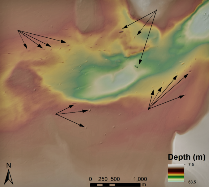
Figure 1: Shipwrecks visible in bathymetric data from the National Oceanic and Atmospheric Administration in the United States. Arrows highlight some of the larger visible shipwrecks.
Credit: Dylan Davis, Danielle Buffa & Amy Wrobleski (2020). 
(Source: https://doi.org/10.3390/heritage3020022)

For automated methods like machine learning and AI to work, image data must be at a fine enough resolution to detect patterns related to the target of interest.
For example, to locate a sunken cruise liner, your data resolution can be lower than if you are looking for a canoe or kayak.
For a cruise liner, your data resolution can be lower because the object is large and easy to spot, even if the imagery is not highly detailed. In contrast, something small, like a canoe or kayak, needs finely grained data to keep it from blending into the noise of coarser-grained datasets. In several countries around the world, including the United States and the United Kingdom, high-resolution bathymetric data (like sonar, radar and Lidar) is widely available.
This data can allow researchers to develop automated methods for locating shipwrecks, many of which can have historical or archaeological significance (Figure 1).

Sinkhole Algorithms and Shipwreck Detection

Because intact shipwrecks show up as mounds or lumps on the ocean floor, one particularly simple way to try and automate their detection is to use sinkhole extraction algorithms. These methods were originally developed by hydrographers to locate watersheds, sinkholes and other concave topographic features.
In some of our recent research, we used a sinkhole extraction algorithm developed by geographers to detect shipwrecks located in up to 50m of water.
To use these methods to locate ‘mounded’ features, you just need to invert the bathymetric data to turn ‘mounds’ into ‘sinks’ (Figure 2).
In this way, shipwrecks become sinkholes that the algorithm can identify (Figure 3).
 
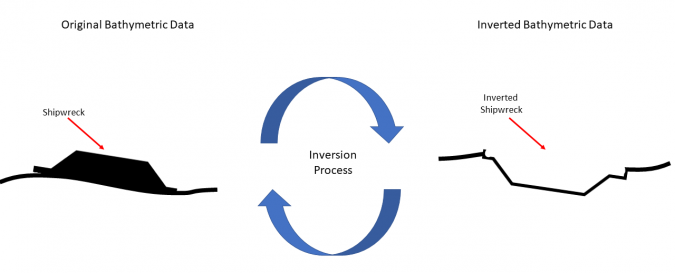
Figure 2: Illustration of how inverting bathymetric data works for detecting shipwrecks.
The original dataset is flipped so that a mounded wreck becomes a hollow depression.
The algorithm can then ‘fill’ that depression to detect a shipwreck as if it was a sinkhole or topographic depression.
Credit: Dylan Davis.

Using this inversed sinkhole method, shipwrecks can be systematically identified in vast bathymetric datasets.
Because the method is reproducible, researchers can use it on any dataset from any location and different researchers will produce identical results.
This also helps to make research more reliable by limiting potential errors introduced by individual analysts.
Especially considering the vastness of submerged areas around the world, a time-effective, reproducible method is important for underwater investigations.
This is especially relevant for underwater archaeological work because submerged cultural heritage must be recorded before it is destroyed by natural and human events.
 
Figure 3: Example of detected shipwreck locations in the United States using sinkhole extraction algorithms. Credit: Dylan Davis, Danielle Buffa & Amy Wrobleski (2020).
Source: https://doi.org/10.3390/heritage3020022.

How Useful are Automated Methods?

Because of their complexity and often imperfect results, some may wonder if using these methods is worth it.
After all, if you can scan through data and pick out shipwrecks perfectly in a couple of hours, why take all that time to train a model?
Without a doubt, for researchers focusing on a limited study area, automation may not represent great use of their limited time.
However, if the scale of a research project is larger – perhaps ocean-wide, or regional covering thousands of miles of coastline and open water – then the speed at which automated methods can conduct a preliminary evaluation of the data makes them worth the effort.

In an automated study of shipwreck detection conducted in the United States, we found that a sinkhole extraction algorithm could detect approximately 75% of known shipwrecks within the study region. Certainly imperfect, but a pretty good initial attempt.
What was more impressive was that the method could locate shipwrecks exponentially faster than human analysis (requiring only about 3 minutes to detect over 200 shipwreck sites).
When doing this by hand, it took us nearly 10 hours to record that many shipwrecks.
So, even though the algorithm may have missed some shipwrecks, it saved us hours of time, and this is just for a small study area of about 20km2.

Conclusion

Recent research has demonstrated the potential for the automated detection of shipwrecks using mathematical models.
This work promises to rapidly expand the capacity of researchers to investigate the ocean floor for remnants of human history.
The archaeological record is fragile and, once lost, this information can never be recovered.
For submerged capsules of human history, improving our ability to detect and monitor these sites is an important undertaking, and one which computer automation is well suited to assist in.

For those interested in using automated methods for shipwreck (or other object) detection, there are many tools available within GIS systems (including open source platforms like QGIS, WhiteBox GAT and SAGA, among others), as well as some online tutorials using ArcGIS Pro and deep learning.

Tuesday, December 28, 2021

The Philippine maritime zones


From The Manila Times by Saul Hofileña Jr.

The Convention enumerated maritime zones and their entitlements.
An entitlement refers to the right to the established maritime zones.
The Philippines must reckon the point of beginning of its maritime zones from straight baselines established around the archipelago of the Philippines.

There are two methods of measuring baselines.
The first is the straight baseline method and the second is the normal baseline method.
If a baseline is drawn around an archipelago in accordance with Art.
47 of Unclos III, then it is called an archipelagic straight baseline.
In the straight baseline method, the State draws straight lines from selected points along its shoreline.
 

Under the normal baseline method, the low-water mark, the land that is visible during low-tide or where the sea water meets the temporary shoreline created during the low tide, is the starting point for the baseline.
In this matter, the Philippines is one of the very few States that was allowed to establish straight lines around its archipelago (if you want to have a rough idea on how the baselines of the Philippines theoretically look like, just draw straight lines on a map with the lines enclosing our archipelago).

Having established its points of beginning which are a series of straight lines, the Philippines could now reckon its maritime zones.
The first is the territorial sea which must not exceed 12 nautical miles from the baselines (one nautical mile is approximately 1,852 meters. You do the math).

Philippines Coast Guard

The Philippines exercises sovereignty in its territorial sea as it does over its internal waters.
Not more than 24 nautical miles from the baselines is the contiguous zone.
In the contiguous zone the Philippines is not sovereign, but it could enforce its customs, fiscal, immigration and sanitary laws within the area.
Not more than 200 nautical miles from the baseline is the exclusive economic zone (EEZ).
This is the most contested area in the Law of the Sea, because within this zone, the Philippines has "sovereign rights."
 
Sovereign rights refer to the right of exploring and exploiting, conserving and managing the natural resources, living or non-living, of the waters within the EEZ.
It also has the right of economic exploitation and exploration, such as the production of energy from water, water current or wind.
The Philippines also has the right to establish and use artificial islands, and structures, conduct marine scientific research and the correlative duty of protecting and preserving the environment within its EEZ.

Philippines in the GeoGarage platform (UKHO nautical raster chart)

Beyond the EEZ is the High Seas.
The High Seas is open to all States and all States have the right to, among others, conduct scientific explorations, fish, lay submarine cables, and fly its aircraft within the territory.

The continental shelf comprises the seabed and subsoil of the submarine area that is beyond the territorial sea, or 200 nautical miles from the baselines.
If the State is lucky because of a natural prolongation in its undersea geography (the Law of the Sea is based on geography since it starts from the land mass), then it may extend its continental shelf beyond 200 nautical miles from the baselines and such expansion if allowed by the Commission on the Limits of the Continental Shelf is called the extended continental shelf.

According to Unclos III, the Philippines exercises sovereign rights to the exploration and exploitation of the natural resources within its continental shelf and extended continental shelf.

We now go to the zone mysteriously called "The Area."
The Area encompasses the deep seabed and subsoil beyond the national jurisdiction of any State, i.e., beyond the 200 nautical miles limit.
The Area is the common heritage of mankind and nations that wish to exploit the resources underneath The Area must ask the permission of the International Seabed Authority (ISA).
As of this writing, more than 30 companies have received permission from the ISA to mine the undersea resources of The Area.

The BRP Sierra Madre lies on top of the Ayungin Shoal (a shoal is a sandbar which makes the water shallow).
Ayungin is also called the Second Thomas Shoal and is situated approximately 105 nautical miles from Palawan and therefore, within the Philippine exclusive economic zone and the country's continental shelf.
Being part of our EEZ and continental shelf, according to Unclos III which Chinaand the Philippines signed on the same day, i.e., Dec. 10, 1982, our entitlements under the treaty must be respected.

One would wonder, after the Philippines was deprived of its entitlements under Unclos III due to the illegal and unauthorized actions of China, if indeed, the Law of the Sea Convention benefited us at all.
 
Links :

Monday, December 27, 2021

The Arctic fails its annual health check as global warming brings more ills to the region

Icebergs from the Sermeq Kujalleq glacier float in the Ilulissat Icefjord on September 5, 2021 in Ilulissat, Greenland.
2021 will mark one of the biggest ice melt years for Greenland in recorded history.

From CNN by Rachel Ramirez
 
From extreme melt events to an influx of beaver colonies in Alaska, and rain falling at the summit of Greenland for the first time on record, the Arctic region showed clear symptoms of an ailing planet over the past year.
A report published on Tuesday, which serves as an annual physical for the Arctic, found this vast and significant biome is changing profoundly.
It continues to warm twice as fast as the rest of the Earth and is rapidly losing ice cover, transforming from a reliably-frozen landscape to a greener and browner one than it was just around a decade ago.

More than 100 scientists authored the Arctic Report Card, published by the National Oceanic and Atmospheric Administration (NOAA), and examined changes in snow cover, sea ice volume, tundra vegetation, as well as surface air and ocean temperatures from October 2020 to September 2021.
The report also describes an increase in commercial activities and ships that are venturing further into the Arctic on sea routes opened up by melting ice.
They bring more garbage and noise to the region, changing its soundscape and interfering with the ability of marine mammals to communicate.


Researchers from Denmark estimated that in July of this year enough ice melted on the Greenland Ice Sheet to cover the entire state of Florida with two inches of water.
Retreating glaciers and melting permafrost also threaten lives, economies and infrastructure.

"If you recognize that the Arctic really is the gateway to climate change, and that we need some means of taking a regular pulse check on how things are in that critical area, the report card represents, if you will, a bit of a snapshot," NOAA Administrator Richard Spinrad told CNN.
"That's why it's important, just like going to your doctor for an annual physical," he added.
"You want to get a consistent, comparable set of observations."

The Arctic is now amongst the fastest-warming regions on the planet, heating at more than twice the global average.
 
It's all connected

This summer, the Greenland ice sheet experienced three extreme melt events in the period studied, according to the report.
For people who live far from the Arctic and may think of the region as something in distance, Twila Moon, the lead editor of the report and scientist with the National Snow and Ice Data Center, explains that it's all connected, especially when it comes to ice melt.

As the Greenland ice sheet thaws, that loss of ice causes sea levels to rise, which can be strongly felt in places far from the Arctic, including low-lying Pacific Islands and coastal cities.
These impacts can lead to coastal erosion, salt water intrusion in freshwater drinking resources, as well as disruptions to sewer and water systems.

In addition, the Arctic's thawing permafrost is also releasing more greenhouse gases into the atmosphere, further exacerbating the warming of the entire planet.
"The Arctic report card this year is showing us how well connected we as people are to the environmental changes happening in the globe, and how these cascading disruptions in one place is not isolated and might influence other parts of the system," Moon told CNN.
"We now live at a time that is fundamentally different from the past and will be experiencing ongoing change into the future."
A recent scientific report on the region showed that the Arctic Ocean had been warming since the onset of the 20th century, decades earlier than previously thought.

While the year studied was the seventh warmest on record in the Arctic, the period from October to December 2020 was the warmest on record.
The Arctic continues to warm more than twice as fast as the rest of the globe.
The summer also brought warmer-than-usual temperatures.
An August heatwave triggered rain to fall at the summit of Greenland instead of snow for the first time on record. As temperatures at the summit rose above freezing for the third time in less than a decade, the warm air fueled an extreme rain event that dumped 7 billion tons of water on the ice sheet.

A report published after that event found this was likely to happen more often.
The Arctic is expected to experience more rain than snow some time between 2060 and 2070, marking a major transition in its precipitation patterns as the climate crisis jacks up temperatures in the region.
"Things that happen in the Arctic don't specifically stay in the Arctic," Michelle McCrystall, climate researcher at the University of Manitoba in Winnipeg, who is not involved with the report, previously told CNN.

"The fact that there could be an increase in emissions from permafrost thaw or an increase in global sea level rise, it is a global problem, and it needs a global answer."
 
Beavers, ships, and permafrost hazards

The NOAA report card also found, from satellite images and other data, that North American beavers are taking over the Arctic tundra of Alaska, doubling their ponds in the last two decades.
Scientists are also mapping beaver ponds in Canada and Asia.

That's an issue because beavers gnaw through and fell trees, and build dams, which can flood valleys and form new lakes that contribute to the thawing of the frozen permafrost soil.
When permafrost melts, it emits large amounts of methane, a more potent greenhouse gas than carbon dioxide.

Both the dwindling sea ice and shifting marine habitats are also bringing an uptick in shipping traffic to the Arctic.
The rise in human activity, coupled with the environmental changes it brings, is drastically altering the marine soundscape, according to the report.

"In your home, if you notice that one of your lights is flickering, you'd wonder if you got a problem with the electricity," Spinrad told CNN.

"But if you notice all the lights are flickering, the air conditioning is not working, and there are some leaks in the plumbing, you'd start saying we have a serious problem overall with the home, not just an isolated set of incidents."
Spinrad said it's the aggregation of a wetter, less icy, greener and warmer Arctic that suggests the region is fundamentally different from the one the planet has known centuries, or even decades ago.

 Ice and icebergs float in the distance in Disko Bay in September 2021 in Ilulissat, Greenland.

 The report found that, as the planet rapidly warms, retreating glaciers and thawing permafrost are already threatening the lives of the roughly five million people living in the permafrost region of the Northern Hemisphere, creating a cascading effect through economies, infrastructure, and national security of local Arctic communities.

Glacial retreat is also exposing already arduous slopes that are prone to destabilize, which in the presence of deep water, can cause landslide-fueled tsunamis, flooding and debris flow that could potentially be deadly, the report shows.

This last year adds to another stretch of exceptionally high tundra greenness since the report began; however, recent extreme events and other local influences such melting permafrost thaw or wildfires are also priming the landscape to become browner.
Moon said that as the whole world is experiencing some level of impact from the climate crisis, people should be able to empathize with communities in the Arctic and not view the region as a disconnected place.
"The people of the Arctic are similarly experiencing extreme events and conditions that they've never before witnessed or have to deal with," said Moon.
"So on a very human scale, we are all finding ourselves in a world that is now fundamentally changed from the the environmental conditions of the last many decades and centuries."

Links :

Sunday, December 26, 2021

Greenland : where the ice meets the ocean

Greenland in the GeoGarage platform (DGA nautical raster chart)

Saturday, December 25, 2021

This incredible animation shows how deep the ocean really is

Just how deep does the ocean go?
Way further than you think.
This animation puts the actual distance into perspective,
showing a vast distance between the waves we see and the mysterious point we call Challenger Deep.

Friday, December 24, 2021

One of the longest-lived ozone holes on record is about to close


Left: Still of animation of the ozone hole on 15th October.
Right: Total column ozone field forecast for Monday 20th December from CAMS showing only a small area with values below 220 DU over the Antarctic.
Credit: Copernicus Atmosphere Monitoring Service, ECMWF

From Copernicus

Scientists from the Copernicus Atmosphere Monitoring Service confirm that the 2021 Antarctic ozone hole has almost reached its end, following a season with a considerably large and prolonged ozone hole.
Its closure will occur only a few days earlier than in 2020, which was the longest lived since 1979.
 

The Copernicus Atmosphere Monitoring Service (CAMS), implemented by the European Centre for Medium-Range Weather Forecasts (ECMWF) on behalf of the European Commission with funding from the European Union, reports that the Antarctic ozone hole has almost reached its end.
Similar to last year’s season, the ozone hole in 2021 will be one of the largest and longest-living ones on record, coming to a close later than 95% of all tracked ozone holes since 1979.
 

Vincent-Henri Peuch, Director of Copernicus Atmosphere Monitoring Service at ECMWF, comments: “Both the 2020 and 2021 Antarctic ozone holes have been rather large and exceptionally long-lived.
These two longer-than-usual episodes in a row are not a sign that the Montreal Protocol is not working though, as without it, they would have been even larger.
It is because of interannual variability due to meteorological and dynamical conditions that can have an important impact on the magnitude of the ozone hole and are superimposed on the long-term recovery.
CAMS also keeps an eye on the amount of UV radiation reaching the Earth’s surface, and we’ve seen in recent weeks very high UV indexes­ – in excess of 8 – over parts of Antarctica situated below the ozone hole.”
 
 
The Montreal Protocol, signed in 1978, is one of the most credited climate action agreements set in place to protect the ozone layer.
The protocol bans harmful chemicals that are linked to ozone destruction and depletion such as chlorofluorocarbons (CFCs) and hydrofluorocarbons (HFCs).
These chemicals remain in the atmosphere for long periods of time and reach the stratosphere, where they contribute to ozone depletion.
Thanks to the Montreal Protocol the concentrations of these chemicals are slowly decreasing.
However, because of their long lifetimes it will still take about four decades for the ozone layer to fully recover.
 
CAMS is contributing to the international efforts of preserving the ozone layer by continually monitoring and delivering high quality data about its current state.
Computer models of the atmosphere are combined with measurements from satellites and in-situ stations to monitor closely the evolution of the phenomenon.
As the stratospheric ozone layer acts as a shield, protecting from potentially harmful ultraviolet radiation, it is of the upmost importance to track its changes.

“CAMS monitors and observes the ozone layer by providing reliable and free-to-access-data based on different types of satellite observations and numerical modelling, which makes the monitoring of the inception, development and closure of the yearly ozone holes possible in a detailed way.
The compiled data, along with our forecasts, allows us to follow the ozone season and compare its development against the ones of the last 40 years”, adds Vincent-Henri Peuch.


How the ozone hole is formed

Chlorine and bromine-containing substances accumulate within the polar vortex where they stay chemically inactive in the darkness.
Temperatures in the vortex can fall to below -78 degrees Celsius and ice crystals in Polar stratospheric clouds can form, which play an important part in the chemical reactions.
As the sun rises over the pole, the sun’s energy releases chemically-active chlorine and bromine atoms in the vortex which rapidly destroy ozone molecules, causing the hole to form.

More information about the ozone hole, you can find on our website:  
 
Links :

Thursday, December 23, 2021

US (NOAA) layer update in the GeoGarage platform

Extreme weather demands warp-speed government-private sector response

Cleanup crews work on a street in Mayfield, Ky., on Wednesday. (Austin Anthony for The Washington Post)

From WP by Tim Gallaudet,  Kathy Sullivan and Marshall Shepherd

It has happened again.
Yet another devastating weather event — this time the deadliest December tornado outbreakon record, and probably one of the top 10 deadliest for any month — has reminded us that we’ve entered a new era of environmental extremes.
While we don’t yet know the link between climate change and this particular event, we do know that a warming climate has increased the effects of extreme weather, which scientists agree will only get worse in the years and decades to come.

As a nation, we must meet this moment by doubling down on efforts to improve forecasts and early warnings in the face of what Federal Emergency Management Agency Administrator Deanne Criswell rightly called “the crisis of our generation.”

The Weather Forecasting Research and Innovation Act of 2017, also known as “the Weather Act” and widely viewed as the first comprehensive weather authorization in 25 years, led to several important advances in U.S. weather forecasting capabilities.
These include the establishment of the National Oceanic and Atmospheric Administration’s tornado warning improvement program to predict tornadoes beyond one hour in advance, greater incorporation of private-sector data into National Weather Service operational models and forecasts, and with subsequent amendments in 2019, the establishment of NOAA’s Earth Prediction Innovation Center to restore U.S. leadership in weather modeling.

In the years since, however, our world has changed dramatically.
Every year brings more disasters to more places, with higher costs.
Local communities don’t have the tools and resources to cope with more frequent and more intense flooding, heat waves, wildfires and other environmental extremes.
The stakes are now higher than ever for how we go about funding and implementing policies and programs that will allow us to adapt to and mitigate severe weather and climate conditions.

Even before the recent tornado outbreak, the United States had been ravaged by multiple compound weather events this year.
A weakened polar vortex caused extreme cold that crippled energy and water infrastructure throughout Texas and the Southeast. Hurricane Ida made landfall along the Gulf Coast, disrupting commerce, oil and gas production, and the daily activities of millions of Americans.
The remnants of Ida also caused disastrous flooding in the highly populated Northeast, as historic rainfall rates overwhelmed storm-water management systems designed for a past century.

While the Weather Service strives to make the United States a Weather-Ready Nation, many remain unprepared for the weather-climate system that we live within.

Congress has acknowledged this and has begun to act.
The bipartisan PRECIP and FLOODS bills aim to revise the Weather Act to improve NOAA’s precipitation estimates and decision support to reduce flood-related impacts and costs.

More can be done, however, especially in view of the inflection point we are at today, where private industry has the technology, capital and velocity to deliver solutions in a fraction of the time and cost than our federal agencies can do on their own.

We believe the following three updates to the Weather Act could accelerate improvement of our nation’s weather and climate resilience:


1) Expand and expedite commercial data sources.
 
The Weather Act provides NOAA the authority to purchase commercial weather data, place weather satellite payloads on government or commercial satellites, and conduct commercial weather data pilot programs.
While this was a novel concept at the time when the legislation was drafted, language in the bill required NOAA to undertake a three-year evaluation period for each pilot program. Thus, to date, NOAA has awarded only three data purchases for a single type of commercial weather data (radio occultation).

Since 2017, the sources of commercial satellite and in situ data that can be used to improve predictions and warnings have increased by an order of magnitude.
Expanding this provision to additional commercial weather and ocean data and reducing the evaluation period would improve the skill of weather models much sooner than waiting for NOAA’s next generation of weather satellites to launch in the 2030s.

2) Make more use of other transactional authority.
 
The 2019 amendment to the Weather Act provides NOAA with “additional transaction authority” to enter into agreements with commercial and other organizations for the “construction, use, operation, or procurement of value-adding” platforms and data when NOAA objectives cannot be met otherwise. In the two years since, NOAA has used this authority only once, largely because the language says that NOAA “may” use such authority, rather than “shall.”

By mandating a certain number of agreements with the private sector annually, NOAA would be emboldened to take advantage of the burgeoning marketplace, much like the Department of Defense has to more quickly and efficiently onboard innovative industry capabilities.

3) Tap private-sector innovation for weather and climate services.
 
The Interagency Council for Advancing Meteorological Services was established by the White House Office of Science and Technology Policy in 2020 under the authority of the Weather Act “to improve coordination of relevant weather research and forecast innovation activities across the federal government,” with the intent of elevating meteorological services to the highest levels of government.

To help achieve the council’s charter to lead the world in providing societal benefits with information spanning local weather to global climate, Congress should add language requiring it to conduct a study on emerging private-sector capabilities and commercially available off-the-shelf solutions.

Further, the council should be directed to establish an advisory group, similar to the National Space Council’s Users’ Advisory Group, to ensure industry and nonfederal entities are adequately represented.

Collectively, these three adjustments to the Weather Act could be considered the climate equivalent of the National Institutes of Health’s extraordinary response to the pandemic.
Combining a whole-of-government approach and featuring the Department of Defense as a co-lead, NIH forged an ambitious and agile partnership with 20 biopharmaceutical companies to accomplish a moonshot for modern medicine.

Like the pharmaceutical industry, the private weather enterprise can meet critical needs that the government cannot on its own through additional data, cost-effective observational and computational infrastructure, and superior decision-support tools.

This isn’t to say that we advocate for industry replacing the Weather Service by charging U.S. citizens for lifesaving services.
Rather, industry can take on a greater role while the government continues to set standards and provide oversight. 
The idea is for the government to do what only it can do and the private sector to do what it can do better, resulting in better performance and return on investment.

NOAA is looking to receive nearly $1 billion in funding from the recent bipartisan infrastructure deal and anticipated FY22 appropriations for forecasting capability improvements, with more than $47 billion in the bill designated for climate resilience.
If our combined 100-plus years of service in and collaboration with the U.S. government has taught us anything, it is how slow federal acquisition processes are in allocating resources of that magnitude.

Greater contributions from the private sector can help us improve forecasts and early warnings at the speed and scale our nation needs and expects.
Codifying them in a Weather Act 2.0 would jump-start an Operation Warp Speed for weather and climate, and the lifesaving impact could rival that of vaccines for the pandemic.

The authors consult for multiple weather, ocean and space technology companies.
Gallaudet is a retired Navy rear admiral, former deputy administrator at NOAA, and former assistant secretary of commerce for oceans and atmosphere.
Sullivan is a former administrator of NOAA, former undersecretary of commerce for oceans and atmosphere, and was recently appointed to the President’s Council of Advisers on Science and Technology.
Shepherd is director of the University of Georgia atmospheric sciences program, former president of the American Meteorological Society, and has been elected to the National Academy of Sciences.


Links :

Wednesday, December 22, 2021

Costa Rica’s pristine ‘Shark Island’ now a massive marine reserve

A whitetip reef shark swims inside a cave off the coast of Cocos Island.
Newly announced legal protections will expand the fishing ban around Cocos Island and create more safe habitat for vulnerable shark species like these.
photo : Greg Lecoeur, NatGeo image collection

From National Geographic by Sarah Gibbens

Three times the size of the country’s mainland, the reserve’s abundance of sharks, whales, turtles, and other marine life has been described as an “underwater Jurassic Park.”  
 
The first time he dove into the waters surrounding Cocos Island, Enric Sala felt like he was in an “underwater Jurassic Park.”
“I remember vividly diving under a school of 200 hammerhead sharks, inside a school of thousands of bigeye trevally, and [being] surrounded by 20 green turtles mating,” says the National Geographic explorer-in-residence, in an email.
 
Expanded protection
The Cocos Islands National Park has been expanded by 27 times in size with the creation of the new Bicentennial Marine Managed Area
Christine Fellenz, NG staff; Sam Guilford, Charles Preppernau
sources : Ministerio de Ambiente y Energia, Republica de Costa Rica

The crystal waters sheltering that vibrant life, reminiscent of prehistoric eras, are now receiving more protection to keep them pristine.
Costa Rica’s Cocos Island National Park, a protected marine reserve since 1982, will grow 27 times in size.
It will be contained within a new sustainably managed marine reserve called the Bicentennial Marine Managed Area, signed into law on Friday by Costa Rican President Carlos Alvarado Quesada.

Altogether, the declarations will protect 61,502 square miles of ocean (159,290 square kilometers).
That’s three times the size of mainland Costa Rica.

The announcement means that Costa Rica, famously ambitious in its environmental goals, is now protecting 30 percent of its oceans, compared to just 3 percent before today's announcement.

Earlier this year, 50 countries said they would protect 30 percent of their land and 30 percent of their oceans by 2030.
Separately, the Biden administration has pledgedto work toward a similar goal.
This “30 by 30” target is one scientists have said is necessary to mitigate climate change and prevent rapid biodiversity loss.
Today, less than 8 percent of the world’s oceans are under any sort of legal protection, and Sala says more is needed “if we are to prevent an extinction crisis and the collapse of our life support system.”

The bigeye catalufa grows to 11 inches long and inhabits deep, rocky reefs off Cocos Island.
Photo : Enric Sala, Nat. Geo Society
 
A tan sea star lays sprawled on rock above the seafloor.
Photo by Nick Hawkins, Naturepl.com
 
A school of bigeye trevally in deep water off Cocos Island.
photo : Greg Lecoeur, NatGeo image collection 
 
An environmental gold mine 

At the heart of Costa Rica’s newly expanded reserve is “Isla de Coco”—also known as Treasure Island (and thought to have inspired the 1883 book).
It’s remote–more than 350 miles off shore, and unpopulated, though in the 17th century it was visited by pirates who supposedly hid an infamously pillaged loot known as the “Treasure of Lima” that today could be worth $1 billion.
It’s never been found.

With it’s tropical rainforests and jagged, green mountains, some say the island inspired the setting for Jurassic Park.

As the southernmost extension of North America, the island sits in the crook of a current called the North Equatorial Countercurrent, which is at an oceanic confluence of mating, migration, and feeding.
The nine-square-mile island is just the visible tip of a line of submerged volcanoes that tower over the ocean floor and host an explosion of marine life.
At least three species of birds, two fish, and two reptiles can be found nowhere else on Earth.
That’s in addition to the more than 200 different plants and fish, 400 insects, 100 birds, and whales, dolphins, and sea lions that find refuge in the park.
It’s especially rich in sharks—home to 14 different species, three of which are endangered.

A school of scalloped hammerhead sharks swim in blue ocean.
The waters surrounding Cocos Island are a refuge for sharks often hunted for their fins.
 Photo : Enric Sala, Nat. Geo Society

“It’s known as the shark island,” says Carlos Manuel Uribe, president of Friends of Cocos Island, an environmental group started by former Costa Rican president Rodrigo Carazo Odio in 1994.
“The first time I jumped into the water, I saw myself surrounded by sharks.
There’s such biodiversity all over you.”
Animals and plants of all different sizes are tucked inside its coral reefsand caves; Cocos Island has some of the tropical world’s densest biomass, a scientific term for living organisms.
While the region has been legally protected by Costa Rica for 39 years and has been a UNESCO world heritage site since 1997, a 2009 survey by National Geographic environmental advocacy group Pristine Seas, led by Sala, found that the species populating the area were being threatened by nearby fishing vessels.

A subsequent National Geographic documentary was produced about the region’s biodiversity and fishing threats, and christened Cocos Shark Island.
The team found that the unprotected seamounts encircling the island were littered with fishing lines.
The region’s waters are full of lucrative tuna, its sharks are targeted by poachers, and a 2018 report by a local environmental group found that illegal fishing was a significant and growing threat.

New protections will send a message that Costa Rica is serious about safeguarding its biological assets, says Andrea Meza, Costa Rica’s environment minister.

“It’s very important to give clear signals to illegal fishers that there will be more control and monitoring of the ocean,” she says.
“For this reason expansion was very important because we can increase control and monitoring.”
While the larger Bicentennial Managed Area will have managed fisheries—the details of which are a work in progress—fishing in the smaller Cocos Island park will be banned.
Globally, just under 3 percent of oceans are strictly protected by bans on fishing or other “extractive” industries like mining.
 
A frogfish, disguised as its rocky seafloor perch, lays in wait for a potential meal.
The fish can change texture and even color to blend with its surroundings.
It can also lure potential prey with a fleshy “fishing rod,” complete with a wormlike lure.

 Photo : Enric Sala, Nat. Geo Society
 
Good for the environment, good for people

At the November UN climate conference in Glasgow, where world leaders met to negotiate policies to curb climate change, Costa Rica, Panama, Colombia, and Ecuador agreed to protect 193,000 square miles (500,000 square kilometers) of the Eastern Tropical Pacific, the corner of the Pacific Ocean between North and South America.

In addition to conserving habitats in local waters, the agreement aims to protect the migratory routes followed by sharks, whales, sting rays, and turtles.
Already, Colombia has announced it will expand its marine reserves, as will Ecuador, home to the famous Galapagos Islands.
While announcements have been ambitious, Meza says more work will be needed to ensure these marine reserves are more than just “paper parks,” parks where protections aren’t actually enforced.

“We have to be aware that what we’re doing … is creating a paper park,” says Uribe.
“Our next goal is to go from a paper park to a well controlled and protected area.
For that we need funding and to use up-to-date satellite surveillance to intercept illegal fishing.”
Uribe says the park will need a large endowment, presumably from foreign donors.
Meza roughly estimates that the government will need around $10 to $15 billion for the next five years alone.
But according to Meza, Costa Rica’s economic future lies in protecting its resources, and the new marine reserve is part of what she calls the country’s new blue economy.
Studies done on shark diving tourism in Florida and Palau estimate that over time a shark is worth more when it’s alive, viewable to divers, than dead, on a dinner plate.

“When tourists come to Costa Rica, they want to see nature.
With these protected areas, we have been able to develop different businesses,” she says, noting that eco-tourism encourages everything from diving tours to car rentals and restaurant traffic.
Costa Rica has already reversed deforestation, pledged to reach net-zero emission status by 2050, and is now looking for pathways to electrify vehicles and retrofit buildings—all part of Meza’s vision for a new, green economy.
She hopes to extend that to businesses operating around the new marine reserve, paying fishers to operate sustainably, similar to how the country pays landowners to protect their forests.

“Ocean conservation is good for business, good for the environment—it's good for people,” she says.
“Working for the conservation of the ocean is a critical part of the climate agenda.”

Links :