Saturday, October 9, 2021

Friday, October 8, 2021

Yale says its Vinland Map, once called a medieval treasure, is fake

The Vinland Map was unveiled in 1965 by a Yale team that believed it was made in 1440.
A new team found a titanium compound used in inks first produced in the 1920s.
Credit...VCG Wilson/Corbis via Getty Images

From NYTimes by y Alan Yuhas
 
For decades, researchers at Yale and elsewhere have questioned the authenticity of a map that seemed to reflect Viking travels to North America.
The school now says the case is closed.
 
Doubts crept in around Greenland, which looked so good it was frankly suspicious, and questions soon spread all over the map: about the wormholes, the handwriting and, most important, the weirdly crumbling ink.

For over half a century, scholars have fought over the authenticity of the Vinland Map, which Yale University unveiled to the world in 1965; at the time, calling it evidence of Viking explorations in the western Atlantic, the first European depiction of North America and a precious medieval treasure.
Yale now says someone duped a lot of people.
“The Vinland Map is a fake,” Raymond Clemens, the curator of early books and manuscripts at the Beinecke Rare Book and Manuscript Library at Yale, said in a statement this month.
“There is no reasonable doubt here. This new analysis should put the matter to rest.”

The university said that a team of conservators and scientists, analyzing the elements in the map’s lines and text, found high levels of a titanium compound used in inks that were first produced in the 1920s. Mr. Clemens said the team hoped to publish an article in a scientific journal.
Ars Technica, Smithsonian Magazine and Gizmodo, among other news outlets, reported the conclusion this month.
 

Elizabeth Ashman Rowe, an associate professor of Scandinavian history at the University of Cambridge, said it was “deeply satisfying to have the strongest possible scientific confirmation of the historians’ longstanding arguments that the Vinland Map had to be a forgery.”

Experts in the field, she said, had long since determined that the map was a forgery along the lines of the Kensington Runestone, a carved stone on a Minnesota farm that scholars found to be a 19th-century hoax.
But the debate over the map persisted, with decades of competing claims.
“It went on and on, like a tennis match over 20 years or more,” said William Fitzhugh, the curator of North American archaeology at the Smithsonian National Museum of Natural History. He praised the Yale team’s work as thoughtful and well done, adding, “We need to put a lid on this can.”
 
Macro X-ray fluorescence spectroscopy (XRF) revealed the presence of titanium throughout the Vinland Map’s lines and text.
Photo courtesy of Yale University, New Haven, Connecticut.
 
The researchers also found that a Latin inscription on the back of the map was overwritten with modern ink, which Mr. Clemens called “powerful evidence that this is a forgery, not an innocent creation by a third party that was co-opted by someone else.”

The map can be traced at least to 1957, after Laurence Witten, an antiquarian in New Haven, Conn., acquired it from an unknown source in Europe.
He sold the parchment to the philanthropist Paul Mellon, who donated it to Yale.
 
An X-ray fluorescence spectrometer scans the Vinland Map to create elemental maps revealing the distribution of elements throughout the parchment.
Photo courtesy of Yale University, New Haven, Connecticut.
 
Infrared light exposed altered text in the Tartar Relation, the authentic medieval manuscript that the map was bound with when it arrived at Yale. Analysis showed the altered text is composed of modern ink.
Photo courtesy of Yale University, New Haven, Connecticut. 

An inscription on the back of the map (top) was overwritten in an apparent attempt to deceive.
The bottom image shows the presence of titanium in the ink, which strongly suggests a modern origin.
 
In 1965, Yale revealed the map to the public, with stories appearing in major newspapers, including on the front page of The New York Times.
At the time, the school’s experts believed the map was compiled around 1440, about 50 years before Christopher Columbus sailed west.
Archaeologists and scholars have no doubt that a small number of Norse people reached the area of Newfoundland and the Gulf of St. Lawrence around A.D. 1000, with evidence both in 13th-century sagas about the journeys and the archaeological remains of a Viking settlement at a site called L’Anse aux Meadows, in Newfoundland.

There were probably fewer than 100 people on the largest of those voyages, and the travelers landed on shores where Native people lived in large numbers, said Gisli Sigurdsson, a professor of Norse studies at the Arni Magnusson Institute in Iceland.
“The stories, told and retold through generations, remember the general lay of the land: There are lands beyond Greenland, but they are really beyond our reach, too far away and too dangerous to visit,” Mr. Sigurdsson said. He added that the Vikings did, however, “continue bragging about how great and glorious an adventure it was.”

When the Vinland Map appeared in 1965, not long after the Newfoundland discovery caused a sensation, scholars quickly raised doubts about the parchment.
While the curator of maps at Yale’s library at the time saw the “amazingly accurate” drawing of Greenland as evidence of Viking exploration, others saw it as the mark of an artist looking at a 20th-century map.

Greenland’s northern coast was drawn “suspiciously similar to what you can see on modern maps,” Mr. Sigurdsson said.
“Greenland is so close to the real Greenland, it’s hard to believe anyone in the Middle Ages would have drawn a map like that.”

It also seemed unlikely for a medieval scribe to know that Greenland — drawn for centuries as a peninsula — was an island. 
“Information about the geography of the western Atlantic would have taken the form of lore and advice passed on orally from sailor to sailor,” Dr. Rowe said. 
“They did not use maps for navigation.”

Cartographers raised other questions.
They noticed that its ink was crumbling off “in a very strange way that medieval map ink doesn’t crumble,” Dr. Fitzhugh said.

Tests ensued, and debates over ink, handwriting and other elements of the map lasted decades.
Scholars also raised questions about whether holes in the map matched wormholes in an authentic medieval volume that was thought to be the source of the map’s calfskin parchment.

In 1974, Yale said research indicated it “may be a forgery.”
In 1987, scientists at the University of California argued that it could be genuine after all.
In the 2000s, various researchers published conflicting studies about it, even as defenders of the map dwindled.
“No one in the actual field of Norse studies or Vinland studies has believed in the authenticity of the map for a long time,” Mr. Sigurdsson said.
Like the Kensington Runestone, however, the map has fueled mythologies about the first Europeans in the Americas, said Dale Kedwards, a map historian at the Arni Magnusson Institute.
“The Vinland Map is just one in a long series of forgeries that are about demonstrating a medieval European presence on American soil,” he said. 
“It’s used to undermine Indigenous First Nations history, and is tied with the kind of partisan, nationalist historiography that develops in Europe.”

Dr. Rowe said whoever forged the map may have been motivated by a “desire to enhance the international importance of Viking Age exploits at a time when Norway was one of the most impoverished countries in Europe.”
But she and other experts said the map’s exposure as a forgery was no loss to the field.
“The map is irrelevant to our understanding of Norse travels west of Greenland,” she said.

Yale now hopes to close the issue. “Objects like the Vinland Map soak up a lot of intellectual air space,” Mr. Clemens said in the university’s statement. 
“We don’t want this to continue to be a controversy.”

Mr. Kedwards, the map historian, said that modern technology would easily catch such a forgery today, but that the map had deceived “some wonderful scholars” over the years.
“It’s part of the map’s history that’s quite sad,” he said. 
“But whoever did it must have been a really skilled calligrapher — it’s not easy to do — with at least a glancing familiarity with medieval maps.”
Mr. Clemens said the map would remain in Yale’s collection, calling it a “historical object in and of itself” and “a great example of a forgery that had an international impact.”
 
Links :

Thursday, October 7, 2021

The true story behind how pearls are made

Smooth pearls in the shape of orbs and ovals are usually created by bivalves, like mussels, in pearl farms. As with all gems, the less blemishes they have, the more valuable they are.
(Chip Clark, Smithsonian)
 
From Smithsonian by Abigail Eisenstadt

Most gems come from the bowels of the Earth, made by pressure and heat over millions of years.

But pearls — the most famous biological gems — come from the bowels of mollusks.

“Pearl is a word we use for a shiny creation that a mollusk produces. If debris gets stuck in a mollusk and they can’t flush it out, they coat this debris in their own mother of pearl or shell material,” said Gabriela Farfan, environmental mineralogist and Coralyn W. Whitney curator of gems and minerals at the Smithsonian’s National Museum of Natural History.

While all mollusks, including oysters, mussels, and clams can technically make pearls, only some saltwater clams and freshwater mussels are used to commercially grow cultured gem-grade pearls.

“Only certain mollusk groups use a substance, called nacre, which gives gem-quality pearls their opalescent sheen,” said Chris Meyer, a marine invertebrate zoologist and curator of mollusks at the museum.

By collecting and analyzing nacreous pearls, scientists can learn more about how mollusks create these shiny gems and how that biological process could change as Earth’s waters warm.

Mollusk-made gems

Unlike most farmed pearls, natural pearls often stick to their parent’s shell as “blister pearls.”
They’re also less smooth but because of their rarity, they’re no less valuable than their cultivated counterparts. (Chip Clark, Smithsonian)

Mollusks make pearls as a protection against irritants that sneak into their soft tissue.
They do so by exuding layer upon layer of shell material. For some animals, this material is nacre, or mother of pearl.
“All the animal is doing is putting a rind around an intruder, like a grain of sand or parasite,” said Meyer.

Nacre is a type of rind that gives pearls their pearly sheen. But it’s also special for another reason. The material’s recipe, made of organic secretions with a carbon-based mineral known as aragonite, makes it exceptionally strong.
“It’s mineral and organic parts go together like bricks and mortar,” said Farfan.

This brick-and-mortar process dates to at least 200 million years in the fossil record, but natural pearls are incredibly rare. So, people today farm pearls to make more for the gem market.

“There’s this industry that knows how to manipulate pearl production, which has led to all these pearl farms,” said Meyer.

Seeding an industry
 
Farmed and natural pearls can come in different colors, depending on the color of their parent’s mother of pearl. (Chip Clark, Smithsonian)

Farmed, or cultured, pearls are usually smooth and spherical, because of how they’re made.

“Essentially, the pearl farmers very carefully insert a little bead made of shell into the mollusk. Then they gently put the mollusk back into the ocean or a lake and let it grow a pearl over the course of two to five years for harvesting later on,” said Farfan.

Since the farming process is so effective, cultured pearls are more widely available than their natural counterparts.
So, instead of rarity, their value comes from their symmetry and shine.

"It's really the gemologist’s capacity to match them that makes them something really special,” said Meyer. 
“For example, with earrings, it’s about how closely the pearls are matching in size and shape.”

Although pearl farming is thriving currently, it faces an uncertain future just like many other aquatic industries threatened by climate change.

Pearls in peril 
 
Since pearls come from mollusks’ shell material, like mother of pearl, the fate of pearls depends on the survival of mollusks. Their survival will be challenged in coming years by increasingly inhospitable living conditions. (Chris Meyer, Smithsonian)

Global water temperatures are rising, and local habitats are changing, both of which will affect mollusks and could threaten all types of pearl making.

“Mollusks have optimum temperature and environmental ranges, like you and me, where their bodily functions work best,” said Stewart Edie, marine paleobiologist and curator of fossil bivalves at the museum.
 “Global warming will shift these ranges, placing the animals under stress, and so we need to study how that stress affects the energy trade-offs that these animals will have to make.”

Species known for creating gem-quality pearls may start redirecting their energy to sustaining other biological needs.
For example, saltwater mollusks’ shells are weakening from ocean acidification.
These animals might need to devote more nacre to repair their dissolving shells, meaning less to trap irritants.

“It's not a question of if, but how much will saltwater pearls be impacted by ocean acidification,” said Farfan, “And, ocean acidification is only one of the big issues facing all mollusks and pearls.
There are also hurricanes, issues with water quality and pollution, and so on."

Capturing time
 
Warming waters threaten all mollusks, including pearl-making saltwater clams from the Pteriidae family. These species may adapt in unexpected ways as a response. (Smithsonian)

But by examining pearls, researchers can see how mollusks respond to environmental fluctuations.
“By using pearls as mineral “time capsules,” we can look at how the environment around the mollusk has influenced the pearl and backtrack to get a better picture of environmental change,” said Farfan.

Right now, she and other scientists at the museum are studying pearls from fresh and saltwater bodies to learn more about how their mineralogy shifts under changing temperatures and environments over the seasons and years.

What they find could help them predict the fate of pearls and mollusks in the future.
“It’s going to give us important information as to how environments impact these very amazing gems,” said Farfan.

Wednesday, October 6, 2021

Wicked high tides: citizen scientists plan for sea-level rise


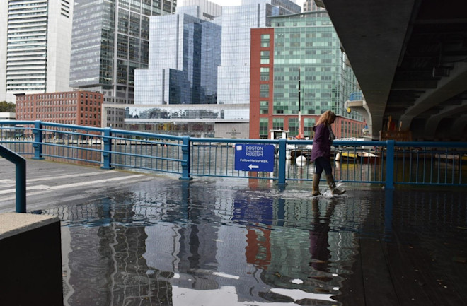
Flooding on the Boston Harborwalk from a Wicked High Tide event in October 2019.
(Credit: Janine Myszka)

From DiscoverMag by Sra Benson, David Sittenfeld, Caroline Nickerson

King tides happen when the Earth, Sun and moon align, sometimes creating "sunny day flooding." 
To understand how sea level rise will change future flood patterns, researchers and citizen scientists are teaming up to map areas that are already impacted.

Wicked high tides, also known as king tides or astronomical high tides, are a natural phenomenon that occurs several times a year in certain areas around the globe.
In the Boston area, these events usually happen in March and October.
This is when there is a full or new moon, and the Earth, Sun and moon align to create an extremely high tide.
These events are often associated with greater flooding, sometimes called “sunny day flooding” or “nuisance flooding.”
These floods happen regardless of storms or precipitation and can cause roads, sidewalks or certain areas to be impassable.

If these events already occur naturally, what can we do about them? Wicked high tide events give us a glimpse into what our future will look like as sea levels rise under climate change.
Learning exactly what areas are already flooding will help resiliency planners know where to focus their efforts in minimizing sea level rise in their communities.

Today, 40 percent of the American population lives near a coast.
Flooding events can cause major social, economic and environmental impacts by interrupting businesses, damaging transportation, buildings and the coastal environment.
High tide flooding has increased in the U.S.
on average by about 50 percent compared to 20 years ago and 100 percent compared to 30 years ago.
In Massachusetts, for example, sea levels have already risen eight inches since 1950.
The rise in sea levels makes tidal flooding and coastal erosion more likely, and further increases the risk to coastal communities from storm surges due to hurricanes.


High tide flooding events have increased around the U.S., but especially so on the East Coast.
(Credit: NOAA)

What is the Wicked High Tides program?

SciStarter, Northeastern University, NISE Network, Arizona State University and Museum of Science, Boston are working together on a National Oceanic and Atmospheric Administration-funded project to educate and engage the public in climate hazard resilience planning.
This includes engaging participants with citizen science, deliberative forums and civic action.

The projects connect the general public to various climatic hazards by allowing them to participate in climate resilience planning in their communities and introduces citizen science projects related to each hazard.
Engaging participants in citizen science activities allows community members to understand, learn and contribute meaningful data to projects centered around climate resilience.

In the summer of 2019, MOS studied the impact of extreme heat and the urban heat island effect through citizen science.
Nicknamed “Wicked Hot Boston,” the pilot year recruited members of the general public to participate in the ISeeChange project and urban heat mapping and then asked them to share their experiences and potential solutions.
The program’s success inspired other, similar programs focused on environmental hazards, such as Climate-Conscious Durham with the Museum of Life + Science in Durham, North Carolina.

In the second year of the project, the MOS team focused on the extreme hazard of sea-level rise with the catchy nickname “Wicked High Tides.” In 2020 and 2021, the project involves the citizen science projects MyCoast and ISeeChange.

MyCoast invites participants to document tides, storm damage, beach cleanups and more via their app, and ISeeChange asks citizen scientists to investigate how weather and climate change impact their lives and community by sharing photos and stories about multiple hazards, including sea-level rise.
In addition, the project involved a webinar and two deliberative forums; one in person and one online.

Discover both ongoing projects on SciStarter’s Museum of Science, Boston microsite.


In this sea-level rise forum board game, participants work as a group to come up with a resilience plan based on background information, stakeholder perspectives and values, and different resilience plan options.
Participants work through the steps with the help of a table facilitator.

What is Citizen Science?

Citizen science is public engagement in real scientific research, most often by collecting data or analyzing data for ongoing research projects.
SciStarter connects a community of over 100,000 citizen scientists with thousands of different projects spanning astronomy, health, biodiversity and everything in between.

Via the portals on SciStarter.org/NOAA, SciStarter works with the museums and science centers, as well as the project leaders for featured projects, to walk patrons through the process of engaging in an ongoing environmentally-focused citizen science project to better understand a particular climate hazard.
The goal is to introduce them to a forum or another event for further engagement.

Wicked High Tides Forum

All citizen scientists who participated in ISeeChange and MyCoast via the Museum of Science, Boston’s SciStarter microsite were invited to participate in a climate hazard resilience forum on sea-level rise.
The first forum was held in person on March 3, 2020, and the second forum was held online due to Covid-19 on November 10, 2020.

Forum programs engage participants in deliberative, inclusive conversations about issues that lie at the intersection of science and society.
These programs allow Museum visitors, scientists and policymakers to share their perspectives and learn from one another.

This project uses the climate hazard resilience forums, and the goal of the forums is to explore potential vulnerabilities to city infrastructures, social networks and ecosystems from sea level rise, extreme precipitation, drought and extreme heat, then discuss potential strategies for addressing these threats.
Participants learn and discuss stakeholder values, consider the trade-offs of various resilience strategies, make a final resilience plan, and then view an interactive StoryMap that visualizes how their plan will affect the city and the people who live there.


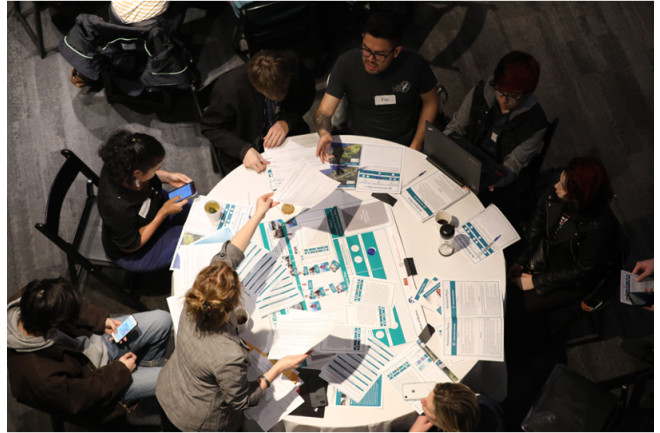
An in-person sea-level rise forum on March 3, 2020, at the Museum of Science, Boston.
(Credit: Eric Workman)


Snehal Pandey, a student from the Berklee College of Music, attended the in-person event and said it would change the conversations that she had with friends.
Her classmate, Nathhania Pasila, a freshman pianist from Jakarta, echoed the sentiment.
She said the event opened her eyes, because she didn’t realize that there were multiple ways and equally valid choices about how to manage water.
From her perspective as a musician, Pasila thought she could use her platform as a way to “treat the planet better.”

Once the tables were done discussing the resilience strategies they would implement in the anonymized Town of Kingtown, they turned their attention to the front of the room where Julie Wormser, the Deputy Director of Mystic River Watershed Association gave a presentation on how sea level rise affects the Boston area and what resilience strategies have been, or are going to be, employed in Boston to mitigate sea level rise.
Finally, the participants were able to talk to eight local community groups who work daily on sea level rise issues about how to be part of the solution.

Reverend Vernon K Walker, a participant in the project and collaborator with the Museum of Science, Boston forum team in both the extreme heat and the sea level rise projects, is an organizer of Communities Responding to Extreme Weather.
He attended the in-person forum event.
Walker’s organization fosters resilience hubs, places where people can take refuge from climate impacts, and provides other services related to resilience — for example, cooling centers in the summertime, emergency preparedness kits for flooding.
“We’re a statewide organization, and we know that there is going to be more in-land flooding,” said Walker.
“Projects like this prove the point that this is going to get worse with climate change.
It’s critical that this information is captured.”

This work is still ongoing. Over 20 sites across the United States have been accepted to receive a stipend to implement the NOAA-funded Citizen Science, Civics, and Resilient Communities (CSCRC) project between March and September 2021.This program model will increase resilience to extreme weather and environmental hazards through citizen-created data, local knowledge and community values.

And thanks to NOAA Grant NA15SEC0080005, more than just museums and science centers are using the free forum materials.
Brittney Beck, Assistant Professor of Education at California State University, Bakersfield, used the forum materials with a group of educators, who were exploring new resources for their students.
“As I facilitated each phase, I noticed their conversations became increasingly nuanced,” she said.
“The teachers transitioned from talking about sea-level rise in abstraction to engaging in an intense, interdisciplinary debate regarding how to address it.”

After the Forum facilitated by Beck, one teacher reflected, “I knew about the potential of sea-level rise, but I never had an emotional reaction to it until now.
I want to empower students to do something about climate change.”

The 20+ museum and science center sites will participate in citizen science projects and climate hazard resilience forums over the next year.
If you are close to any of these host institutions, we encourage you to participate in citizen science and attend a “Climate Hazard Resilience” Forum near you.
And no matter where you are in the world, you can study environmental impacts with citizen science and take part in one of the open, online forums.
Stay up to date on all the projects at SciStarter.org/NOAA.

Tuesday, October 5, 2021

Elbow grease and tech: fighting the plastic crisis


 From BBCEarth by Zoe Cormier

A new old-fashioned solution to the plastic crisis.

There is no corner on Earth where we will not find plastic trash – no matter how remote.
 
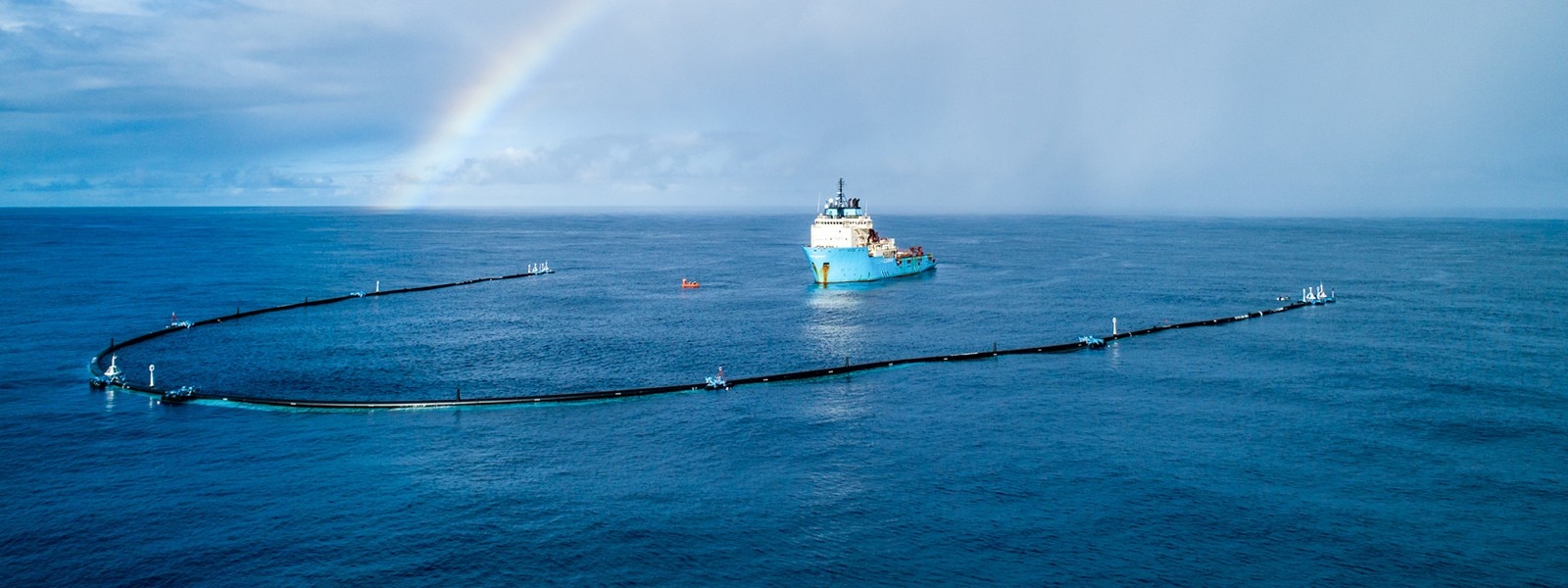
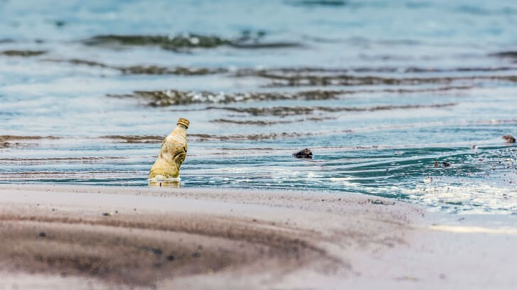
Because plastics were explicitly designed to stay intact forever, it doesn’t disappear, even when we can’t see it. 
© Puneet Vikram Singh

On the slopes of the Himalayas, on the beaches of the uninhabited Henderson Island in the south Pacific, even Antarctica isn’t spared.
And nowhere is plastic more of a headache than the oceans.

While litter picking on land is fairly straightforward, once plastic gets into the deep ocean it is a nightmare to remove.
Plastic has even been found in the deepest point on Earth, the Mariana Trench, 11,000m below the surface.
An estimated 8 million metric tonnes of plastic waste enters the world’s oceans every year – where it stays forever.

More than just an eyesore and a worry, this trash can be deadly to wildlife across the globe: bags, bottle caps, pen shafts and more are routinely found in the stomachs of dead seabirds, turtles, fish and even whales.
In November 2018, a sperm whale washed up dead on the shores of Indonesia with bottles, bags, flip flops and even 115 cups in its stomach.

Because plastic was explicitly designed to stay intact forever, it doesn’t disappear, even when we can’t see it.
Plastic breaks down into smaller and smaller pieces, finally becoming “microplastics” that can be ingested by plankton and other tiny organisms which are then eaten by larger creatures sending those tiny plastic particles onwards and upwards through the foodchain – including humans.

As we are faced with the seemingly impossible task of cleaning up our plastic mess, there is one solution that shouldn’t be overlooked: the old fashioned plastic pick up.
A number of inventors and entrepreneurs are taking on the challenge at scale.

Cleaning harbours of plastic

The first place to start is the world’s harbours and bays – especially in urban areas, where most oceanic plastic pollution starts.
It’s estimated more than 90 per cent of the plastic in seas gets there through just 10 of the world’s major rivers.
In Japan, officials are starting to experiment with huge nets over sewer pipe outlets, which appears to be having some success – but there’s still all the trash in the world’s harbours to take care of.

A team in Australia have designed Seabin, a bucket that uses a solar powered pump to siphon water and trash by bobbing up and down with a cleverly designed lid which prevents fish and other sea life from falling in.
The bins have a ravenous appetite.
Based on field tests, each bin can gather 1.5 tonnes of waste a year.
After years of development, the first commercial Seabin became available for sale in May 2018 – now they’ve taken over 400 orders from 93 countries across the globe.
The problem won’t go away until we get on top of the source of the problem"
David Turton Facilitaor, Seabin project
“We’d love to be able to put ourselves out of business, but the problem won’t go away until we get on top of the source of the problem,” says David Turton of the Seabin Project.
“In the meantime we are just trying to do our best to stop trash from getting into the open ocean.”

The Seabins aren’t the only way to gather up near-shore plastic waste.
Turton is a fan of the WasteShark, autonomous drones modeled on whale sharks that can skitter around a city harbor swallowing up trash.
“There is no one answer that will solve this huge problem – the global cleanup will need many ideas and many inventions,” says Turton.

Baltimore’s Mr Trash Wheel, an enormous solar-powered paddle-wheel contraption, hauls trash into the mouth of a googly-eyed, cartoonish waste collector.
Its appetite for garbage is formidable: in a single day, Mr Trash Wheel has collected 38,000 lbs of rubbish.
With the help of marketing campaign (featuring plush toys made from recycled plastic trash gathered by the wheel), the city of Baltimore has been able to raise the funds to build a second wheel, Professor Trash Wheel.
Newport Beach in California, and Honolulu in Hawaii are both on board to build their own wheel.

Unfortunately, because the wheel collects every kind of waste imaginable, it’s nearly impossible to sort the plastic – so the trash is burnt in an industrial incinerator to generate energy.
 
 
Plastics in the Big Blue

It’s hard to know just how much plastic is in the open ocean, but scientists estimate we have now dumped more than five trillion pieces of plastic into the ocean.
Due to global oceanic currents, much of it has accumulated in five enormous rotating gyres and the largest is the infamous “Great Pacific Garbage Patch” in the North Pacific Gyre.

Plastic bags, washing tubs, bubble wrap, toys, trinkets, enormous “ghost fishing nets”, entire bathtubs – you name it, it’s there.
Mostly however the plastic debris has been shredded and battered into a Sargasso of unidentifiable shreds and junk which drifts slowly in circles over an enormous patch of 1.6 million km2.

Though we’ve known about the garbage patch since 1997, nobody has had the courage to fully propose or pursue any solution.
A few ideas – nets, trawls – have been tossed around, but the sheer scale of the problem has proved intimidating to anyone who dared to think about it.

In December, a non-profit from the Netherlands called the Ocean Cleanup – led by a determined 27-year-old inventor – launched what can only be described as one of the most ambitious environmental projects in human history.
The device consists of a 600m long floating tube, called a “floater”, about 1m in diameter, with a 3m “skirt” dangling below it into the sea.Once dragged out to sea, the long tube – arranged in a U-shape – is designed to passively gather plastic into the centre through the differential speed of the plastic trash compared to the much heavier floater.
Or as the team put it: “Create a coastline where there are none.”
Boats will periodically gather up trash from within the zone inside the floater.
“The main advantage is that there are no moving parts – in engine-powered boats, 99 per cent of the maintenance is devoted to the control room to upkeep complex machinery,” says Boyen Slat, inventor of the system and founder of Ocean Cleanup.
“We aren’t burdened by any of that – the goal is to make the system flexible enough to follow the waves.”
 

It's been a week since Jenny and the crew reached the Great Pacific Garbage Patch.
In this short period of time, the crew had already experienced some ups and downs.
This is a brief report from offshore on what's been happening so far.
 
Autonomous, energy neutral (solar panels provide power to wifi enabled GPS systems) and scalable, the current system - known as System 001, nicknamed “Wilson” – is the first prototype to be deployed to the Pacific, building on testing and prototyping conducted over five years of tests in the North Sea in Europe with 67 different designs, each building on the lastEventually they hope to deploy 60 systems, which they believe could remove 50 per cent of the trash in the Pacific every five years.
Unfortunately, The Ocean Cleanup has hit a snag since launch: in the first four weeks after deployment in November, System 001 wasn’t gathering as much plastic debris into the void of the U shape as well as expected – trash would drift in, but then drift out again.But even worse, a piece of the apparatus broke on December 29 2018.
Crew discovered that one of the tow heads, together with an 18m piece of floater pipe with two stabilizer frames was drifting away from the rest of System 001.
As of March 2019, the entire system is being docked in Hawaii for repairs and modification, and the team expect to bring it back to the garbage patch in a few months.
 
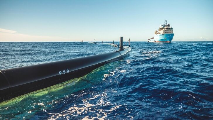
System 001 in operation in the Great Pacific Garbage Patch, November 2018.© The Ocean Clean Up
 
“To be clear, we realise that setbacks like this are inevitable when pioneering new technology at a rapid pace.
Because this is a beta system, we were expecting these sorts of things,” says Rachel Richardson, Communications Strategy Officer. 
“The plane didn’t fly on its first attempt, and the space shuttle didn’t succeed on its first attempt.
This technology is designed for a really difficult place – like air or space travel, the ocean is huge and really far away.”

It is fair to compare gathering up all the plastic trash in the seas to landing a man on the moon – and in all likelihood, it’s going to be much harder, given the size and the scale of the problem.
“There is no reason not to try,” says Slat.

Links :

Monday, October 4, 2021

Götheborg II: Replica 18th century ship plans to re-sail the trading route from Sweden to China

From CNN by Lilit Marcus

Nearly 200 years after it sank into the sea, the galleon Götheborg is retracing its path around the world.
Well, sort of.
The original Götheborg, a trading vessel that belonged to the Swedish East India Company, sank in 1745.
Despite going down in the Göta älv river near Gothenburg harbor, divers were first able to explore its wreck in the 1980s.

A full-scale replica, dubbed Götheborg II, now stands proudly in Stockholm's waters.
In April 2022, it will set sail from Sweden and begin to retrace the journey of its namesake. 
 
 
The Götheborg II towers over other boats in harbor.
Fredrik Nilsson/Courtesy Svenska Ostindiska Companiet
 
Though wind and weather conditions are always a factor, the ship's planned itinerary features stops in London, Lisbon, Palma de Mallorca, Athens, Alexandria, Djibouti, Muscat, Chennai, Singapore, Ho Chi Minh City, Hong Kong and Shanghai. 

That route requires passing through the Suez Canal, which was the site of a global soap opera earlier this year when a container ship called the Ever Given got stuck there for more than a week, blocking other ship traffic and disrupting global supply chains.

If all goes according to plan, Götheborg II will arrive in Shanghai sometime in October 2022.
Docked in Sweden, the ship currently has 80 crew members.
At each stop, new deck hands will come on and the member of crew members will grow by about 50, meaning that there should be about 600 people on board to help see the Goteborg II safely to Asia. 

"The mission for the journey is to strengthen Swedish-Asian trade relations, and promote the need for innovative solutions for a more sustainable world," a rep for the Götheborg II tells CNN.
"The expedition's aim is to bring forward Swedish innovations and businesses as an important and necessary part of the solution towards our vision of creating a sustainable future."
 
Götheborg of Sweden is the world's largest ocean-going wooden sailing ship.
 
Joining the past and the present
 
One of the challenges of re-creating the ship was finding the same kinds of wood and tools used in the 18th century.
During its lifetime, Götheborg was the world's largest wooden seafaring ship.
The team building Götheborg II didn't want their ship to be a modern interpretation -- rather, they spent time finding the correct materials and tools to build a ship the exact same way they would have two centuries earlier.
Just like its predecessor, Götheborg II is 58.5 meters (192 feet) long, 11 meters (36 feet) wide, has a vertical clearance of 47 meters (154 feet) and can reach speeds as high as 11 knots.
Altogether, it took more than a decade to complete.

The original vessel was owned by the Swedish East India Company, which was set up to establish trade between Sweden and Asian countries, primarily China.
The company was in business from 1731 until 1813 and is responsible for bringing many Chinese products, like tea and rice, to Sweden for the first time.
And the ship's name, Götheborg, was particularly fitting. Gothenburg (as it's spelled in English) is situated on Sweden's west coast, making it a perfect entry and exit point for these ships.
In the 18th century, Gothenburg thrived as a center of commerce and grew to become Sweden's second-biggest city, which it remains now.

Even today, more than 200 years later, there are still glimmers of that era in the modern, busy city.
For example, the onetime office of the Swedish East India Company is now home to the Gothenburg City Museum.
The Swedish East India Company was re-established in 1993, although with a considerably different mission.
Instead of focusing on trade, the company now works to support Sweden's shipbuilding industry.

Links :