Soul_Sailing in Croatia from Gunther Machu
Saturday, September 21, 2013
Friday, September 20, 2013
Netherlands NLHO update in the Marine GeoGarage

31 charts (64 including sub-charts have been updated with 2013 material from the Netherlands Hydrographic Office (so a total of 227 including sub-charts -see list-) :
---> see Reduced production of Dutch NLHO charts for 2013 update
- 18011 Overzichtskaart Noordzeekust De P
- 180110 Zeegat van Texel
- 180110 A Den Helder
- 18012 Noordzeekust De Panne tot Oostend
- 18012 A Nieuwpoort
- 18012 B Oostende
- 18013 Noordzeekust Oostende tot Westkap
- 18013 A Blankenberge
- 18013 B Zeebrugge
- 18014 Westerschelde, Aanloop Vlissingen
- 18014 A Breskens
- 18014 B Vlissingen
- 18015 Noordzeekust Westkapelle tot West
- 18015 A Neeltje Jans
- 18016 Noordzeekust West Schouwen tot Ho
- 18016 A Stellendam
- 18017 Noordzeekust Hoek van Holland tot
- 18017 A Scheveningen
- 18018 Noordzeekust Noordwijk aan Zee to
- 18018 A IJmuiden
- 18019 Noordzeekust IJmuiden tot aanloop
- 18092 Nieuwe waterweg, Kilometer 1031 to
- 18111 Overzichtskaart Waddenzee (Westeli
- 181110 Noordzeekust, Zeegat van Ameland
- 18112 Zeegat van Texel
- 18112 A Den Helder
- 18113 Waddenzee, Den Helder tot Kornwerd
- 18113 A Den Oever
- 18113 B Oude Schild
- 18113 C Breezanddijk
- 18113 D Kornwerderzand
- 18114 Waddenzee, Zeegat van Terschelling
- Hoofdkaart Terschelling/Vlieland
- 18115 A Aanloop Harlingen
- 18115 B Vlieland
- 18115 C West Terschelling
- 18115 D Aanloop West Terschelling
- 18115 E Aanloop Vlieland
- 18116 Waddenzee, Zeegat van Ameland tot
- 18117 Eierlandsche Gat
- 18118 Noordzeekust, Zeegat van Texel tot
- 18119 Noordzeekust, Eierlandsche Gat tot
- 18121 Waddenzee(Oost)
- 18122 Hollum tot Ternaard
- 18122 A Nes
- 18123 Schiermoog tot Lauwersoog
- 18123 A Lauwersoog
- 18123 B Schiermonnikoog
- 18124 Lauwersmeer
- 18124 A InzetA(vervolg van 1812,4)
- 18124 B Dokkumer Nieuwe Zijlen
- 18124 C Zoutkamp
- 18124 D Oostmahorn
- 18124 E Lauwersoog
- 18125 Schierm-oog tot Rottumeroog
- 18126 Schierm-oog tot Norddeich
- 18127 Eemshaven tot Knock
- 18127 A Eemshaven
- 18127 B Delfzijl
- 18127 C Termunterzijl
- 18128 Knock tot Papenburg
- 18128 A Vervolg 1812,8B
- 18128 B Vervolg 1812,8
- 18129 Frieschezeegat tot Monden v/d Eems
- 181210 Monden v/d Eems tot Norderneyer S
Note : In accordance with SOLAS, nautical products must be kept up-to-date.
The Netherlands Hydrographic Office therefore publishes Notices to Mariners (corrections on Netherlands nautical charts, small craft charts and Nautical Publications / Week edition).
Undersea mountains provide crucial piece in climate prediction puzzle
For a long time, researchers have tried to uncover how deep and mid-depth waters in the ocean near Antarctica are mixed.
They have now found that underwater mountains in the Drake Passage and other locations cause the mixing.
Video courtesy of the British Antarctic Survey
They have now found that underwater mountains in the Drake Passage and other locations cause the mixing.
Video courtesy of the British Antarctic Survey
From Exeter University
A mystery in the ocean near Antarctica has been solved by researchers who have long puzzled over how deep and mid-depth ocean waters are mixed.

Drake Passage
>>> geolocalization with the Marine GeoGarage <<<
They found that sea water mixes dramatically as it rushes over undersea mountains in Drake Passage - the channel between the southern tip of South America and the Antarctic continent.
Mixing of water layers in the oceans is crucial in regulating the Earth’s climate and ocean currents.
The research provides insight for climate models which until now have lacked the detailed information on ocean mixing needed to provide accurate long-term climate projections.
The study was carried out by the University of Exeter, the University of East Anglia, the University of Southampton, the Woods Hole Oceanographic Institution, the British Antarctic Survey and the Scottish Association for Marine Science and is published in the journal Nature.
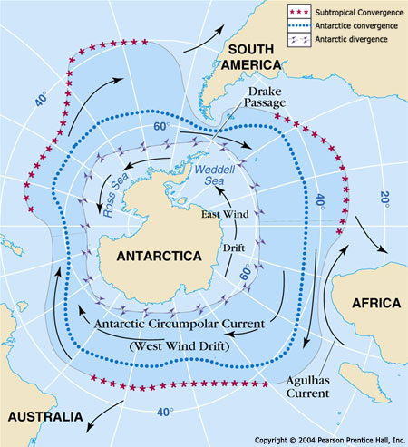
Working in some of the wildest waters on the planet, researchers measured mixing in the Southern Ocean by releasing tiny quantities of an inert chemical tracer into the Southeast Pacific.
They tracked the tracer for several years as it went through Drake Passage to observe how quickly the ocean mixed.
The tracer showed almost no vertical mixing in the Pacific but as the water passed over the mountainous ocean floor in the relatively narrow continental gap that forms the Drake Passage it began to mix dramatically.

“A thorough understanding of the process of ocean mixing is crucial to our understanding of the overall climate system. Our study indicates that virtually all the mixing in the Southern Ocean occurs in Drake Passage and at a few other undersea mountain locations. Our study will provide climate scientists with the detailed information about the oceans that they currently lack.”

Credit: Alan Homer and British Antarctic Survey
Over several hundred years this process will remove much of the carbon dioxide that we release into the atmosphere, storing it in the deep ocean.
Ocean mixing also affects climate, for example an increase in the rate of deep sea mixing would enable the ocean to transfer more heat towards the poles.
Scientists believe that the lower concentrations of atmospheric carbon dioxide present during the ice ages may have been the result of slower ocean mixing between the surface and the deep sea. Although the reasons for this are not yet clear, this further emphasises the link between ocean mixing and climate.
This research was funded by the UK Natural Environment Research Council (NERC) and the US National Science Foundation (NSF). Andrew Watson is supported by the Royal Society.
Thursday, September 19, 2013
Kings of camouflage
Cuttlefish are marine animals of the order Sepiida.
They belong to the class Cephalopoda, which also includes squid, octopuses, and nautiluses.
'Cuttle' is a reference to their unique internal shell, the cuttlebone; and despite their name, cuttlefish are true mollusks.
Cuttlefish have large, W-shaped pupils, eight arms, and two tentacles furnished with denticulated suckers, with which they secure their prey.
They generally range in size from 15 to 25 cm (5.9 to 9.8 in), with the largest species, Sepia apama, reaching 50 cm (20 in) in mantle length and over 10.5 kg (23 lb) in weight.[1]
Camouflage is the use of any combination of materials, coloration or illumination for concealment, either by making animals or objects hard to see (crypsis), or by disguising them as something else (mimesis).
Examples include the leopard's spotted coat, the battledress of a modern soldier, and the leaf-mimic katydid's wings.
A third approach, motion dazzle, confuses the observer with a conspicuous pattern, making the object visible but momentarily harder to locate.
The majority of camouflage methods aim for crypsis, often through a general resemblance to the background, high contrast disruptive coloration, eliminating shadow, and countershading.
In the open ocean, where there is no background, the principal methods of camouflage are transparency, silvering, and countershading, while the ability to produce light is among other things used for counter-illumination on the undersides of cephalopods such as squid.
Some animals, such as chameleons and octopuses, are capable of actively changing their skin pattern and colours; they often use this ability both for camouflage and for signalling.
Military camouflage was spurred by the increasing range and accuracy of firearms in the 19th century. In particular the replacement of the inaccurate musket with the rifle made personal concealment in battle a survival skill.
In the 20th century, military camouflage developed rapidly, especially during the First World War.
On land, artists such as André Mare designed camouflage schemes and observation posts disguised as trees.
At sea, warships and troop carriers were painted in dazzle patterns that were highly visible, but designed to confuse enemy gunners as to the target's speed, range, and heading.
During and after the Second World War, a variety of camouflage schemes were used for aircraft and for ground vehicles in different theatres of war.
The use of radar in the Cold War period has largely made camouflage for fixed-wing military aircraft obsolete.
Camouflaged octopus makes marine biologist scream bloody murder :
Roger Hanlon was following this octopus underwater and couldn't believe his eyes.
Non-military use of camouflage includes making cell telephone towers less obtrusive and helping hunters to approach wary game animals.
Patterns derived from military camouflage are frequently used in fashion clothing, exploiting their strong designs and sometimes their symbolism.
Camouflage themes recur in modern art, and both figuratively and literally in science fiction and works of literature.
Links :
- The Telegraph : Stealth coating based on squid skin could make soldiers invisible to night vision
Wednesday, September 18, 2013
UK & misc. update in the Marine GeoGarage
 Today 955 charts (including 1827 sub-charts) from UKHO
are available in the 'UK & misc.' chart layer
regrouping charts for different countries :
- UK
- Argentina
- Belgium
- Netherlands
- Croatia
- Oman
- Portugal
- Spain
- Iceland
- South Africa
- Malta

 24 charts for Argentina :
- 226 International Chart Series, Antarctica - South Shetlands Islands, Deception Island.
- 227 Church Point to Cape Longing including James Ross Island
- 531 Plans on the Coast of Argentina
- 552 Plans on the Coast of Argentina
- 557 Mar del Plata to Comodoro Rivadavia
- 1302 Cabo Guardian to Punta Nava
- 1331 Argentina, Approaches to Bahia Blanca
- 1332 Isla de los Estados and Estrecho de le Maire
- 1751 Puerto de Buenos Aires
- 1982B Rio Parana - Rosario to Parana
- 2505 Approaches to the Falkland Islands
- 2517 North-Western Approaches to the Falkland Islands
- 2519 South-Western Approaches to the Falkland Islands
- 3065 Punta Piedras to Quequen
- 3066 Quequen to Rio Negro
- 3067 Rio Negro to Isla Leones
- 3106 Isla Leones to Pto San Julian
- 3213 Plans in Graham Land
- 3560 Gerlache Strait Northern Part
- 3566 Gerlache Strait Southern Part
- 3755 Bahia Blanca
- 4063 Bellingshausen Sea to Valdivia
- 4200 Rio de la Plata to Cabo de Hornos
- 4207 Falkland Islands to Cabo Corrientes and Northeast Georgia Rise
 27 charts for Belgium & Nederlands :
- 99 Entrances to Rivers in Guyana and Suriname
- 110 Westkapelle to Stellendam and Maasvlakte
- 112 Terschellinger Gronden to Harlingen
- 120 Westerschelde - Vlissingen to Baalhoek and Gent - Terneuzen Canal
- 122 Approaches to Europoort and Hoek van Holland
- 124 Noordzeekanaal including Ijmuiden, Zaandam and Amsterdam
- 125 North Sea Netherlands - Approaches to Scheveningen and Ijmuiden
- 126 North Sea, Netherlands, Approaches to Den Helder
- 128 Westerschelde, Valkenisse to Wintam
- 207 Hoek Van Holland to Vlaardingen
- 208 Rotterdam, Nieuwe Maas and Oude Maas
- 209 Krimpen a/d Lek to Moerdijk
- 266 North Sea Offshore Charts Sheet 11
- 572 Essequibo River to Corentyn River
- 702 Nederlandse Antillen, Aruba and Curacao
- 1187 Outer Silver Pit
- 1408 North Sea, Harwich and Rotterdam to Cromer and Terschelling.
- 1412 Caribbean Sea - Nederlandse Antillen, Ports in Aruba and Curacao
- 1414 Bonaire
- 1503 Outer Dowsing to Smiths Knoll including Indefatigable Banks.
- 1504 Cromer to Orford Ness
- 1546 Zeegat van Texel and Den Helder Roads
- 1630 West Hinder and Outer Gabbard to Vlissingen and Scheveningen
- 1631 DW Routes to Ijmuiden and Texel
- 1632 DW Routes and Friesland Junction to Vlieland
- 1874 North Sea, Westerschelde, Oostende to Westkapelle
- 2047 Approaches to Anguilla
 13 charts for Croatia :
(683 Bar, Dubrovnik and Approaches and Peljeski Kanal
1582 Approaches to Bar and Boka Kotorska
withdrawn since the last update)
- 201 Rt Kamenjak to Novigrad
- 202 Kvarner, Kvarneric and Velebitski Kanal
- 269 Ploce and Split with Adjacent Harbours, Channels and Anchorages
- 515 Zadar to Luka Mali Losinj
- 680 Dubrovnik ADDED from last release
- 1574 Otok Glavat to Ploce and Makarska
- 1580 Otocic Veliki Skolj to Otocic Glavat
- 1996 Ports in Rijecki Zaljev
- 2711 Rogoznica to Zadar
- 2712 Otok Susac to Split
- 2719 Rt Marlera to Senj including Approaches to Rijeka
- 2773 Sibenik, Pasmanski Kanal, Luka Telascica, Sedmovrace, Rijeka Krka
- 2774 Otok Vis to Sibenik
 7 charts for Oman :
- 2853 Gulf of Oman, approaches to Sohar
- 2854 Northern approaches to Masirah
- 3171 Southern Approaches to the Strait of Hormuz
- 3409 Plans in Iran, Oman and the United Arab Emirates
- 3511 Wudam and Approaches
- 3518 Ports and Anchorages on the North East Coast of Oman
- 3762 Ad Duqm ADDED from last release
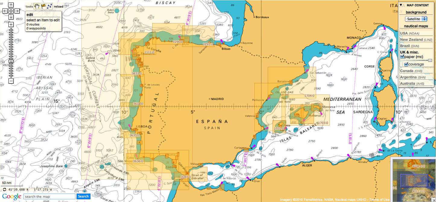
123 charts for Spain & Portugal :
- 73 Puerto de Huelva and Approaches
- 83 Ports on the South Coast of Portugal
- 85 Spain - south west coast, Rio Guadalquivir
- 86 Bahia de Cadiz
- 87 Cabo Finisterre to the Strait of Gibraltar
- 88 Cadiz
- 89 Cabo de Sao Vicente to Faro
- 91 Cabo de Sao Vicente to the Strait of Gibraltar
- 93 Cabo de Santa Maria to Cabo Trafalgar
- 142 Strait of Gibraltar
- 144 Mediterranean Sea, Gibraltar
- 307 Angola, Cabeca da Cobra to Cabo Ledo
- 308 Angola, Cabo Ledo to Lobito
- 309 Lobito to Ponta Grossa
- 312 Luanda to Baia dos Tigres
- 366 Arquipelago de Cabo Verde
- 469 Alicante
- 473 Approaches to Alicante
- 518 Spain East Coast, Approaches to Valencia
- 562 Mediterranean Sea, Spain - East Coast Valencia
- 580 Al Hoceima, Melilla and Port Nador with Approaches
- 659 Angola, Port of Soyo and Approache
- 690 Cabo Delgado to Mikindani Bay
- 886 Estrecho de la Bocayna and Approaches to Arrecife
- 1094 Rias de Ferrol, Ares, Betanzos and La Coruna
- 1096 Ribadeo
- 1110 La Coruna and Approaches
- 1111 Punta de la Estaca de Bares to Cabo Finisterre
- 1113 Harbours on the North-West Coast of Spain
- 1117 Puerto de Ferrol
- 1118 Ria de Ferrol
- 1122 Ports on the North Coast of Spain
- 1133 Ports on the Western Part of the North Coast of Spain
- 1142 Ria de Aviles
- 1145 Spain - North Coast, Santander
- 1150 Ports on the North Coast of Spain
- 1153 Approaches to Gijon
- 1154 Spain, north coast, Gijon
- 1157 Pasaia (Pasajes) and Approaches
- 1172 Puertos de Bermeo and Mundaka
- 1173 Spain - North Coast, Bilbao
- 1174 Approaches to Bilbao
- 1180 Barcelona
- 1189 Approaches to Cartagena
- 1193 Spain - east coast, Tarragona
- 1194 Cartagena
- 1196 Approaches to Barcelona
- 1197 Plans on the West Coast of Africa
- 1215 Plans on the Coast of Angola
- 1216 Baia dos Tigres
- 1290 Cabo de San Lorenzo to Cabo Ortegal
- 1291 Santona to Gijon
- 1448 Gibraltar Bay
- 1453 Gandia
- 1455 Algeciras
- 1460 Sagunto
- 1514 Spain - East Coast, Castellon
- 1515 Ports on the East Coast of Spain
- 1589 Almeria
- 1595 Ilhas do Principe, de Sao Tome and Isla Pagalu
- 1684 Ilha da Madeira, Manchico and Canical
- 1685 Nisis Venetico to Nisos Spetsai including the Channels between Akra Maleas and Kriti
- 1689 Ports in the Arquipelago da Madeira
- 1701 Cabo de San Antonio to Vilanova I la Geltru including Islas de Ibiza and Formentera
- 1703 Mallorca and Menorca
- 1704 Punta de la Bana to Islas Medas
- 1724 Canal do Geba and Bissau
- 1726 Approaches to Canal do Geba and Rio Cacheu
- 1727 Bolama and Approaches
- 1730 Spain - West Coast, Ria de Vigo
- 1731 Vigo
- 1732 Spain - West Coast, Ria de Pontevedra
- 1733 Spain - West Coast, Marin and Pontevedra
- 1734 Approaches to Ria de Arousa
- 1740 Livingston Island, Bond Point to Brunow Bay including Juan Carlos 1 Base and Half Moon Island
- 1755 Plans in Ria de Arousa
- 1756 Ria de Muros
- 1762 Vilagarcia de Arosa
- 1764 Ria de Arousa
- 1831 Arquipelago da Madeira
- 1847 Santa Cruz de Tenerife
- 1850 Approaches to Malaga
- 1851 Malaga
- 1854 Motril and Adra
- 1856 Approaches to Puerto de La Luz (Las Palmas)
- 1858 Approaches to Santa Cruz de Tenerife, Puerto de San Sebastian de la Gomera, Santa Cruz de la Palma and Approaches
- 1869 Gran Canaria to Hierro
- 1870 Lanzarote to Gran Canaria
- 1895 Ilha de Sao Miguel
- 1950 Arquipelago dos Acores
- 1956 Arquipelago dos Acores Central Group
- 1957 Harbours in the Arquipelago Dos Acores (Central Group)
- 1959 Flores,Corvo and Santa Maria with Banco Das Formigas
- 2742 Cueta
- 2761 Menorca
- 2762 Menorca, Mahon
- 2831 Punta Salinas to Cabo de Formentor including Canal de Menorca
- 2832 Punta Salinas to Punta Beca including Isla de Cabrera
- 2834 Ibiza and Formentera
- 2932 Cabo de Sao Sebastiao to Beira
- 2934 Africa - east coast, Mozambique, Beira to Rio Zambeze
- 2935 Quelimane to Ilha Epidendron
- 3034 Approaches to Palma
- 3035 Palma
- 3220 Entrance to Rio Tejo including Baia de Cascais
- 3221 Lisboa, Paco de Arcos to Terreiro do Trigo
- 3222 Lisboa, Alcantara to Canal do Montijo
- 3224 Approaches to Sines
- 3227 Aveiro and Approaches
- 3228 Approaches to Figueira da Foz
- 3257 Viana do Castelo and Approaches
- 3258 Approaches to Leixoes and Barra do Rio Douro
- 3259 Approaches to Setubal
- 3260 Carraca to Ilha do Cavalo
- 3448 Plans in Angola
- 3578 Eastern Approaches to the Strait of Gibraltar
- 3633 Islas Sisargas to Montedor
- 3634 Montedor to Cabo Mondego
- 3635 Cabo Mondego to Cabo Espichel
- 3636 Cabo Espichel to Cabo de Sao Vicente
- 3764 Cabo Torinana to Punta Carreiro
- 4114 Arquipelago dos Acores to Flemish Cap
- 4115 Arquipelago dos Acores to the Arquipelago de Cabo Verde
- Ilha de Madeira, Ponta Gorda de Sao Lourenco including the Port of Funchal

14 charts for Iceland :
- 2733 Dyrholaey to Snaefellsjokull
- 2734 Approaches to Reykjavik
- 2735 Iceland - South West Coast, Reykjavik
- 2897 Iceland
- 2898 Vestfirdir
- 2899 Iceland, Noth Coast, Horn to Rauoinupur
- 2900 Iceland, North East Coast, Rauoinupur to Glettinganes
- 2901 Iceland, East Coast, Glettinganes to Stokksnes
- 2902 Stokksnes to Dyrholaey
- 2955 Iceland, North Coast, Akureyri
- 2956 Iceland, North Coast, Eyjafjordur
- 2937 Hlada to Glettinganes
- 2938 Reydarfjordur
- 4112 North Atlantic Ocean, Iceland to Greenland

49 charts for South Africa :
- 578 Cape Columbine to Cape Seal
- 632 Hollandsbird Island to Cape Columbine
- 643 Durban Harbour
- 665 Approaches to Zanzibar
- 1236 Saldanha Bay
- 1806 Baia dos Tigres to Conception Bay
- 1846 Table Bay Docks and Approaches
- 1922 RSA - Simon's Bay
- 2078 Port Nolloth to Island Point
- 2086 East London to Port S Johns
- 2087 Port St John's to Durban
- 2088 Durban to Cape Vidal
- 2095 Cape St Blaize to Port S. John's
- 3793 Shixini Point to Port S Johns
- 3794 Port S Johns to Port Shepstone
- 3795 Port Shepstone to Cooper Light
- 3797 Green Point to Tongaat Bluff
- 3859 Cape Cross to Conception Bay
- 3860 Mutzel Bay to Spencer Bay
- 3861 Namibia, Approaches to Luderitz
- 3869 Hottentot Point to Chamais Bay
- 3870 Chamais Bay to Port Nolloth
- 4132 Kunene River to Sand Table Hill
- 4133 Sand Table Hill to Cape Cross
- 4136 Harbours on the West Coasts of Namibia and South Africa
- 4141 Island Point to Cape Deseada
- 4142 Saldanha Bay Harbour
- 4145 Approaches to Saldanha Bay
- 4146 Cape Columbine to Table Bay
- 4148 Approaches to Table Bay
- 4150 Republic of South Africa, South West Coast, Table Bay to Valsbaai
- 4151 Cape Deseada to Table Bay
- 4152 Republic of South Africa, South West Coast, Table Bay to Cape Agulhas
- 4153 Republic of South Africa, South Coast, Cape Agulhas to Cape St. Blaize
- 4154 Mossel Bay
- 4155 Cape St Blaize to Cape St Francis
- 4156 South Africa, Cape St Francis to Great Fish Point
- 4157 South Africa, Approaches to Port Elizabeth
- 4158 Republic of South Africa - South Coast, Plans in Algoa Bay.
- 4159 Great Fish Point to Mbashe Point
- 4160 Ngqura Harbour
- 4162 Approaches to East London
- 4163 Republic of South Africa, South East Coast, Mbashe Point to Port Shepstone
- 4170 Approaches to Durban
- 4172 Tugela River to Ponta do Ouro
- 4173 Approaches to Richards Bay
- 4174 Richards Bay Harbour
- 4205 Agulhas Plateau to Discovery Seamounts
- 4700 Port Elizabeth to Mauritius
- 36 Marsaxlokk
- 177 Valletta Harbours
- 211 Plans in the Maltese Islands
- 2537 Ghawdex (Gozo), Kemmuna (Comino) and the Northern Part of Malta
- 2538 Malta

5 charts for Malta :

(2 charts withdrawn from previous update
666 Port Mombasa including Port Kilindini and Port Reitz
2441 Jazireh-Ye Tonb-e Bozorg to Jazireh-ye Forur)
- 3 Chagos Archipelago
- 82 Outer Approaches to Port Sudan
- 100 Raas Caseyr to Suqutra
- 255 Eastern Approaches to Jamaica
- 256 Western Approaches to Jamaica
- 260 Pedro Bank to the South Coast of Jamaica
- 333 Offshore Installations in the Gulf of Suez
- 334 North Atlantic Ocean, Bermuda
- 386 Yadua Island to Yaqaga Island
- 390 Bahamas, Grand Bahama Island, Approaches to Freeport
- 398 Grand Bahama Island, Freeport Roads, Freeport Harbour
- 457 Portland Bight
- 462 The Cayman Islands
- 486 Jamaica and the Pedro Bank
- 501 South East Approaches to Trinidad
- 700 Maiana to Marakei
- 766 Ellice Islands
- 868 Eastern and Western Approaches to The Narrows including Murray's Anchorage
- 920 Chagos Archipelago, Diego Garcia
- 928 Sulu Archipelago
- 959 Colson Point to Belize City including Lighthouse Reef and Turneffe Islands
- 1043 Saint Lucia to Grenada and Barbados
- 1225 Gulf of Campeche
- 1265 Approaches to Shatt Al 'Arab or Arvand Rud, Khawr Al Amaya and Khawr Al Kafka
- 1450 Turks and Caicos Islands, Turks Island Passage and Mouchoir Passage
- 1638 Plans in Northern Vanuatu
- 2006 West Indies, Virgin Islands, Anegada to Saint Thomas
- 2009 Sheet 2 From 23 deg 40 min North Latitude to Old Bahama Channel
- 2065 Northern Antigua
- 2133 Approaches to Suez Bay (Bahr el Qulzum)
- 2373 Bahr el Qulzum (Suez Bay) to Ras Sheratib
- 2374 Ra's Sharatib to Juzur Ashrafi
- 2658 Outer Approaches to Mina` al Jeddah (Jiddah)
- 2837 Strait of Hormuz to Qatar
- 2847 Qatar to Shatt al `Arab
- 3043 Red Sea, Ports on the coast of Egypt.
- 3102 Takoradi and Sekondi Bays
- 3175 Jazirat al Hamra' to Dubai (Dubayy) and Jazireh-ye Sirri
- 3179 UAE and Qatar, Jazirat Das to Ar Ru' Ays
- 3310 Africa - east coast, Mafia Island to Pemba Island
- 3361 Wasin Island to Malindi
- 3432 Saltpond to Tema
- 3493 Red Sea - Sudan, Bashayer Oil Terminals and Approaches.
- 3519 Southern Approaches to Masirah
- 3520 Khawr Kalba and Dawhat Diba to Gahha Shoal
- 3522 Approaches to Masqat and Mina' al Fahl
- 3530 Approaches to Berbera
- 3709 Gulf of Oman, United Arab Emirates, Port of Fujairah (Fujayrah) and Offshore Terminals.
- 3723 Gulf of Oman, United Arab Emirates, Approaches to Khawr Fakkan and Fujairah (Fujayrah).
- 3785 Mina' Raysut to Al Masirah
- 3907 Bahama Islands and Hispaniola, Passages between Mayaguana Island and Turks and Caicos Islands.
- 3908 Passages between Turks and Caicos Islands and Dominican Republic
- 3910 Little Bahama Bank including North West Providence Channel
- 3912 Bahamas, North East Providence Channel and Tongue of the Ocean
- 3913 Bahamas, Crooked Island Passage and Exuma Sound
- 3914 Turks and Caicos Islands and Bahamas, Caicos Passage and Mayaguana Passage
- 3951 Sir Bani Yas to Khawr al `Udayd
So today, for a cost of 9.9 € / month ('Premium Charts' subscription), you can have access to 2588 additional updated charts (4332 including sub-charts) coming from 3 international Hydrographic Services (UKHO, CHS, AHS and France).
Port security goes geospatial

Photo: An Example Geospatial user Interface
From TheMaritimeExecutive (by Eric Olson)
Everything is going geospatial - Amazon, Google, Facebook, Pinterest. Geospatial is defined as relating to data that is associated with a particular location.
In security terms, that means WHAT happened and WHERE did it happen.
So how does a geospatial surveillance system provide value to a seaport?
One of the biggest advantages of a geospatial system is it provides a high level of situational awareness.
Geospatial systems allow for a map-based representation of security sensors.
A user can view the GUI and quickly gain an understanding of the current state of events on one interface.
This includes the ability to dynamically show an intrusion event including the target location and the associated track.
A geospatial system also provides for user interaction through this same interface.
This means sensors can be queried and controlled by interaction with a map based display.
Sensors that can be used to interrogate or react the event, such as fixed cameras, PTZ cameras, acoustic devices, spotlights can be controlled from the GUI, using the animated intrusion track as means to direct the sensors to the exact location.
Geospatial sensors form the backbone of these systems and include radars, GPS and smart phones.
These sensors provide a large amount of data including time based location, speed and even acceleration.
There are, however, other sensors that can be enabled to be geospatial.
Fence intrusion systems can provide linear location along the fence line and cameras can be made into “visual-radars” through a pixel-to-terrain mapping process called “geo-referencing."
PTZ cameras, laser illuminator, spotlights, range finders and acoustic devices, can also be enabled to be geospatial, allowing them to be monitored and controlled using latitude and longitude information.

Another advantage of a geospatial surveillance system is the ease that sensors can share and collaborate information.
Geospatial sensors share a common operating picture, mainly a physical coordinate system.
This means they can effectively communicate with each other using a common geospatial command set.
This allows the system to easily automate many tasks that previously required operator control:
- Steering cameras to other sensor detections
- Fusing data and tracks from multiple sensors
- Automatically tracking targets and other assets
The ability to assign locations to events carries over into alarm searches and forensic efforts.
Each alarm contains location information so events may be investigated and reviewed based on a region or location, versus trying to identify specific sensors that were involved.
This can be extremely helpful when investigating specific incidents or looking at trends.
Geospatial surveillance systems also have the ability to perform a full map based, scenario replay; essentially replaying everything that that operator was seeing on the screen, including alarms, sensor positions and map locations.
At any point the reviewer can drill down to get the detailed data associated with the event or sensor.
Geospatial is here to stay and the complexity of the seaport environment makes the use of these systems something to be strongly considered to effectively address many of the related security needs.
Tuesday, September 17, 2013
Stricken Costa Concordia ship set upright in Italy
Time lapse of Costa Concordia salvage operation
From BBC
Engineers in Italy have
succeeded in setting the cruise ship Costa Concordia upright, 20 months
after it ran aground off the island of Giglio.
They said that the unprecedented salvage effort "reached degree zero [vertical], which was our target".
In the operation that took all of Monday and most of the
night, they used cables and metal boxes filled with water to roll the
ship onto a platform.
The Costa Concordia capsized in January 2012, killing 32 people.
The bodies of two of the victims of the disaster, by the
island of Giglio, have never been found.
There are hopes that they may
be located during the operation.


Pleiades 1A CNES image (17/09/2013)
'Double Titanic'
The ship was declared completely upright shortly after 04:00 local time (02:00 GMT) on Tuesday.
Franco Gabrielli, the head of Italy's Civil Protection
Authority, said the vessel was now sitting on a platform built on the
sea bed.
"A perfect operation, I must say," said Franco Porcellacchia,
leader of the technical team for Costa Cruise, the owner of the ship.
He added that no environmental spill was detected so far.
"I think the whole team is proud of what they achieved
because a lot of people didn't think it could be done," said salvage
master Nick Sloane - but he added "it's not over yet".
When the vessel was finally righted in the early hours of Tuesday morning, there was a giant cheer
from people gathered at Giglio harbour, says the BBC's Matthew Price,
and rescue workers have been out celebrating with coffees.
As daylight broke, the now-upright, brown hulk of the ship
was visible - its hull muddy and crushed from 20 months spent submerged
on its side.

Booms and nets were put in place before the operation started - to
combat any pollution threat in what is a marine national park.
The 114,000-gross tonnage ship - twice as heavy as the
Titanic - was on Monday raised from rocks on which it had been lying and
roll up onto her keel.
More than 50 enormous chains and winches were used to break the ship away from the reef - the process known as parbuckling.

During the marathon operation, the ship could be seen slowly emerging from the water.
The engineers had originally planned to complete the
operation by Monday evening, but it had to be delayed by three hours
because of a storm.
The procedure was carried out very slowly to prevent further
damage to the hull, which spent months partially submerged in 15m (50ft)
of water and fully exposed to the elements.
Officials now plan to fully inspect the vessel and begin to
prepare the next stage - the effort to repair and refloat it and
eventually tow it away to be destroyed.
Engineers have never tried to lift such a huge ship - over 951 feet long (290m) - before.

As the ship became visible at dawn following
the "perfect" operation, the damage done to the hull after spending 20
months crushed under the weight of the ship was plain to see

This is one of the most daunting and complex
salvage operations ever undertaken.
"A lot of people didn't think it
could be done," said salvage master Nicholas Sloane.

A 500-strong team of divers
and engineers have spent much of the past year stabilising the ship and
preparing for this phase.
Huge cost
Five people have been convicted of manslaughter over the
disaster.
The captain, Francesco Schettino, is currently on trial
accused of manslaughter and abandoning ship.
Giglio mayor Sergio Ortelli earlier said that
the removal of the Costa Concordia would bring an end to "a huge problem
that we have in our port and that we want to solve as soon as we can".
"Islanders can't wait to see the back of it," he said.
The small island's economy depends hugely on tourism and the presence of the wreck has discouraged visitors.
The salvage project has so far cost more than 600m euros
($800m; £500m) and is expected to cost much more before the operation is
complete.
Links :
Links :
- TheIndependent : Costa Concordia salvage: Ship pulled upright damage from tragic capsize emerges
Monday, September 16, 2013
Costa Concordia salvage begins: Will it stay in one piece during righting?
Live coverage (Reuters) : Costa Concordia Salvage Operation Begins
From CNN
Delayed by three hours because of strong thunderstorms, the unprecedented operation of salvaging the massive Costa Concordia cruise began Monday morning off the coast of Italy, near the island of Giglio.
The giant vessel ran aground and tipped over in January 2012, killing 32 of the 4,200 people on board.
Righting the ship could
take up to two days, but engineer Sergio Girotto said he's an optimist,
expecting the operation to take about 12 hours.
"I don't think we will continue into the night," he said. "After we start pulling, we should see something."


port of Giglio
The Process
It sounds counterintuitive, but in order to salvage the Costa Concordia, crews will sink portions of it deeper underwater.
The ship will then be
pulled off the seabed and rotated onto giant platforms 30 meters below
the water level.
Areas of the ship that have been dry for months will be
submerged and filled with water.
It's a process known as "parbuckling," and it's become a household term in Giglio, the tiny island that was transformed when the Costa Concordia ran aground off its coast in January 2012.
A ship this large and this heavy -- weighing 114,000 tons -- has never been parbuckled before.
Normally, crews would blow up the ship or take it apart on site.
But officials say that's
not an option with the Costa Concordia, because the ship is filled with
toxins, and because there are two bodies still believed to be either
trapped between the ship and its rocky resting place or somewhere deep
in the ship's hollow hull.

Waiter, passenger still missing
The two missing victims from the cruise ship disaster are Russel Rebello of India, and Maria Grazia Trecarichi of Sicily, Italy.
Rebello, 33, was a cruise waiter who was last seen helping passengers off the ship.
Trecarichi was on the
cruise to celebrate her 50th birthday with her 17-year-old daughter, one
of thousands of people who survived the deadly shipwreck.
On Monday,
her daughter and husband will watch crews try to rotate the ship and,
hopefully, find Trecarichi's remains.
Technicians and salvage managers from all over the world will be watching closely to see what goes wrong and what works.
"It will set the new standard for maritime salvage," Giovanni Ceccarelli, the project's engineering manager, told CNN.
Hundreds of people and
dozens of companies have collaborated on the preparations, but the
parbuckling will come down to 12 people, including the salvage master
and specialized technicians, who will be guiding the operation from
inside a prefabricated control room set up on a tower on a barge in
front of the ship.
A complex operation
Parbuckling, or righting, the ship could be done in a day or so -- provided the weather conditions agree.
So far, they seem to be, officials said on a website tracking the operation.
So far, they seem to be, officials said on a website tracking the operation.
It's a major turning point in a salvage operation that has cost the Costa Crociere company, owned by American firm Carnival Cruises, more than $600 million -- so far.
Tall towers anchored
onto the rocky shoreline between the ship and the island have been
fitted with computer-operated pulley-like wheels.
As the rotation begins,
the wheels will guide thick cables and chains pulling the middle third
of the ship from under its belly toward Giglio island.
At the same time, more
chains and cables attached to hollow boxes that have been welded onto
the ship's port side will pull the ship from the top toward the open
sea.
After about four to six
hours, the pulleys and cables will be rendered useless as gravity takes
over and the ship essentially finishes the process, relying on the
buoyant boxes alone to control the speed at which it rights itself.
Technicians will pump
compressed air into the boxes to control the water levels, which will
create buoyancy to slow the ship's rotation until it eventually comes to
rest on makeshift "mattresses" put in place on the steel platforms.
If all goes well, the
ship will lift off the rocks in one piece and not separate or break
apart.
If things go wrong, it could be disastrous.
If things go wrong, it could be disastrous.

Toxins, other items onboard
The ship contains a mix
of toxins that would be devastating for the environment if leaked into
the water, which would happen if the ship breaks apart or sinks.
According to the Costa
Concordia's inventory list published in the Italian press and confirmed
by Costa, thousands of liters of thick lubricants, paints, insecticides,
glue and paint thinners were on board before it set sail three hours
before it crashed.
There are also 10 large tanks of oxygen and 3,929 liters of carbon dioxide.
That's not all.
Refrigerators filled with milk, cheese, eggs and vegetables have been closed tight since the disaster.
And the freezers that
have not burst under the water pressure are still locked with their
rotting thawed contents sealed inside, including 1,268 kilograms of
chicken breasts, 8,200 kilograms of beef, 2,460 kilograms of cheese and
6,850 liters of ice cream.
What's next
As the ship rotates,
much more water will enter the ship than will spill out, salvage
operators say. That fresh seawater will dilute some of the toxic mix,
but it will all eventually have to be purified and pumped out before the
ship is towed across the sea for dismantling at its final port -- a
location that remains to be determined.
In the meantime, the
salvage operators have set up two rings of oil booms with absorbent
sponges and skirts that extend into the water to catch any debris that
may escape.
Once the ship is upright, it will be months before the contents are removed, likely not until it reaches its final port.
At that time, Costa
officials say they intend to remove personal effects from the state
rooms and return those to each passenger, no matter how soggy the
contents might be.
None of that is expected to happen before next
summer.
Meanwhile, captain
Francesco Schettino, who misguided the ship off course, faces charges of
manslaughter, causing a maritime disaster and abandoning ship with
passengers still on board.
His trial resumes in Grosseto on September
23.
A turning point
Once the ship is upright, the salvage operation changes dramatically.
A tiny robotic submarine
with surveillance cameras will survey the damaged side of the ship and
create the models they need to plan for the next phase of operations.
"It will look like a high-impact car accident when it is lifted," Nick Sloane, the salvage master, told CNN. "It won't be pretty."
For days, salvage
workers have been running simulations and testing their equipment.
A
steady hum of machinery out on the wreckage site could be heard night
and day in Giglio harbor.
The ship looks nothing like it did months ago, when it seemed gigantic against the tiny island.
Now giant cranes, barges and generator towers dwarf the wreckage.
Success or failure, no matter what happens on Monday, the Concordia will never again look the same.
5 convicted over deadly shipwreck in Italy
Links :
Links :
- BBC : Costa Concordia salvage operation begins
- Blog GeoGarage
Sunday, September 15, 2013
How to update your Admiralty standard nautical charts
How to update your ADMIRALTY Standard Nautical Charts (BA paper charts) using the ADMIRALTY Notices to Mariners service.
This is the entire series of film examples which can be found on the Admiralty YouTube channel, as one 27 minute film.
Notices to Mariners can be downloaded from here:
http://www.ukho.gov.uk/nms
or a searchable service with customised PDF results can be found here:
http://www.ukho.gov.uk/nmwebsearch
Image of the week : the Basque Country corniche

Basque corniche : from Hendaye to Saint Jean de Luz

Corniche basque


Baie de Loya
>>> geolocalization with the Marine GeoGarage <<<
Subscribe to:
Posts (Atom)