Saturday, September 24, 2022

Here’s what it looks likeinside hurricane Fiona

The footage was captured Thursday more than 300 miles southwest of Bermuda.
 
 
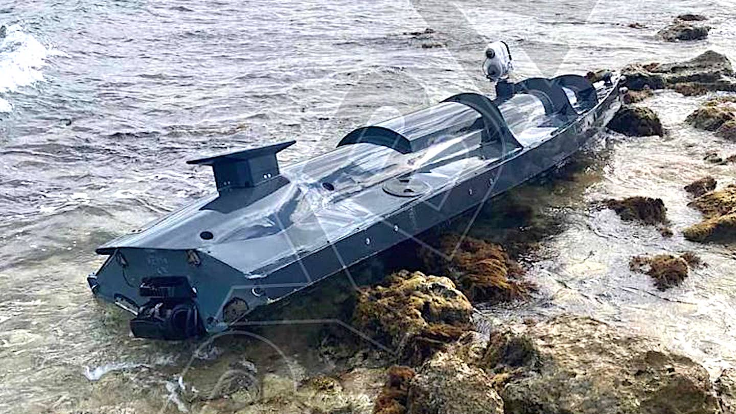
For the second year, the National Oceanic and Atmospheric Administration (NOAA) and Saildrone are hurricane chasing with uncrewed wind-powered vehicles.
 
Saildrone Explorer SD 1078 was directed into the midst of Hurricane Fiona, which is currently on a path northward in the Atlantic Ocean and is predicted to impact Bermuda on Thursday night and the Canadian province of Nova Scotia on Friday. 

Hurricane Fiona is the first Category 4 storm of the 2022 season. SD 1078 is battling 50-foot waves and winds measured over 100 mph to collect critical scientific data and, in the process, is providing a completely new view of one of Earth’s most destructive forces.

Inside the storm, SD 1078 is sailing at sustained speeds over 9 mph. At one moment, it reached a peak speed of 39.7 mph before surfing down a massive 55-foot wave.

SD 1078 is one of seven “hurricane” saildrones that have been operating in the Atlantic Ocean and Gulf of Mexico during this hurricane season, gathering data around the clock to help understand the physical processes of hurricanes.
This knowledge is critical to improving storm forecasting and is expected to reduce the loss of human life by enabling better preparedness in coastal communities.

“Saildrone is once again demonstrating its ability to provide critical ocean data in the most extreme weather conditions. Hurricane Fiona intensified from a tropical storm to a Category 1 hurricane just before hitting Puerto Rico, causing significant damage and loss of life,” said Richard Jenkins, Saildrone founder and CEO. “The data Saildrone vehicles are gathering will help the science community better understand rapid intensification, giving people living in our coastal communities more time to prepare.”

Saildrone provides data directly to NOAA’s Pacific Marine Environmental Laboratory (PMEL) and Atlantic Oceanographic and Meteorological Laboratory (AOML), Saildrone’s partners in this mission.

The seven saildrones are a part of a larger NOAA endeavor to understand hurricane intensification. NOAA also has underwater gliders, surface drifters, profiling floats, and aerial assets to collectively gain deeper insight than ever before into the development of hurricanes.
NOAA Hurricane Hunter aircraft and weather buoys gather an array of operational weather observations that are essential to hurricane forecasts.

“Uncrewed systems in the air, on the ocean surface, and underwater have the potential to transform how NOAA meets its mission to better understand the environment,” said Capt. Philip Hall, director of NOAA’s Uncrewed Systems Operations Center, which is providing funding for the Saildrone effort. “These exciting emerging technologies provide NOAA with another valuable tool that can collect data in places we can’t get to with other observing systems.”

SD 1078 is the fourth Saildrone USV to engage with Hurricane Fiona.
It was still a tropical storm when it passed over SD 1083, stationed 400 nm east of Montserrat; the vehicle measured wind speeds gusting over 40 mph.
The storm continued on a trajectory due west and had strengthened to a Category 1 as it passed over SD 1031, stationed just south of Puerto Rico, where Fiona first made landfall.
The vehicle recorded waves up to 46 feet high and wind speeds over 70 mph, which dropped abruptly to as low as 10 mph when SD 1031 was in the eye of the storm.
While inside the eye, SD 1031 recorded a minimum central pressure of 986 mb.
Stationed north of Puerto Rico, SD 1040 recorded wind speeds over 60 mph and 40-foot waves on the edge of the storm.
The data collected by the multiple Saildrone USVs interacting with Hurricane Fiona will provide invaluable information to help better understand the formation of these deadly weather systems.

This is the second video footage Saildrone has released from inside a major hurricane: Last year, SD 1045 spent 24 hours inside Category 4 Hurricane Sam, sending back high-resolution video and images in near real time.
SD 1045 made history when it sailed into Hurricane Sam, but in fact, all five vehicles in the 2021 mission contributed important insight into hurricane rapid intensification by sampling near other tropical storms—Fred, Grace, Henri, Mindy, and Peter.  

Friday, September 23, 2022

Mystery drone boat washes up near home of Russia’s Black Sea fleet


From TheDrive by Joseph Trevithick


Russian authorities on the occupied Crimean Peninsula claimed to have destroyed an unmanned surface vessel, or USV, near the city of Sevastopol, which is home to the headquarters of the Russian Navy's Black Sea Fleet.
Pictures showing what could be the maritime drone in question, which has a number of features that could point to being an uncrewed explosive-laden suicide boat, washed up on a beach have emerged on social media.
A Russian Navy Project 775 Ropucha class large landing ship, examples of which are known to be stationed in Sevastopol, is seen in the background of one of the images, lending further credence to the reports they were taken near the city.
 

Based on the pictures of the drone boat that have appeared online so far, which are seen below, it appears to be a relatively small, low-profile, and shallow-draft design with what looks like a single small waterjet drive system.
There is what appears to be a multi-camera sensor system mounted on top of the middle of the USV's hull.
A square-ish shaped flat object, which some have noted looks similar in some broad strokes to a SpaceX Starlink satellite internet antenna, is seen on top of the boat toward its stern, which could be an antenna connected to a communications/data-sharing suite.
What may be a smaller camera on top of the bow, as well as two small domes right at the prow, could be part of the USV's navigation system, be additional sensors, or have other purposes.


Via Twitter

Altogether, from what we can see immediately, the USV could be configured for surveillance and reconnaissance-type missions.
Ukrainian special operators are known to be conducting waterborne raids in southern Ukraine, among other areas.
So, this drone boat could provide valuable information about a target area before a mission, offer additional situational awareness while it is being conducted, and help with the post-mission damage assessments.

With all this in mind, it is interesting to remember that "unmanned coastal defense vessels" were part of a military aid package for Ukraine that the Pentagon announced back in April.
The War Zone has reached out to the U.S.
Department of Defense again for more information about those USVs, but American officials have declined to provide any details in the past.

"It's an unmanned surface vessel that can be used for a variety of purposes in coastal defense.
I think I'll just leave it at that," was all then Pentagon Press Secteray John Kirby would say at a briefing on April 13.
Surveillance and reconnaissance capabilities would certainly be in line with a coastal defense mission set.

However, it is not possible to rule out that the USV seen in the pictures that popped up on social media today might be entirely unrelated to the U.S-supplied USVs and have other capabilities.
In fact, it has a number of features that could point to it being more of a weapon than a surveillance and reconnaissance platform.
For instance, some observers have suggested that the two domes at the prow of USV, which could itself be based on a commercial motor canoe design, might be contact detonators that set off an explosive change after it hit a large object, such as an enemy ship.
The sensor on the bow may be a laser range finding system to help gauge the distance to the target.

Ukrainian forces have already demonstrated their ability to turn commercially available drones into impromptu cruise missiles.
it would not be surprising that there is interest in Ukraine in a broadly similar maritime capability, something that Iranian-backed Houthi militants in Yemen long ago proved is very feasible even for non-state actors to acquire an employ.

Earlier, an explosion occurred on the waters of the Black Sea, not far from Sevastopol.
Although some reports claimed that it was a controlled detonation of a sea mine, speculations have emerged that the appearance of a USV might be in some way connected to the blast.
 
Explosive-filled USVs would given Ukraine's armed forces a valuable additional tool for attacking Russian warships and other smaller watercraft, especially when it comes to targets that might be outside of the range and/or engagement envelope of ground-launched anti-ship missiles like the domestically-developed Neptune or the U.S.-made Harpoon.
A low-profile, shallow-draft design with a waterjet to give it a relatively fast top speed could be well suited to attacks on targets inside heavily defend port areas, like Sevastopol, too.

While the exact circumstances of how the drone boat came to be on the beach are unclear, the Russian governor of Sevastopol did say earlier today in a post on social media that a USV had been destroyed after being detected near the city.
That followed reports of an explosion in the Black Sea just off the coast.
There have been subsequent reports that the blast was the result of a controlled detonation of a naval mine, which are certainly real threats in the region at present, but this remains largely unconfirmed.
At the time of writing, there are no clear indications one way or another that the blast and the beached USV are in any way related, or that this is the drone boat that authorities said was destroyed.

Regardless, it's no secret that the Ukrainian military has actively targeted Sevastopol, and elements of the Russian Navy's Black Sea Fleet in particular.
There have been multiple drone strikes on Black Sea Fleet facilities in Sevastopol in recent weeks.

Crimea as a whole has been subjected to an increasing number of significant attacks in the past two months or so, including what Ukrainian authorities say were missile strikes that devastated Saki Air Base just to the north of Sevastopol in August.
Just this week, it emerged that the Russian Navy looks to have relocated its Kilo class submarines from Sevastopol to bases on the Black Sea coastline of Russia proper, likely amid concerns about how close Ukraine's forces are getting to the Peninsula as they could push ahead with their southern counter-offensive.

It remains to be seen what additional details may now emerge about this USV.
If nothing else, it reveals the existence of a previously unknown uncrewed platform with multiple potential uses that Ukrainian are using in their ongoing fight against invading Russian forces.

Update 4:25 PM EST:

Russian authorities are now saying that the USV that washed up on the beech near Sevastopol, or at least a part of it, was towed back out to sea and blown up, and that this was the blast that was observed off the coast.
“A part of an unmanned vehicle was discovered, which was examined by experts," Sevastopol Governor Mikhail Razvozhaev said, according to local media reports.
"After the survey was completed, this apparatus was destroyed at sea by an explosion.
No one was hurt."

That the drone boat was destroyed in a controlled detonation at sea would seem to indicate that it was carrying explosives, or at least that the Russians were worried that it might have been.
This, in turn, could lend additional credence to the USV being a suicide drone boat.

Links :


Thursday, September 22, 2022

Behind each map, a story. The cartography of the Strait of Magellan between science and imagination

Antonio_Pigafetta_Magellanstrasse_1520
 
From CartoNumérique by Sylvain Genevoix
 
The Strait of Magellan, which separates the South American continent from the large island of Tierra del Fuego, is named after Fernando de Magellan, the Portuguese navigator who discovered and crossed it in 1520 when he made the first circumnavigation of the Earth (1519-1522).
This strait of 611 kilometers is the longest and most important natural passage between the Atlantic and Pacific Oceans.
This passage remained strategic for a long time until the Panama Canal was put into service.
Its mapping took time; it reflects the progress of European nautical cartography between the 15th and 18th centuries.
It testifies to the curiosity and the geographical imagination but also to the rivalries of the great European powers to dominate the region at the time of the "Great Discoveries" ("to discover is to possess" as the historian Romain Bertrand shows).

The Miller Atlas published in 1519 represents in six richly illuminated maps the world known to the Europeans just before Magellan's expedition.
It can be noticed that the Portuguese cartographers, by representing an immense southern continent, voluntarily closed the option of bypassing the Americas: at the beginning of the 16th century, the Strait of Magellan was not yet known.

Extract from the Nautical Atlas of the World, known as the Miller Atlas, published in 1519 by Portuguese cartographers (source: Gallica)

As the historian José Manuel García shows, the discovery of the Strait was a key moment in the time of Magellan's expedition and in the way this region of the world was represented:

"It can be said that this was the crowning achievement of the much sought-after link or passage between the Atlantic and the Pacific.
Ferdinand Magellan promised the Emperor Charles V - Charles I of Spain - that, just as the Portuguese had found a connection between the Atlantic and the Indian Ocean at the Cape of Good Hope, he would be able to find, more or less at the same latitude of about 34 or 35° S - which corresponds to the latitude of Rio de la Plata - a passage linking the Atlantic to the Pacific.
He did not find it at this latitude, but much lower at 52 or 53° S and at the price of many sacrifices.
You have to take latitudes into account to really understand that this is a fantastic feat." 

For Mauricio Onetto Pavez (Historia de un pasaje-Mundo. El estrecho de Magallanes en el siglo de su descubrimiento, 2018), the Strait of Magellan is the last piece of a puzzle that was not yet complete, and whose resolution set in motion a series of global processes: movement of people, trade routes, development of modern science.
During the passage of the strait, a "passage of the world" would have been created.
The proposal situates in the crossing of the Strait the founding event of the "globalization" that we are experiencing today.

The first map of the Strait in 1520 (see above) by Antonio Pigafetta, one of the 18 survivors of Magellan's expedition, shows the region and the Patagonian Strait (source: Wikipedia).
The "Maps and Plates of the First Voyage Around the World by Pigafetta" (1519 to 1522) are available on Gallica.
They correspond to the maps and ornamented figures of an edition of 1800 by Hendrik Jansen.

In 1520, Magellan encountered difficulties in exploring the strait which is more than 600 km long.
It takes more than a month to cross the passage which is a maze of fjords.
In the middle of the strait, Estêvão Gomes, pilot of the San Antonio, rebelled with his men and even deserted with one of the ships of the fleet.
Esteban Gomez will be charged by Charles V in 1524 to try to find a passage further north, but without success.
It is from these elements that the cartographer Diego Ribero will be able to elaborate his map of 1529 "of all that has been discovered in the world until now", with the contours of North America
 
In the maze of fjords, surrounded by "threatening" cliffs, with "sinister" waters, the accounts indicate that during the crossing of the strait by Magellan in 1520, the sailors saw numerous smokes inland.
The Tierra del Humo (in French: Terre des Fumées) which appears on the maps after the voyage, later becomes the Tierra del Fuego (Land of Fire).
The strait, first named "Channel of All Saints", quickly took the name of Strait of Magellan in honor of the navigator.
If the Strait of Magellan will make the fame of the navigator, he will lose two ships there before perishing himself two years later in the Philippines archipelago, so that Magellan never realized himself the tour of the world.

The southern continent, also called the "Magellanic continent" in reference to Magellan who sailed the Atlantic and the South Pacific, was to fuel a whole geographical imagination during the 16th and 17th centuries.
We find the "Magellanic Land" for example on Coronelli's globes in the 1670s to designate Antarctica. For M. Robert, who published a revised version of the Introduction to the Geography of Sieurs Sanson in 1743, "the Magellanic continent can only be called Antarctic or antiseptal as opposed to the Arctic.

The map of the Strait of Magellan (1670) by J. F. Bernard expresses well the mental universe in which one perceived this region of the world still in the XVIIth century.
The comments on the "good lands" and the "fire-starting savages" (the origin of the name of Tierra del Fuego) show that the region contains resources but that it is marked by the cold and the difficulties of navigation, in the middle of hostile tribes.
The Land of Fire is described as "a hostile and miserable country where everything is covered with snow and the air is very cold".

Map of the Strait of Magellan by J. F. Bernard - 1670 (source : Gallica)

This is another striking representation of Tierra del Fuego and Patagonia (1646) by cartographer Alonso de Ovalle.
The east-facing map features views of landscapes, wild animals and monstrous creatures.
On Tierra del Fuego, a half-man, half-animal creature is depicted shooting with a bow.
One of the hypotheses generally accepted today traces the term Patagon to the character of the chivalry novel Primaleón de Grecia called "Patagón".
Magellan, who was certainly familiar with this novel, would have associated this half-man, half-animal creature with the natives he met, notably because of their dress and their consumption of raw meat.

Tabula Geographica Regni Chile by Alonso de Ovalle - 1646 (source: Gallica)

The Patagonians, described by Antonio Pigafetta as "giants with big feet", became a mythical tribe.
A trace of them can be found on the map of South America by Hondius (1630), which represents a Patagonian colossus crossing an unknown region with great steps.
Until the end of the 17th century, maps of the Americas called this region of South America regio gigantum ("region of the giants" in Latin).
European descriptions of the region fed the myth for 250 years before being discredited at the end of the 18th century, even though Francis Drake had already observed in 1578: "The savages are not so big as the Spaniards say."

Extract from the map of South America by Hondius - 1630 (source: Wikipedia)

 The same Francis Drake, a privateer in the service of Queen Elizabeth I of England, made the third circumnavigation in history between 1577 and 1580, after those of Magellan-Elcano between 1519 and 1522, and García Jofre de Loaísa between 1525 and 1536.
His name is attached to one of the capes of the region, although he probably never reached Cape Horn. South of Tierra del Fuego, the Drake Passage, opened in 1616, was also named in his honor.
Drake thought he had failed on islands that he named Elizabeth Islands and that turned out to be ghost islands that never existed.
We can find traces of Elizabeth Islands or "Elisabethides" until the 18th century, for example on the map of South America by Thomas Jefferys.

Map of Paraguay, Chile and the Strait of Magellan drawn by Guillaume de l'Isle - 1717
(source : Gallica)
 
References to Magellan go beyond the designation of the Strait and apply to a whole region from Patagonia to Tierra del Fuego.
The "Magellanic Land" on the map drawn by Guillaume de l'Isle (1717) refers to the immense region that goes from the "Land of the Pampas" to the "Land of the Patagonians" (present-day Argentina).
On some maps, reference is even made to a "Magellanic Sea" or "Southern Sea" (see on the Gallica site the different representations of the "Magellanic" or "Magellanica").
Today the term "Magellanic" covers the southern part of Patagonia which corresponds to the southern half of the province of Santa Cruz in Argentina, Tierra del Fuego and the 12th Chilean region called "Magallanes and Chilean Antarctica" (south of 49° S).
The term is found through a biogeographic formation, the subpolar Magellanic forests, which constitute a specific ecoregion in southern Argentina and Chile.  

Map of Paraguay, Chile and the Strait of Magellan drawn by Guillaume de l'Isle - 1717
(source : Gallica)

From the second half of the 18th century, the first "geometric maps" appeared, which were collected during scientific expeditions.
These maps allowed for the correction of latitudes and distance measurements for several bays of the Strait of Magellan.
Bougainville was very proud to be the first Frenchman to have entered the "South Sea" through the Strait of Magellan.
His map (facing south) includes detailed surveys of the Strait that he took 50 days to cross. It is a true taking of possession.
Since Magellan, the entrance to the Strait symbolically opens up into "Possession Bay", a bay open to all winds and not very suitable for anchoring.
He also recognized "the bay to which the unfortunate fate of the Spanish colony of Philippeville, established around the year 1581 by Sarmiento, gave the name of Port Famine".
He established an anchorage in the "French bay named by M. de Gennes".
He even went so far as to baptize a bay with his own name "Bougainville Bay".
The map shows that a part of the strait is abundantly "covered with woods", the rest is only "Desolation of the South" (see the descriptions that he gives of the region in his work Voyage de Bougainville autour du monde, I, IX).

Map of the Strait of Magellan drawn and corrected on the voyages of the vessels l'Aigle in 1765, l'Étoile
 and l'Aigle in 1766, la Boudeuse and l'Étoile in 1767 and 1768 (source : Gallica)


The Strait of Magellan became very early a stake of rivalry at the international level.
The map of La Borde (1790) intends to show the part taken successively by the "French, English, Spanish and Dutch travelers and mainly Mrs. de Bougainville, Byron, Wallis & Carteret". Laborde's map is largely inspired by the map elaborated in 1769 from the observations of La Cruz Cano El Olmedilla, Carteret, Wallis, Byron and Bougainville (republished in 1775).

Map of the Straits of Magellan and Le Maire drawn by M. de Laborde - 1790 (source : Gallica)

It was not until the border treaty of 1881 between Chile and Argentina that the dispute over Patagonia and Tierra del Fuego began to be settled.
The Strait of Magellan was declared "terra nullius", a legal status that it still has today.

Patagonia and the Strait of Magellan, Southern Territories.
Extract from the Spheroidal and Universal Atlas of Geography drawn up by F.A. Garnier - 1862 (source: David Rumsey collection)

Although Chile and Argentina have reached an agreement on the issue of the Strait of Magellan since the 1881 treaty, their territorial claims in the southern tip of the American continent continue to be exercised (see this excerpt from the United Nations Convention on the Law of the Sea, 1982).
This is indeed a strategic area on a larger scale, reaching as far as Antarctica, with rivalries in terms of EEZ.
A vision that can be studied through the bi-continental map of Argentina and the tri-continental map of Chile.
 
Links :
 
« L’Atlas Miller : le monde avant Magellan » (Gallica)
« Il y a cinq cents ans, Magellan découvrait le détroit qui allait porter son nom » (Courrier international)
« Magellan et le premier Tour du monde en 1124 jours » (L'Histoire)
« #Balancetonexplorateur : la redécouverte de Magellan » (France Culture)
« C'est grâce à Magellan que nous connaissons la Terre telle qu'elle est ». Interview en portugais de l'historien José Manuel Garcia, spécialiste de Magellan (Diaro de Noticias).
« Le grand voyage de Magellan, entre réel et imaginaire - Les "Grandes découvertes", une invention du XIXe siècle » (Radio Télévision Suisse).
Romain Bertrand. Qui a fait le tour de quoi ? L'affaire Magellan, Verdier, 2020 (voir Frédéric Werst, "Histoire mondiale d'un tour du monde" sur En attendant Nadeau).


Wednesday, September 21, 2022

Brace yourself for an exceptionally rare "Triple-Dip" La Niña weather phase

Temperatures in the tropical eastern Pacific Ocean rise and fall in a cycle known as the El Niño–Southern Oscillation.
Image credit: NASA Johnson
 
From  IFL science  by Tom Hale

The mighty weather phenomenon La Niña will continue for the third year in a row and may last until early next year, according to World Meteorological Organization (WMO).
This is set to have a knock-on effect on weather across the globe, from droughts in Africa to a wet and wild summer in Australia.

In a recent announcement, the WMO said they have predicted this current La Niña phase, which started in September 2020, will continue over the next six months.
There’s an estimated 70 percent chance it will persist through September-November 2022 and a 55 percent chance it will go on through December-February 2022/2023.

WMO is predicting a rare “triple-dip”La Niña phenomenon, where La Nina conditions persist for three consecutive years.
Image: NASA
 
Triple-year La Niña events are extremely rare, although not totally unheard of.
La Niña conditions typically last under a year, although they can be seen in two consecutive years occasionally.

Three years, however, is deeply uncommon.

Since records began, a “triple dip” of La Niña has only been reported a few times: from 1973 to 1976, and 1998 to 2001.
Some also include the conditions that persisted from 1954 to 1957.
“It is exceptional to have three consecutive years with a La Niña event,” Professor Petteri Taalas, WMO Secretary-General, stated in a statement.

Temperatures in the tropical eastern Pacific Ocean rise and fall in a cycle known as the El Niño–Southern Oscillation.
The cooling phase – with below-average sea surface temperatures across the east-central Pacific – is referred to as La Niña, which means "the girl" in Spanish.
El Niño, meaning "the boy," refers to the warm phase when the Pacific's warmest surface waters sit offshore of northwestern South America.
There is also a neutral stage that occurs in between phases.

 
These changes disrupt the wind, cloud, and pressure patterns over the Pacific, triggering a cascade of effects that can be seen in the weather across the globe.

“The worsening drought in the Horn of Africa and southern South America bear the hallmarks of La Niña, as does the above average rainfall in South-East Asia and Australasia.
The new La Niña Update unfortunately confirms regional climate projections that the devastating drought in the Horn of Africa will worsen and affect millions of people,” explained Taalas.

The triple-year La Niña is set to have an especially profound effect on the east coast of Australia.
The Bureau of Meteorology has warned that eastern Australia should be prepared for heavy rainfall this spring and summer.
Paired with this, we can also expect to see the east coast hight by more severe flooding and perhaps even cyclones
"I would bet my bottom dollar that there will be more flooding in eastern Australia in the next six months.
The climate patterns in the Pacific, Indian and Southern Oceans are all pointing to a wet spring.
Since the rivers and dams are already full, any significant rainfall will likely lead to floods,” commented Kimberley Reid, an atmospheric scientist from the ARC Centre of Excellence for Climate Extremes at Monash University.
“The chances of significant cyclones and storms are higher for the forecasted conditions this upcoming season.
In the worst case, we can expect levels of erosion similar to 1974 when conditions were similar with three back-to-back La Niña events," added Dr Javier Leon, a geographer at the University of the Sunshine Coast.

 
Links :

Tuesday, September 20, 2022

China’s new extra-large submarine drones revealed


Click to enlarge. two previously unreported submersibles, believed to be extra-large uncrewed underwater vehicles (XLUUVs).
They were recently set up on the quay at a Chinese Navy base on Hainan, South China Sea.
Satellite Image from July 31 2022 by Maxar Technologies, via Google Earth.

From Naval News by H I Sutton

China's naval expansion may have a key program which was not previously reported.
Secretly deployed to the South China Sea, two unknown underwater vehicles have been seen at Sanya naval base.
This may be the first indication of a much larger program. 

The U.S. Navy and Royal Navy are both pursuing extra-large uncrewed underwater vehicles (XLUUVs).
These drone submarines are widely seen as a key part of tomorrow’s fleet.
And the early movers may have a significant advantage.

It is no surprise that the Chinese Navy (PLAN) also appears to have a corresponding program.
Yet no details have been available until now.

Satellite imagery of Sanya naval base on Hainan in the South China Sea reveals two XLUUVs.
The two vehicles have been present since March-April 2021, but have only come to light now.
The arrangement indicates trials or testing.
Sanya is part of a series of important naval bases in the area and is home to operational submarines.
The quay where the new XLUUVs have been seen is near to where China previously based midget submarines.
 
 
The high-resolution imagery, taken by Maxar Technologies’ satellites, is available in Google Earth. Google Earth is one of the oldest Open Source Intelligence (OSINT) tools in the defense space.
With the advent of near-daily satellite passes from other sources it can be overlooked, but checking its latest updates can yield rewards.

Extra-Large Uncrewed Underwater Vehicle

Our preliminary assessment points to the two black objects being XLUUVs (Extra-Large Uncrewed Underwater Vehicle).
These are too small to be regular submarines, and too large to be swimmer delivery vehicles (SDVs).

The two submersibles are different sizes and appear to be significantly different designs.
This suggest a competitive trial of different prototypes or demonstrators.

The first XLUUV is around 16 meters (52 feet) long and 2 meters (6.4 feet) across.
It has a streamlined bow. At its tail, it appears to have two propellers (screws) in a side-by-side arrangement.
This is interesting because it may indicate a link to the HSU-001 LDUUV.

(Large Displacement Unmanned Underwater Vehicle).
The HSU-001 was first shown in public in September 2019 and is believed to be in service with the PLAN, although few details have emerged since.
The new vehicle is more than twice the size however.
 
 
The Orca XLUUV Test Asset System prepares for the first in-water test following a christening ceremony April 28, 2022, in Huntington Beach, California.
The Orca XLUUV program is tailored to address joint warfighting needs with a sense of urgency.
Boeing photo.

The new submersible’s size is very similar to the U.S. Navy’s Orca XLUUV.
Developed by Boeing, that system is seen as the first-mover in this space.
However the first Orca was only christened in April, while it appears that the PLAN have had their prototypes in the water since 2021 or earlier.

The other XLUUV is outwardly simpler in form. It is much slimmer but also longer, around 18 meters (59 feet).
This design is reminiscent of Lockheed Martin’s contender for the U.S. Navy’s Orca XLUUV program.

Implications

XLUUVs are widely seen as key naval technologies which might shape future conflicts.
Like existing mid-sized UUVs they can perform ISR (intelligence, surveillance and reconnaissance) missions.
Their greater size however should translate into much longer ranges.
It also opens up other roles, such as offensive minelaying, anti-submarine warfare and transport.

As is the nature of intelligence, the new vehicles may turn out to be something other than XLUUVs.
However whatever they are, they are likely interesting and relevant for defense analysts.

China has been building up and modernizing its Navy for the past 20 years.
This has included a number of advanced underwater vehicles, some of which have not been publicly acknowledged.
So while this latest program may come as a surprise, it shouldn’t.
It is a reminder of China’s growing naval power and ambitions. And that it can build up new capabilities in relative secrecy.
 
Links :

Monday, September 19, 2022

The world as they knew it: New Beinecke exhibition charts rise of maps

 
A globe like this one, which dates from around 1621, would have provided a handsome decoration in a wealthy household.
It was donated to Yale by Stephen F. Gates ’68.
Globes were unknown to Europe until the 15th century when they were imported from the Arab world.
(Photo by Allie Barton)

From Yale by Mike Cummings
 
After mapmaker Judah Ben Zara was banished from Spain in 1492, when Ferdinand and Isabella expelled their kingdom’s Jewish population, the exiled cartographer continued plying his craft in the Middle East.
His only surviving maps — two made in Egypt and one in Galilee — are among the few existing examples created outside of Europe during this period.

One of those maps, a portolan chart of the Mediterranean Sea he produced more than a decade later in Tsefat — a city located in present day northern Israel — is on view as part of “The World in Maps 1400–1600,” a new exhibition at Yale’s Beinecke Rare Book & Manuscript Library that presents a selection of the most impressive and historically important maps in the library’s collection from the late Medieval and Early Modern periods.

“What’s fascinating is that Ben Zara’s maps look just like those being produced in Spain and Italy at the time,” said Ray Clemens, curator of early books and manuscripts, who organized the exhibit with Kristen Herdman, a Ph.D.
candidate in the medieval studies program.
“He took his mapmaking knowledge with him from Spain, but he used different materials than European-based mapmakers.”
 
 
A detail from a portolan chart of the Mediterranean Sea drawn in 1505 by mapmaker Judah Ben Zara.
Sailors used portolans to locate ports.
The charts often featured artistic flourishes, such as the pennants and castles pictured here.
(Photo by Stephen Gamboa-Diaz)

Specifically, peptide mass fingerprinting, an analytical technique used to identify proteins, revealed that the 1505 map is made on goatskin, Clemens said, while contemporary European maps in the library’s collection were produced on either sheepskin or calfskin.

“He lived where there were no sheep or calves,” he said, “so he’s improvising.”

Yale boasts one of the most significant map collections in North America, including the continent’s largest single assemblage of portolans — navigation charts that seafarers used to find ports.
Ten of the Beinecke Library’s portolans, which comprise the exhibit’s centerpiece, are displayed in the two flat cases on either side of the building’s ground floor.
In addition, a selection of maps from Asia is displayed in a curved case on the library’s mezzanine.
On the mezzanine’s opposite side, a second curved case contains examples of forged maps, including the notorious Vinland Map, once considered the earliest depiction of the New World.
Eighteen smaller cases lining the east and west sides of the mezzanine display materials concerned with various historical, cultural, or technological aspects of mapmaking.


Not technically maps, portolans are nautical charts that offer few geographic details about the interiors of the land masses they depict.
Like other examples from the period on display, Ben Zara’s depicts the orbis terrarum — the circle of land surrounding the Mediterranean — identifying scores of major and minor ports from Spain to Greece to Egypt and present-day Morocco.
(Red identifies major ports, black denotes minor ones.)
Red and black lines, called rhumb lines, crisscross the chart and helped sailors to determine courses from one port to another.
The charts often vividly mark shoals and other treacherous features near the coastlines.

Even though Ben Zara and his contemporaries lacked the benefit of satellite imagery or even hot air balloons to get a bird’s eye view of the terrain, their renderings of the Mediterranean coastline are impressively accurate.
They often added whimsical, artistic flourishes.
For instance, palm trees, billowing tents, and an ostrich dot the North African coast on Ben Zara’s portolan.
He painted the Red Sea’s waters red — a visual cliché on portolan charts.
And like other portolans from the period, Ben Zara’s map shows a land bridge near the sea’s northern shores representing the location where the Israelites escaped Egypt in the biblical Exodus account.

“Of course, in the biblical story, the sea closes after the Israelites cross the parted waters, drowning the pharaoh’s troops,” Clemens said.
“It’s representation on this and portolan charts shows how they served historical as well as geographical documents.”

In the exhibition, Ben Zara’s Tsefat chart is paired with a facsimile of his first known map — presently housed at the Vatican Library — which he made in Cairo in 1497.
These maps share the flat case to the left of the library’s security desk with the oldest map in the library’s collection — a portolan chart made by Genoese mapmaker Franciscus Becharius in 1403.

The case also contains the oldest known portolan from Portugal, which was completed by mapmaker Jorge de Aguiar in 1492.
At that point in history, the Portuguese had successfully explored the west coast of Africa for European interests and Aguiar shared what they had learned of the African coastline in two insets on the chart.
Columbus brought a similar map on his first voyage to the Americas, according to the exhibit label.

The flat case to the right of the security desk features portolans made after European cartographers began contemplating the New World in their work.
A portolan of the Atlantic dated to after 1637 outlines the routes used in the slave trade between Africa and Brazil.
An illustration of Elmina Castle, an early European trade settlement in present-day Ghana that became a base for slave traders, features prominently on the Gold Coast of Africa.


A portolan chart of the Atlantic that outlines the slave trade. 
The Castle of Elmina, a major stop on the slave trade located in present-day Ghana, is featured prominently under a Dutch flag, which dates the map to after 1637 when the Dutch took control of the region.

A curved case on the north end of the mezzanine offers a sense of how Asian cultures viewed their place in the world.
Manuscripts maps of Asia are extremely difficult to find outside of China, Japan, and Korea, but the Beinecke Library has a small collection of printed maps made from earlier originals, Clemens said.
A large political map of Korea at the case’s center is an 18th-century reproduction of a map likely made during the Joseon Dynasty in the 16th-century.

“It’s important because it shows Korea’s eight provinces, but it’s also just a gorgeous map,” Clemens said.

A display case along the east wall contains two copies of Da sphaera (“On the sphere”), a 13th-century text by astronomer Johannes de Sacro Bosco that shows, contrary to contemporary myth, that medieval people conceived of the world as an orb.

One of the copies, produced in the 15th century, includes an illustration of an astronomical model with Earth at the center, the sun at the periphery, and depictions of the moon in its various phases at it circles the globe.
The second copy, created between 1526 and 1527, includes a foldout map of the world.
It is a version of a T-O map, which were common in medieval Europe.
These maps were simple diagrams consisting of a “T,” which typically divides the world into Asia, Europe and Africa, enclosed in an “O” that represents the waters surrounding land masses.
While used for instruction, T-O maps were not meant to reflect the shape of the world, Clemens explained.
 
 
A foldout map of the world from a 16th-century copy of Da sphaera (“On the sphere”) by astronomer Johannes de Sacro Bosco.
(Photo by Allie Barton)


A case displaying Arabic world maps includes a copy of a 17th-century copy of map of the world from “A Book of Marvels and Things Created” by 13th-century cosmographer Zakariyya’ al-Qazwini.
Mecca sits at the map’s center, the rest of the world spreading out in a circle from it.
The Red Sea is a rectangular blue mass.
The Mediterranean is oblong shaped at the map’s top-left.

A treatise Geoffrey Chaucer penned circa 1450 on how to use an astrolabe is included in a case containing manuscripts about the astronomical instrument that sailors used to determine latitude.
He dedicated the work to his son.

At its conclusion, the exhibit turns its gaze to the heavens.
The final small case on the building’s west side holds several copies of Galileo’s first printed images of the moon.
The famed astronomer’s detailed sketches of the cratered lunar landscape — the first ever created with the benefit of a telescope — introduced many Europeans to the dark side of the moon.
Before Galileo’s discoveries, many people believed that the moon generated its own light, Clemens said.

A black and white image of the Earth taken in 1966 by Lunar Orbiter 1, the first U.S.
spacecraft to orbit the moon, provides a backdrop to the display of Galileo’s materials.

“When Galileo looked through his telescope, it gave him a new perspective of the moon,” Clemens said.
“I thought it was fitting to include the first Earthrise photo, as it offered all of us a unique perspective of the Earth from the moon.”

Sunday, September 18, 2022

Shipwrecks depth comparison

How deep are some of the best known sunken ships?
Some of them are shown in this 3D animation, including some submarines and airplanes.