Saturday, March 5, 2022

Image of the week : whale superhighways

For the first time, the collaborative project maps 845 migratory tracks of whales from 30+ years of scientific data – revealing how human activities are making their epic journeys increasingly dangerous.
see link

Friday, March 4, 2022

Canada (CHS) layer update in the GeoGarage platform

50 nautical raster charts updated & 2 new charts added

Learn how nautical charts and publications are made and why they are necessary for marine transportation.
 

Mountains, sunken vessels and shoal.
There are many obstacles impeding mariner safety in our waters.
Learn how the Canadian Hydrographic Society uses cutting-edge technology to look below the surface and develop various navigational products to keep our waterways and mariners safe.

Three ways the Navy can surge its unmanned surface force


U.S. Navy photo by MC2 Dawson Roth

From RearClearDefense by Tim Gallaudet
 
Building on nearly a century of experience with unmanned systems (UxS), the U.S. Navy is moving forward to realize the vision articulated by Chief of Naval Operations (CNO) Admiral Mike Gilday, "where unmanned systems serve as an integral part of the Navy's warfighting team."
Notable operational progress has been made in all domains, with the best examples being unmanned and autonomous underwater vehicles (UUVs/AUVs) for Naval Oceanography, unmanned aerial systems (UAS) for Intelligence, Surveillance, and Reconnaissance and Naval Aviation, and a combination of ground, aerial, and undersea UxS for the Explosive Ordnance Disposal, Naval Special Warfare, Mine Warfare, and Undersea Warfare communities.
 
Personnel from NAVCENT’s Task Force 59 briefed Col. Hisham Khaleel Aljarrah, commander of the Royal Jordanian Naval Force, alongside Vice Adm. Brad Cooper, commander of NAVCENT, U.S. 5th Fleet and Combined Maritime Forces on the task force’s new Saildrone Explorer unmanned surface vessel USV.
(Picture source U.S. Navy)

The glaring exception is the Navy's Surface Force.
Surface combatants have operated UUVs and UASs to expand their capability, but these activities have yet to achieve significant scale.
Similarly, the most prominent Unmanned Surface Vessel (USV) efforts such as Sea Hunter, Sea Hawk, SCOUT, and the U.S. Fifth Fleet’s IMX 2022 have only been demonstrations and experiments.
One think tank went to brand such pursuits as innovation tourism.
Additionally, the two top potential Navy USV programs of record, the Large USV (LUSV) and Medium USV (MUSV) have been paused to address payload integration issues.
Fortunately, CNO Gilday acknowledged these shortcomings and expressed his interest in operating smaller USVs before scaling up the unmanned fleet over the next decade.
 
 Saildrone in Gulf of Aqaba

The U.S. Fifth Fleet has stepped up, announcing the goal of establishing a new joint fleet of unmanned systems with allied nations to dramatically multiply their surveillance capacities.
This is a goal the entire Navy should make, and here's how the Navy's surface force can help achieve it:

Rapidly Acquire More Small, High-TLR, COTS Platforms. Industry is awash in an astonishing array of affordable, autonomous surface systems that can be used to enable the Navy’s surface force.
Several of these have appeared in past Advanced Naval Technology Exercise (ANTX) demonstrations and recently during the aforementioned IMX 2022.
One example with a high technical readiness level (TRL) was selected by the National Oceanic and Atmospheric Administration (NOAA) as a wholesale replacement for their manned hydrographic launches, and the system’s modularity makes it amenable to naval missions ranging from anti-submarine warfare, maritime domain awareness, electronic warfare, to rapid environmental assessment.
Other Navies operate USVs for mine warfare like the U.S. Navy’s Common USV, while China has developed a Sea Hunter copycat, so the time is now to scale up the Navy’s inventory for application to additional missions.
 
NAVCENT Launches Saildrone in Gulf of Aqaba for Exercise Digital Horizon 

Rapid acquisition can be achieved in several ways.
The Navy can enter into new or use existing interagency agreements for systems already acquired by other agencies
Otherwise, other transactional authority (OTA) could not only be used to procure the most promising Commercial-Off-The-Shelf (COTS) vehicles but also to develop and integrate any type of payload.

Accelerate Multi-Vehicle Integration. As UxS proliferate across the defense and civil sectors, multi-vehicle operations are emerging as the next major development.
Swarming is the most well-known example and the subject of several experiments and research programs.
By addressing CNO Gilday's interest in acquiring more small USVs, the Navy can transition surface swarming to an operational capability.

A more nascent type of multi-vehicle operation involves integrating USVs with other types of UxS. UAS-USV integration has been demonstrated for anti-submarine warfare and mine warfare in exercises with the UK Royal Navy and Spanish Navy, while USV-AUV integration was successfully proven for subsea survey and asset inspection by a trio of energy and tech firms.
In view of the U.S. DOD’s imperative for all domain operations, collaborative, uncrewed capabilities like these will need to be institutionalized across the surface force.

Exponentially Expand Manned-Unmanned Teaming. Unmanned systems are also key to implementing another warfighting imperative - distributed maritime operations.
This concept requires a more dispersed force to avoid single points of failure. Manned-unmanned-teaming conducted by the Navy's Task Force 59 during IMX 2022 points to a future where every Navy surface ship operates as a multi-UxS mothership.
Such a future will be realized if the recommendations herein are followed with speed and scale.
The new UxS rating being considered by CNO Gilday, along with certification courses like that in academia, will be foundational to this future as well.

Several credible authorities have criticized the Navy’s surface force as unprepared for competition with China and the demands of distributed maritime operations.
By flooding the Fleet with small, affordable, high-TLR unmanned systems that are configured for multi-vehicle missions, the Navy can realize the full potential for manned-unmanned-teaming in all domain, distributed operations.
Without such a surge, realizing the CNO's vision for the Navy's unmanned surface force will remain a long shot.
 
Links :

Thursday, March 3, 2022

Tropical seafloor secrets discovered as seabed 2030 gains momentum

Pukapuka Atoll satellite derived bathymetry overlaying pre-existing data in the GEBCO Grid. (Courtesy: NIWA)

From Seabed2030

Satellite technology has been used to chart shallow areas of the Cook Islands’ seafloor in never-before-seen detail by scientists at the National Institute of Water and Atmospheric Research (NIWA) and ToitÅ« Te Whenua Land Information New Zealand (LINZ) working with the satellite data analytics company, EOMAP.

The work was carried out as part of The Nippon Foundation-GEBCO Seabed 2030 Project – a collaborative project aiming to bring together all available bathymetric data to produce the definitive map of the world ocean floor.

The discovery of the tropical seafloor secrets coincides with the One Ocean Summit, held in France, which saw UNESCO call on the international community to strengthen efforts in pursuit of mapping the remainder of the ocean floor – 20.6% has been mapped to date. 
 
Localization with the GeoGarage platform (Linz nautical raster chart)

Linz nautical charts before updates
 
The chart of Suwarrow and Pukapuka in the Cook Islands builds upon decades-old surveys, with more accurate positioning and wider coverage, including information on harder to reach areas such as shallow lagoons.

Kevin Mackay, a marine geology researcher at NIWA, also heads Seabed 2030’s South and West Pacific Ocean Data Centre – one of the project’s four regional centres, each responsible for data gathering and mapping in their territory.

Commenting on the use of satellites as a tool for measuring the shallow parts of the ocean floor, he said: “To measure the depth of the ocean, you would traditionally have to send out a boat with an echosounder, which costs a lot of money and can be dangerous in rough and shallow seas. With satellites, we can access extremely remote locations, with a smaller carbon footprint, and without having to endanger people.”

High-resolution Pictures of the Earth’s Surface

The images are taken from two commercially owned satellites, World-View-2 and GeoEye-1, which provide extremely high-resolution pictures of the Earth’s surface.
As a result, data accuracy is greatly improved. Satellite-derived bathymetry can be used to a maximum water depth of 30m.

Stuart Caie, manager hydrographic survey from LINZ, said: “The technology and processes are very clever – the satellite can see the shallow sea floor in exquisite detail, but to derive the water depth the software needs to get rid of obstructions such as shadows and waves. The software therefore strips away the water and uses complex algorithms to produce depth estimations before creating a map with colourings of what the seafloor would look like without any water, which we then use.”

Mapping the Complete World’s Ocean


Seabed 2030 – which is formally endorsed as a flagship programme of the Ocean Decade – is a collaborative project between The Nippon Foundation and the General Bathymetric Chart of the Oceans (GEBCO) to inspire the complete mapping of the world’s ocean and compile all bathymetric data into the freely available GEBCO Ocean Map. GEBCO is a joint programme of the International Hydrographic Organization (IHO) and the Intergovernmental Oceanographic Commission (IOC).

The South and West Pacific Ocean Regional Centre is made up of NIWA, GNS Science and LINZ, who are working together to map over 123 million km2 of ocean.

The nautical chart will be published in February and is hoped to improve ocean safety and scientific knowledge.
 
Links :

Wednesday, March 2, 2022

‘World’s Oldest Map of the Stars’ coming to the British Museum


"This artefact is a window into Bronze Age culture"

From RedBrick by Gwydion Elliott


Sci&Tech editor Gwydion Elliott explores the story of an extraordinary Bronze Age artefact and speaks to Neil Wikin, curator of Early Europe at the British Museum


The Nebra sky disk, thought to be the world’s oldest map of the stars, is to go on display at the British Museum this year.
Believed to be 3,600 years old, this artefact is a window into Bronze Age culture and its fascinating links with cosmology.

The disk is around 30cm in diameter and made of bronze, which has aged to form a blue-green patina.
Inlaid within the metal are several gold symbols marking the sun or full moon, a crescent moon, and stars.
Included is a cluster of 7 stars thought to represent the Pleaides star-cluster, which is visible in the night sky today.
Far from just decoration, these elements could have made the Nebra disk a useful astronomical instrument for determining the passage of the seasons.

For the people of the Bronze Age, understanding the passage of time was very important.
I spoke to Neil Wilkin, curator of Early Europe at the British Museum, who told me that the transition from hunting and gathering to farming required ‘a different view of time, and of place.’
Placed at the whims of the seasons, farmers tracked the solstices (the days of the year marking mid-summer and mid-winter) to help them sow and harvest their crops at the right time.
As is true with monuments like Stonehenge and Newgrange, the Nebra sky disk helped them do this: two golden arcs (one is now missing) on either side of the disk intersect to create an angle of 82֯, the same angle which lies between the positions of the setting sun on the summer and winter solstices.
In a world before writing, the disk showed people how to use the setting sun to keep track of the time of year.

Neil explained to me that the disk seems to have meant different things to people as the Bronze Age progressed, reflected by the fact that different gold markings were added and removed throughout its life.
The golden arcs marking the solstices were a later addition, and one which may have obscured an older purpose for the disk.
The placement of the Pleiades star cluster between a crescent and new moon signals the beginning and end of the farming year in Europe; as a guide from the State Museum of Prehistory in Halle, Germany says: ‘The Pleiades were visible […] for the last time in the evening sky alongside the young new moon around 10 March, while the full moon would accompany their reappearance in the morning sky around 17 October.’

Going even deeper, the disk may contain a code for aligning the solar and lunar calendars – the position of the moon as well as the precise number of stars on the disk seem to suggest this.
Keeping track of the movements of both the sun and the moon was important for keeping time in this period, and so aligning their calendars was useful.
There is some scepticism as to whether the disk could really do this; Neil told me that he personally finds the Halle Museum’s account ‘very convincing’ but said that often in the study of prehistory ‘we never have 100% certainty’ about the artefacts that are found.

The movement of the sun and stars and the passage of time seem to have been of paramount importance to the people of the Bronze Age – even Stonehenge is aligned with the solstices.
Newgrange, a monument in County Meath, Ireland, has an inner chamber which is filled with a ray of golden sunlight as the sun sets on the winter solstice.
Beyond helping farmers plant their crops properly, this fixation on the passage of time surely implies a religious significance.
Midwinter could be a ‘critical and dangerous’ time for Bronze Age peoples, Neil told me.
As such the winter solstice must have taken on a great deal of importance, as it represented the start of longer and warmer days, and the return of the farming season.

The religious connotations of the disk changed again when a third grooved golden arc was added, this time to the bottom edge.
The markings on and around this arc suggest that it represents a mythical sky-boat.
The myth of a ship that carries the sun across the horizon is an old one, and representations of it can be found from Egypt to central Europe.
This helps illustrate how cultures were more interconnected in this period than you might first think.
The disk, which is attributed to a site near Halle, Germany, contains copper from Austria, as well as gold and bronze from Cornwall.

"Cultures were more interconnected in this period than you might first think"

Little is known about society at this time – with most settlements lost, Neil explained, burial sites are often our best source of evidence.
While many people seem to have been buried in a simple fashion, some graves formed enormous monuments.
Alongside those buried in this way there are often richly decorated weapons and jewellery.
In this way we can see what might well be the emergence of upper and lower classes in society.
I asked Neil more about this, and he told me that there is much debate about whether society was more hierarchical or egalitarian in this period.
The basis of social hierarchy, he told me, could have been the control of substances such as wool, amber and bronze, or power could instead have had more to do with religion.
Neil told me that in recent years there has been something of a shift in perspective towards a more egalitarian view of the past, with a shift away from what he called ‘a quite Thatcherite model’ of social structure.
At the same time he noted that academics should be wary of ‘idolizing the past.’

The Nebra sky disk is a fascinating window into the lives and cultural practices of Bronze Age peoples – a period of history that is very much shrouded in mystery.
It will be displayed in the British Museum this year as part of an exhibition called The World of Stonehenge.

Links :

Tuesday, March 1, 2022

This woman discovered climate change 5 years before the man who gets credit for it


An illustration of Eunice Foote conducting her experiment
 
From Euronews By Nichola Daunton


Chances are you’ve never heard of Eunice Foote, but she was the first person to document climate change.
Five years before the man credited for discovering it.

Foote’s experiment, which was documented in a brief scientific paper in 1856 noted that “the highest effect of the sun’s rays, I have found to be in carbonic acid gas [carbon dioxide].”

This discovery laid the groundwork for the modern understanding of the ‘greenhouse gas effect’ but the recognition was given to an Irish scientist named John Tyndall in 1861.

Who was Eunice Foote?

 
Roll of honour for Seneca Falls, Women's Rights Convention 1848
Library of Congress

Eunice Foote was 37 years old when she made her climate breakthrough. Brought up on a farm in Connecticut, US, in her late teens she attended the Troy Female Seminary (later the Emma Willard School) - the first women’s prep school in America.

Based in Troy, New York, it was the first school to offer young women an education that was comparable to a man’s, with subjects including advanced maths and science.

One of her teachers was Amos Eaton, who co-founded the nearby Rensselaer School for boys and changed the way that science was taught in America.

It may have also helped that her father shared a name with one of the founding fathers of science - Isaac Newton.

Alongside her interest in science, Foote was also an active women’s rights advocate and was on the editorial board of the 1848 Seneca Falls Convention, the first woman's rights conference, organised by prominent suffragist Elizabeth Candy Stanton.

How did she discover climate change?

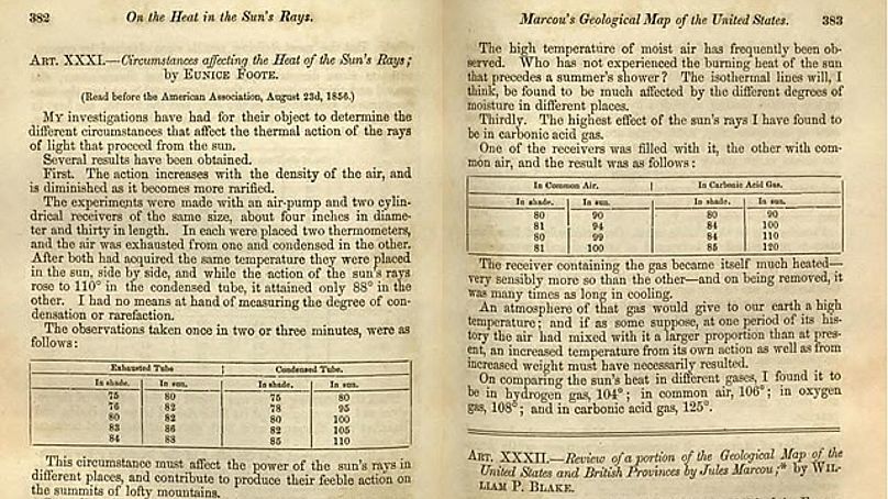
Foote's scientific paper, 'On the heat in the sun's rays'
Library of Congress

Foote’s scientific paper ‘On the heat in the sun’s rays’ was published in the American Journal of Science and Arts in November 1856.

The experiment that she conducted involved two glass cylinders, two thermometers and an air pump. She pumped carbon dioxide into one of the cylinders and air into the other, and then placed them out in the sun.

“The receiver containing the gas became itself much heated - very sensibly more so than the other - and on being removed, it was many times as long in cooling,” she says in her paper.

The higher temperature in the carbon dioxide cylinder showed Foote that carbon dioxide traps the most heat. She performed the experiment on a range of different gases including hydrogen and oxygen.

“On comparing the sun’s heat in different gases, I found it to be in hydrogen gas, 108°; in common air, 106°; in oxygen gas, 108°; and in carbonic acid gas, 125°.”

This finding led Foote to conclude that, “An atmosphere of that gas would give to our earth a high temperature; and if as some suppose, at one period of its history the air had mixed with it a larger proportion than at present, an increased temperature from its own action as well as from increased weight must have necessarily resulted.”

This was the first scientific acknowledgement that CO2 had the power to change the temperature of the Earth.

Why did John Tyndall get the credit?


John Tyndall was an Irish physicist, who was already well known within the scientific community for his work on magnetism and polarity when Foote published her findings.

In fact, Tyndall had published a paper on colour blindness in the same edition of The American Journal of Science and Arts as Foote had published her carbon dioxide experiment.

Then in 1861, John Tyndall demonstrated the absorptive nature of gases, including oxygen, water vapour and carbon dioxide.
Using a ratio spectrophotometer of his own design, he measured the infrared absorption of these gases in what would later become known as the ‘greenhouse effect’.

There is some debate as to whether Tyndall stole Foote’s research, though perhaps it is fairer to say that reading it influenced his future discoveries - though he did not reference her in his findings.

Tyndall was commemorated as one of the founding fathers of climate change science, while Foote was forgotten until the early 21st century.

Either way, the result is the same - Tyndall was commemorated as one of the founding fathers of climate change science, while Foote was forgotten until the early 21st century.

Tyndall remained a prominent scientist until his wife accidentally killed him in 1893 by giving him a fatal dose of chloral hydrate, which he took to treat his insomnia.

What was early climate science like?

The 19th century was a key turning point in climate science and the use of fossil fuels.
In 1800 the world population reached one billion for the first time and the industrial revolution began to take hold - fuelled by the development of James Watt’s steam engine in the late 18th century.

By the 1880s, coal was being used to generate electricity for factories, while the first automobile, Karl Benz’s ‘Motorwagen’ heralded the age of mass private transport.

By 1927, carbon emissions from fossil fuels and industry hit one billion tonnes per year. Just for context, in 2019 fossil fuel use hit 36.7 billion tonnes.

These massive societal changes were not fully understood at first, and Swedish chemist Svante Arrhenius believed in 1896 that the greenhouse effect and subsequent temperature rise from burning coal - which he correctly predicted would be a few degrees - might actually be beneficial for humanity.

In fact, the greenhouse effect and its cataclysmic consequences wouldn’t begin to be taken seriously until the mid 20th century, after US scientist Wallace Broecker coined the term 'global warming'.

Other scientific women who have been forgotten

Foote’s contribution to the history of climate science was finally rediscovered in 2010 by Ray Sorenson, a retired geologist.
He published his discovery and in 2019 the University of California in Santa Barbara put on an exhibition about Foote’s work.

Foote’s contribution to the history of climate science was finally rediscovered in 2010 by Ray Sorenson, a retired geologist.

Unfortunately, Foote isn’t the only female scientist to be written out of history or have their discoveries credited to a man.
Lise Meitner, a key member of the scientific team that discovered nuclear fission was overlooked for a Nobel Prize, which was given to her co-scientist Otto Hahn.

Thankfully though, women are beginning to get the recognition they deserve, as films like ‘Hidden Figures’, which tells the story of NASA mathematicians - Katherine G. Johnson, Dorothy Vaughan and Mary Jackson - show.

The three women of colour played key roles in the early years of NASA, but were historically overlooked until the film’s release in 2016.
 

"Climate change is a threat to human well-being and planetary health. Any further delay in concerted anticipatory global action on adaptation and mitigation will miss a brief and rapidly closing window of opportunity to secure a liveable and sustainable future for all." 

 
Links :

Monday, February 28, 2022

What makes the Black Sea so strategically important?

 
From DefenseNews by Megan Eckstein and Tayfun Ozberk

A Russian amphibious assault is underway in Ukraine, pushing thousands of Russian naval infantry from the Sea of Azov onto land west of port town Mariupol, according to a U.S.defense official.

It’s a scenario for which Russia has been laying the groundwork for years.
Ukraine has been training to defend against such an event since its naval fleet was decimated in 2014 after Russia took Crimea, the peninsula that separates the Sea of Azov from the larger Black Sea.

But an attack from the sea was something Ukraine was particularly vulnerable to — even if Russian forces have so far relied primarily on sending land forces across borders to attack Ukrainian cities.
 
Wading in

There’s only one way in and out of the Black Sea.
Russia regularly sends its ships and submarines in and out of the sea, surging forces there or sending its Black Sea Fleet into the Mediterranean Sea for local operations.
Ukraine, unlike Russia, has no other fleets elsewhere, so there’s no backup coming from outside the Black Sea.

Which leads to the question: Who else may come and go from the Black Sea?
 
Black Sea & Azov Sea with the GeoGarage platform (NGA nautical raster chart)
 
Due to Montreux Convention rules regarding the Bosporus and Dardanelles that connect the Black Sea to the Mediterranean Sea, countries that sit on the Black Sea have unlimited access.
Nonresident countries may only send ships in for short stints and are limited by ship size.
So although NATO is not intervening militarily on Ukraine’s behalf, the Black Sea was always going to be a vulnerable spot for Ukraine.

In other words, if there were ever a body of water well suited for bullying your neighbor, it would be the Black Sea.

A Russian Navy patrol vessel sails through the Bosporus on the way to the Black Sea past the Turkish city of Istanbul on Feb. 16, 2022.
(Ozan Kose/AFP via Getty Images)

Encircling the waterway are Turkey, Bulgaria, Romania, Ukraine, Georgia and Russia — three NATO members, two who want to join the alliance and then the nation currently invading Ukraine.

That political dynamic was always bound to create tension.
But since 2014, the Black Sea has become increasingly strategic and contested.
Crimea, located in the northern part of the sea, formerly housed the main hub of Ukraine’s naval force.
 
The Russian submarine Rostov-on-Don passes through the Bosphorus in Istanbul on its way to the Black Sea © Yoruk Isik/Reuters

Ukraine’s depleted naval force

Russia’s annexation of Crimea caused several challenges: first and foremost, about three-quarters of Ukraine’s naval fleet was based there at the Sevastopol Naval Base, and Russia took the ships, their repair yards, helicopters and any sailors willing to fight for Moscow.

Second, it gave Russia control of both sides of the Kerch Strait, which leads from the Black Sea to the Sea of Azov.
Ukraine still has legal claims to the Sea of Azov and controls much of the northwestern shores of the sea; but Russia controls land on the east and west sides of the strait, making it easier for the Kremlin to harass, block or take as hostage Ukrainian ships in the area.

And third, it significantly complicated claims to territorial waters within the Black Sea, with the Russian-controlled Crimean Peninsula jutting out into waters that would otherwise be clearly Ukrainian territorial waters under other circumstances.
 
A selection of naval assets shows Russia's Navy has a significant advantage over Ukraine's Navy.
(Source: International Institute for Strategic Studies)

Last summer, when U.S. Navy destroyer Ross was in the Black Sea for Ukraine-hosted naval exercise Sea Breeze 21, the ship hewed to Ukrainian and international waters only.
Defense News embarked on the ship for three days to observe the drills.
Despite the ship’s careful course, Russian naval forces near the Crimean Peninsula radioed to the ship — an unusual move in and of itself — to tell Ross to turn around.
It was approaching Russian waters, they claimed, and a Russian naval exercise was taking place.

Ross continued its operations, though with three to four Russian ships tailing it at any given time and Russian jets flying overhead.

Ukraine has done its best to rebuild its naval power since 2014, though it was left with one frigate as its only “large” warship.
It’s taken a “mosquito fleet” approach, trying to build up a number of small vessels that can protect the waters close in to the shore.
Eventually, the Navy planned to grow in size and skill set, buying larger ships that could patrol the more open waters of the Black Sea.

While the mosquito fleet patrols close-in waters, alongside the Sea Guard that falls under the State Border Guard Service (akin to the U.S. Coast Guard under the Department of Homeland Security), Russia freely deploys amphibious warships, missile frigates and more throughout the Black Sea.

Ukraine is at both a significant disadvantage and a significant threat right now as it relates to the Black Sea.
It lacks the firepower to engage the Russian fleet in any meaningful way.
The U.S., Navy and its European partners tried to help Ukraine learn to create maritime domain awareness by netting together sensors; the exercises were still focused on creating a common operating picture shared across at-sea and ashore personnel, not using that picture to pick out and prosecute targets.

Although Russian President Vladimir Putin hasn’t made his final intentions known, Ukraine’s coastal areas seem to have a target on their back.
He has already pushed forces from Crimea into the Ukrainian town Kherson.
From there, it’s not far across the coast to a naval base in Ochakiv and then onto port city and naval base Odesa.
Putin has also pushed forces from the Sea of Azov toward Mariupol — and from there, it would be just a short push northward to connect to Russian forces and Russian-backed fighters in Donetsk and Luhansk.
 

* Have access to armored fighting vehicles, anti-tank/anti-infrastructure platforms, artillery, and air defense systems.
(Source: International Institute for Strategic Studies)

Pursuing all these lines of effort would connect Russian-held areas in such a way that Putin’s forces could easily resupply themselves from the sea, whereas Ukraine would be cut off from maritime commerce and military opportunities.
It would also give him nearly half the Black Sea coastline and allow him to claim significantly more area as territorial waters.
 
Russia and Ukraine conflict throttled exports from one of the world’s largest grain suppliers after Ukraine's ports in the Black Sea halted operations.
Shipping in the AzovSea—an extension of the BlackSea has drastically reduced.
Ships are banned from passing through the narrow Kerch Strait into the shallow sea, and ship-tracking data showed dozens of ships, including the bulk carriers that transport grains, had anchored in the strait. (Feb 26)
 
The rules of the sea

Part of Putin’s advantage in the Black Sea is that his ships can come and go as they please, when few other navies have the right or ability to do so.

Ukraine’s ambassador to Turkey asked that the NATO member close the pair of straits to Russian ships to prevent Moscow from bolstering its Black Sea Fleet.
Under the Montreux Convention, Turkey manages the movement of commercial and military ships in and out of the Bosporus and Dardanelles.

Turkey said it cannot stop Russian ships accessing the Black Sea due to a clause in the rules that allows vessels to return to their home base, according to Reuters.
The country has carefully implemented the Montreux Convention of 1936, which is a critical component of Black Sea security and stability, for more than seven decades.
While the convention governs the transit regime across the straits, the most important aspect is defining the principals of military ships transiting the straits and deploying to the Black Sea.

The Ukrainian ship Hryhoriy Kuropyatnykov sails away from Odesa, Ukraine, in the Black Sea on the first day of the Sea Breeze 21 exercise's at-sea phase.
The ship operated in a task group with warships from the U.S., U.K., Romania and Bulgaria.
(Megan Eckstein/Staff)

The convention adds to Russia’s advantage there because it prohibits non-Black Sea states’ aircraft carriers and submarines from passing through.
Only submarines from bordering, or riparian, states are permitted to pass through the straits, either to rejoin their base in the Black Sea for the first time after construction or purchase, or to be repaired in dockyards outside the Black Sea.
However, though Russia has bent these rules in the past to deploy its Black Sea Fleet submarines to Mediterranean waters off Syria and elsewhere.

The Montreux Convention also limits non-riparian states’ naval power in the Black Sea in terms of deployment duration and armada tonnage.
Non-riparian states may have a maximum aggregate tonnage of 45,000 tons in the Black Sea.
In this regard, one non-riparian state may have a maximum aggregate tonnage of warships in the Black Sea of 30,000 tons.
Furthermore, warships from non-riparian countries are not permitted to stay in the Black Sea for more than 21 days.

While the convention generally promotes freedom of navigation through the straits, Turkey retains the right to close the straits to warships from belligerent countries in the event of war or the threat of war.
In wartime, Turkey is required by Article 19 of the treaty to close the straits to belligerent warships: “In time of war [v]essels of war belonging to belligerent Powers shall not, however, pass through the Straits except in cases arising out of the application of Article 25.”

Turkey arguably has the authority to close the straits under the principles outlined in the convention.
However, there are some political issues.
Turkey holds the convention in high regard and has carefully implemented regime rules because it regards the convention as an important component of the security and stability of the Black Sea.

As a result, if Turkey agreed to Ukraine’s request, Russia could make requests of its own, or even accuse Turkey of breaching its neutrality and retaliate.

According to Reuters, Turkish Foreign Minister Mevlut Cavusoglu argues the country can’t stop Russian warships from coming back to their home base — meaning it could stop Russia from sending ships into the Mediterranean, which is a non-issue right now, but it couldn’t stop Russia from flowing more ships to the Black Sea in the name of sending them back to their home port.

Russia could also further bolster its Black Sea Fleet by sending its Caspian Flotilla through the Don-Volga waterway.
That force consists of two frigates and seven corvettes, the majority of which are armed with Kalibr missiles.

Because closing the straits is likely to have little impact on Russian capabilities in the Black Sea but would put Turkey at risk of retaliation, or at least lose the appearance of neutrality, it’s unlikely Turkey will take action under the rules of the Montreux Convention.
 
Links :

Sunday, February 27, 2022

A massive hydrogen-powered boat can make its own fuel from seawater

Energy Observer is a former race boat with the aim of testing the efficiency of different sources of renewable energy.
48,000 nautical miles and 60 stopovers later, next step with a new program for 2025: Energy Observer 2, a new concept of zero-emission cargo ship that will integrate disruptive technologies, reliable but never before assembled on a ship of such power. 
 
Links :