Emerging explorer Jessica Cramp and her team dive to the depths of the Galapagos to explore never before seen creatures.
Saturday, October 12, 2024
Friday, October 11, 2024
Hurricane Milton shows how a storm’s category doesn’t tell the full story

Photograph: National Oceanic and Atmospheric Administration;
AP Newsroom
Milton’s reclassification to a Category 3 storm suggests it is weakening, but the scale accounts only for wind speed and not hurricane size, storm surge heights, or rainfall—which are all catastrophically large.
As Hurricane Milton roared toward the west coast of Florida on Tuesday and Wednesday, its 180-mile-per-hour winds weakened to 145 miles per hour, rose again, and then fell.
What had been one of the quickest ever storms to reach Category 5 strength—which is when wind speeds top 156 mph—flicked back and forth between Categories 4 and 5.
It ultimately arrived at the coast on Wednesday as a Category 3 storm, with winds of 125 mph.
But while Milton’s wind speed was reduced, the inundation of water forecast for Florida remained just as massive as before.
Tampa, a city of 3 million that hasn’t taken such a direct hit in a century, faces a storm surge of 10 to 15 feet, along with nearby St.
Petersburg and Sarasota, according to the National Hurricane Center.
This comes less than two weeks after Hurricane Helene pushed an 8-foot surge into the area.
Central and northern Florida could also see 12 inches of rainfall, with up to 18 inches in isolated areas.
That Milton could decrease in category but still threaten such a high storm surge and volume of rainfall shows a major shortcoming of the Saffir–Simpson scale, by which we assign hurricanes categories 1 through 5: It’s based solely on wind speed, even though in an era of climate change, hurricanes have been unleashing more and more water on cities.
That has left hurricane forecasters trying to move beyond these categories and convey the risk of storm surge and flooding, so people will still evacuate even if wind speeds slacken.
Timelapse flying by Hurricane Milton about 2 hours ago.
— Matthew Dominick (@dominickmatthew) October 8, 2024
1/6400 sec exposure, 14mm, ISO 500, 0.5 sec interval, 30fps pic.twitter.com/p5wBlC95mx
“The public needs to not focus totally on the number in the category,” says Erik Salna, a meteorologist at the International Hurricane Research Center at Florida International University.
“The fact that it has already been a major hurricane, it will still have that momentum, power, and force on the water.
And the biggest killer is water, not the wind.”
The Saffir–Simpson scale is “a great way to show really the intensity of an open-water storm system,” says Brian Hurley of the US National Weather Service.
“But it should not be the end-all be-all for diagnosing the threats.”
Modern hurricane forecasting was born in 1943, when a US Army Air Corps pilot flew a two-person propeller plane into the eye of a hurricane on a barroom dare, and then repeated the stunt with a meteorologist on board.
This gave birth to subsequent innovations like aerial surveys, but while these gave weather watchers a lot more data—on how low the barometric pressure in the storm had fallen, how fast a hurricane was spinning, and how fast it was moving toward shore—they still struggled to express the level of danger to the public.
For instance, in 1969, many residents of Mississippi failed to evacuate before Hurricane Camille slammed into the coast with estimated winds of up to 200 miles per hour, despite detailed weather reports, and 256 people died.
National Hurricane Center director Robert Simpson subsequently decided to adopt a categorization of hurricane wind speed developed by his friend, Miami civil engineer Herbert Saffir, leading to the Saffir–Simpson scale.
Simple and evocative, it gave even the most uninformed people the sense that categories 3, 4, and 5 are major hurricanes, with major destructive potential.
“Its great advantage is everybody knows it, and everybody more or less knows what to be afraid of,” says Richard Olson, director of the International Hurricane Research Center.
This simplicity comes at a price, however.
Since it’s based on the maximum wind speed achieved, the scale doesn’t say anything about the size of a storm.
Hurricane Katrina, for instance, hit New Orleans in 2005 as a Category 3, weaker than Camille.
But it was much larger, with hurricane-force winds extending 105 miles from its center rather than 60 miles for Camille, and it did a lot more damage.
The scale also doesn’t address flooding—neither the storm surge of ocean water pushed onshore by a hurricane, nor the heavy rainfall it dumps as it passes over land.
Originally each category included an expected range of storm surge, but the National Hurricane Center removed this in 2010.
That’s because factors besides just wind speed influence the surge.
A hurricane that moves forward quickly or has a large radius will push more water onshore than a smaller, slower storm, especially if a shallow continental shelf forces that water mass upward.
The storm surge will be higher when squeezed into a bay like the one around Tampa or when a hurricane barrels head-on into the coast rather than at an angle.
Hurricanes like Katrina showed the potential for confusion: The gigantic storm surge of up to 28 feet far exceeded the 12 feet predicted based on its Category 3 wind speed, corresponding instead to what would be expected from a Category 5.
In response, StormGeo, an advisory firm that helps its clients decide when to shut down infrastructure like oil refineries and retail stores, developed the Hurricane Severity Index.
“We realized the Saffir–Simpson scale didn't accurately reflect the storm-surge capabilities of a storm,” says StormGeo meteorologist Bob Weinzapfel.
The index measures wind speed on a 25-point scale and a storm’s size—that is, how far these high winds extend—on another, to give a total rating out of 50, and compares that to historic hurricanes.
By that index, Milton has 11 size points and 12 intensity points.
For its part, the National Hurricane Center started issuing storm surge watches and warnings in addition to categorizing hurricanes based on windspeed.
Its bulletins now also include risks of rainfall, tornadoes, and high surf.
“We’ve worked to separate the impacts to best represent areas on the immediate coast and for those a few miles to hundreds of miles away,” says Maria Torres, a meteorologist at the center.
But the Saffir–Simpson scale remains the key measurement, unless you have the time to click deeper into your regional weather service website.
And as climate change supercharges hurricanes, which are fueled by warm water and air, the sufficiency of the system's five categories is increasingly coming into question.
After Milton’s wind speed skyrocketed from a 60 mph tropical storm to a 180 mph Category 5 hurricane in only 36 hours, experts are again discussing whether a Category 6 needs to be added.
Milton’s enormous storm surge has also highlighted the growing danger from water.
More intense hurricanes are pushing higher storm surges due to sea-level rise.
These “hurricanes on steroids,” as Olson calls them, are also dumping larger amounts of rain inland, just as Hurricane Helene did in North Carolina late last month.
Between 2013 and 2022, flooding due to heavy rainfall accounted for a whopping 57 percent of hurricane deaths, with storm surges responsible for another 11 percent, according to the National Hurricane Center.
Wind caused only 12 percent.
The International Hurricane Research Center is known for its “wall of wind,” a hangar of 12 giant yellow fans that can generate 157 mph winds to test the resilience of building materials.
Now it has a $13 million federal grant to design and prototype a new facility with 200 mph fans and a 500-meter wave pool, to test the effects of windier, wetter hurricanes.
“That’s real-world. You don’t get just wind, just water, just wave. You get all three,” Olson says.
Some meteorologists say we need a different scale entirely.
Carl Schreck, a research scientist at North Carolina University, has proposed a Category 1–5 scale based on sea-level pressure to better incorporate water.
A low pressure boosts both wind speed and storm size, and larger storms tend to have bigger surges and more rain.
A Category 5 would be a hurricane with a pressure lower than 925 millibars.
By this measurement, Milton would have remained a Category 5 until mid-Wednesday rather than vacillating between 4 and 5.
“Pressure is easier to measure, easier to forecast, and matters more for damage, but NHC, through inertia, they’re tied to the current system, and they think changing it would confuse people, unless there’s a silver bullet,” Schreck says.
“And there is no silver bullet.”
No single number can capture all hurricane impacts.
That was demonstrated by Helene, which made landfall in Florida as a Category 4 but unleashed “biblical” rainfall hundreds of miles inland in Georgia, South Carolina, and North Carolina.
The storm killed more than 200 people, half of them in western North Carolina, where mountain valleys channeled the rainfall into devastating floods.
The impact was compounded by a tropical storm that showered the Carolinas with historic rainfall two days before Helene.
Before Helene hit, forecasts compared its rainfall to hurricanes Frances and Ivan, which brought up to 18 inches of rain to some parts of North Carolina in 2004, triggering 400 landslides and killing 11.
They also cited a record-setting flood in 1916, warning that the “impacts will be life-threatening.”
The storm two days before Helene was described as a “once-in-a-thousand-year event.” But the fact that so many people died nonetheless shows a “communication disconnect” between our storm warning system and the public, says Schreck, who lives in Asheville and was without power and water for days.
He’s also helped develop an “enhanced rainfall” scale, where a Category 5 event pours five times as much rain as an area would get once every two years on average, a Category 4 dumps four times as much, and so on.
The predicted rainfall would have made Helene a Category 3 extreme rainfall event in the mountains of North Carolina rather than just a Category 4 hurricane on the coast of Florida.
“Nobody knows what 500 or 1,000 years means.
It’s basically inconceivable,” Schreck says of probability-based systems.
“So it’s saying, take the biggest event you can remember and multiply it by three.”
Inside Hurricane Milton, @saildrone reported wave height of 28.12 feet and wind gusts as strong as 75.95 mph while 40 nautical miles from the center of the storm. This research represents a collaborative endeavor to better understand the role of the ocean in hurricanes. pic.twitter.com/gmaUopPEWj
— NOAA Atlantic Oceanographic and Meteorological Lab (@NOAA_AOML) October 9, 2024
Not everyone will evacuate even for a major storm, however, especially in a hurricane-weary state like Florida.
More than a million people were under an evacuation order there for Milton, with Governor Ron DeSantis urging residents to “run from the water” and the mayor of Tampa warning those who don’t are “going to die.” But one mother named Amanda Moss went viral with TikTok videos saying she didn’t have the money for flights and hotels to evacuate her husband, mother-in-law, six children, and four French bulldogs from Fort Meyers, which faces up to 12 feet of storm surge.
In the comments, some other users said they were also staying put, arguing they couldn’t get off work or were worried about gas shortages.
It’s not just “a pride or an ego thing,” as Moss put it.
Thirteen percent of Americans wouldn’t be able to cover an emergency expense of $400, and 38 percent would have to pay with a credit card, sell a possession, or take out a loan to cover it, according to the Federal Reserve.
“There is not like one sentence that you can get on air and say that is going to get everybody to evacuate,” says Samantha Montano, an assistant professor of emergency management at Massachusetts Maritime Academy, who favors retiring the Saffir–Simpson scale altogether.
Rather than wind speed or sea-level pressure categories, hurricane forecasts should focus on local impacts in certain areas, she says.
For Tampa right now, that’s 15 feet of water in the streets, winds that could tear off your roof, and rainfall that can overwhelm drainage systems and wreck your car.
“Any scale that we’re using to communicate with the public that isn’t accounting for what impacts are isn’t going to capture what the public needs to capture in order to be able to understand the risk,” Montano says.
Links :
- Wired : Hurricane Hunter Explains How They Track and Predict Hurricanes
- NASA : Extremely Powerful Hurricane Milton forms in the Gulf of Mexico / Fuel for Hurricane Milton / Three Storms Churn in an Active Atlantic
- Yahoo : Hurricane Milton live tracker
- Climate : Hurricane Milton rapidly intensifies into Category 5 hurricane, becoming the Gulf's strongest late-season storm on record
- NOAA NHC : Tracking
- GeoGarage blog : The 5 hurricane categories, explained
Thursday, October 10, 2024
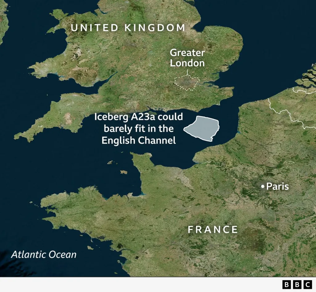
World's biggest iceberg spins in ocean trap
Derren Fox/BAS
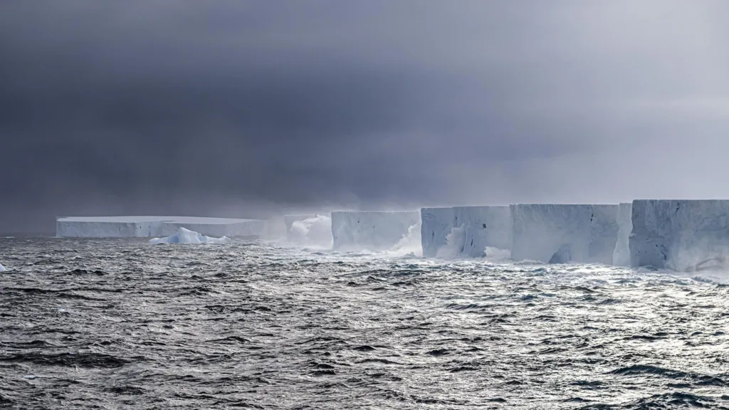
A23a is vast. Its flat, table-like top stretches to the horizon
A23a is vast. Its flat, table-like top stretches to the horizon
Something remarkable has happened to A23a, the world's biggest iceberg.
For months now it has been spinning on the spot just north of Antarctica when really it should be racing along with Earth's most powerful ocean current.
Scientists say the frozen block, which is more than twice the size of Greater London, has been captured on top of a huge rotating cylinder of water.
Satellite imagery recorded Iceberg A23a spinning around the Weddell Sea off Antarctica during February. (Video: NOAA)
"Usually you think of icebergs as being transient things; they fragment and melt away. But not this one," observed polar expert Prof Mark Brandon.
"A23a is the iceberg that just refuses to die," the Open University researcher told BBC News.
View from space: A23a should have long departed for much warmer waters
The berg's longevity is well documented. It broke free from the Antarctic coastline way back in 1986, but then almost immediately got stuck in the bottom-muds of the Weddell Sea.
For three decades it was a static "ice island". It didn't budge.
It wasn't until 2020 that it re-floated and started to drift again, slowly at first, before then charging north towards warmer air and waters.
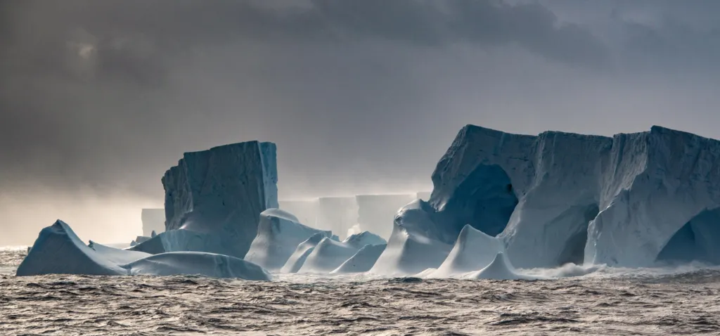 Chris Walton/BAS
The berg may be crumbling along its edges, but its greater bulk remains intact
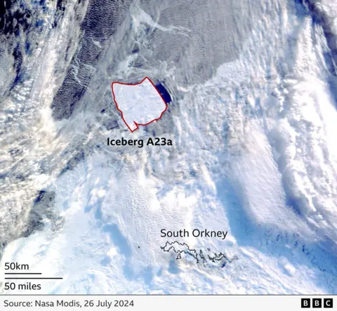
In early April this year, A23a stepped into the Antarctic Circumpolar Current (ACC) - a juggernaut that moves a hundred times as much water around the globe as all Earth's rivers combined.
This was meant to put boosters on the near-trillion-tonne berg, rifling it up into the South Atlantic and certain oblivion.
Instead, A23a went precisely nowhere.
It remains in place just north of South Orkney Islands, turning in an anti-clockwise direction by about 15 degrees a day. And as long as it does this, its decay and eventual demise will be delayed.
A23a has not grounded again; there is at least a thousand metres of water between its underside and the seafloor.
It's been stopped in its tracks by a type of vortex first described in the 1920s by a brilliant physicist, Sir G.I. (Geoffrey Ingram) Taylor.
The Cambridge academic was a pioneer in the field of fluid dynamics, and was even brought into the Manhattan Project to model the likely stability of the world's first atomic bomb test.
Prof Taylor showed how a current that meets an obstruction on the seafloor can - under the right circumstances - separate into two distinct flows, generating a full-depth mass of rotating water between them.
In this instance, the obstruction is a 100km-wide bump on the ocean bottom known as Pirie Bank. The vortex sits on top of the bank, and for now A23a is its prisoner.
The iceberg covers an area of 3,600 sq km, or 1,400 sq miles
"The ocean is full of surprises, and this dynamical feature is one of the cutest you'll ever see," said Prof Mike Meredith from the British Antarctic Survey.
"Taylor Columns can also form in the air; you see them in the movement of clouds above mountains. They can be just a few centimetres across in an experimental laboratory tank or absolutely enormous as in this case where the column has a giant iceberg slap-bang in the middle of it."
How long might A23a continue to perform its spinning-top routine?
Who knows, but when Prof Meredith placed a scientific buoy in a Taylor Column above another bump to the east of Pirie Bank, the floating instrument was still rotating in place four years later.
A23a is a perfect illustration once again of the importance of understanding the shape of the seafloor.
Submarine mountains, canyons and slopes have a profound influence on the direction and mixing of waters, and on the distribution of the nutrients that drive biological activity in the ocean.
And this influence extends also to the climate system: it's the mass movement of water that helps disperse heat energy around the globe.
A23a's behaviour can be explained because the ocean bottom just north of South Orkney is reasonably well surveyed.
That's not the case for much of the rest of the world.
Currently, only a quarter of Earth's seafloor has been mapped to the best modern standard.
SEABED2030/Nippon Foundation
Areas of the ocean floor in black have yet to be properly surveyed
Links :
- BBC : Scientists probe the secrets of mega icebergs / A23a: Tracking the world's biggest iceberg / Oceans' extreme depths measured in precise detail / A23a: World's biggest iceberg on the move after 30 years
- The week : Iceberg A23a is taking a spin
- CNN : The world’s largest iceberg is spinning in an ocean vortex with no end in sight
- NYTimes : After Breaking Free, World’s Largest Iceberg Is Stuck Spinning in Circles
- WP : Earth’s biggest iceberg is caught in a spin cycle
- Smithsonian : The World’s Largest Iceberg Is Stuck in a Spinning Ocean Vortex
- Newsweek : World's Largest Iceberg May Be Trapped in Ocean Vortex for Years
- Phys : New animation shows track of giant A23a iceberg
- NASA : Antarctic Iceberg Sails Away
- GeoGarage blog : A23a: World's biggest iceberg on the move after 30 years / We went to the biggest iceberg in the world on RRS Sir ...
Wednesday, October 9, 2024
Petros Arapakis: the Greek legend who conquered the seas
 Petros Arapakis and his globetrotting adventures made headlines more than one hundred years ago.
Credit: Greek Reporter
From GreekReporter by Stacey Harris-Papaioannou
Petros Arapakis wagered that Greeks were the best sailors in the world.
That bet cost him his life but made him both a local and international legend.
Born and raised in a castle in the Mani region in the 19th century, today the Arapakis estate is a four star hotel in Charia, just six miles from Aeropolis, the prefecture’s capital.
And perhaps it was the very landscape of Arapakis’ home that encouraged his wanderlust for the open sea and adventure.
Although raised on mainland Greece, he may as well have been on an island.
Mani, located on the Peloponnesian Peninsula, was one of the most inaccessible, wildest and difficult-to-rule parts of Greece, which, until the 1970s, could only be accessed by boat.
The 50-mile-long peninsula is washed by the waters of the Messinian and the Laconian Gulfs, which are crystal clear and free of pollution.
It begins north of the Taygetos mountain range, the western spine of the Peloponnese which separates East Mani from West Mani, and ends at Cape Tainaron, the southernmost tip.
Areopolis, its capital, literally translates in Greek to mean “city of war.”
The people of Mani, known as Maniotes, have the reputation of being the fiercest people of Greece.
The landscape reflects the character of its people, rugged and barren, bathed in merciless sunlight and dominated by stone.
However, it is also framed by beautiful cypress and olive trees and all sorts of wildflowers.
Over the centuries, it has shaped its own history and government, which is unique in Greece.
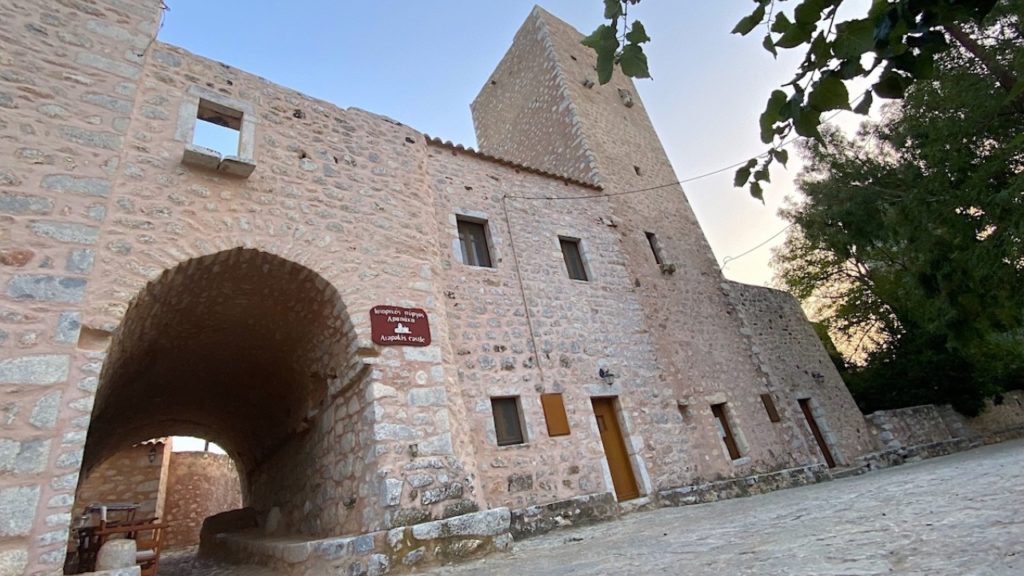
The original home of Petros Arapakis, a legendary Greek seafarer.
Credit: Greek Reporter
Once a base for pirates, impregnable to all types of raids, this land has been inhabited from prehistoric times until today, populated by proud and independent people.
The landscape is filled with old houses, numerous caves, isolated fortified towers, tower houses, huts, fountains, bridges and a multitude of narrow roads stretching from the most inaccessible mountains to its beaches, connecting the different parts of the region.
These structures point out the unique history, social organization and lifestyle that developed in Mani.
Katie Arapakis, a civil engineer who is also the wife of Nikolas Arapakis, a third generation descendant of the legendary seafarer, spoke to Greek Reporter recently about her family and the business they have developed out of their family history.
Arapakis a descendant of Greek War of Independence Fighter
Petros Arapakis was born in Charia, Mani in 1879.
He was the grandson of an independence fighter from 1821, Ilias Arapakis.
He was the grandson of an independence fighter from 1821, Ilias Arapakis.
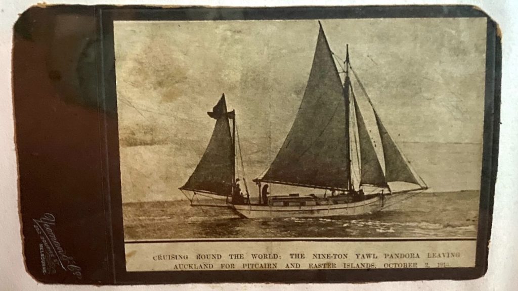
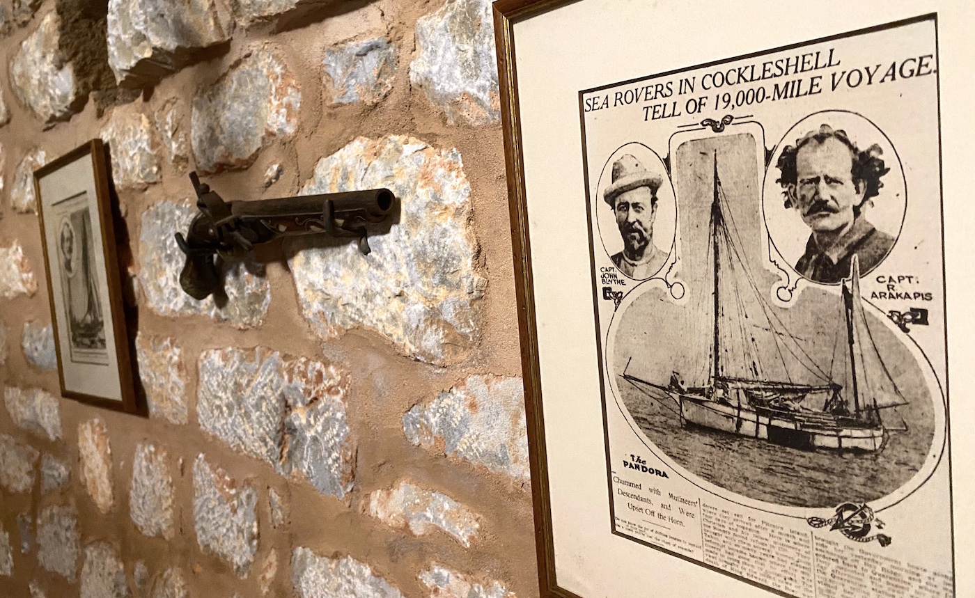
The Pandora, the sloop in which Petros Arapakis and George Blythe attempted to navigate around the world.
Credit: Greek Reporter
From a very young age he showed his love for the sea.
At 16, in a tiny 16-foot sailboat, he traveled 1,500 miles around the shores of the Mediterranean to meet his friends, defying danger and hardship.
In 1903, at 24, he was the first to enter the unexplored cave of Vlychada, one of the caves of Diros.
According to Katie Arapakis, the legends were that Petros Arapakis carved his name on the cave wall 4,000 feet inside its interior.
Ioannis Petrochilos, a Greek speleologist, confirmed this when he explored Vlychada in 1949.
Sailing Chosen Over Medical Career
Petros Alapakis attended Kalamata High School and then enrolled in the University of Athens Medical School, following in the footsteps of both his father and independence fighter grandfather, who were both doctors.
His love for the sea prevailed, however, and after a year, he abandoned medical school.
Arapakis went to England and enrolled in the Merchant Mariners School in London.
Upon his graduation he created an impressive nautical chart.
He then traveled to New York where he worked in the shop of a fellow Maniotes.
After saving some money, Arapakis journeyed to Australia in 1908.
In Sydney he met a wealthy young woman named Cecilia Adams.
She hired Arapakis to captain her yacht and it wasn’t long before the two fell in love.
While in Sydney, with two friends, a German man named Friedrich and an Englishman, George Blythe, both men of the sea, Arapakis got into a heated discussion about which nationality had the best sailors.
Each of the men claimed their own countrymen to be superior.
To prove his point, Arapakis said he would travel around the world by boat to demonstrate that the Greeks are the best sailors in the world.
Wager: Greeks Are the World’s Best Sailors
Adams offered her yacht, the Pandora, 130-foot sloop of nine tons, to Arapakis for the challenge, as well as 60 pounds a week to anyone who would accompany the sailor on his daring venture.
Blythe agreed to join Arapakis as his first mate.
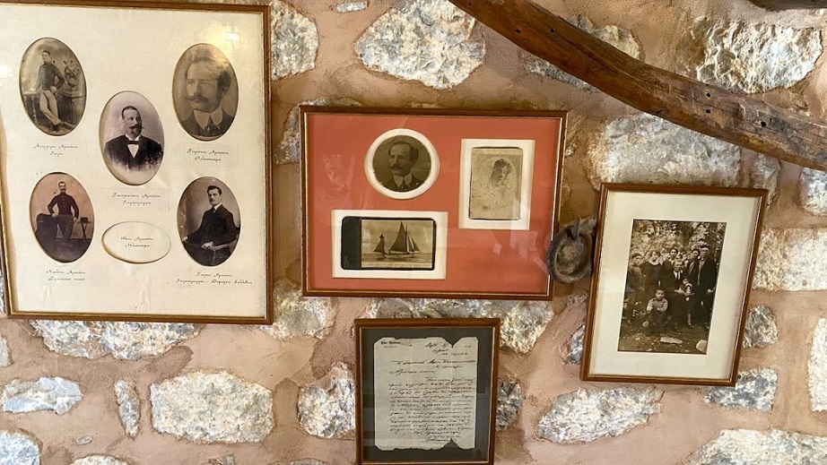 You View photos of the Arapakis family legend inside the tower at the Arapakis Castle.
Credit: Greek Reporter
Adams and Arapakis were engaged before he departed on the journey.
According to Katie, Blythe used the journey of American Joshua Slocum, who in 1895 had crossed the Atlantic alone from Boston to Gibraltar, as a guide for the journey with Arapakis on the Pandora.
They set sail from Western Australia on May 3, 1910.
On May 29, after a dangerous 2,000-mile sail, they arrived in Melbourne, where they stayed for a few weeks.
They arrived in Sydney on August 16.
The following day they departed for New Zealand.
On October 2, 1910, the Pandora left New Zealand to venture across the Pacific aiming for Cape Horn, on the southern tip of South America.
The Horn is the point where the Atlantic and Pacific Oceans meet.
The waves in the area are some of the largest on Earth, and navigating through the area is exceedingly dangerous.
On January 22, 1911, after coming to the Horn, while they were only three miles off the coast, a huge wave overturned the Pandora — but another miraculously brought it upright again.
A Norwegian whaler in the area towed them into where Petros and Blythe were able to repair the Pandora’s damage.
They were then able to continue their journey north to America.
Eventually, the two daring seafarers managed to reach New York.
Arapakis sails to New York
According to Katie, Arapakis and Blythe arrived in New York to an incredible reception.
Petros moored the Pandora alongside an ocean liner while newspapers devoted many pages to the incredible achievement of the two sailors.
A photo that was published was captioned with “The largest and smallest ocean liners in the world.”
Arapakis was courted by many a businessman who wanted to cash in on the sailor’s success — but he refused.
And there were even those who incredibly wanted to do harm to the vessel so Arapakis could not continue the journey.
Petros slept aboard the Pandora to thwart any potential sabotage.
Before departing New York, an American sailor, T. F. Day, warned Arapakis and Blythe that their habit of tying the rudder and leaving the yacht to sail by itself was very dangerous.
Nonetheless, they departed New York with a course charted for London with plans to cross the Mediterranean, arrive in Greece and continue through the Suez Canal to finish their journey back in Australia.
They managed to cross the Atlantic and were spotted off the coast of Spain by an ocean liner — but the Pandora had suffered severe damage from the storms they encountered crossing the Atlantic.
The sailors were in tattered clothes, long hair, beards and were red-eyed from insomnia by the time they were found.
They had no water and no food.
They refused to disembark from the Pandora and only asked for water and food from the crew of the ocean liner.
Arapakis was adamant about this, stating, “I started on a mission.
I will either arrive or I will lose.”
According to Katie that was in March of 1911 and it was the last time the pair was ever seen alive.
Either a storm sank the Pandora or they collided with another ship or rocks along the shore because they had kept the rudder tied while they were at sea.
It is estimated that the courageous men had traveled a total of 122,000 nautical miles.
Arapakis and Blythe made world naval history, as the first to sail from Cape Horn from West to East.
“A Mariner’s Miscellany” states that they crossed Cape Horn in 1911 in the sloop Pandora.
“A Mariner’s Miscellany” states that they crossed Cape Horn in 1911 in the sloop Pandora.
 Petros Arapakis, the seafarer from Mani, who traveled The Horn.
Credit: Greek Reporter
In 1940, shortly before the WWII, Cecilia Adams, Arapakis’ fiancée, came to Greece.
She wanted to see the homeland of her beloved — even three decades after he had tragically given up his life on the water.
She stayed in Greece for 15 days.
Arapakis’ brother, Giagos-Ioannis Arapakis, a prominent doctor and Mayor of Kallithea from 1933 to 1941, showed Adams Athens and Mani.
Arapakis’ Descendants Preserve Legend and Castle
Today, Arapakis’ descendants are keeping his memory and his legend alive.
They created a hotel, open year round, called the Arapakis Castle on the family’s estate in 2010.
At the time Katie Arapakis told Greek Reporter that they were doing their best to maintain the structures on the property but it was at great cost.
They used a development law to finance preserved heritage buildings by converting the private property into a hotel.
The ownership of the entire property was distributed among eight family members, each holding title to particular buildings.
Katie states to Greek Reporter that her family owned the tower and the mill.
There were private homes as well, along with an olive press that belonged to other members of the family.
They were all in agreement to convert the property to facilitate its preservation.
Today, Katie’s family oversees the operation of Arapakis Castle.
Within the tower, there is a collection of historical photographs on display of the legendary Arapakis and his shipmate Blythe, as well as excerpts from the published articles of the New York Times about their travels.
Arapakis Castle seems to be a magnet for love stories and adventure.
The Greek television channel MEGA filmed the series “Gei Tis Elias,” Land of the Olives, on the hotel property.
Katie told Greek Reporter that rooms within the hotel complex have been used for the filming.
The romantic drama takes place in the heart of Mani, during olive picking, an activity that no one and nothing can stop.
It is a story of two young lovers and the secrets that emerge.
Just a three-hour road trip from Athens, Mani is a fascinating vacation destination, not only for the summer but also for weekends and holidays year-round.
Castle battlements, Byzantine churches, traditional settlements, towers and monuments, cobbled trails and the Diros caves — this is what awaits those who visit Mani.
The masterful use of the stone in each structure, with the characteristic cornerstones, carved stones, domes, turrets, murder-holes, cages, etc., lend a peculiar morphology to the region’s unique and fascinating architecture.
It is one the most traditional areas of the Peloponnese with 800 towers and tower houses, more than 1000 Byzantine and post-Byzantine churches, 8 castles, 98 out of 118 traditional settlements of the Peloponnese, and more than 100 caves, including the world-renowned Diros Caves.
The region is home to more than 1000 plant species, over 120 Greek endemic plants of which 32 are locally endemic and unique in the world.
The climate is perfect for the growth of olive trees, which produce superior oil.
The rich vegetation of herbs and aromatic plants help to produce high quality honey.
Arapakis Castle offers the opportunity to get acquainted with this legendary sailor and to explore the wonders of the Mani countryside — or even get caught on camera as a televised romance is being filmed on its grounds.
Tuesday, October 8, 2024
Europe’s exhausted oyster reefs ‘once covered area size of Northern Ireland’
From The Guardian by Steven Morris
Study uncovers vivid and poignant accounts of reefs as high as houses off countries including UK, France and Ireland
Only a handful of natural oyster reefs measuring at most a few square metres cling on precariously along European coasts after being wiped out by overfishing, dredging and pollution.
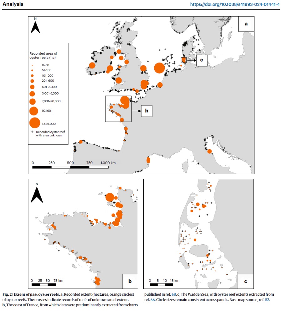
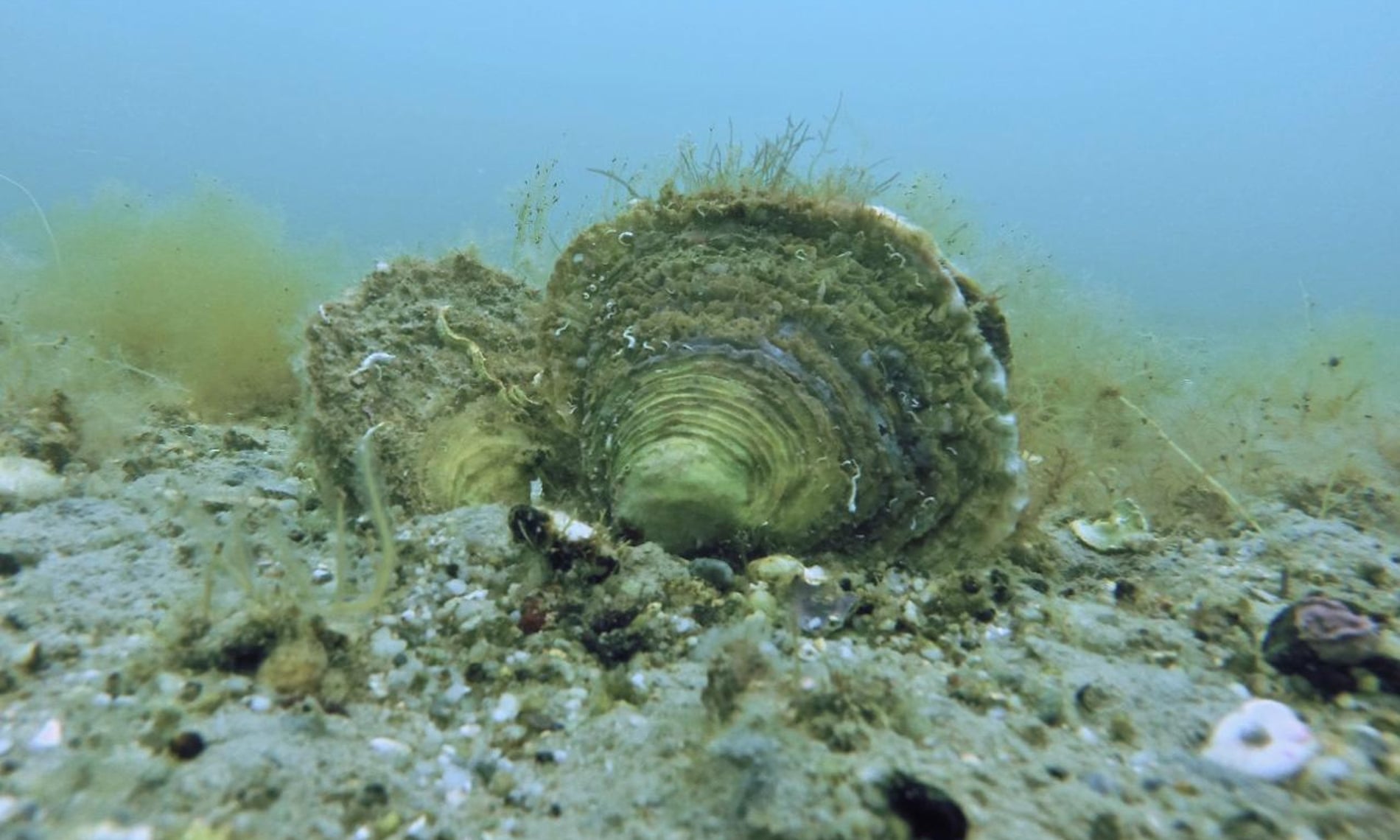 A study led by British scientists has discovered how extensive they once were, with reefs as high as a house covering at least 1.7m hectares (4.2m acres) from Norway to the Mediterranean, an area larger than Northern Ireland.
The study involved dozens of researchers poring over government records, nautical charts, fishery reports, customs documents, naturalists’ accounts, scientific journals and newspapers from the 18th, 19th and early 20th centuries to piece together the spread of the European flat oyster (Ostrea edulis).
They found vivid – and poignant – accounts of often sprawling reefs at 1,196 locations off countries including the UK, France, Ireland, Denmark, Spain, Germany and the Netherlands.
Only a handful of natural oyster reefs measuring at most a few square metres cling on precariously along European coasts after being wiped out by overfishing, dredging and pollution.
Oyster reefs once thrived along Europe’s coasts.
Photograph: Stephane Pouvreau
The study involved dozens of researchers poring over government records, nautical charts, fishery reports, customs documents, naturalists’ accounts, scientific journals and newspapers from the 18th, 19th and early 20th centuries to piece together the spread of the European flat oyster (Ostrea edulis).
They found vivid – and poignant – accounts of often sprawling reefs at 1,196 locations off countries including the UK, France, Ireland, Denmark, Spain, Germany and the Netherlands.
One report from a scientific article mentioned oyster reefs reaching 7 metres in height in the Black Sea.

A depiction of vessels dredging for oysters off the UK coast.
Photograph: Handout
Ruth Thurstan from the University of Exeter, the joint lead author of the report, said she was “blown away” by the extent of the reefs. “I knew that oysters used to be caught in huge quantities, so we suspected that these reefs could be large, but to find information that evidenced such coverage of reefs, amazed me.
“Few people in the UK today will have seen a flat oyster, which is our native species. Oysters still exist in these waters but they’re scattered, and the reefs they built are gone. We tend to think of our seafloor as a flat, muddy expanse, but in the past many locations were a three-dimensional landscape of complex living reefs.”
The reefs created rich ecosystems, providing a habitat for almost 200 fish and crustacean species including the common stingray, the short-snouted seahorse and the European sturgeon. They also played a vital role in stabilising shorelines, nutrient cycling and water filtration.
Thurstan said: “There are a handful of remnant reefs in a few parts of Europe, including the coast of Brittany and the west coasts of Ireland and Scotland. But these are at most a few square metres in extent, as opposed to square kilometres in the past. The significant ecological functions these reefs used to provide no longer exist, which is what we mean by functionally extinct.”

Reefs have largely disappeared but clumps of oysters can still be found. Photograph: Stephane Pouvreau/Ifremer
Some of the accounts the researchers found make for sad reading as people realised what was being lost.
One writer in 1852 reported: “In the Wash, about 50 years ago, were enormous oyster beds; one extending nearly the whole length of the Wash and continuing outside about 50 miles.”
A description of a “great” reef three miles off the Isle of Man read: “It took 20 boats seven years to dredge away these oysters. The oysters were thick on that bed … One boat has got 30,000 oysters in a week.”
An account from France describes oyster fishing in 1909: “From 10 April to 24 April, fishing took place. The number of oysters caught was 16 million.”
Oyster restoration projects are under way but the researchers say they need to be scaled up.
Philine zu Ermgassen, an honorary researcher at the University of Edinburgh, said the destruction of the slow-forming reefs had been rapid.
“These were huge areas that were thickly crusted with oysters and crawling with other marine life. There has been a fundamental restructuring and flattening of our sea floors.”
The report, The World Was Our Oyster: Records reveal the vast historical extent of European oyster reef ecosystems, is available online.
The report, The World Was Our Oyster: Records reveal the vast historical extent of European oyster reef ecosystems, is available online.
Links :
Monday, October 7, 2024
Britain to return Chagos Islands to Mauritius ending years of dispute
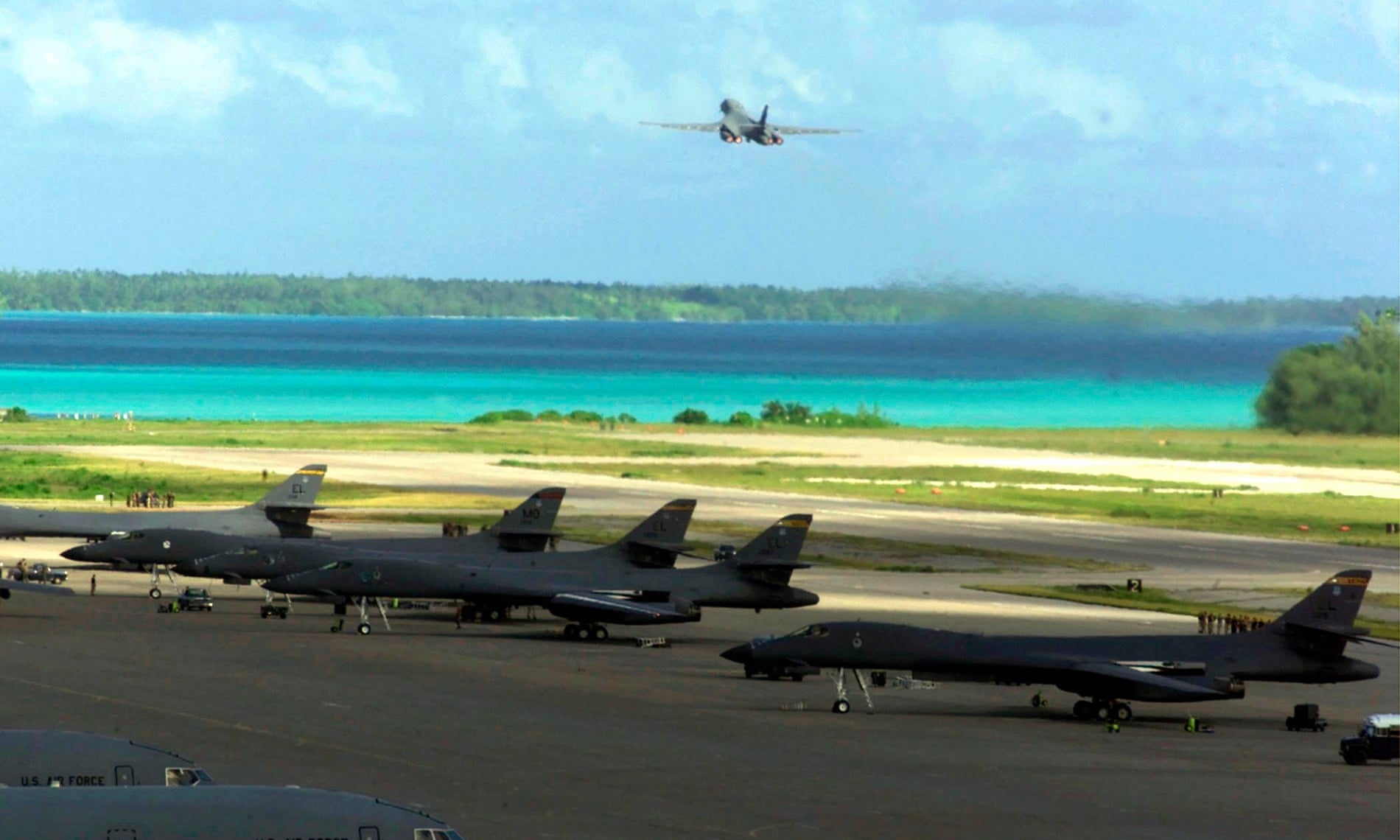
Diego Garcia, one of
the Chagos islands, has been a UK and US airbase since the 1960s and is
thought to be excluded from the right to return.
Photograph: Universal Images/Getty Images
From The Guardian by Haroon Siddique and Diane Taylor
Agreement to hand back UK’s last African colony follows 13 rounds of negotiations and international pressure
The UK has agreed to hand over the Chagos Islands to Mauritius, ending years of bitter dispute over Britain’s last African colony.

The agreement will allow a right of return for Chagossians, who the UK expelled from their homes in the 1960s and 1970s, in what has been described as a crime against humanity and one of the most shameful episodes of postwar colonialism.
However,
there will be an exception for the key island of Diego Garcia, which is
home to a joint UK-US military base, and which will remain under UK
control.
Plans for the base were the reason the UK severed the Chagos Islands from the rest of Mauritius when it granted the latter independence in 1968 and forcibly displaced up to 2,000 people.
Plans for the base were the reason the UK severed the Chagos Islands from the rest of Mauritius when it granted the latter independence in 1968 and forcibly displaced up to 2,000 people.
There
was a mixed reaction to the announcement from Chagossians, not all of
whom are happy that sovereignty has been handed to Mauritius.

source LOC

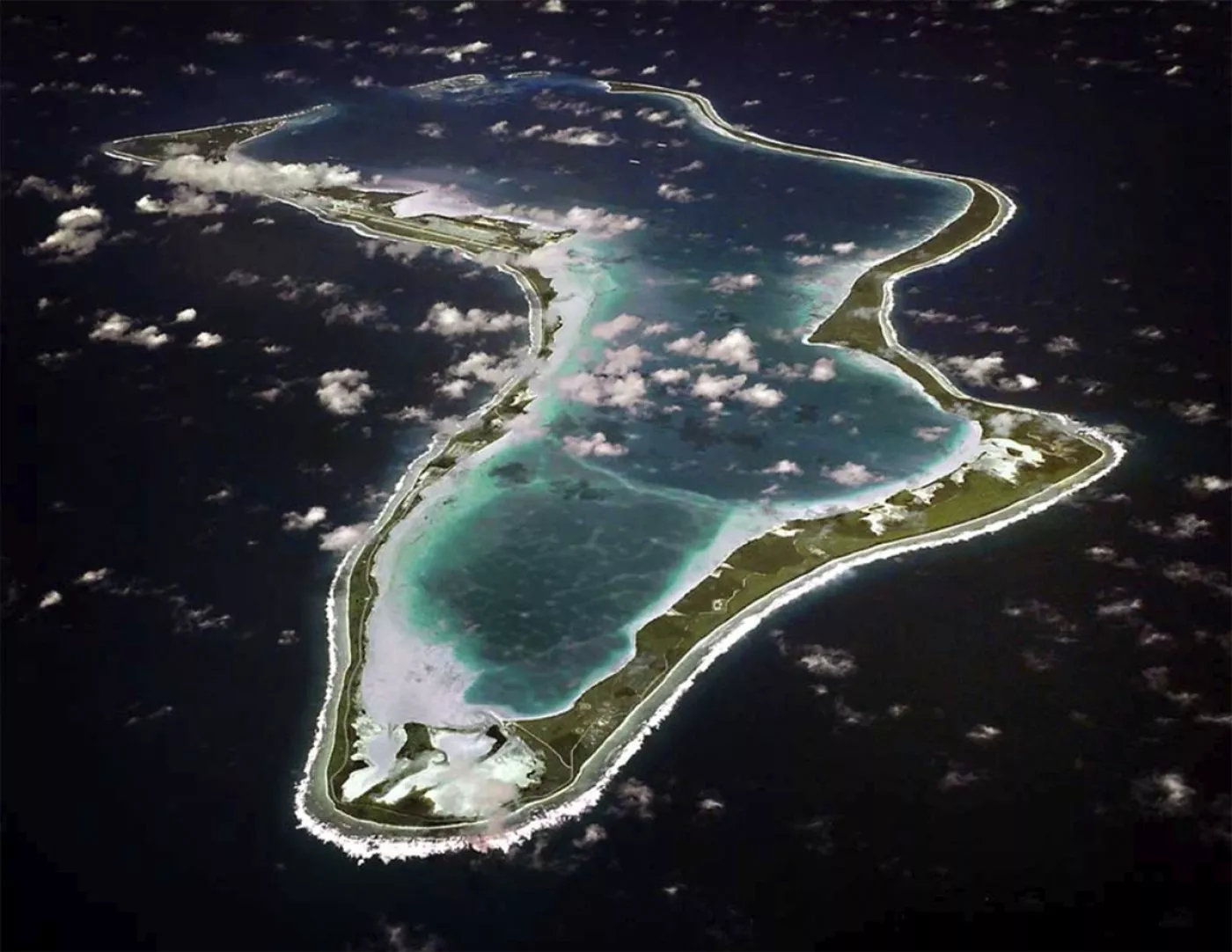
This image released by the U.S. Navy shows an aerial view of Diego Garcia in the Indian Ocean.
On October 3, the government of the United Kingdom announced that it will be authorized to exercise with respect to Diego Garcia the sovereign rights and authorities of Mauritius required to ensure the continued operation of the base on the island well into the next century.
But Olivier Bancoult, chair of the Chagos Refugee
Group, who was four years old when his family was deported to
Mauritius, welcomed it, describing it as “a big day”.
“This
has been a long struggle lasting more than 40 years and many of our
people have passed away,” said Bancoult, who had mounted a series of
legal challenges over the sovereignty of the islands in the UK courts
since 2000.
“But today is a sign of recognition of the injustice done against Chagossians who were forced to leave their homes.”
“But today is a sign of recognition of the injustice done against Chagossians who were forced to leave their homes.”
He
said it was not yet clear how many Chagossians would like to return to
the islands, many of which are uninhabitable.
While acknowledging that those born on the largest island – Diego Garcia – would not be able to return, he expressed hope that Chagossians could be prioritised for jobs there.
While acknowledging that those born on the largest island – Diego Garcia – would not be able to return, he expressed hope that Chagossians could be prioritised for jobs there.

Chagossian protest in central London against the depopulation of the islands.
Photograph: Pacific Press/LightRocket/Getty Images
Bancoult, who was part of a historic 2022 trip to
the islands, which included the Mauritian ambassador to the UN, Jagdish
Koonjul, raising his country’s flag
above the atoll of Peros Banhos in a ceremony, added: “If Mauritius
will not fulfil its responsibilities to us of course we will raise our
voices.”
The first of 13 rounds of
negotiations began in 2022, representing an abrupt change of approach
after years of the UK defying court rulings – including a 2019 advisory opinion from the UN’s highest court – and UN general assembly vote,
which all said it should return the islands to Mauritius.
The agreement is subject to a treaty that the parties will seek to conclude as soon as possible.
An attempt to halt the negotiations, on the basis that the Chagossians were not consulted or involved, failed.
Chagossian
Voices, a community organisation for Chagossians based in the UK and in
several other countries, said of Thursday’s announcement: “Chagossian
Voices deplore the exclusion of the Chagossian community from the
negotiations which have produced this statement of intent concerning the
sovereignty of our homeland.
Chagossians have learned this outcome from the media and remain powerless and voiceless in determining our own future and the future of our homeland.
Chagossians have learned this outcome from the media and remain powerless and voiceless in determining our own future and the future of our homeland.
“The
views of Chagossians, the Indigenous inhabitants of the islands, have
been consistently and deliberately ignored and we demand full inclusion
in the drafting of the treaty.”
A joint statement from the UK and Mauritius governments said the agreement would “address wrongs of the past and demonstrate the commitment of both parties to support the welfare of Chagossians”.
The UK foreign secretary, David Lammy, said the UK government had secured the future of the military base, while the US president, Joe Biden, welcomed the agreement as a “clear demonstration that … countries can overcome longstanding historical challenges to reach peaceful and mutually beneficial outcomes”.
Sunday, October 6, 2024
Neos Britannia close out the Louis Vuitton Cup winning 7-4 against Luna Rossa
see America'sCup
55.6 knots / 102.9 KM/H 💥 Meet Britannia the fastest ever yacht in an @americascup race 💪
— INEOS Britannia (@ineosbritannia) October 1, 2024
We go again tomo 👊#AmericasCup #LVCupFinal pic.twitter.com/1pyDL2Ra8T
note : the Race 8 (Oct. 1st) was the fastest sailing race ever :
In Garbi wind conditions of 18-21 knots with flat water, the INEOS Britannia AC75 hit a blistering top speed of 55.6 knots so 102.9 km/h
In Garbi wind conditions of 18-21 knots with flat water, the INEOS Britannia AC75 hit a blistering top speed of 55.6 knots so 102.9 km/h

Links :
Subscribe to:
Posts (Atom)