Saturday, December 21, 2013

Shackleton: death or glory


Navigation with sextant
Getting to grips with old methods of navigation is proving to be really tricky.
If the team miss South Georgia then they will be blown out into 3000 miles of open ocean.


Rough seas The team have a relentless battle to try and stay on course.
Battered by the wind and rough seas can the complete their mission or just get lost at sea?


Snow built up

Snow starts to fall as the temperature drops to below zero, it could mean trouble for the crew if the sails become too bogged down with the weight.

Links :

Friday, December 20, 2013

Brazil DHN update in the Marine GeoGarage

As our public viewer is not yet available (currently under construction, upgrading to Google Maps API v3 as v2 is officially no more supported),
this info is primarily intended to our Phone/iPad universal mobile application users (Marine Brazil on the App Store)
and also to our B2B customers which use our nautical charts layers in their own webmapping applications through our GeoGarage API.


13 charts have been updated since the last update + 1 new chart (PLANO4418 Plano Rio Trombetas)

DHN update December 19, 2013

  • 2102   DE SÃO JOSÉ DO NORTE AO CANAL DA SETIA
  • 231   DA ILHA DO MACHADINHO AO CABO MAGUARI (PROXIMIDADES DA BARRA SUL DO AMAZONAS)
  • 1830   PROXIMIDADES DO PORTO DE SÃO FRANCISCO DO SUL
  • 2101   PORTO DO RIO GRANDE
  • 21800   DA PONTA DE ITAPAGÉ A FORTALEZA
  • 21900   DA PONTA MACEIÓ AO CABO CALCANHAR
  • 25110   ILHA ELEFANTE E PROXIMIDADES
  • 25119   ILHAS SHETLAND DO SUL - BAÍA DE SERRATT (I. REI GEORGE)
  • 25120   ILHAS SHETLAND DO SUL - BAÍA REI GEORGE (I. REI GEORGE)
  • 202   DA ILHA DO BAILIQUE À PONTA DO CAPINAL
  • 232   BARRA SUL DO RIO AMAZONAS
  • 3357   DA VOLTA DO ACURIZAL AO RIACHO DO ABRIGO
  • 3358   DA ORÇADA DE SÃO JOSÉ À ILHA CARAGUATÁ

Today 434 charts (482 including sub-charts) from DHN are displayed in the Marine GeoGarage
Don't forget to visit the NtM Notices to Mariners (Avisos aos Navegantes)

Has the Great Barrier Reef just been approved for destruction by the Australian government?


From The Guardian (by Alex White)

One of the natural wonders of the world is about to have 3 million cubic metres of seabed dumped on top of it.

Who could forget, back in 2009, the launch of the "Best Job in the World"?
The campaign by Tourism Queensland generated global interest in the Sunshine State and the role of park ranger and "caretaker" of Hamilton Island in the Great Barrier Reef.
Ben Southall was the inaugural winner, a Brit by birth and native of Hampshire, he beat 35,000 applicants for the coveted role.
Ben spent a year promoting the wonders of the Great Barrier Reef.
In the first four days, he visited the pristine Whitehaven Beach, stopped for lunch at Hayman Island, went on a tour of the Coral Sea and Daydream Island and ended up at the Seaworld adventure park and a game of Aussie Rules (Richmond vs Adelaide - Go Crows!).
Four days into his year-long stint in the Best Job in the World, Ben said: "My stay on the Gold Coast has been nothing short of spectacular; there really is something for everybody."


Unfortunately, soon a massively destructive coal port will be built just 50 km north of the magnificent Whitsunday Islands.
The port expansion was approved by the Abbott Liberal National government on Wednesday 11 December, and it will become one of the world's largest coal ports.
The coal export facility is ironically located on Abbot Point.
The construction of this port will involve dredging 3 million cubic metres of seabed.
The dredge spoil will be dumped into the Great Barrier Reef World Heritage Area.


To give you an idea of the scale of this dredging, if all of the spoil was put into dump trucks, there would be 150,000 of them lined up bumper to bumper from Brisbane to Melbourne.
This expansion is further proof that the Abbott government is hell-bent on turning Australia into a reckless charco-state that solely represents the interests of fossil fuel and coal companies.
Just around the corner from the port is a beach that is the nesting place for endangered green and flat back turtles.
Fun facts about the flat back turtle: they're officially classified as "vulnerable" by the Australian Government, and nest only in northern Australia.
They have the smallest migratory range of any marine turtle, so when their home in Queensland is destroyed, they've really got nowhere else to go.
Also in the spoil-dumping area are sea-grass beds, which are the home to dugongs.
The "sea cows" may not be the sexiest of marine animals, but they are at risk of extinction, and most of the world's remaining population lives in the Great Barrier Reef.

 Landsat picture

 Pleiades - Great Barrier Reef coverage. The Great Barrier Reef (100 km wide) ...

This is one of the reasons that the Reef has World Heritage listing.
An independent government report from August this year found that dredging sediment travelled a lot further than previously thought.
The risks include sediment being disturbed by severe weather.
Even a cursory look at Queensland's weather patterns near the Reef over the past decade would show that severe weather, including tropical cyclones and flooding, is a regular occurrence, even if you disregard massively destructive events like Cyclone Yasi.

The Great Barrier Reef generated around 69,000 full-time equivalent jobs, and boosted our economy by 5.68 billion in 2011/12, according to recent research.
Most of this is through tourism and reef-dependent industries like fishing.
Environment Minister Greg Hunt has mischievously claimed that "Some of the strictest conditions in Australian history have been placed on these projects".
This is mischievous because, obviously, massively increasing coal exports at this time will do irreparable damage to our climate.


Worryingly, Greg Hunt's briefing and decision, released on the 11th of December, is based on the assurance of the North Queensland Bulk Ports Corporation, the state-owned corporation that owns the project, that "the project area (dredging area) is not a notable or significant biodiversity site in the Great Barrier Reef World Heritage Area" and "the potential impact area in the dumping ground (which is within the Great Barrier Reef World Heritage Area and the Great Barrier Reef Marine Park) is considerably small".
The brief also says that the "habitats were recorded to recover from similar events".
You are obviously free to come to your own views about Hunt's strange cognitive dissonance, where on the one hand there are the "strictest conditions" on the dredging, but on the other hand the "dredging area is not a notable... site" in the Reef.
Perhaps someone could leave a comment that explains why Hunt has required strict conditions if the area is not a significant site.
Unless of course, Hunt is simply trying to pull the wool over our eyes.
You be the judge.


The very real problems are not just the vast and untold damage that dredging will do to the Great Barrier Reef, or the risk of damage to the reef by the substantial increase in shipping through the World Heritage Area.
The Abbot Point development has been green-lit to funnel vast amounts of coal out of Australia.
The coal ports currently proposed, including Abbot Point and new coal terminals proposed at Wiggins Island, Raglan Creek, Balaclava Island, Dudgeon Point, and Cape York, would increase total coal tonnage by more than six-fold, from 156 Mt in 2011 to a capacity of 944 Mt by the end of the decade.
Australia's coal is one of the globe's fourteen carbon bombs.
Our coal export industry is the largest in the world, and results in 760m tonnes of CO2 emissions annually.
The urgent goal of Tony Abbott's government, and his environment minister Greg Hunt is to ship as much climate-devastating coal as possible, as quickly as possible.
Every day, this Liberal-National government, led by Tony Abbott, provides new examples of its nastiness, its short-sightedness, and its willingness to destroy livelihoods, communities and the environment to enrich coal barons.

Links :
  • SydneyMorningHerald : Mining dwarfs farming as threat to health of Great Barrier Reef, marine scientist warns

Thursday, December 19, 2013

NZ Linz nautical charts to be more accessible

As our public viewer is not yet available (currently under construction, upgrading to Google Maps API v3 as v2 is officially no more supported),
this info is primarily intented to our iPhone/iPad universal mobile application users (Marine NZ on the App Store)
and also to our B2B customers which use our nautical charts layers in their own webmapping applications through our GeoGarage API.

From Scoop

From 22 November 2013, Land Information Minister Maurice Williamson announced mariners can now access free online navigational charts in a new, and more widely accessible, format as the government continues to make more publicly held information available for reuse.

Land Information New Zealand today made its Raster Navigational Charts available in an unencrypted BSB (.kap) format that’s more widely supported by software manufacturers.

“This is great news for recreational boaters, who are much more likely to have on board systems that support the new format.  The change also removes the need for special licensing or permits,” Mr Williamson says.

Charts will also be available to software developers to use in creating apps and other types of value added products.
“LINZ maritime information is already being used to create apps for mariners, and this latest initiative only opens up even more possibilities for developers.
“Making Raster Navigational Charts accessible is another example of the work the government is doing to make non-personal data easier for people to discover, use and share,” Mr Williamson says.

Regarding the GeoGarage, the quality of the display for the Linz charts both on the web or on the Marine NZ iPhone/iPad universal application is right now improved as the resolution of the BSB material (254 dpi) is better than the unencrypted previous format HCRF (127 dpi) used in previous digital charts material.

181 charts (318 including sub-charts) available in the GeoGarage (catalogue).


Note : the 11 following charts are not available (Fathom charts) in the NZMariner catalogue of NZHA (New Zealand Hydrographic Authority) :
  • 82    Tonga
  • 822    Vava’u Group
  • 827    Approaches to Tongatapu including ‘Eua
  • 861    Plans in Samoa
  • 1414    Asau Harbour
  • 8235    Ofolanga Island and Anchorage
  • 8247    Ha’apai Group - northern portion
  • 8248    Ha’apai Group - southern portion
  • 8259    Nomuka Group
  • 8266    Anchorages in Tonga
  • 8685    Islands in American Samoa

The Whale: the terrifying real voyage that inspired Moby-Dick


From The Telegraph (By

Moby-Dick is the story of a captain driven mad in his pursuit of a whale.
But, as a new BBC drama reveals, the events that inspired Herman Melville were even more terrifying

Two thousand miles from the nearest land, the crew of the Essex watched in horror as the enormous bull whale headed for their mother ship.
Marooned in small, open boats the 20 men stood, powerless, as the creature struck their vessel at full speed.
Wood splintered, the whole structure of the ship shook.
Then, after swimming off to leeward, the whale gathered its strength and came thundering towards the Essex again, even faster than before.
As the crew floundered in the middle of the Pacific they knew their lives were in danger.
None, though, was prepared for the appalling choices they were going to have to make in the days and weeks that followed.

  Essex being struck by a whale on November 20, 1820 (sketched by Thomas Nickerson)
Credit: Nantucket Historical Association.

The story of the Essex and the lengths to which its crew went in order to survive is part of maritime lore and the subject of a new BBC film, dramatising the real-life voyage that inspired Herman Melville to write his novel Moby-Dick.
Starring Jonas Armstrong, best known for playing Robin Hood in the BBC series of the same name, The Whale promises to be both an action-packed drama and a disturbing portrayal of the human response to extreme hunger.
Also woven within the story will be a vivid depiction of the whaling industry.
In the early 19th century, whaling was probably the most unpleasant, dangerous and least rewarded of all occupations.
A whaler’s life was mired in blood and blubber, stalled by immense periods of boredom and often abruptly curtailed by violent death.
Signing on for a whaling voyage could mean up to five years away from home, and a journey to the other end of the Earth, in order to do battle with the great leviathan of the seas – the sperm whale.


 Illustration from an early edition (1892) of Moby-Dick (C. H. Simonds Co)
Author : A. Burnham Shute
 
Ever since 1712, when they had first set out from Nantucket, Yankee whalers had supplied the Western world with whale oil.
The streets of London, New York, Berlin and Paris were lit by it; the mills and machinery of the Industrial Revolution ran on the same stuff.
Whaleships were the equivalent of modern oil tankers, earning millions of dollars for the new republic and exporting its influence around the world.

It was this heroic, filthy, abusive and highly lucrative (for its shipowners) business that Melville recorded in Moby-Dick.
Published in 1851, his book was wildly digressive; 135 chapters filled with everything he knew about whales and whaling – a result of his own whaling voyages in the 1840s.
But much more than that, Moby-Dick became a kind of modern American myth, woven around the legendary battle between man and whale, incarnate in the figure of Captain Ahab.
The monomaniacal commander of the Pequod goes in search of the fantastical White Whale which had “dismasted” him, biting off his leg.
Now Ahab scours the South Seas, seeking revenge on the gigantic creature.
To land-bound readers of Moby-Dick, it must have seemed a far-fetched, if thrilling, tale.
Could a whale really attack and sink a great ship, as Moby Dick does in the final, apocalyptic chapters of Melville’s book?
The astonishing answer was yes.
And not only that, the gruesome details of the true story exceeded any fictional account.

The Whale: Trailer

Indeed, such is its resonant power, that the BBC drama is to be followed by another film version, In the Heart of the Sea, directed by Ron Howard and based on the book of the same name by Nathaniel Philbrick.
Even now, the story seems unbelievable. But for a first-hand account of those events, we can turn to the words of the men who lived through them – and survived to tell the tale.
On August 12 1819, the Essex, an 87ft, 238-ton whaleship, set sail from Nantucket.
The captain was George Pollard, a man whose subsequent experiences were destined to haunt him as much as his fictional counterpart Ahab, while his first mate, Owen Chase, became the role model for Ahab’s first mate, Starbuck (although better known now for the global chain of coffee shops named after him).

By November 1820, the Essex had reached the Pacific equator, 2,000 miles from the South American coast.
The voyage had been uneventful – until now.
That morning, November 20, the weather was fine and clear.
A pod of whales was sighted by the lookout.
The men set to with gusto – whales meant dollars, after all.
The slender, fast, clinker-built whaleboats, built to ride high in the water, were lowered from the sides of the ship, and the hunters set off in pursuit of their prey.

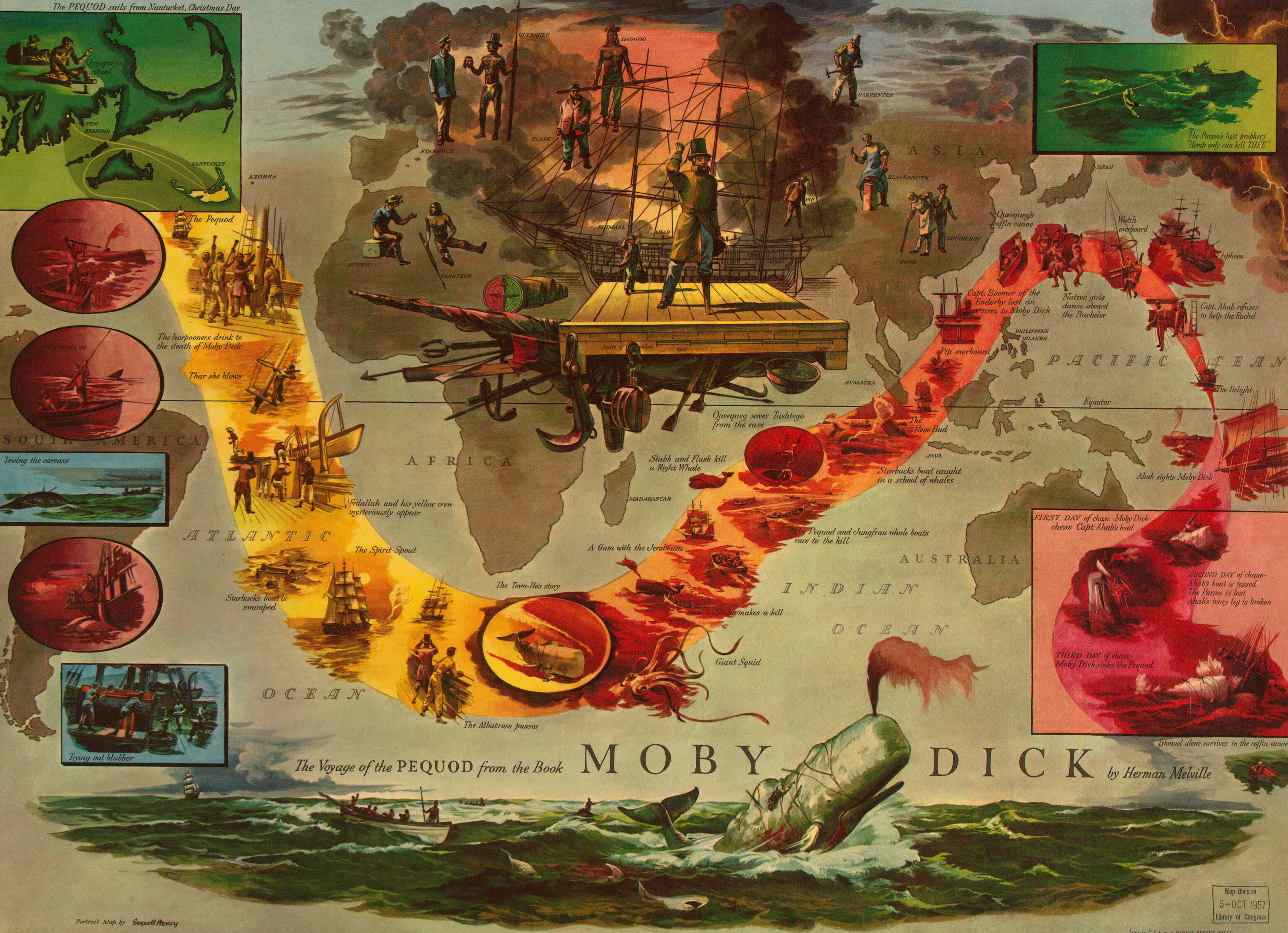
 The Voyage of the Pequod from the book Moby Dick by Herman Melville; one of a series of 12 literary maps based on British and American literature, produced by the Harris-Seybold Company of Cleveland between 1953 and 1964.
source : LOC

The sperm whale is no mean adversary.
It is the largest predator that ever lived, and although modern sperm whales grow to only 65ft, Melville and his fellow whalers recorded whales 80 or even 100ft long.
(Scientists think intensive hunting in the 19th century reduced the number of very large bull sperm whales, thereby affecting the overall size of the population, genetically. Hunting has also reduced the world population from 1.6 million to fewer than 360,000.)

Armed with a lower jaw studded with 42 teeth, it’s a formidable opponent if driven to defend itself. Its tail, as broad as a house, could dash a flimsy whaleboat to smithereens, and often did.
The sperm whale is also the only cetacean that can swallow a human being, and, again, has done so, albeit by accident, in the melee of a hunt.
(It’s not a nice way to go: its gastric juices are so acidic that sailors cut out of whales have been bleached white by the process.)

Modern Moby Dick : Documentary on White Sperm Whales

Yet this mammal is also highly social, sentient and communicative – it posseses the largest brain in nature.
And despite its size and power, it is extraordinarily placid, timid, even.
I’ve made a special study of the whale, in the writing of my books, Leviathan and The Sea Inside, and can attest to its overwhelmingly pacific nature.
But then, I’ve never come at one with a harpoon.

The crew of the Essex set upon the pod.
Owen Chase, at the prow of the whaleboat, threw his weapon into a whale.
“Feeling the harpoon in him, he threw himself, in agony, over towards the boat and, giving a severe blow with his tail, struck the boat,” Chase wrote in an account published in 1821.
Realising that if he didn’t act quickly, the whale might drag them down, Chase took an axe and cut the line.
At the same time, Captain Pollard was in his whaleboat, attempting to harpoon another large whale.
But then, to his amazement, Chase saw, much closer in, “a very large spermaceti whale about 85ft in length” heading directly at their mother ship, “as if fired with revenge” for the sufferings of its fellow whales.

Chase watched, horrified, as the whale “came down upon us at full speed, and struck the ship with his head, just forward of the fore-chains; he gave us such an appalling and tremendous jar, as nearly threw us all on our faces.
The ship brought up as suddenly and violently as if she had struck a rock, and trembled for a few seconds like a leaf.
”Even the whale appeared to have been dazed by the blow.
It lay motionless, briefly, before making off to leeward.
But then it “started off with great velocity”, Chase reported, “coming down apparently with twice his ordinary speed, and with tenfold fury and vengeance in his aspect”.
Its jaws were snapping together, and the surf flew as it thrashed the water with its tail.

I’ve seen sperm whales snap their jaws this way – it’s usually a sign of stress.
I’ve also been warned off from getting too close by the thundering slap of their muscular tails, usually because they were protecting a young calf.
Indeed, contemporary whale scientist Prof Hal Whitehead has speculated that the whale that attacked the Essex was defending its own young – it was a characteristic, cruel tactic of whalers to harpoon calves, in order to bring the more valuable adults within range.
Having said this, there are few incidents of sperm whales attacking ships; one of the only other recorded incidents was the one on the whaleship Ann Alexander in 1851, 31 years after the attack on the Essex.
Whatever the motive of this seeming monster, it rammed the ship with its head for a second time. This sickening blow was fatal for the vessel – with the sea gushing in its side, it was clear that the Essex was sinking.
Pollard, who had now returned to his stricken vessel, cried, “My God, Mr Chase, what is the matter?” “We have been stove by a whale,” came the answer.

 from Salariya

Hurriedly, the crew, all 20 of them, took to the three remaining whaleboats.
As the Essex sank, they rescued what they could: 6lb of hard bread; three casks of water; a musket, powder, tools; “and a few turtles”.
Chase also managed to salvage his sea chest – and with it, precious paper and pencil with which he would record their ordeal.

They also saved navigational materials – but it was in using these that Pollard and Chase made their great mistake.
They found that the nearest inhabited islands were the Marquesas, to the west.
But they feared that their natives were cannibals, and so decided to try the longer route, eastwards, to Chile.
It was a terrible irony, given what happened next.

Having fashioned sails, they set off in three boats.
They were at the mercy of currents and winds; often they drifted, lost on the infinite sea.
Chase calculated that their food would last 60 days – but the bread got soaked and, once dried, its saltiness merely increased the men’s thirst.
At night the boats would drift apart in the darkness, desperately signalling to each other with lanterns.
Suddenly, on December 20, a month after they had been wrecked, they sighted land, “a blessed vision like a basking paradise before our longing eyes”, as Chase put it.

But Henderson Island was no tropical paradise.
It contained little fresh water and they had soon killed all the birds they found, so on December 26 they decided to try to reach South America – now 3,000 miles distant.
Three men decided to stay on the island and take their chances there.
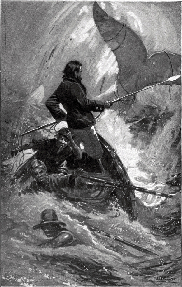
 Illustration (1902) of the final chase of Moby-Dick

Their fellow sailors were soon far out at sea.
Burnt by the blazing sun during the day, at night sharks swam about the boat, snapping as if to “devour the very wood”.
With only three days’ food left, extreme hunger was depriving the men of their “speech and reason”, wrote Chase.
They reconciled themselves to the inevitable.
“The black man, Richard Paterson, was perfectly ready to die.”
He did so of his own accord: six of the Essex’s crew were African-American, and none would survive.
But as Paterson’s body was committed to the deep, Chase realised that they couldn’t afford to jettison such a source of sustenance again.
As the next man, Isaac Cole, succumbed to madness and death – dying “in the most horrible and frightful convulsions I have ever witnessed” – the decision was made to eat him.
Cole’s body was dismembered, the flesh cut from his bones.
They sliced open his trunk and took out his heart.

“We now commenced to satisfy the immediate cravings of nature from the heart, which we eagerly devoured, and then ate sparingly of a few pieces of the flesh,” Chase wrote.
The rest they cut into strips and hung up to dry for future consumption.
They even roasted their victim’s organs on a fire made on a stone at the bottom of the boat.
Chase and the remaining crew had been reduced to savages, ironically more than any Pacific islander they had sought to avoid.
Their boat had become a charnel house: “We knew not then to whose lot it would fall next, either to die or be shot, and eaten like the poor wretch we had just dispatched.”
With morbid practicality, Chase worked out a gruesome formula: three men could live for seven days off one human corpse.

By now, the three boats had become separated.
One drifted off and was never heard of again.
In Captain Pollard’s boat three men died; all were eaten; all were black.
After this, the white men began drawing lots and Pollard was forced to watch as his own young nephew, Owen Coffin, drew the black dot.
Bowing to his fate, Coffin lay down his head on the gunwale, was shot, and consumed.

Cannibalism had saved the Essex’s survivors.
But at a price.
On February 18, after almost three months at sea, Chase’s boat sighted a sail – a London brig, the Indian.
Their rescuers were shocked at what they found, said Chase: “Our cadaverous countenances...with the ragged remains of clothes stuck about our sun-burnt bodies, must have produced an appearance affecting and revolting in the highest degree.”

Five days later, Pollard and the only other survivor in his boat, Charles Ramsdale, were rescued by the Nantucket whaleship the Dauphin.
It was claimed they were, “found sucking the bones of their dead mess mates, which they were loath to part with”.
They too were taken back to Valparaiso, from where a ship was sent to rescue the three men from Henderson Island.
They’d managed to survive on the scant water they’d found, fish, and a few birds.

Just eight of the Essex’s crew had survived.
All went back to sea but, amazingly, Pollard was shipwrecked a second time and never took command of another ship, “for all will say I am an unlucky man”.
Instead, he became a nightwatchman in Nantucket, wandering the island, haunted by his ordeal. When a writer asked him about his experiences, Pollard replied, “I can tell you no more – my head is on fire at the recollection.”
(A more macabre story also went around: that when asked if he’d known Owen Coffin, Pollard would answer, “Know him? Why, I et [sic] him!”)

Chase too was a guilt-ridden man.
His ghostwritten account was published in an attempt to capitalise on the story – or, perhaps, to set aright the more sensationalist versions.
Later, Thomas Nickerson, the 14-year-old cabin boy, produced his own account, claiming they had not eaten Cole.
Perhaps he sought to erase the memory by denial.

Chase could not forget, however.
As he aged, he stored supplies of food in his attic, as if he believed he might once more face starvation – and that terrible dilemma
 Plagued by headaches, he would cry, “Oh my head, my head”, and by the time he died in 1869 he had been declared insane.

Today the island of Nantucket is a quiet, reserved place.
The whalers have long since left its cobbled streets, though the mansions that the shipowners built from their bloody profits still stand.
Their blank, silent windows look out to sea, testament to the extraordinary horrors that those men of the Essex suffered, out on the infinite deep.

Links :


Wednesday, December 18, 2013

NOAA: New edition of New York harbor nautical chart provides post-Sandy updates


From NOAA

Ships, barges, ferries, and recreational boats in the busy New York Harbor will be able to navigate more safely thanks to an updated version of the harbor’s nautical chart recently issued by NOAA that includes data gathered in the navigational response to the damage caused by Sandy in October 2012.
The latest edition of Chart 12334 – New York Harbor includes new depth measurements and shoreline depictions.
“This new chart edition is the first product of a multi-year post-Sandy charting plan,” said Rear Admiral Gerd Glang, director of NOAA’s Office of Coast Survey.
“We have NOAA vessels and private contractors surveying coastal areas affected by Sandy through this year and next, acquiring the data we will use to update nearly two dozen East Coast nautical charts.
“It normally takes more than a year, and sometimes four years or more in very complicated areas, to create a new chart edition,” Glang said.
“In this case, we were able to use data we gathered to help the repair efforts at the Statue of Liberty, merge it with depth measurements collected by the U.S. Army Corps of Engineers, and push it ahead as a priority since the Port Authority of New York and New Jersey is so essential to the nation’s economy.”

NOAA Coast Survey cartographers put a high priority on updating the New York Harbor chart.

The new chart edition is the result of combined efforts of several federal agencies. Following up on its survey response immediately after the storm, NOAA began acquiring more post-Sandy hydrographic data in April.

A Coast Survey navigation response team, equipped with high-tech surveying equipment, searched for underwater storm debris and mapped the depths surrounding Liberty Island and Ellis Island.
The surveys helped the National Park Service, which was working to reopen the Statue of Liberty in time for Independence Day.
The NOAA team also surveyed nearby shipping channels and the Port Authority’s Global Terminal to provide more up-to-date navigational information for maritime commerce.

In all, the team surveyed more than 110 linear nautical miles, through 119 hours, collecting over 578 million depth measurements.
Data acquired by surveyors with the U.S. Army Corps of Engineers also contributed significantly to the new edition.
The new chart edition also has updated shoreline depictions, acquired by aerial photography from NOAA National Geodetic Survey’s Remote Sensing Division.
Chart 12334 – New York Harbor is now available as a paper Print-on-Demand nautical chart, as a free PDF digital download, and as a free raster navigational chart for electronic display systems.

The federal government will print the chart in traditional lithographic style for chart agents to sell starting later this month.
The corresponding electronic navigational chart ENC US5NY1C will be available for download in late January.

US NOAA update in the Marine GeoGarage

As our public viewer is not yet available (currently under construction, upgrading to Google Maps API v3 as v2 is officially no more supported),
this info is primarily intended to our iPhone/iPad universal mobile application users (Marine US on the App Store)

and also to our B2B customers which use our nautical charts layers in their own webmapping applications through our GeoGarage API.

20 charts have been updated in the Marine GeoGarage
(NOAA update November 2013)

  • 25640 ed45 Puerto Rico and Virgin Islands
  • 11301 ed30 Southern part of Laguna Madre
  • 11323 ed24 Approaches to Galveston Bay
  • 11405 ed12 Apalachee Bay
  • 11406 ed29 St.Marks River and approaches
  • 11495 ed38 St. Johns River Dunns Creek to Lake Dexter
  • 11498 ed16 St. Johns River Lake Dexter to Lake Harney
  • 11507 ed39 Intracoastal Waterway Beafort River to St. Simons Sound
  • 12237 ed43 Rappahannock River Corrotoman River to Fredericksburg
  • 12334 ed42 New York Harbor Upper Bay and Narrows-Anchorage Chart
  • 13275 ed16 Salem and Lynn Harbors; Manchester Harbor
  • 14836 ed34 Ashtabula Harbor
  • 14864 ed44 Harrisville to Forty Mile Point;Harrisville Harbor;Alpena;Rogers City and Calcite
  • 14869 ed22 Thunder Bay Island to Presque Isle;Stoneport Harbor;Resque Isle Harbor
  • 16300 ed38 Kuskokwim Bay;Goodnews Bay
  • 17320 ed40 Coronation Island to Lisianski Strait
  • 17428 ed46 Revillagigedo Channel. Nichols Passage. and Tongass Narrows;Seal Cove;Ward Cove
  • 17430 ed36 Tongass Narrows
  • 18521 ed18 Columbia River Pacific Ocean to Harrington Point; Ilwaco Harbor
  • 18523 ed52 Columbia River Harrington Point to Crims Island
Today 1024 NOAA raster charts (2166 including sub-charts) are included in the Marine GeoGarage viewer.


How do you know if you need a new nautical chart?
See the changes in new chart editions.
NOAA chart dates of recent Print on Demand editions

Note : NOAA updates their nautical charts with corrections published in:
  • U.S. Coast Guard Local Notices to Mariners (LNMs),
  • National Geospatial-Intelligence Agency Notices to Mariners (NMs), and
  • Canadian Coast Guard Notices to Mariners (CNMs)
While information provided by this Web site is intended to provide updated nautical charts, it must not be used as a substitute for the United States Coast Guard, National Geospatial-Intelligence Agency, or Canadian Coast Guard Notice to Mariner publications

Please visit the
NOAA's chart update service for more info.

The coldest place in the world identified by satellite


From NASA


What is the coldest place in the world?

It is a high ridge in Antarctica on the East Antarctic Plateau where temperatures in several hollows can dip below minus 133.6 degrees Fahrenheit (minus 92 degrees Celsius) on a clear winter night -- colder than the previous recorded low temperature.


Scientists at the National Snow and Ice Data Center made the discovery while analyzing the most detailed global surface temperature maps to date, developed with data from remote sensing satellites including the MODIS sensor on NASA's Aqua satellite, and the TIRS sensor on Landsat 8, a joint project of NASA and the U.S. Geological Survey (USGS).

The researchers analyzed 32 years of data from several satellite instruments that have mapped Antarctica's surface temperature.
Near a high ridge that runs from Dome Arugs to Dome Fuji, the scientists found clusters of pockets that have plummeted to record low temperatures dozens of times.
The lowest temperature the satellites detected -- minus 136 F (minus 93.2 C), on Aug. 10, 2010.

The new record is several degrees colder than the previous low of minus 128.6 F (minus 89.2 C), set in 1983 at the Russian Vostok Research Station in East Antarctica.
The coldest permanently inhabited place on Earth is northeastern Siberia, where temperatures dropped to a bone-chilling 90 degrees below zero F (minus 67.8 C) in the towns of Verkhoyansk (in 1892) and Oimekon (in 1933).


At the coldest spots on Earth, every breath is painful.
But how cold can it get on Earth's surface?
What sort of weather brings on the record-breaking cold?

On the high plateau of East Antarctica, there is a ridge along the ice sheet nearly 14,000 feet above sea level.
The dry atmosphere and the long, sunless winter months combine to make this the coldest place on earth.
Under the clear Antarctic night skies the snow surface radiates warmth into space, cooling the air just above the surface.
As the air cools, it gets denser and starts to slide down the slope off of the ridge.
It collects In small hollows just a little downhill and continues to be cooled as the snow in the hollow radiates away its small amount of warmth.

The MODIS sensor on NASA's Aqua satellite allowed researchers from the National Snow and Ice Data Center to find the coldest place on Earth.
By turning to the TIRS sensor on the NASA/USGS Landsat 8 satellite, with its higher spatial resolution, the scientists were able to confirm how the topography facilitates these record low temperatures.

Links :
  • BBC :  Coldest spot on Earth identified by satellite
  • Phys.org : Building a telescope in the coldest place on Earth

Tuesday, December 17, 2013

Canada CHS update in the Marine GeoGarage

As our public viewer is not yet available (currently under construction, upgrading to Google Maps API v3 as v2 is officially no more supported),
this info is primarily intended to our B2B customers which use our nautical charts layers in their own webmapping applications through our GeoGarage API.

48 charts have been updated (November 29, 2013) in the GeoGarage platform :
    • 1202 CAP ÉTERNITÉ À/TO SAINT-FULGENCE
    • 1209 SAINT-FULGENCE À / TO RIVIÈRE SHIPSHAW
    • 1226 MOUILLAGES ET INSTALLATIONS PORTUAIRES / ANCHORAGES AND HARBOURS INSTALLATIONS / HAUTE CÔTE-NORD
    • 1230 PLANS PÉNINSULE DE LA GASPÉSIE
    • 1315 QUÉBEC À/TO DONNACONA
    • 1316 PORT DE QUÉBEC
    • 1317 SAULT-AU-COCHON À/TO QUÉBEC
    • 1430 LAC SAINT-LOUIS
    • 1509A RIVIÈRES DES PRAIRIES
    • 1509B RIVIÈRES DES PRAIRIES
    • 1510A LAC DES DEUX MONTAGNES
    • 1510B LAC DES DEUX MONTAGNES
    • 2029A COUCHICHING LOCK TO BIG CHUTE / ÉCLUSE DE COUCHICHING
    • 2029B BIG CHUTE TO / À PORT SEVERN
    • 2067 HAMILTON HARBOUR
    • 2100 LAKE ERIE / LAC ÉRIÉ
    • 2110 LONG POINT BAY
    • 2120 NIAGARA RIVER TO/À LONG POINT
    • 2283A OWEN SOUND TO/À GIANTS TOMB ISLAND
    • 2283B OWEN SOUND TO/À GIANTS TOMB ISLAND
    • 3443 Thetis Island To/À Nanaimo
    • 3475 PLANS - STUART CHANNEL
    • 3478 SANSUM NARROWS
    • 3490 FRASER RIVER/FLEUVE FRASER - SAND HEADS TO/À DOUGLAS ISLANDS BC
    • 3548 QUEEN CHARLOTTE STRAIT (CENTRAL PORTION/PARTIE CENTRALE)
    • 4012 YARMOUTH TO/À HALIFAX
    • 4013 HALIFAX TO / À SYDNEY
    • 4015 SYDNEY TO/À SAINT-PIERRE
    • 4022 CABOT STRAIT AND APPROACHES / DÉTROIT DE CABOT ET LES APPROCHES
    • 4233 CAPE CANSO TO / À COUNTRY ISLAND
    • 4235 BARREN ISLAND TO/À TAYLORS HEAD
    • 4236 TAYLORS HEAD TO/À SHUT-IN ISLAND
    • 4237 APPROACHES TO / APPROCHES DE HALIFAX HARBOUR
    • 4279 BRAS D'OR LAKE
    • 4281 CANSO HARBOUR AND APPROACHES / ET LES APPROCHES
    • 4308 ST. PETERS BAY TO/À STRAIT OF CANSO
    • 4320 EGG ISLAND TO / À WEST IRONBOUND ISLAND
    • 4363 CAPE SMOKEY TO/À ST PAUL ISLAND
    • 4385 CHEBUCTO HEAD TO/À BETTY ISLAND
    • 4406 TRYON SHOALS TO/À CAPE EGMONT
    • 4422 CARDIGAN BAY
    • 4432 ARCHIPEL DE MINGAN
    • 4450 SAINT PAUL ISLAND
    • 4641 PORT AUX BASQUES AND APPROACHES / ET LES APPROCHES
    • 4823 CAPE RAY TO\À GARIA BAY
    • 4921 PLANS-BAIE DES CHALEURS / CHALEUR BAY - CÔTE NORD / NORTH SHORE
    • 5505 BÉLANGER ISLAND À/TO COTTER ISLAND
    • 6206 SEVEN SISTERS FALLS TO/À SLAVE FALLS
      So 689 charts (1662 including sub-charts) are available in the Canada CHS layer. (see coverage)

      Note : don't forget to visit 'Notices to Mariners' published monthly and available from the Canadian Coast Guard both online or through a free hardcopy subscription service.
      This essential publication provides the latest information on changes to the aids to navigation system, as well as updates from CHS regarding CHS charts and publications.
      See also written Notices to Shipping and Navarea warnings : NOTSHIP

      Enric Sala: Saving the world's oceans one at a time

      Think of the ocean as our global savings account -- and right now, we're only making withdrawals, not deposits.
      Enric Sala shows how we can replenish our account through no-take marine reserves, with powerful ecological and economic benefits.

      From CNN

      When Enric Sala dips his toes in a pool of water, he does so in the knowledge he may well be the first man on the planet to do so.


      As he lowers himself below the surface of the ocean in his diving gear he becomes something of a fish whisperer, an underwater pied piper.
      In short, marine life flocks to the pony-tailed Spaniard.
      "It's an amazing experience to see fish that have never seen humans," he says.
      "They come really, really close to us. That's just unthinkable where people are fishing. Normally, we're used to them swimming away from us."
      "What we're doing is hard to do almost anywhere in the world. We're seeing large fish and sharks in almost every dive. People could spend years in, say, the Caribbean and see less sharks than we can in just one single dive. This latest trip has been a really, really special experience. It's so wild and we expected to see healthy reefs but not like this."

      National Geographic Pristine Seas Expeditions | Underwater message

      Sala is a novelty -- well, certainly to sea life -- with his passion for untouched waters as National Geographic's explorer-in-residence, whose mission is to help protect the last wild places in the ocean.
      The society's "Pristine Seas" initiative has been set up to fend off the long-distance fishing fleets that have started to encroach in these remote waters.

      Just 2% of the world's waters are protected, and Sala knows he has a gargantuan task ahead of him that needs massive backing by the world's governments.
      Slowly but surely he is chipping away at ensuring a better future for the world's waters.
      Of the eight areas he has so far visited under the program, four are now protected with a further two currently pending protection.

      His most recent expedition is to New Caledonia, an archipelago that separated from Australia 60-85 million years ago, coming to rest 1,210 kilometers east, and is now a special collectivity of France at the behest of Napoleon III, who ordered his navy to take formal possession of the 18,500 km².
       A day's boat ride north from New Caledonia's most northern tip, the Waitt's Institute research vessel has, until recently, been bobbing for the last three weeks slowly on the water's surface.
      A team of 12 people, made up of scientists, cameramen and crew, with Sala at the epicenter as expedition leader.
      Previously an academic, he recalls: "I was studying the effects of humans on the ocean. It was so depressing. I thought saving the ocean was a lost battle but then I decided I wanted to be part of the solution, so we started the Pristine Seas project.
      "Now I feel like there's hope. Now I go to these places and see what it used to be like, to see what the future could be elsewhere with regeneration."


      Sala's passion for all things underwater is addictive, he talks with a childlike enthusiasm for his current expedition.
      He was a boy when first captivated by the magic of the sea, inspired by the famous former diver and explorer Jacques Cousteau.
      "Since I can remember, my dream was to be a diver on his boat but I was born too late for that. But now I'm getting to do something similar myself. He showed us a lot and in later years showed us what was wrong with what we were doing. I'm trying to go one step beyond that and find solutions."
      So how would his idol have perceived what Sala and his team are now doing?
      "I think he would have been proud of what we're doing," says Sala, who grew up on the Spanish Mediterranean coast.
      "If he had lived on, I think he would have done something like this himself. But he was just an amazing man known by so many people around the world."

      Sala's current quest is aimed at not just protecting certain waters but regenerating those that have been fished to within an inch of their lives.
      The aim is to ensure protected areas become increasingly rich in fish and other underwater life, thereby spilling into other waters as it becomes overly abundant, thus in the long-term having a positive knock-on effect to fishermen.


      But he and his team are also learning about healthy coral and reef, among other things, to learn how to help regenerate damaged varieties in other global waters.
      Their days are spent diving, filming, photographing and researching.
      Sala, indeed, is most at home in the ocean.
      "Once in the water, all the problems on the surface disappear," he insists.
      "You're in a world where you're in complete focus but also at peace. It's a world where you don't feel the strong gravity from the planet, you feel like you're flying.
      "It completely changes your perspective on the world. I think it probably helps that endorphins are being released especially in these pristine places.
      "Being able to experience nature, and raw nature at that, first hand is like going back in the past. On these trips, it's like I go into a time machine and go back. It's quite spiritual."

      Sharks have become synonymous with fear in the sea, thanks in part to Steven Spielberg's "Jaws" film with John Williams' ominous stringed musical buildup to each unwitting victim of a shark attack.
      But Sala's experience of the underwater predators has been the complete antithesis.
      "Every moment is wonderful, like spending just one dive following clown fish for the whole dive," he says. "All the animals are special but the most special are sharks.
      "They are just so beautiful and elegant in the water. They're perfect in their environment and their shape has not really changed in 300 million years.
      "They are also great for the health of the reef, and the idea that they are dangerous is wrong. They have a bad reputation but in my five years doing this, diving sharks, I've not had one problem. I've never once been threatened by sharks."

      His long-term aim, and that of National Geographic, is to protect 20 seas in total. So how exactly can you protect large swathes of water?
      "It's become much easier as governments who we've worked with pass laws limiting the areas that can be fished," he explains.
      "Obviously some of these are in remote waters so the best way to do that is via satellite. For example in New Caledonia, we found out that the French Navy had intercepted an illegal Chinese fishing vessel. Having a naval presence is also a great deterrent."
      Next on his tick list is Mozambique in April.
      Slowly, sea by sea he is clearing up the planet's waters, and he is determined to continue.


      Monday, December 16, 2013

      Real-time world winds animated map

      A visualization of global weather conditions forecast by supercomputers updated every three hours
      created by Cameron Beccario (project under MIT license)
      animated picture : Dan Stuckey 

      This 'real time' app shows wind speeds...and among several map projections.


      Above: wind velocities at an altitude of 5,000 meters atop an Atlantis projection


      Weather Data | Global Forecast System (GFS model) : NCEP / US National Weather Service / NOAA
      (simple bilinear interpolation to fill the gaps)
      (with GRIB Decoder | UCAR/Unidata THREDDS)
      Geographic Data | Natural Earth
      Inspiration | HINT.FM wind map

      1000 hPa | ~100 m, surface conditions
       (zoom view via double click)

      The "earth" button also offers some options – changing the height (parameterized by pressure: e.g. the high-altitude 10 hPa pressure winds are more uniform, stronger, and red, purple, or even white if too strong), projection of the terrestrial sphere, changing the reference time (yesterday, forecast for tomorrow with date and time in the URL : earth.nullschool.net/#2013/12/18/0600Z/), UTC vs local time, visualizing your current location (a "cross" closes the local info), and more.
      Left-clicking a place (with no dragging) gives you some local wind speed and direction information about the place.

      Atmospheric pressure corresponds roughly to altitude
      several pressure surfaces are meteorologically interesting
      note: 1 hectopascal (hPa) ≡ 1 millibar (mb)

      so other layers :
        850 hPa | ~1,500 m, planetary boundary, low
        700 hPa | ~3,500 m, planetary boundary, high
        500 hPa | ~5,000 m, vorticity
        250 hPa | ~10,500 m, jet stream
          70 hPa | ~17,500 m, stratosphere
          10 hPa | ~26,500 m, even more stratosphere

       to beyond the stratosphere : the winds are fast, loopy and quite strange.


      Strong Storm in China, Korea and Japan this week-end illustrated by the new viewer

      Links :