Saturday, April 21, 2018

Bodies remodeled for a life at sea

Indonesian divers have evolved bigger spleens to hunt underwater
Researchers have found that Indonesia’s Bajau people, who for generations have spent the majority of their days diving and hunting underwater, also have genetic adaptations for their unusual lifestyle.

From NYTimes by Carl Zimmer

We are the products of evolution, and not just evolution that occurred billions of years ago.
As scientists peer deeper into our genes, they are discovering instances of human evolution in just the past few thousand years.
People in Tibet and Ethiopian highlands have adapted to living at high altitudes, for example.
Cattle-herding people in East Africa and northern Europe have gained a mutation that helps them digest milk as adults.


A Bajau diver spearfishes in Sulawesi.
A study suggests these sea-dwelling people have evolved adaptations to deep diving. Credit Melissa Ilardo

On Thursday in the journal Cell, a team of researchers reported a new kind of adaptation — not to air or to food, but to the ocean.
A group of sea-dwelling people in Southeast Asia have evolved into better divers.

The Bajau, as these people are known, number in the hundreds of thousands, scattered in communities in Indonesia, Malaysia and the Philippines.
They have traditionally lived on houseboats; in recent times, they’ve also built houses on stilts in coastal waters.
“They are simply a stranger to the land,” said Rodney C. Jubilado, a University of Hawaii anthropologist who studies the Bajau but was not involved in the new study.

The Bajau people number in the hundreds of thousands and live in houseboats and houses on stilts scattered across Indonesia, Malaysia and the Philippines.
Credit Melissa Ilardo

Dr. Jubilado first encountered the Bajau while growing up on Samal Island in the Philippines.
They made a living as divers, spearfishing or harvesting shellfish.
“We were so fascinated that they could stay underwater much longer than us local islanders,” Dr. Jubilado said.
“I could see them literally walking under the sea.”

Even as anthropologists study Bajau culture, biologists have grown curious about them, too.
Bajau divers been observed plunging more than 200 feet underwater, their only protection a pair of wooden goggles — a physiological marvel.

In 2015, Melissa Ilardo, then a graduate student in genetics at the University of Copenhagen, heard about the Bajau.
She wondered if centuries of diving could have led to the evolution of traits that made the task easier for them.
“It seemed like the perfect opportunity for natural selection to act on a population,” said Dr. Ilardo.

Her first step was to travel to Sulawesi, Indonesia, and then to a coral reef island where she reached a Bajau village.
After she proposed her study, they agreed to the plan.
She returned a few months later, this time with a portable ultrasound machine to measure the size of the Bajau people’s spleens.

Dr. Melissa Ilardo taking an ultrasound scan of a Bajau diver’s spleen.
Scientists have found that marine mammals with larger spleens can dive deeper — the enlarged spleen acts much like a bigger scuba tank
CreditPeter Damgaard

When people plunge into water, they respond with the so-called diving reflex: the heart rate slows and blood vessels constrict as a way to shunt blood to vital organs.
The spleen also contracts, squirting a supply of oxygen-rich red blood cells into the circulation.

All mammals have a diving reflex, but marine mammals like seals have a particularly strong one. Scientists suspect that the reflex helps them dive deeper — as it turns out, seals with bigger spleens can dive deepest. An enlarged spleen seems to function like a bigger scuba tank.

Dr. Ilardo scanned the abdomens of the Bajau villagers and then traveled about 15 miles inland to a village occupied by farmers known as the Saluan.
She scanned them, too.
When Dr. Ilardo compared scans from the two villages, she found a stark difference.
The Bajau had spleens about 50 percent bigger on average than those of the Saluan.

Yet even such a remarkable difference might not be the result of evolution.
Diving itself might somehow enlarge the spleen.
There are plenty of examples of experience changing the body, from calloused feet to bulging biceps.

Only some Bajau are full-time divers.
Others, such as teachers and shopkeepers, have never dived.
But they, too, had large spleens, Dr. Ilardo found.
It was likely the Bajau are born that way, thanks to their genes.

Bajau homes built on stilts.
Only some Bajau are full-time divers, while others are teachers and shopkeepers, but Dr. Ilardo found that all Bajau had enlarged spleens.
Credit Melissa Ilardo

On her visit to Sulawesi, Dr. Ilardo also took mouth swabs from the Bajau and Saluan from which she extracted DNA.
She looked at the genetic variations in each village and compared them to people from neighboring countries, such as New Guinea and China.

A number of genetic variants have become unusually common in the Bajau, she found.
The only plausible way for this to happen is natural selection: the Bajau with those variants had more descendants than those who lacked them.
One variant of a gene called PDE10A influenced the size of spleens in the Bajau.
People with one copy of the mutant gene had bigger spleens than those with none. People with two copies had even bigger spleens.
Scientists had never found a special role for PDE10A in the spleen.
“This connection was a bit bizarre,” Dr. Ilardo said.

But there’s one possible link.
PDE10A has been shown to control the level of thyroid hormone in the body.
And scientists have found that injecting thyroid into mice with stunted spleens can make the organs grow larger.
Still, that wouldn’t pin down exactly how PDE10A became so common in the Bajau.
“It’s the question that’s harder than others,” said Rasmus Nielsen, a geneticist at the University of California, Berkeley, who collaborated with Dr. Ilardo.

A diver with a traditional wooden mask.
Some researchers suspect the Bajau only began diving when Chinese demand for sea cucumbers rose in the 1600s.
Other experts believe the Bajau began earlier, at the end of the last Ice Age, when rising sea levels turned the region into islands.
Credit Melissa Ilardo

For her own part, Dr. Ilardo suspects that natural selection favored the Bajau variant of PDE10A because deep diving is so risky.
“I would think, as morbid as it is, that if they didn’t have this, it would kill them,” she said.

François-Xavier Ricaut, an anthropologist at the University of Toulouse who was not involved in the study, said that it wasn’t clear yet how quickly this evolutionary change happened.
Some researchers suspect the Bajau only began diving to great depths when a market for sea cucumbers opened up in China in the 1600s.
Or perhaps the adaptation began thousands of years earlier, at the end of the Ice Age, when rising sea levels turned the region around Indonesia into islands.
“This study acts as a cornerstone for exciting questions to follow,” said Dr. Ricaut.

Dr. Ilardo said there were likely a number of other genes that help the Bajau dive.
She and her colleagues also found evidence for natural selection on a gene called BDKRB2.

In a study published last year, Russian scientists discovered that it plays a role in the diving reflex.
In people with variants of BDKRB2, blood vessels are more tightly constricted when they plunge their faces into cold water.

To see if that’s the case with the Bajau, Dr. Ilardo will need to take another trip to beautiful Sulawesi. “I would be happy doing this as long as I can,” she said.

Links :

Friday, April 20, 2018

Nautical raster charts layers in the GeoGarage platform

GeoGarage cloud-based nautical charts streaming platform :
17 layers with raster chart material derivated from international Hydrographic Offices

U-Boat rumoured to have helped Nazis escape to Argentina is discovered

Computer-generated image of how researchers believe U-3523
sunk off the Danish coast on May 6 1945
Sea War Museum Jutland in Thyborøn has made a new sensational discovery during its continued registration of shipwrecks in the North Sea and Skagerrak.
In April 2018, the museum found the wreck of the German submarine U-3523, which was sunk with waterbombs in Skagerrak by a British B24-Liberator aircraft on May 6, 1945.
Just the day before, the German forces in Denmark, Northwest Germany and Holland had surrendered, so the submarine was not engaged in battle, but was probably on its way to Norway.
The U-3523 was of the new and highly advanced type XXI that could have revolutionized the submarine war if enough boats had been completed in due time.
118 boats were in the process of being build, but only two came into active service, and none was ever engaged in battle.
U-3523 appeared on the survey screen during the museum's scan of the seabed some ten miles north of Skagen, and the discovery was very surprising.
Very unusually, the entire submarine bow is buried in the seabed while the stern is approximately 20 meters above the sea bottom.
The wreck lies at 123 metres of water depth, making it very difficult to access.

From The Independant by Adam Lusher

The sophisticated German submarine U-3523 might have been the perfect vehicle for getting Nazi loot and leaders to South America - but its wreck has been found off the coast of Denmark

A submarine linked to rumours that Adolf Hitler survived and escaped to Argentina in a U-boat has been discovered – lying wrecked at the bottom of the North Sea between Denmark and Norway.

 Position of the U-3523 U-Boat
(DailyMail image)

Sea War Museum Jutland says it has no plans to raise the sunken U-3523 U-boat,
which is sitting at a depth of 123 metres, located 10 NM North of Skagen (DK) in the Skagerrak strait
not far from the position given by the British Air Force in 1945.
Sunk 6 May 1945 at 1839hrs in the Skagerak northeast of Skagen Horn, Denmark, in position 57.52N, 10.49E, by depth charges from a British B-24 Liberator bomber (RAF Sqdn. 86/G)
visualization of a DGA nautical chart in the GeoGarage platform

Submarine U-3523 had been one of a new generation of type XXI U-boats that were able to run more silently and stay submerged for longer than any of their predecessors, with a range that would have allowed them to sail non-stop from Europe to South America.

A U-3008 another Type XXI submarine and sister vessel of the U-3523
taken over by the US Navy April 15, 1948

Close up of Type XXI U-Boat conning tower, shortly after VE Day - 1945

As such it would have been perfect escape vessel for Nazi gold, high-ranking officials or even Hitler himself as the Reich collapsed at the end of the Second World War.

And although the British crew of a B24 Liberator bomber reported sinking the sub on May 6 1945, its wreck was never found, helping support suspicions that the U-boat, and whoever it was carrying, might have got away to Argentina.
Now, however, researchers from the Sea War Museum Jutland, Denmark, say they have discovered the wreck of U-3523 in the Skagerrak strait, ten nautical miles north of the north Danish town of Skagen.

The discovery seems to prove that U-3523 never took Hitler, any Nazis or any treasure to Argentina.
The real reason it lay undiscovered for 73 years, the researchers say, is because the Liberator bomber crew made a mistake in reporting its position, placing the wreck nine nautical miles east of where it had actually sunk.
But, intriguingly, the researchers also say that U-3523 probably had been “on the run” when the Liberator cut short its escape, and they still don’t know for certain who was on board when the submarine sank.

A statement issued by the Sea War Museum said: “The day before [U-3523 was sunk] German forces in Denmark, Northwest Germany and the Netherlands had surrendered, and the U-boat was not on a war patrol, but probably on the run.
“After the war, there were many rumours about top Nazis who fled in U-boats and brought Nazi gold to safety, and the U-3523 fed the rumours.
“The Type XXI was the first genuine submarine that could sail submerged for a prolonged time, and the U-3523 had a range that would have allowed it to sail non-stop all the way to South America.
“But nobody knows if this was the U-boat’s destination, and nobody knows if the U-boat had valuables or passengers aboard in addition to the 58 crew, all of whom perished at 123 meters depth.”

The final telegram sent by the submarine, on 5 May 1945, made no mention of Nazi treasure or officials, so there probably needs to be considerable scepticism about whether skipper Willi Müller and his crew were carrying Nazi passengers instead of just trying to escape themselves.

And as for Adolf Hitler, the U-boat appears to have left port five days after 1 May 1945, when German radio announced the Fuhrer’s death.

But the fact is that some Nazis including Adolf Eichmann and Dr Josef Mengele, the “angel of Death” of Auschwitz, did make it to Argentina, Eichmann to be captured by the Israelis in 1960, Mengele to live out his days in freedom until drowning while swimming off Brazil in 1979.
And although men like Eichmann and Mengele got away on conventional passenger ships, two German submarines are known to have turned up in Argentina some months after the war in Europe ended on May 8 1945.

U-530 surrendered to the Argentine navy at Mar del Plata on July 10 1945.
Its captain Otto Wermuth insisted he hadn’t carried any passengers, but his Argentine navy interrogators noted that he admitted destroying the submarine’s log book and secret documents, while consistently refusing to give details about the specific routes taken.

Later news articles suggested that an Argentine reporter claimed to have seen a provincial police report which supposedly documented a strange submarine landing a high-ranking officer and civilian. It was even suggested that the pair might have been Hitler and his lover Eva Braun in disguise.

And about a month later, on August 17 1945, another submarine, U-977, turned up in Mar del Plata.
The submarine crew told interrogators that after realising the war was over in May, they had headed for Argentina, hoping to avoid falling into the hands of the Russians and maybe even to settle in South America without being sent to a POW camp.

They had also been influenced by Nazi propaganda claims that after the war all German men would be enslaved and forcibly sterilised by the victorious Allies.

What the submarine had been doing between early May and arriving in Argentina in August was explained by factors like taking evasive action after spotting or being spotted by planes and ships, and by a stop off at the Cape Verde Islands, where the men swam and sang songs.
Skipper Heinz Schäffer, like Wermuth, insisted he was carrying only crewmen and no passengers.
But the mere presence in Argentina of U-977 and U-530 has helped fuel curiosity about ‘missing’ submarines like U-3523, and the linked rumours that Hitler lived to a ripe old age in South America.

The overwhelming historical consensus is that the Nazi leader killed himself in his Berlin bunker on April 30 1945.
But the rumours of his continuing survival started almost as soon as German radio announced that “our Fuhrer Adolf Hitler, fighting to the last breath against Bolshevism, fell for Germany this afternoon in his operational headquarters in the Reich Chancellery.”
In the intervening 73 years, Hitler has been reported living in the foothills of the Andes after escaping via submarine to Argentina, being photographed aged 95 with a younger Brazilian girlfriend in 1984, and being idolised by die-hard Nazis in Colombia in the 1950s.

Declassified FBI files show that the post-war American authorities even went to the trouble of investigating some of these rumours.
No FBI file records anything close to confirmation of the rumours, but the fact that they were investigated at all seems to have been taken by some conspiracy theorists as proof that there was truth in them.
As recently as last year, there were reports about a 1955 memo from the head of the CIA base in Maracaibo, Venezuela, who said that in 1954 steamship company worker Phillip Citroen told agents that while working for a railroad firm in Colombia he had met a man who insisted he was Adolf Hitler.

The man, who was said to bear a striking resemblance to the Fuhrer, was alleged to be living in Tunja, in the Colombian Andes.
The city, Mr Citroen assured the CIA, was “overly populated with former German Nazis.”
“According to Citroen,” the 1955 CIA memo continued, “the Germans in Tunja follow this alleged Adolf Hitler with an ‘idolatory of the Nazi past, addressing him as ‘der Fuhrer’ and affording him the Nazi salute and storm-trooper adulation.'”
The memo added that in 1954 Mr Citroen, who co-owned a local English language Maracaibo newspaper, had also shown the CIA a photo of him sitting beside the Tunja ‘Adolf Hitler’.
Perhaps tellingly, though, the 1955 memo also noted the “apparent fantasy” of Mr Citroen’s claims.
The CIA view was echoed by credible historians when the memo resurfaced in 2017.

Asked to comment on the memo, Uki Goni, the respected author of The Real Odessa about Nazis who really did escape to Argentina, told the Miami Herald: “Hitler committed suicide in his bunker. All the rest is fake news.”

Links :

Thursday, April 19, 2018

Masses of shrimp and krill may play a huge role in mixing oceans

Tens of thousands of brine shrimp swimming upward in a laboratory tank produce a large jet of water the size of the whole group, mixing shallow water with deeper, saltier water.
In the ocean, daily, vertical migrations of similarly small swimmers such as krill may cause large-scale mixing, bringing up key nutrients from the deep.

From ScienceNews by Carlyn Gramling

When it comes to tiny ocean swimmers, the whole is much greater than the sum of its parts.
Ocean turbulence stirred up by multitudes of creatures such as krill can be powerful enough to extend hundreds of meters down into the deep, a new study suggests.

Brine shrimp undergo a daily, vertical migration, rising up at night to find food in surface waters and diving down during the day to hide from predators.
In the ocean, such migrations can span hundreds of meters.
photo : Isabel Houghton

Brine shrimp moving vertically in two different laboratory tanks created small eddies that aggregated into a jet roughly the size of the whole migrating group, researchers report online April 18 in Nature.
With a fluid velocity of about 1 to 2 centimeters per second, the jet was also powerful enough to mix shallow waters with deeper, saltier waters.
Without mixing, these waters of different densities would remain isolated in layers.

The shrimp represent centimeter-sized swimmers, including krill and shrimplike copepods, found throughout the world’s oceans that may together be capable of mixing ocean layers — and delivering nutrient-rich deep waters to phytoplankton, or microscopic marine plants, near the surface, the researchers suggest.

“The original thinking is that these animals would flap their appendages and create little eddies about the same size as their bodies,” says John Dabiri, an expert in fluid dynamics at Stanford University.
Previous work, including acoustic measurements of krill migrations in the ocean (SN: 10/7/06, p. 238) and theoretical simulations of fluid flow around swimmers such as jellyfish and shrimplike copepods (SN: 8/29/09, p. 14), had suggested that they may be stirring up more turbulence than thought.


Swarms of tiny oceanic organisms known collectively as zooplankton may have an outsize influence on their environment.
New research shows that clusters of centimeter-long individuals, each beating its tiny feathered legs, can, in aggregate, create powerful currents that could potentially mix water over hundreds of meters in depth.
This effect could potentially influence everything from distribution of ocean nutrients to climate models.

In 2014, Dabiri coauthored a study that debuted the laboratory tank setup also used in the new research.
That paper noted that migrating brine shrimp created jets and eddies much larger than themselves.
“But there was skepticism about whether those lab results were relevant to the ocean,” Dabiri says. The 2014 study didn’t account for how ocean water stratifies into layers that don’t easily mix, due to differences in salinity or temperature.
It wasn’t clear if shrimp-generated turbulence could be strong enough and extend deep enough to overcome the physical barriers and mix the layers.

Brine shrimp illuminated by an LED array swim upward in a water tank (4x speed)
“Individually, we are one drop. Together, we are an ocean,”
said the Japanese writer Ryunosuke Satoro.  

The new research used a 1.2-meter-deep tank and a 2-meter-deep tank.
Each held tens of thousands of wiggly brine shrimp in two layers of water of different densities.
The researchers used LED lights to prompt the shrimp to migrate upward or downward, mimicking the massive daily, vertical migrations of krill, copepods and other ocean denizens.
The shrimp migrated in close proximity to one another – and that helped to magnify their individual efforts, the scientists found.

“As one animal swims upward, it’s kicking backward,” Dabiri says.
That parcel of water then gets kicked downward by another nearby animal, and then another.
The result is a downward rush that gets stronger as the migration continues, and eventually extends about as deep as the entire migrating group.
In the ocean, that could be as much as hundreds of meters.

“At the heart of the investigation is the question about whether life in the ocean, as it moves about the environment, does any important ‘mixing,’ ” says William Dewar, an oceanographer at Florida State University in Tallahassee.
“These results argue quite compellingly that they do, and strongly counter the concern that most marine life is simply too small in size to matter.”

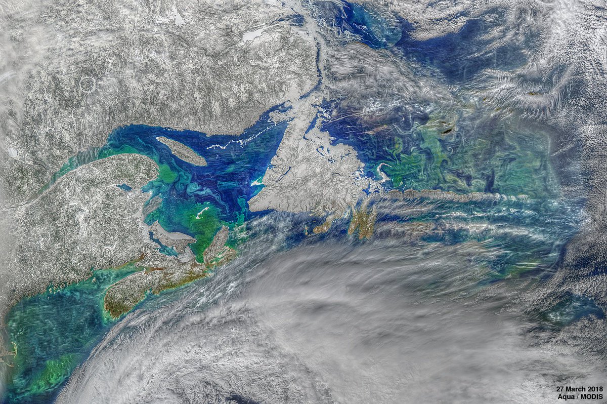
 Spring has sprung in the North Atlantic Ocean!
This vibrant phytoplankton bloom was captured through cloudy skies by Aqua/MODIS on March 27th. (NASA)

The team’s finding opens the door to a host of interesting questions, Dewar adds.
Ocean mixing is an important part of the global climate cycle: It churns up nutrients that feed phytoplankton blooms and aids the exchange of gases with the atmosphere.
Adding biologically driven mixing to physical processes in the ocean makes the equation even more complex, he says.

The next step will be to try to observe the effect at sea, using shipboard measurements, Dabiri says.
“Previous studies looked for turbulence or eddies on the scale of the animals’ size,” he says, instead of large downward jets.
“This paper tells us for the first time what to look for.”

Links :

Wednesday, April 18, 2018

Secrets of the sea bed: Hunt for Stone Age site in North Sea

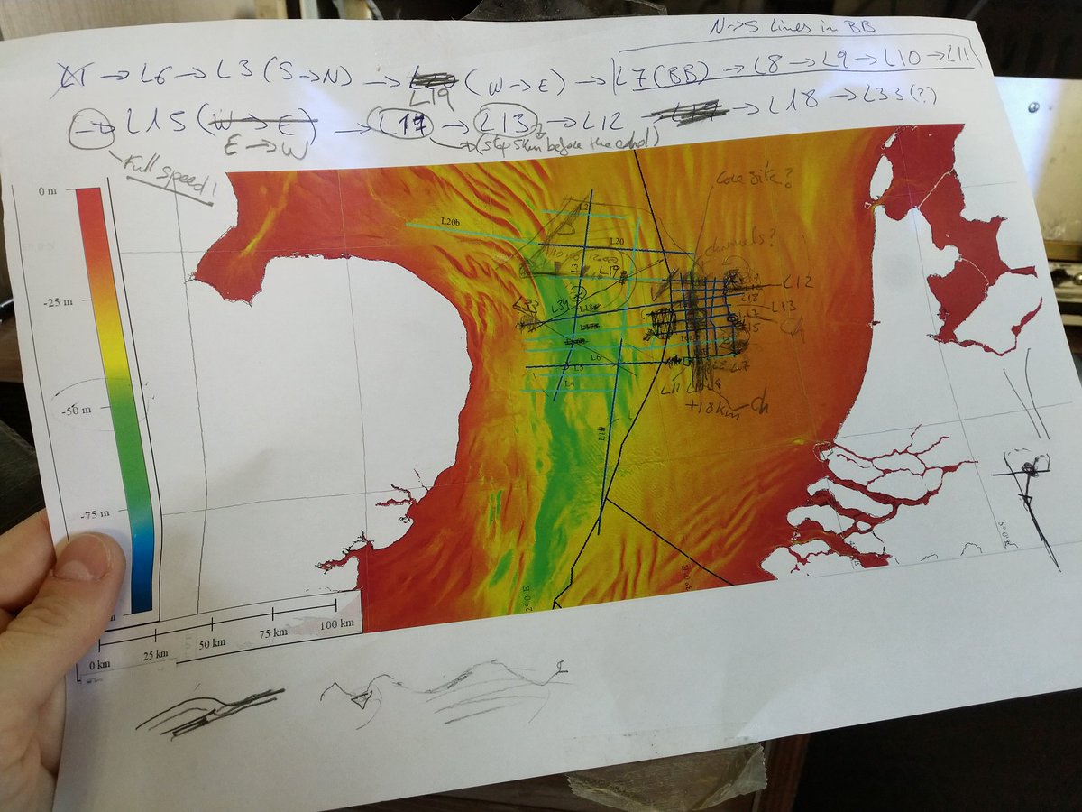
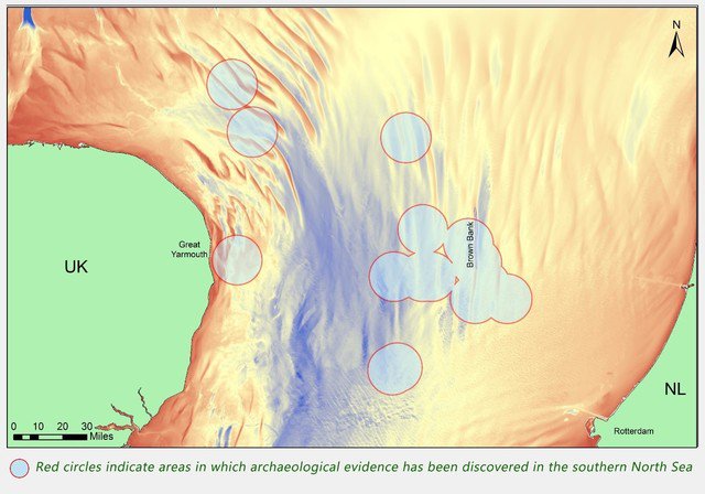
This is the survey plan.
The colored area is bathymetric data of the sea floor.
(twitter.com/BrownBank2018)
From BBC by Laurence Peter

British and Belgian scientists are exploring the sea bed off Norfolk hoping to find evidence that Stone Age people lived there when it was still dry land.
In recent years, some trawler crews and researchers have found prehistoric animal bones and basic stone tools in North Sea sediment.

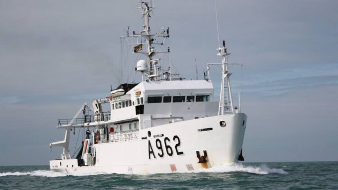
 The RV Belgica: Exploring new frontiers under the North Sea

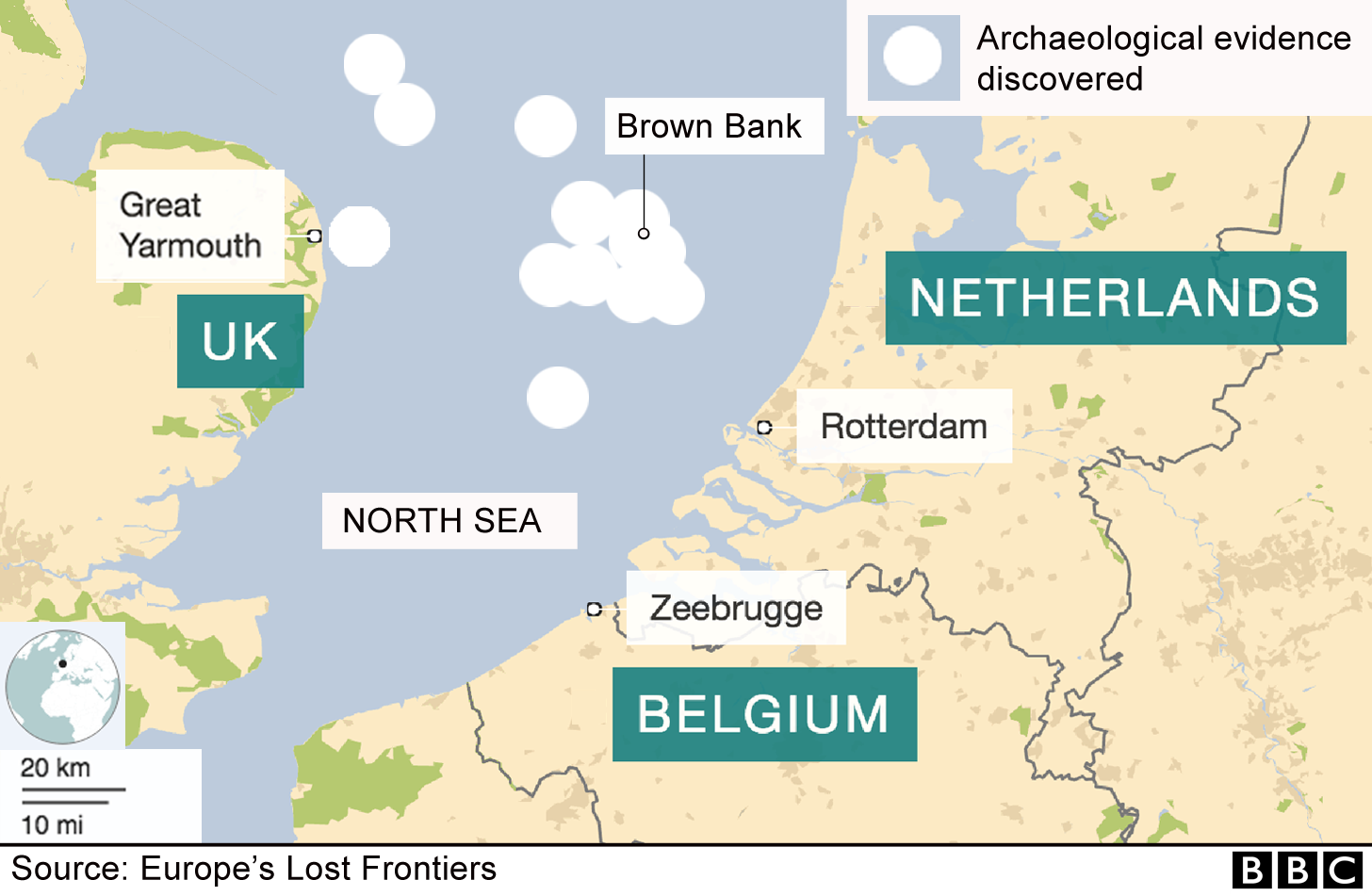
The team on the Belgian ship RV Belgica aims to map the Brown Bank area, a sand ridge about 30km (19 miles) long.
Mesolithic people are thought to have lived there in about 10,000-5,000BC.
"We suspect that the bank is on the edge of a large prehistoric lake, where you would expect settlements," said Prof Vince Gaffney, an archaeologist at the University of Bradford.
Despite the prehistoric finds from the North Sea bed, so far no Mesolithic settlement has been found in that vast area, which flooded after 6,000BC as the Ice Age glaciers retreated.
Eventually the British Isles were cut off from the continent.

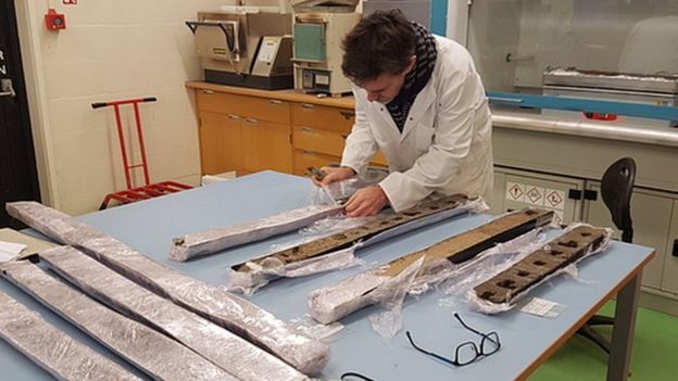
Sediment cores are collected in the quest for signs of Stone Age life 

 When the coast of continental Europe reached as far north as Norway, at the end of the Ice Age, the sea level was about 120m (394ft) lower than today.
"Areas under the North Sea now would have been the best to live in during the Mesolithic [period] - prime real estate, because the coastlines then had fish, birds, fresh water. But it is terra incognita," Prof Gaffney said.
Brown Bank is about 100km (62 miles) from the Norfolk coast.
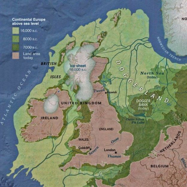
It used to form part of a vast plain known as Doggerland.


For much of the Stone Age, before the Neolithic period, humans were nomadic hunter-gatherers.
But a Mesolithic settlement was discovered at Howick village, near the Northumberland coast - evidence that as long ago as 10,000BC some communities in Britain were no longer nomadic.

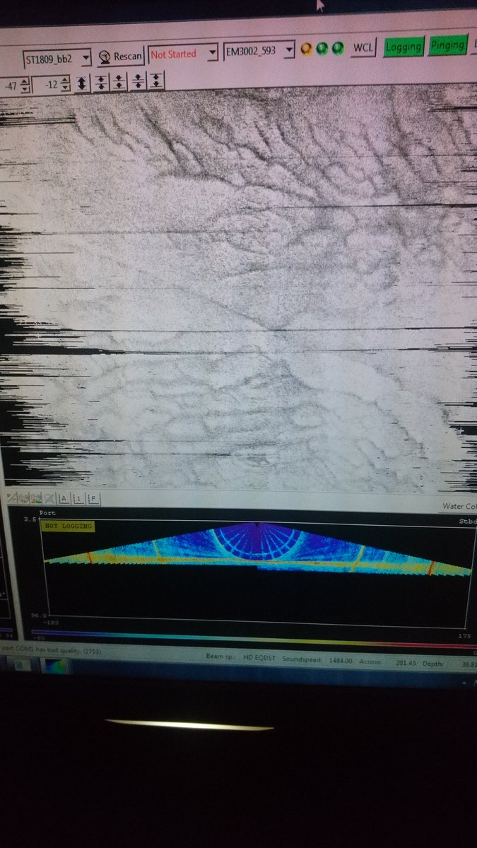
EM3002 multibeam sonar revealing a strange world of sand structures beneath

Bradford archaeologists working with Prof Gaffney are aboard the oceanographic Belgian navy vessel with geologists from Belgium's Ghent University and the Flanders Marine Institute.

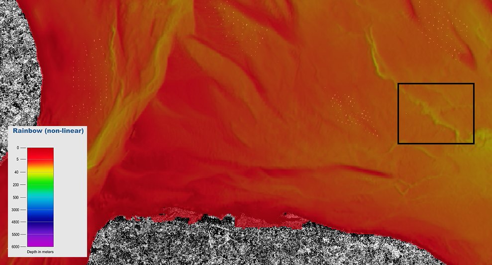
#Sentinel1 view palaeo-channel survey target off East Anglia coast.
(S1 data shown on top of @EMODnet bathymetric data)

 East Anglia with the GeoGarage platform (with chart derivated from UKHO material)
See all the wind farms when on station (Dudgeon Offshore Wind Farm)

Scientists have already mapped more than 45,000sq km (17,375sq miles) of prehistoric landscape under the North Sea, an area larger than the Netherlands, Prof Gaffney said.
But Brown Bank awaits detailed mapping, and then sediment core sampling, to look for DNA and other evidence of prehistoric life.
"The area is so large that complete cultures could be out there," said Prof Gaffney, whose research project is called Lost Frontiers.

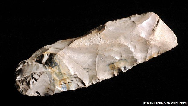
This was identified as a Mesolithic axe, found in the North Sea by a Dutch fisherman in 1988 
 
Ghent University geologist Dr David Garcia Moreno said the Belgica team could collect seabed samples and video sites of interest, but the goal at this stage was to understand the underwater topography in detail.
They will use sonar and seismic equipment for that.
"We want to understand the evolution of rivers that traversed the southern North Sea.
"We think there was a Palaeolithic lake and a large river system all the way from north-west Germany south through Brown Bank to the Dover Strait," he said.

A map showing land around Britain and how it has been lost to the sea over the millennia
 
The research project, funded by the EU's European Research Council, is growing.
It still has at least two years to run.
The Belgica is quite cheap to hire and they are already looking forward to their next expedition, Dr Garcia said.
But Doggerland is not the only undersea territory yet to be mapped and explored for prehistoric remains.
Prof Gaffney says the Bering Strait, off Alaska, and Indonesia's Sunda Strait are bigger.
Who knows what prehistoric secrets lie there?

Links :

Tuesday, April 17, 2018

The shipping industry sets sail toward a carbon-free future

Restricting CO2 emissions: New IMO plan sets global standards.
(Image: Roberto Venturini)

From Grist / Wired by Maria Galluci

Cargo-shipping regulators have struck a historic deal to set their dirty fuel-burning industry on a low-carbon course.

On Friday, the International Maritime Organization agreed for the first time to limit greenhouse gas emissions from global shipping.
The nonbinding deal marks a critical shift for the sector — which, until last week, was the only major industry without a comprehensive climate plan.


From 2030, each individual vessel must reduce its emissions with 40 percent irrespective the development of world trade.
The conclusions are apparent from this photo of the end document.

Cargo ships are the linchpin of our modern global economy, transporting roughly 90 percent of everything we buy.
They also contribute significantly to planet-warming gases in the atmosphere.
If the shipping industry was a country, its total annual emissions would rank in the top 10, between those of Japan and Germany.

Left unchecked, shipping-related emissions are on track to soar by as much as 250 percent by 2050 as global trade expands, the maritime body projects.
Such a spike at sea would offset progress in carbon reduction made on land.

Yet with the new emissions targets, observers say, the shipping industry now has more than a fighting chance to clean up its act.

Without further action, ship emissions around Europe could exceed the total of EU land-based emissions by 2020, according to current trends

A difficult negotiation

The International Maritime Organization agreed to reduce emissions from global shipping by at least 50 percent from 2008 levels by 2050.
The United Nations body also pledged to pursue deeper cuts to meet the Paris Agreement’s more ambitious goal of limiting global warming to 1.5 degrees Celsius, or 2.7 degrees Fahrenheit, above pre-industrial levels.

The hard-won plan follows tense negotiations involving envoys from 173 countries at the organization’s headquarters on the banks of the Thames River in London.
The Marshall Islands and other Pacific nations doggedly pushed the most ambitious proposal on the table: a 100-percent reduction in shipping emissions within two decades, a move that would bring the sector in line with the 1.5-degree target.
The European Union also championed a plan to curb emissions by 70 to 100 percent by mid-century.

Yet other powerful voices in the room, led by Japan, favored smaller emissions cuts and much longer timelines.
The United States and Saudi Arabia, two oil-producing giants, objected outright to any emissions cap.
Meanwhile, some shipping executives warned of rising cargo costs and threats to business if aggressive targets were put in place.

“It was extremely difficult,” says Faig Abbasov, a shipping policy expert with Transport & Environment, a nonprofit advocacy group based in Brussels, Belgium.
“Almost every day, we were coming back to negotiations in the morning thinking, ‘Will it collapse today, or do we have a chance?’”

Environmental groups and industry leaders alike applauded the resulting compromise, saying it will help accelerate the shift away from high-carbon bunker fuel — the sludgy leftovers from the petroleum-refining process — toward cleaner alternatives, such as fuel cells, batteries, and sustainable biofuels.

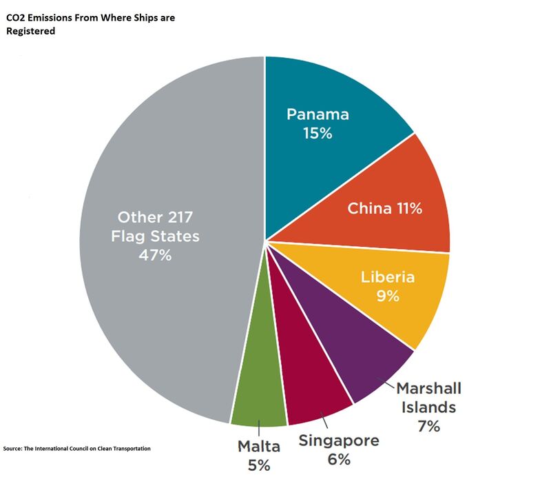
Average share of CO2 emissions by flag state, 2013-2015

The Marshall Islands marshal a deal

Back in 2015, The Marshall Islands was the first country to urge the International Maritime Organization to adopt a greenhouse gas strategy.
It has spearheaded the charge for ambitious shipping rules ever since.

The sprawling Pacific island chain has unique authority on the matter, its officials say, because its livelihood is uniquely intertwined with the shipping industry.

The country is home to the world’s second-largest ship registry, behind Panama, with nearly 12 percent of all cargo ships flying the Marshallese flag.
And its 75,000 people depend on cargo ships to supply nearly all of their food.
Yet greenhouse-gas emissions from shipping and other industries threaten the nation’s very survival, with rising sea levels, extreme storms, and severe drought pushing islanders from their homes.

At the shipping confab, David Paul, the Marshall Islands’ environment minister, argued the final outcome could mean the difference between a “secure and prosperous life” and an “uncertain future” for children born today on the country’s low-lying coral atolls.

After the deal was struck, Paul returned to his central London hotel room overcome with relief, if not exhaustion.
“Just the fact that we were able to get a deal is historic,” he tells Grist. “We’re optimistic that at least there is a way forward.”

Still, he calls the deal the “bare minimum” of what his country could accept as climate policy.
In comparing the organization’s process to a game of baseball, he says last week’s deal is just a single. Effectively, the shipping industry is only on first base enroute to full decarbonization of the sector.
“We realized going into these negotiations that we weren’t going to come away with a home run,” he says. “It’s going to be an incremental process going forward.”

Only the beginning

Last week’s agreement is an initial strategy, with a long-term plan to be adopted in 2023 — after the organization collects emissions data from cargo ships over the period between 2019 and 2021.

In the meantime, regulators are expected to debate binding, enforceable steps that compel — not merely encourage — the industry to reduce its greenhouse gas emissions and a shift away from fossil fuels.

“What was adopted was just IMO’s long-term objective,” Abbasov of Transport & Environment says. “What will actually reduce emissions are the concrete actions. But that’s still to come.”

No specific proposals are on the table just yet, he explains, however, short-term rules will likely target emissions from existing ship operations to keep them from rising any further.
That might mean requiring crews to take steps like lowering their vessel’s operating speeds, which reduces power demand and fuel consumption — but would impact shipping time.

Mid-term measures could compel shipping companies to replace carbon-intensive fuels with cleaner alternatives, including fuel cells powered by hydrogen or ammonia — or for smaller vessels, batteries that can recharge at ports.
Taking these innovations mainstream, however, would likely require adopting “market-based measures,” such as a tax on carbon emissions.

According to a report by the International Transport Forum, an intergovernmental think tank, “Maximum deployment of currently known technologies could make it possible to reach almost complete decarbonization of maritime shipping by 2035.”

Dozens of small ships around the world are now running on hydrogen and electricity, and a major ferry line in Scandinavia is building two of the largest battery-powered ships to date.
Energy-efficient ship designs, smarter logistics systems, and “wind-assisted” technologies, such as spinning rotor sails, are also proven ways to slash emissions.

Still, many of these technologies remain prohibitively expensive for shipowners or aren’t yet available in sufficient supplies.
If every cargo ship today switched to hydrogen fuel cells, for instance, most vessels wouldn’t have enough hydrogen on board to leave the port.

Experts say the International Maritime Organization deal offers a much-needed push for the shipping industry to begin developing and investing in 21st-century technologies.

In a statement, Peter Hinchliffe, secretary general of the International Chamber of Shipping, the industry’s main trade group, summed up last week’s agreement: “We are confident this will give the shipping industry the clear signal it needs to get on with the job of developing zero CO2 fuels.”

Links :

Monday, April 16, 2018

Norway (NHS) layer update in the GeoGarage platform

135 nautical raster charts updated

Lessons learned after passenger ship hits uncharted rock

L'Austral from Ponant Cie

From Safety4Sea

In January 2017, passengers of the cruise ship L’Austral had spent the morning in small boats observing shoreline wildlife on the Snares Islands south of New Zealand.
While the master focused on recovering the boats, the ship inadvertently entered the 300-metre unauthorised zone, which the ship was not permitted to enter and struck an uncharted rock.
The hull was pierced and an empty void space was flooded.

The NZ Transport Accident Investigation Commission (TAIC) issued an investigation report

The rock with which L’Austral made contact was uncharted,
having not been detected during a hydrographic survey of the islands in 1999.

The incident

The French-registered passenger vessel 'L’Austral' arrived off the Snares Islands early on the morning of 9 January 2017.
The passengers spent the morning making shoreline excursions in rigid-hulled inflatable boats, observing the wildlife.
That afternoon the weather became unsuitable for small-boat excursions, so L’Austral rendezvoused with the boats in the sheltered water to the south of the islands to take them back on board.

 GPS position of L’Austral, ship delineation to scale 

While the master was focused on manoeuvring the ship to facilitate the safe recovery of the rigid-hulled inflatable boats, the ship drifted into a 300-metre unauthorized zone, where it contacted an uncharted rock.

Linz NZ 2411 updated raster chart (last ed. February 2018) -see Obstn Rep (2017) addition-
visualization in the GeoGarage platform.
The area where L’Austral struck the submerged rock was surveyed in 1999
to a ±50 m positional accuracy and a ±1.6 m depth accuracy.
Within these parameters it was possible that a rock pinnacle would not have been captured. 
The information captured during this survey was used to produce the paper chart NZ 2411.


A notice to mariners has been published by Land Information New Zealand (Linz) alerting mariners to the existence of an obstruction off Alert Stack, until a full survey can be conducted.
The presumed location of the obstruction off Alert Stack has been added to all paper and electronic charts. 


By the way, Linz has also edited a new ENC after the accident
(NZ 424111 New Zealand - Snares Islands / Tini Heke 25/09/2017 1/22,000)
- Linz had not created any ENC for the area of the Snares Islands at the time of the accident -
NZ424111 viewed in Olex seafloor mapping ECS which nowadays equips the ship (2018)

The rock pierced the hull in an empty void tank, which flooded with water.
The damaged compartment had little effect on the ship’s stability, and the ship was able to continue to another sub-Antarctic island before returning to New Zealand for temporary repairs.
None of the 200 passengers and 156 crew were injured.

Findings


The Transport Accident Investigation Commission found that:
  • The unauthorised zone was a Department of Conservation-controlled zone, where charts indicated dangers unsafe for ships the size of L’Austral.
  • The uncharted rock was in an area that the Commission considers was not suitable for the safe navigation of ships the size of L’Austral.
  • There are deficiencies in the way the crew worked together (bridge resource management), insufficient planning for boat recovery and inadequate monitoring of the ship’s position.
 Extract of paper chart NZ 2411, in use at the time of the accident
Note the area of overfalls, eddies and breakers depicted on the charts for the area south of Alert Stack.
Screenshot from vessel’s ECDIS after the accident.
The vessel’s primary means of navigation was the ECDIS, comprising a primary unit and a back- up planning unit.
The operator’s safety management system referred to French law requiring L’Austral to have a paper chart back-up in addition to the secondary ECDIS unit.
However, the operator had misinterpreted the legislation.
Article 221-V/19 in French law stated that back-up devices for ECDISs could be paper or electronic.
This was not a safety issue as such, as the ship had more than the minimum requirement, that being a primary and a secondary ECDIS, and a folio of paper charts.
(All three systems were up to date). 
Had this area been identified as a no-go area as the chart showed the ‘overfalls, eddies and breakers’ symbol, the ECDIS would have alarmed as the vessel manoeuvred, affording the bridge team time to take avoiding action.

Safety issues
  • Voyage planning and good bridge resource management
  • Unfamiliarity with operation of the ship’s electronic chart display and information system (Sperry VisionMaster FT ECDIS)
  • The Department of Conservation had insufficient maritime expertise applied to assessing risks, given the potentially harsh and sensitive environment in the sub-Antarctic islands and the likelihood that shipping activity will increase in future,

Recommendations

The Commission advised:
  1. That the ship’s operator improve voyage planning, bridge resource management
  2. That the ship’s operator review staff training in correct use of electronic chart display and information systems
  3. That DoC appoint a person to manage safe of navigation in the sub-Antarctic islands.
Photograph showing the CATZOC of the unofficial ENC loaded in L’Austral’s ECDIS.
The ECDIS on board L’Austral was loaded with an unofficial ENC for the Snares Islands,
which had been produced by C-MAP, a Norwegian company.
The C-MAP ENC was derived from published electronic raster navigational charts where the local hydrographic offices had not produced ENCs.
The C-MAP ENC that was in use at the time of the accident is shown in Figure above.
The CATZOC U symbols denote that the “the quality of the bathymetric data has yet to be assessed”.
This low-confidence marker was also used as an indicator that it had not been produced by the local national hydrographic office, in this case LINZ.
The provision of the C-MAP chart portfolio containing unofficial ENCs for loading into L’Austral’s ECDIS should have been accompanied by an alert, warning that some of the charts had not been produced by official hydrographic sources. 
The bridge team on L’Austral did not appreciate that the CATZOC of U shown on their ECDIS at the time of the accident indicated that it had been produced by C-MAP, not by LINZ. 

Lessons learned

The key lessons arising from this inquiry were:
  • An electronic chart display and information system is a valuable aid to navigation.
  • However, mariners need to understand fully and be familiar with all aspects of the system, otherwise relying on the electronic chart display and information system as a primary means of navigation can contribute to, rather than prevent, accidents
    Every part of a ship’s voyage must be planned, and all members of the bridge team must be fully familiar with and agree to the plan.
  • This is a cornerstone of good bridge resource management
    Good bridge resource management relies on a culture where challenge is welcomed and responded to, regardless of rank, personality or nationality.
Links :