
Saturday, April 26, 2025
Friday, April 25, 2025
Dolphins are dying from toxic chemicals banned since the 1980s

A common dolphin stranded on a UK beach
Waves & Wellies Photography
Waves & Wellies Photography
From New Scientist by Melissa Hobson
Polychlorinated biphenyls (PCBs) are commonly found in the bodies of short-beaked common dolphins that get stranded on UK beaches, and are linked to the animals’ risk of infectious diseases
Dolphins in seas around the UK are dying from a combination of increased water temperatures and toxic chemicals that the UK banned in the 1980s.
Polychlorinated biphenyls (PCBs) are a long-lasting type of persistent chemical pollutant, once widely used in industrial manufacturing. They interfere with animals’ reproduction and immune response and cause cancer in humans.
In a new study, researchers showed that higher levels of PCBs in the body and increased sea surface temperatures are linked to a greater mortality risk from infectious diseases for short-beaked common dolphins (Delphinus delphis), a first for marine mammals.
The ocean is facing “a triple planetary crisis” – climate change, pollution and biodiversity loss – but we often look at threats in isolation, says Rosie Williams at Zoological Society of London.
Williams and her colleagues analysed post-mortem data from 836 common dolphins stranded in the UK between 1990 and 2020 to assess the impact of these interlinked threats.
They found a rise of 1 milligram of PCBs per kilogram of blubber was linked with a 1.6 per cent increase in the chance of infectious diseases – such as gastritis, enteritis, bacterial infection, encephalitis and pneumonia – becoming fatal. Every 1°C rise in sea surface temperature corresponded to a 14 per cent increase in mortality risk.
According to the study, the threshold where PCB blubber concentrations have a significant effect on a dolphin’s risk of disease is 22 mg/kg, but the average concentration in samples was higher, at 32.15 mg/kg.
Because dolphins are long-lived, widely distributed around the UK and high in the food chain, they are a good indicator species to show how threats might also affect other animals.
“Their position at the top of the food web means that toxins from their prey accumulate in their blubber, providing a concentrated snapshot of chemical pollutants in the ocean – though unfortunately at the expense of their health,” says Thea Taylor, managing director of Sussex Dolphin Project.

Despite being banned in the UK in 1981 and internationally in 2001, PCBs are still washing into the ocean. “They are still probably entering the environment through stockpiles and are often a side product or a byproduct of other manufacturing processes,” says Williams.
Cleaning up PCBs is very difficult. “Because they’re so persistent, they’re a nightmare to get rid of,” she says. “There is definitely not an easy fix.”
Some researchers are exploring dredging as a cleanup technique, while others are focused on improving water treatment plants’ effectiveness in removing persistent chemicals.
These findings indicate what might happen if action isn’t taken to ban perfluoroalkyl and polyfluoroalkyl substances (PFAS), another widespread group of so-called forever chemicals.
“While we cannot reverse the contamination that has already occurred, it is critical to prevent further chemical inputs into the environment,” says Taylor.
Links :
- Communications Biology DOI: 10.1038/s42003-025-07858-7
- Gizmodo : Wild Dolphins Test Positive for Fentanyl, Suggesting Drugs Are Flooding the Ocean
- New Scientist : Why chemical pollution is turning into a third great planetary crisis / Thousands
of synthetic substances have leaked into ecosystems everywhere, and we
are only just beginning to realise the devastating consequences
Thursday, April 24, 2025
Maritime Spatial Planning : Opportunity for Greek-Turkish dialogue or starting point for new tensions?

Greece’s recent maritime spatial planning, finalized on April 16, 2025, aligns with international law, particularly UNCLOS and EU obligations.
It includes EEZ agreements with Italy and Egypt and uses the median line for non-delimited areas, consistent with legal norms.
Turkey, not a UNCLOS signatory, disputes Greece’s plan but lacks formal MSP or international court backing.
While tensions persist, Greece’s compliance with binding frameworks suggests its approach is legally correct.
The dispute remains complex, with ongoing diplomatic challenges.
source : Grok X
For the first time, Greece officially records its furthest claims over maritime zones based on the Law of the Sea.
This document, along with
the accompanying map, now carries a European stamp.
Its implementation
will be tested on the ground.
A significant initiative by Greece to approve and submit its Maritime Spatial Plan (MSP) to the EU sets in motion the final charting, via maps, of the differing positions of Greece and Turkey on the delimitation of their maritime zones.
Turkey is reportedly preparing to respond with its own map, which will reflect its known pursuits and claims to date.
Turkey’s map showcases unilateral claims in violation of international law.
The MSP is an important step in exercising Greece’s sovereign rights.
However, it will be judged in practice, once its implementation begins in the field — especially in areas where Greece already holds established rights or seeks to exercise them, but Turkey openly disputes them.
After considerable delays, which even led to a condemnation by the European Court of Justice, the Greek government finally decided to approve the MSP.
Beyond the ECJ’s deadline of April 27, there was a serious risk that, following the postponement of the Cyprus-Crete cable project, Greece might appear reluctant to assert its sovereign rights or even publicly define its maritime zone boundaries due to fear of Turkey.

Great Sea Interconnector
EuroAsia Interconnector Cable Project Map by E.U. (shown with maritime delimitation borders).
The EuroAsia Interconnector project is a trans-border HVDC subsea cable system to connect the electricity grids of Israel, Cyprus, and Greece with the European system.
EuroAsia Interconnector Cable Project Map by E.U. (shown with maritime delimitation borders).
The EuroAsia Interconnector project is a trans-border HVDC subsea cable system to connect the electricity grids of Israel, Cyprus, and Greece with the European system.
Image courtesy of EuroAsia Interconnector.
A Significant Move
To regard this decision as merely a communication ploy to deflect concerns over the delayed undersea cable project between Crete and Cyprus would be unfair.
This is a vital first step in asserting Greece’s sovereign rights.
For the first time, Greece’s furthest maritime claims are recorded in an official public document, based on the Law of the Sea — now bearing a European endorsement through its submission to the EU.

EEZ 12 nm
The government clarifies from the outset that the MSP does not proclaim an Exclusive Economic Zone (EEZ), nor does it grant sovereignty or sovereign rights.
It reflects the currently existing maritime zones (e.g., EEZ based on agreements with Italy and Egypt), 6-nautical-mile territorial waters (with the reservation for future extension to 12 n.m., as allowed by the Law of the Sea), and the entire potential EEZ as defined by Law 4001/2011.
Under this law, in the absence of a delimitation agreement with neighboring or opposite states, Greece considers the median line, as calculated by Greece, to be the outer limit of its EEZ.
Based on this, Greece has delineated plots south and southwest of Crete, which have even been granted to foreign companies for hydrocarbon exploration.
Missing Maritime Extension?
There are, however, questions about the absence of the potential 12-n.m. territorial waters in the map — as had appeared in the unofficial working map published by the European Commission, which triggered intense reactions from Turkey.
Since blocking Greece from expanding its territorial waters to 12 n.m. is a central Turkish goal, depicting the current 6 n.m. likely served as a calming gesture.
The map also reflects Greece’s concessions in the EEZ agreement with Egypt — deemed necessary at the time as a formal response to the Turkey-Libya memorandum.

Greece (HNHS) ENC nautical charts coverage

see Google Earth kmz GeoGarage file
Turkey’s Response
Turkey’s official response was couched in diplomatic terms, stating that Greece’s unilateral actions and claims violate Turkish maritime jurisdiction in the Aegean and Eastern Mediterranean, and “have no legal consequence for Turkey.”
Turkey’s official response was couched in diplomatic terms, stating that Greece’s unilateral actions and claims violate Turkish maritime jurisdiction in the Aegean and Eastern Mediterranean, and “have no legal consequence for Turkey.”
Turkey warned it would submit its own MSP to UNESCO and relevant UN bodies, presenting itself as moderate.
It emphasized that issues should be resolved via international law, equality, and good neighborliness — referring to the Athens Declaration.
Clearly, with two conflicting and overlapping MSPs in the Aegean and Eastern Mediterranean, their credibility and viability will ultimately be tested on the ground.
The MSP itself does not automatically authorize specific activities, but provides the broader legal and regulatory framework.
While Turkey’s current reaction is diplomatic, when it comes to implementing actual projects, each country will need to defend the sovereign rights asserted via their respective MSPs.
Cable Projects and Sea Parks
Among the MSP’s regulated activities is the placement of pipelines and cables, keeping the Cyprus–Crete power link a hot issue and a point of friction.
Foreign Minister Giorgos Gerapetritis referred again to “appropriate timing” due to the complexity of the project but insisted all projects will proceed.
Still, postponement of field exploration cannot continue indefinitely — and will serve as one of the first real-world tests of the MSP.
Another challenge will be the creation of Marine Parks in the Aegean — a move the Greek government promised to complete by the end of 2024, despite strong Turkish opposition, especially as they include activities on islets Turkey considers “gray zones.”
By adhering to the Law of the Sea and benefiting from EU legal backing, Greece’s MSP carries more international legitimacy than the Turkish version — which is based on legal gymnastics and lacks global recognition, even if Turkey files it unilaterally with UNESCO, as suggested by Turkish media.
Greek Diplomacy and Future Challenges
In a TV interview, Foreign Minister Gerapetritis suggested that the MSP makes it clear that any opposition should be addressed through dialogue and international legal mechanisms — including potentially a joint application to the Hague Court.
However, these maps, even with the Turkish version pending, will not alter the known differences in Greek-Turkish relations.
Turkey is pushing for comprehensive bilateral negotiations that include all its unilateral claims, starting with talks.

According to customary international law, which is also codified in the UN Convention on the Law of the Sea (UNCLOS), Greece has the right to extend its territorial waters and national airspace to 12 nautical miles.
see MSP Greece
For Athens, formally stating its claims over the potential continental shelf was a prerequisite for taking further steps — including submitting these coordinates to the UN, and advancing actions like closing bays and drawing baselines for calculations.
There’s also the plan for gradual extension of territorial waters to 12 n.m. south of Crete, as previously announced.
There’s also the plan for gradual extension of territorial waters to 12 n.m. south of Crete, as previously announced.
Political Sensitivities
This was a bold and difficult step for the government.
Adoption of the MSP map may falsely imply — to the public as well — that these maritime zones are already secured, which is inaccurate.
This was a bold and difficult step for the government.
Adoption of the MSP map may falsely imply — to the public as well — that these maritime zones are already secured, which is inaccurate.

"National Maritime Spatial Plan" in Mediterranean was accepted by Greek Cypriot Administration of Southern Cyprus.
Turkish MFA made a statement regarding "Maritime Site Planning" approved by Greek Cypriot of Southern Cyprus noted that this unilateral approach will not be accepted
see CSIS map
Zones like the EEZ must be declared and, more importantly, delimited — either through bilateral agreements or adjudication at The Hague.
The issue of granting full effect to Kastellorizo, which provides Greece a maritime link to Cyprus and blocks Turkey’s intended maritime border with Egypt, will be decided either through agreement or The Hague.
But due to the principle of proportionality, Greece’s chances are not strong.
This creates additional political pressure and responsibility for any future government negotiating with Turkey — not just regarding Kastellorizo, but all disputed maritime zones around Greek islands.
Ankara’s Preparation
Turkey was aware of the Greek MSP approval in advance, thanks to ECJ deadlines.
Turkey was aware of the Greek MSP approval in advance, thanks to ECJ deadlines.

draft Turkish MSP and map
Just before Greece’s announcement, Turkish paper Milliyetleaked a draft Turkish MSP and map — not an official document, but a study from Ankara University’s National Center for Maritime Law Research (DEHUKAM).
The institute clarified it’s an academic study and not the official position of the Turkish Republic.
Only the Presidency can issue the official MSP.
However, Turkey’s quick use of the map indicates that this study may form the basis for its forthcoming official MSP, likely to be fast-tracked as a response to Greece.

The Turkish study follows Ankara’s maximalist claims: drawing the median line between mainland coasts and ignoring Greek islands, shifting the line to the middle of the Aegean.
It fully embraces Turkey’s unilateral submission to the UN (March 18, 2020 — A/74/757), the “Blue Homeland” doctrine, the Turkey-Libya Memorandum, and the illegal EEZ deal with the unrecognized TRNC.
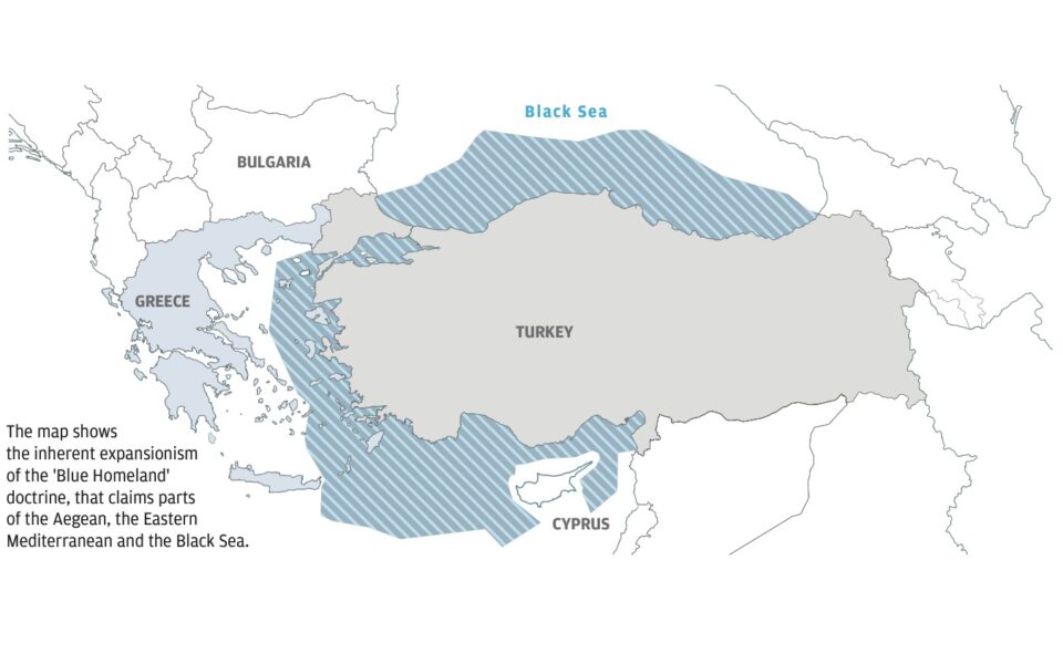
It fully embraces Turkey’s unilateral submission to the UN (March 18, 2020 — A/74/757), the “Blue Homeland” doctrine, the Turkey-Libya Memorandum, and the illegal EEZ deal with the unrecognized TRNC.
Blue Homeland 462,000 km2
It also refers to the Bern Protocol — considered void by Greece — through which Turkey insists that Greece must refrain from any activity outside its 6 n.m.
territorial waters, even in clearly potential Greek maritime zones.
territorial waters, even in clearly potential Greek maritime zones.
Links :
- Ekathimerini : Behind Turkey’s ‘Blue Homeland’ doctrine / Greece finalizes marine spatial planning, releases official map / Ankara releases draft maritime map as part of MSP push / Turkey finalizes maritime spatial planning reflecting Blue Homeland doctrine, Milliyet reports / Turkish defense ministry critical of Greek maritime spatial plan / Greece declares EEZ in Ionian Sea after unveiling maritime spatial plan
- Millet News : Analysis | Greece's maritime spatial planning map: What does International Law say? / Greece announces maritime spatial plan with potential Aegean implications
- War on the Rocks : Blue Homeland : the heated politics behind Turkey's new maritime strategy
- LinkedIn Pulse : The New Map for Maritime Spatial Planning in Greece and Its Policy Implications
- Seville maritime territory map is illegitimate: Expert
- OEMA : From the “Seville Map” to marine parks – What the announcement of the Maritime Spatial Planning means for Greece
- ResearchGate : Maritime Europe and EU enlargement. A geopolitical perspective
- GeoGarage blog : Where to draw the line in the Eastern Mediterranean / EU faces criticism over Aegean maps, overlooks Türkiye’s rights
Wednesday, April 23, 2025
The destruction of the National Oceanic and Atmospheric Administration
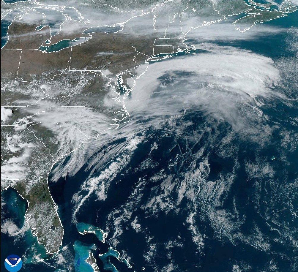
This satellite image from NOAA shows a March megastorm building across the United States,
Thursday, March 13, 2025.
(NOAA via AP)
(NOAA via AP)
From MSN by Gary Giggs, Professor of Earth and Planetary Sciences at UC Santa Cruz
“Move fast and break things” is a catchphrase popularized by Mark Zuckerberg, suggesting that rapid innovation and progress are achieved by embracing experimentation and accepting that mistakes and failures are inevitable.
It essentially advocates for prioritizing speed and disruption over careful planning, with the belief that progress is often made through learning from failures.
While this approach may have benefits in the tech world, it is no way to run a nation, yet, sadly, this is what we are now experiencing in Washington, D.C., with the administration’s plans underway now to essentially destroy the National Oceanic and Atmospheric Administration.
The state of California has jurisdiction over our ocean backyard from the Mean High Tide Line out to three miles offshore; beyond that the federal government takes over.
And while there are multiple federal agencies with some role in those waters, what we know about them and how we use them (including the Fish and Wildlife Service, the U.S. Geological Survey, the Environmental Protection Agency, and the Bureau of Offshore Energy Management, to name a few), I believe that the federal agency with the most involvement in our ocean backyard, is the National Oceanic and Atmospheric Administration, or NOAA.
This agency has many responsibilities that affect us all.
Perhaps the program we benefit from the most is the National Weather Service (NWS), which produces those maps we see in the morning newspaper or on TV in the evening – what we can expect in the hours and days ahead, whether storms, rainfall, snow and alerts about hazardous conditions that we, as well as aircraft and ships, would like to avoid.
NOAA also manages the National Environmental Satellite, Data, and Information Service, which maintains all the satellites that provide the information that the National Weather Service utilizes to produce the images and maps displaying that weather information.
The National Ocean Service (NOS) maintains hundreds of tide gauges along the nation’s coasts with records available on an easy to access website that are used by ships (including the U.S.Navy), fishing boats, ports and harbors, pleasure boaters, surfers, hikers, tide poolers or ocean explorers, in order to know when the low and high tides will be and their elevations, as well as the extreme water levels to be expected during king tides and El Niño events (https://tidesandcurrents.noaa.gov/map/).
All these tide gauges, some of which have now been in operation for over 150 years, are also providing a record of how rapidly sea level is rising at individual sites in coastal states.
NOS also is the agency that develops the nautical charts that boaters and ships around the nation and world use for safe navigation.
The Office of Oceanic and Atmospheric Research (OAR) provides the research that gives us a better understanding of the way our ocean and atmosphere work, how it is changing, and what this means for us.
With the information gathered from the NOAA fleet of ships and planes, this allows meteorologists to produce more accurate weather forecasts and provide earlier warnings for natural disasters such as hurricanes, tornadoes, atmospheric rivers and tsunamis.
The role of this branch is to provide unbiased science to better understand the environment, nationally and globally.
The National Marine Fisheries Service (NMFS) tracks the nation’s fresh and saltwater commercial and recreational fisheries and helps set quotas on what can be harvested each year to maintain a sustainable population of each species.
The NMFS scientists are also responsible for marine mammal protection, whether sea otters, whales, dolphins, seals or sea lions as well as endangered species conservation.
We have a National Marine Fisheries Service Laboratory with a group of scientists here in Santa Cruz at the university’s Coastal Science Campus.
They study groundfish (rockfish and flat fish such as halibut and sole, among others) and anadromous species (fish that migrate between fresh and saltwater) including Coho and Chinook salmon and steelhead.
These scientists focus on causes of variability in abundance and the health of fish populations, and the economics of exploiting and protecting natural resources.
They also assess the stocks of species targeted by various fisheries and assist in evaluating potential impacts of human activities on threatened or endangered species.
Results of this research are used by the Pacific Fishery Management Council to manage fisheries and by NOAA Fisheries to manage threatened and endangered species and their habitats.
The NMFS scientists also support research carried out by UC Santa Cruz scientists and students, a unique opportunity for both groups.
Another important component of NOAA is the National Marine Sanctuaries program, including our Monterey Bay National Marine Sanctuary, which protects over 6,000 square miles of ocean and extends for 276 miles along the state’s coast from the Marin Headlands to Cambria, one of the largest in the national marine sanctuary system.
Through an innovative partnership, the city of Santa Cruz and the National Marine Sanctuary collaborated to build the Exploration Center that complements existing local marine educational facilities such as the Seymour Marine Discovery Center and the Monterey Bay Aquarium.
The national Sea Grant program is also part of NOAA.
It is a federal-university partnership program established by Congress in 1966 that brings science together with communities to create and maintain a healthy coastal environment and economy.
This network consists of partnerships between NOAA and 34 university-based programs in every coastal and Great Lakes state, Puerto Rico and Guam.
This network has used the expertise of over 3,000 scientists, engineers, public outreach specialists, educators and students for nearly 60 years to help us better understand, conserve and utilize the nation’s coastal resources.
Despite all that NOAA does for the American public and the oceans, a very recent memo from the White House Office of Management and Budget outlines plans to effectively break up NOAA, cut program budgets, and end its climate work by abolishing its primary research office and forcing the agency to help boost U.S. fossil fuel production – really?
They are going to help the oil companies find and extract more oil and gas?
This is all part of Trump’s broader goals of slashing federal spending, gutting climate research and expanding U.S. energy production.
As it turns out, U.S. oil and gas production is at an all-time high, and with the price of oil and the uncertainty now with tariffs and global economics, the oil companies are very cautious about investing in more drilling, regardless of any presidential ambitions.
NOAA’s office of Oceanic and Atmospheric Research which is responsible for research on the Earth’s oceans, atmosphere, climate and weather patterns, would be eliminated under the proposed plans.
According to a leaked document from the Office of Management and Budget, the Trump administration is planning to end climate research at both the National Oceanic and Atmospheric Administration and the National Aeronautics and Space Administration.
If this goes ahead, it would be an illegal escalation by the Trump administration against the United States’ scientific enterprise and will directly hurt American livelihoods, leading to more deaths and greater economic damage from extreme weather events.
Congress holds the power of the purse in our democracy and should step up to oppose harmful cuts to NOAA and NASA.
While the proposed cuts claim to only be directed at climate change research, which would be disastrous on its own, the scientific institutions on the chopping block are imperative for the prediction and research of extreme weather events, including tornadoes, hurricanes and floods.
The memo proposes closing all 16 Cooperative Research Institutes in 33 states, every one of the 10 research labs, all six regional climate centers, slashing the budget for the NASA Goddard Space Institute, and ending $70 million in grants to research universities.
Thousands of seasoned scientists, early career scientists, and young scientists in graduate schools will lose funding.
These folks have spent their livelihoods conducting research that improves climate and weather prediction that directly affects every American.
Andrew Rosenberg, the former deputy director of NOAA Fisheries under the Obama administration said “It’s devastating. It’s idiotic and abusive.”
The oceans and atmosphere have no political affiliation, they belong to and serve all of us.
What are these people thinking?
Links :
- Common Dreams :
- Trump officials say destroying endangered species’ habitats isn’t ‘harm’ / Trump plan would eliminate NOAA Climate research, slash agency budget
- NYTimes : White House Plan Calls for NOAA Research Programs to Be Dismantled
- PBS : As NOAA shrinks under Trump’s cuts, employees speak out
- CNN : Trump’s budget plan eviscerates weather and climate research, and it could be enacted immediately
- The Guardian : ‘Chaos’: Trump cuts to Noaa disrupt staffing and weather forecasts
- Reuters : How Trump’s regulatory freeze is disrupting the US fishing industry
- Science : Trump seeks to end climate research at premier U.S. climate agency
- EmptyWheel : NOAA the biggest little agency in America
- GeoGarage blog : DOGE’s chaos reaches Antarctica / Elon Musk is coming for our weather service / For-profit companies can’t easily replace NOAA’s weather-forecasting process
Tuesday, April 22, 2025
China mapping seafloor around US allies to send nuclear submarines—analyst

From Newsweek by Ryan Chan
Chinese vessel is suspected of mapping the seafloor around U.S. allies Australia and New Zealand to support submarine deployments, an analyst has said.
All observed activities conducted by the ship, Tan Suo Yi Hao, "appear to be in accordance with international law," the Australian Defense Department told Newsweek.
Newsweek has contacted the Chinese Foreign Ministry for comment by email.
Why It Matters
The Tan Suo Yi Hao, which means "Discovery One" in English, is operated by the state-run Chinese Academy of Sciences' Institute of Deep-Sea Science and Engineering.
The Tan Suo Yi Hao, which means "Discovery One" in English, is operated by the state-run Chinese Academy of Sciences' Institute of Deep-Sea Science and Engineering.
It is built for conducting deep-sea exploration and is the mother ship of two types of submersibles.
China is expanding its military reach and presence within and beyond the western Pacific Ocean with the largest navy in the world by hull count—which has more than 370 vessels, including 12 nuclear-powered submarines, according to the latest Pentagon assessment.
Last summer, three Chinese research vessels were tracked operating in the Indian Ocean for suspected survey missions, which could be used to aid in China's submarine warfare.
Both Australia and New Zealand are part of the Five Eyes, a U.S.-led intelligence alliance.
What To Know
The Tan Suo Yi Hao was underway in the southeastern portion of the Indian Ocean off the west coast of Australia as of Tuesday, Ray Powell, the director of the Stanford University-affiliated SeaLight maritime analysis organization, wrote on X, formerly Twitter.
A Newsweek map shows the Chinese ship was outside the Australian 200-nautical-mile (230-mile) exclusive economic zone (EEZ).
It previously transited the Great Australian Bight off Australia's southern coastline and the country's EEZ after leaving New Zealand.
The Chinese vessel did not take the "most direct" route back to China, where it is expected to arrive on April 30, Powell said, adding that the "dual-purpose" ship, which is reportedly capable of gathering intelligence, has another objective: surveying the Diamantina Trench.
According to Powell, the Tan Suo Yi Hao paused its voyage twice over the trench, which has a depth of 8,047 meters (26,401 feet).
The analyst said this could indicate the deployment of submersibles, which can reach 10,000 meters below sea level, according to its operator.
The "most obvious" reason for China to carry out deep-sea research off Australia and New Zealand would be to facilitate its submarine force deployments, including submarines that are armed with nuclear missiles, at "strategic deep-sea locations," the analyst concluded.
Prior to its voyage near Australia, the Chinese vessel conducted a joint research expedition from January to March with scientists from New Zealand at the Puysegur Trench's deepest point, located 6,208 meters below sea level and to the southwest of New Zealand.
In a statement to Newsweek, a spokesperson for the Australian Defense Department said the "Chinese government-owned" Tan Suo Yi Hao was approximately 737 nautical miles west-southwest of Perth, the capital city of Western Australia, as of Tuesday.
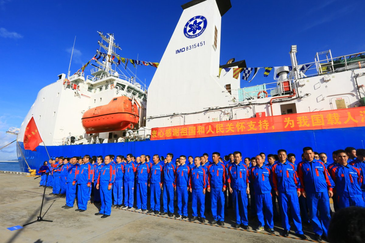 Chinese deep-sea science and engineering research vessel Tan Suo Yi Hao returning to port after completing deep-sea testing on October 3, 2017, in Sanya, Hainan province, China.
 Sun Qing/Getty Images
Australia has not observed the Chinese deep-sea science and engineering research vessel "conducting maritime research or survey activities" within its EEZ, the statement added.
Marine scientific research within the EEZ waters "shall be conducted with the consent of the coastal state," according to the United Nations Convention on the Law of the Sea.
What People Are Saying
A spokesperson for the Australian Defense Department said: "[The Australian Defense Force] monitored the Tan Suo Yi Hao as it transited to the south of Australia and while it remained in our maritime approaches."
A spokesperson for the Chinese Embassy in Australia said: "Over recent years China has conducted joint scientific expeditions with multiple countries, making positive contribution to global marine biodiversity protection and sustainable development. Politicizing or stigmatizing of the research activities is disrespectful to global scientific development."
Alex Luck, a naval analyst in Australia, wrote on X: "China has had a long-standing program running to reach some of the deepest maritime regions. This has research applications, but also an obvious political and reputational angle as a maritime nation."
What Happens Next
It remains to be seen how long the Tan Suo Yi Hao will stay in the waters off Australia.
Its voyage comes after China sent a flotilla for an unprecedented circumnavigation of Australia and the deployment of an American nuclear-powered submarine to Australia.
Links :
Links :
Monday, April 21, 2025
Phantom islands
Phantom Islands are artifacts of the age of maritime discovery and colonial expansion.
During centuries of ocean exploration these islands were sighted, charted, described and even explored – but their existence has never been ultimately verified.
Poised somewhere between cartographical fact and maritime fiction, they haunted seafarers’ maps for hundreds of years, inspiring legends, fantasies, and counterfactual histories.
Phantom Islands – A Sonic Atlas interprets and presents these imaginations in the form of an interactive map which charts the sounds of a number of historical phantom islands.
Sunday, April 20, 2025
What the hell is going in Antarctica


Coronation island (UKHO)


---


Trump islands (UKHO)
Links :
- NASA: Ice lost, island found ?
Subscribe to:
Posts (Atom)