Saturday, January 10, 2015

The coast


Borderlands. The bridge between two worlds.
Where the known meets mystery.
Powerful, unforgiving–and exactly what Hayden Peters was looking for.
Trading the city for the daily sting of salt water on his skin, Hayden reveals how life on the coast brings him balance like no other place on earth could.

Friday, January 9, 2015

The largest vessel the world has ever seen


It’s been a year of remarkable global achievements for Shell’s Prelude project.
From the installation of the first processing module in South Korea to the construction of the largest turret ever built in Dubai.
Take a look at some of the extraordinary highlights from this world first project to liquefy natural gas at sea.


From BBC by David Shukman
Climbing onto the largest vessel the world has ever seen brings you into a realm where everything is on a bewilderingly vast scale and ambition knows no bounds.
Prelude is a staggering 488m long and the best way to grasp what this means is by comparison with something more familiar.
Four football pitches placed end-to-end would not quite match this vessel's length - and if you could lay the 301m of the Eiffel Tower alongside it, or the 443m of the Empire State Building, they wouldn't do so either.
In terms of sheer volume, Prelude is mind-boggling too: if you took six of the world's largest aircraft carriers, and measured the total amount of water they displaced, that would just about be the same as with this one gigantic vessel.
Under construction for the energy giant Shell, the dimensions of the platform are striking in their own right - but also as evidence of the sheer determination of the oil and gas industry to open up new sources of fuel.

 Modules weighing 5,500 tonnes are lifted onto the vessel by huge cranes

Painted a brilliant red, Prelude looms over the Samsung Heavy Industries shipyard on Geoje Island in South Korea, its sides towering like cliffs, the workforce ant-like in comparison.
Soon after dawn, groups of workers - electricians, scaffolders, welders - gather for exercises and team-building before entering lifts that carry them the equivalent of ten storeys up.
On board Prelude, amid a forest of cranes and pipes, it is almost impossible to get your bearings. Standing near the bow and looking back, the accommodation block that rises from the stern can just be made out in the distance.
The yard, one of the largest in the world, is a mesmerising sight with around 30,000 workers toiling on the usually unseen infrastructure of the global supply of fossil fuels: dozens of drilling ships, oil storage tankers and gas transporters.

Park and produce

Prelude is not only the largest of all of these to take shape in this hive of activity - it also pioneers a new way of getting gas from beneath the ocean floor to the consumers willing to pay for it.
Until now, gas collected from offshore wells has had to be piped to land to be processed and then liquefied ready for export.
Usually, this means building a huge facility onshore which can purify the gas and then chill it so that it becomes a liquid - what's known as liquefied natural gas or LNG - making it 600 times smaller in volume and therefore far easier to transport by ship.
And LNG is in hot demand - especially in Asia, with China and Japan among the energy-hungry markets.
To exploit the Prelude gas field more than 100 miles off the northwest coast of Australia, Shell has opted to bypass the step of bringing the gas ashore, instead developing a system which will do the job of liquefaction at sea.
Hence Prelude will become the world's first floating LNG plant - or FLNG in the terminology of the industry.
In Shell's view, this means avoiding the costly tasks of building a pipeline to the Australian coast and of constructing an LNG facility that might face a long series of planning battles, and require a host of new infrastructure on a remote coastline.
So Prelude will be parked above the gas field for a projected 25 years and become not merely a rig, harvesting the gas from down below, but also a factory and store where tankers can pull alongside to load up with LNG.
The computer animations make it look easy. In practice, the engineering challenge is immense. To speed up construction, the key elements of the processing system are being assembled on land before being installed on the vessel.
During our visit, we witnessed the extraordinary sight of a 5,500-tonne module being winched into position on the deck. Like a massive jigsaw piece, it was a tight fit - given that Shell is planning to squeeze the LNG plant into one quarter of the space you would expect on land.
This was the third of 14 modules.
The installation took less than a day and was successfully completed but there's clearly a lot of work still to do, which is why Shell officials are coy about committing to a date for when Prelude will actually start work. It looks like being several years at least.


Cris Moreno has a big job on his hands.
His task is to make sure Shell's Prelude FLNG project can transfer its liquid cargo in one of the loneliest places on the planet; 200km's off the north-west coast of Australia.
It took thousands of hours to develop the technology needed to deliver the challenge, but Cris is finally ready to test these 'arms of innovation' for the first time.

Bridge too far?

The Shell pitch is that gas, as the cleanest of the fossil fuels, is set to become more important in the coming decades as a far more climate-friendly alternative to coal.
And as China tries to clean up its polluted air, largely caused by coal-burning power stations, as I reported in January, switching to gas would surely make a difference.
Only up to a point, however: the gas-is-cleaner argument only works if the new supplies of gas actually replace coal rather than become an additional source of fuel.
And the UN's Intergovernmental Panel on Climate Change concludes that while gas would be a welcome "bridge" between coal and low-carbon energy for the next 20 years or so, in the long term it will need to be phased out, like all fossil fuels, unless a way is found to capture the carbon dioxide that burning it releases.
Shell is banking on gas being in such demand that prices will remain high enough to justify Prelude's cost - which has not been stated but must run into billions.
Obviously there are risks.
The gas price might collapse, if China's economy dips, or Japan restarts its nuclear power stations, closed since the Fukushima disaster, and suddenly needs less gas.
Shell's ambition is to launch a fleet of future Preludes to pioneer a new chapter in the story of fossil fuels by opening gas fields previously thought to be too tricky or expensive to tackle.
As our lift brings us back down to the quayside, the winter sun bathes the dockyard in golden light and convoys of buses ferry the multitude of workers home.
During the night, specialist teams will check for the strength of the welds and the quality of the work. A project of this kind has never been tried before and, like all firsts, Prelude is something of a gamble.

Links :
  • GeoGarage blog : The gas platform that will be the world's biggest 'ship'

Thursday, January 8, 2015

H-Note mobile app from UKHO enables mariners to submit hydrographic data


An ADMIRALTY H-Note App is now available for Android™ devices and iPhone, iPad and iPod touch.
This App is aimed at mariners wishing to send hydrographic data to the UKHO via a mobile device.


The ADMIRALTY H-Note App presents a quick and simple new way to report new or suspected dangers to navigation or changes observed in aids to navigation.

The application takes advantage of the mobile device's built-in camera and GPS to help gather important navigational information and to e-mail it to the UKHO using the device's e-mail software once the vessel is in a WiFi or cellular coverage area.


When you submit an H-Note via the App, you will receive an acknowledgement and the information will be used by the UKHO to take immediate action or to consider using the information in the next appropriate revision of a chart or publication.


The H-Note App is available for both Android devices and iPhone, iPad and iPod touch.
It can be downloaded on Google Play and on the App Store:

        Get it on Google Play


Mariners are asked to report information affecting ADMIRALTY Charts and Publications, issues with ENCs and any other any other suspected dangers to navigation direct to the UKHO using the H-Note App which:
  • provides a simple form to enter details,
  • can automatically include your current location coordinates (via the GPS in your device),
  • captures images from your built-in camera,
  • loads previously taken photos stored on your device,
  • submits the H-Note direct to the UKHO using your device’s email programme,
  • keeps a record of all your H-Notes.
Hugh Phillips, Head of Product Management at the UKHO commented:
“The ADMIRALTY H-Note App is a more efficient way for mariners to continue sharing any information with us that could be navigationally significant. Every mariner and every ship, whether sailing internationally or in local waters, has a part to play by serving as our eyes across the oceans.”

Please visit the UKHO website for more information on H-Notes and Maritime Safety.

Finding floating forests: it takes an online village to map massive kelp

Landsat 8 Natural Color
Landsat 8 Near-infrared
Natural color (top) and near-infrared (bottom) images from Landsat 8 show the kelp-rich waters around California’s Channel Islands.
Clouds, sunglint, and sea foam make it difficult for computer programs to detect the location of forests.
So far, human eyes work better.
(NASA Earth Observatory image by Mike Taylor and Jesse Allen, using Landsat data from the U.S. Geological Survey)

From NASA  by Laura Rocchio Design by Paul Przyborski & Mike Carlowicz 

If you have ever walked along the California coast, you’ve likely had to navigate around clumps of seaweed. Fathom this: before it was thrown up by the surf and left to dry on the beach, that seeming jetsam was part of a majestic underwater forest just offshore.

Kelp on a California Beach
Strong waves, often fueled by winter storms, can remove large patches of offshore kelp and deposit them on the beaches of California.
(Photo courtesy of Chad King / NOAA MBNMS)

Giant kelp forests are among Earth’s most productive habitats, and their great diversity of plant and animal species supports many fisheries around the world.
The kelp, or Macrocystis, that make up these underwater forests truly are giant.
They are the world’s largest marine plants and regularly grow up to 35 meters (115 feet) tall; the largest giant kelp on record stood 65 meters (215 feet) tall.
Divers have compared swimming through mature kelp forests to walking through redwood forests.
Unlike redwoods, giant kelp are ephemeral.
They live for seven years at most, and often they disappear before that because of winter storms or over-grazing by other species.
As fishermen know, giant kelp forests can appear and disappear from season to season, from year to year. But is there a long-term trend or cycle at work?

A few years ago, Jarrett Byrnes was in a bit of a quandary over these disappearing forests.
As part of his postdoctoral research at the University of California–Santa Barbara (UCSB), he was studying giant kelp at four National Science Foundation-funded sites off the coast.
Since 2000, biologists had been using this Long-Term Ecological Research (LTER) site to make monthly in situ measurements of giant kelp. But Byrnes and his colleagues found that they often could not make measurements in winter because rough seas made the diving unsafe.

Kelp underwater
Kelp are the redwoods of the sea.
The world’s largest marine plants regularly grow up to 35 meters (115 feet) tall.
(Photograph © Phillip Colla / Oceanlight.com)

“Storms remove quite a bit of the canopy in the winter. Sometimes they even remove whole forests if the storms are large enough,” Byrnes explained.
“But getting to those sites with regularity in the winter gets very challenging.”
Most of the diving had to wait until summer, and by then the kelp had largely recovered or changed, making it difficult to measure how much damage the storms had done.
To complicate matters, kelp forests have different seasonality depending on where they are.
For instance, the forests along the Central California coast are at their maximum size in the fall; in Southern California, they often reach their peak in the winter and spring.

How could these dynamic habitats be monitored more frequently without putting divers at risk?
Kyle Cavanaugh, then a UCSB graduate student, had an idea.
“These forests change so rapidly and on a variety of different time scales—months to years to decades—so we needed a long record with consistent, repeated observations,” Cavanaugh said. He devised a method to use Landsat satellite data to monitor kelp forests.
A few things made Landsat an obvious resource. Since the 1970s, the satellites have had a regular collection schedule (twice monthly).
 Their data and images are managed by the U.S. Geological Survey and are reliably stored in an archive that dates back more than forty years.
And Landsat’s images are calibrated, or standardized, across different generations of satellites, making it possible to compare data collected across several decades.

Landsat 8 image of kelp
Landsat 8 can detect near-infrared wavelengths of light that make it easier to spot offshore kelp forests.
(NASA Earth Observatory image by Mike Taylor, using Landsat data from the U.S. Geological Survey)

Landsat measures the energy reflected and emitted from Earth at many different wavelengths.
By knowing how features on Earth reflect or absorb energy at certain wavelengths, scientists can map and measure changes to the surface.
The most important feature for the kelp researchers is Landsat’s near-infrared band, which measures wavelengths of light that are just outside our visual range.
Healthy vegetation strongly reflects near-infrared energy, so this band is often used in plant studies.
Also, water absorbs a lot of near-infrared energy and reflects little, making the band particularly good for mapping boundaries between land and water.
“The near-infrared is key for identifying kelp from surrounding water,” Cavanaugh explained.
“Like other types of photosynthesizing vegetation, giant kelp have high reflectance in the near infrared. This makes the kelp canopy really stand out from the surrounding water.”
For Byrnes, the approach was a breakthrough: “This meant we could see the forests I was analyzing right after storms hit them.”

Growing Fast and Holding Fast

Giant kelp are fast growers, and they thrive in cold, nutrient-dense waters, particularly where there is a rocky and shallow seafloor (5 to 30 meters or 15 to 100 feet).
They attach to the seafloor with small root-like structures (haptera) also called, appropriately enough, a holdfast.
The holdfast supports a stipe, or stalk, and leaf-like blades that float thanks to air-filled pockets (pneumatocysts).
The fronds create dense floating canopies on the water surface, yet these massive plants rely on holdfasts barely 60 centimeters (24 inches) wide to keep them rooted and alive.

Given the right balance of conditions, giant kelp can grow as much as 50 centimeters (1.6 feet) per day, and this robust growth makes it possible for kelp fronds to be commercially harvested.
Giant kelp have been plucked from California waters since the early 1900s, and they have long appeared in products like ice cream and toothpaste.
At the industry’s peak, large ships using lawnmower-like machinery could harvest more than 200,000 wet tons annually.

Floating kelp canopies
Kelp fronds create dense floating canopies near the water surface.
Kelp have been harvested for a century for commercial products; they also pose trouble for boat propellers.
(Photo courtesy of Chad King / NOAA MBNMS)

“The satellite could definitely see the effects of harvesting, but the kelp recovery was very fast,” said Tom Bell, a UCSB researcher and collaborator with Byrnes and Cavanaugh.
Today, only a few thousand tons of giant kelp are harvested each year, some by hand and some by mechanical harvesters.
The kelp can be trimmed no lower than 4 feet below the water surface, and this sustainable harvesting is the equivalent of humans getting a haircut.
Studies have shown that negative affects are negligible, although some fish populations are temporarily displaced.

California coast
Giant kelp thrive in cold, nutrient-dense waters, particularly where there is a rocky, shallow seafloor. The California coast provides ideal habitat.
(NASA Earth Observatory image by Mike Taylor, using Landsat data from the U.S. Geological Survey)

For years, scientists debated whether it was nutrient availability or grazers (not human harvesters, but sea urchins) that had the most influence over kelp forest health, size, and longevity.
After using Landsat to look at long-term trends, and comparing those trends to known differences between Central and Southern California waters, Cavanaugh and LTER lead Daniel Reed found that a third force—wave disturbance—was the kingmaker of kelp dynamics.
Strong waves generated by storms uproot the kelp from their holdfasts and can devastate the forests far more than any grazer.

Kelp research branches out

When giant kelp first brought Byrnes and Cavanaugh together at UCSB, their work was largely California-focused.
The data they collected from the LTER study sites off Santa Barbara became a tremendous resource for kelp researchers.
But that work covered four discrete locations for a species found all over the world.
Giant kelp can grow anywhere there are cold, shallow, nutrient-rich waters and a rocky seafloor. Conditions for kelp growth have historically been ideal along the west coast of North America, as well as Chile, Peru, the Falkland Islands, South Africa, and around Australia, New Zealand, and the sub-Antarctic islands.
More and more often these days, though, the conditions are less ideal.
Climate change has brought a trifecta of kelp scourges: warmer waters with fewer nutrients; new invasive species; and severe storms.

Underwater kelp
Given the right balance of conditions, giant kelp can grow as much as 50 centimeters (1.6 feet) per day.
(Photograph © Phillip Colla / Oceanlight.com)

After a recent meeting on kelp forests and climate change, Byrnes, Cavanaugh, and other colleagues set out to consolidate all of the available kelp forest data from around the world.
They wanted to take a step toward understanding how climate change is affecting kelp globally, but they quickly discovered they had a sparse patchwork of information.
Byrnes was struck with a thought.
They had used Landsat to expand their studies across time, so why not use Landsat to expand their studies around the world?
Could Landsat be used to establish global trends in kelp forest extent?
The answer was yes, but the problem was eyeballs.
Unlike research on terrestrial vegetation—which uses Landsat data and powerful computer processing arrays to make worldwide calculations—distinguishing kelp forests requires manual interpretation.
While kelp forests pop out to the human eye in near-infrared imagery, computers looking at the data numerically can confuse kelp patches with land vegetation.
Programs and coded logic that separate aquatic vegetation from land vegetation can be confounded by things like clouds, sunglint, and sea foam.

“I’ve spent many, many years staring at satellite imagery trying to come up with new ways to extract the kelp signal from that imagery, and it is very time and work intensive,” said Cavanaugh, now based at the University of California–Los Angeles.
“But automated classification methods just don’t produce acceptable levels of accuracy yet.”
Byrnes, now based at the University of Massachusetts–Boston, realized that the best way to study global kelp changes was to turn to citizen scientists.
Byrnes and Cavanaugh put together a science team and joined with Zooniverse, a group that connects professional scientists with citizen scientists in order to help analyze large amounts of data.
The result was the Floating Forests project.

Getting help from a few thousand friends

The Floating Forest concept is all about getting more eyeballs on Landsat imagery.
Citizen scientists—recruited via the Internet—are instructed in how to hunt for giant kelp in satellite imagery.
They are then given Landsat images and asked to outline any giant kelp patches that they find.
Their findings are crosschecked with those from other citizen scientists and then passed to the science team for verification.
The size and location of these forests are catalogued and used to study global kelp trends.
In addition to examining the California coast, which Byrnes and Cavanaugh know well, the Floating Forests project has also focused on the waters around Tasmania.
Tom Bell and collaborators in Australia and New Zealand have noticed dramatic declines in giant kelp forests there over the past few decades.
The decline has been so rapid and extensive that giant kelp are only found now in isolated patches.

2014 Landsat
1999 Landsat
Off the east coast of Tasmania, 95 percent of the kelp has disappeared since the 1940s.
False-color Landsat images from September 1999 (top) and September 2014 (bottom) provide evidence of recent kelp forest disturbance.
(NASA Earth Observatory image by Mike Taylor, using Landsat data from the U.S. Geological Survey)

Off Tasmania’s east coast, 95 percent of the kelp has disappeared since the 1940s.
The loss has been so stark that the Australian government listed Tasmania’s giant kelp forests as an “endangered ecological community“— the first time the country has given protection to an entire ecological community.
The loss is so stunning because this was a place where kelp forests were once so dense that they merited mention on nautical charts.

Cool, subarctic waters once bathed Tasmania’s east coast, but warmer waters (as much as 2.5ºC (4.3ºF) warmer) have brought many invasive species that feast on giant kelp.
Compounding the matter, the overfishing of rock lobsters has removed a key predator of the long-spined sea urchins (which eat kelp).
The ecosystem’s new protected status could help curb overfishing and restore the lobsters, which would help diminish the threat from sea urchins.

This U.S. Hydrographic Service chart from 1925
This U.S. Hydrographic Service chart from 1925 shows Prosser Bay, Tasmania, and the distribution of giant kelp.

Using Landsat to monitor the kelp forests and establish trends may shed more light on what is happening off of Tasmania.
“We believe the data from Floating Forests will allow us to better understand the causes of these declines,” said Cavanaugh.
As of November 2014, more than 2,700 citizen scientists had joined Byrnes and Cavanaugh to look for kelp in 260,000 Landsat images.
All combined, the citizen scientists have now made more than one million kelp classifications.
The response has exceeded expectations, and the project has been expanded faster than originally planned.
Already a discovery has been made.
A citizen scientist found a large patch of giant kelp on the Cortez Bank, an underwater seamount about 160 kilometers (100 miles) off the coast of San Diego.
While giant kelp on this submerged island—which comes within feet of the surface at some points—had been documented by divers and fishermen in the past, the full extent of the kelp beds was unknown.

Outlying kelp forest
A citizen scientist found satellite evidence of an outlying kelp forest that was previously known only to divers and local fishermen.
(NASA Earth Observatory image by Mike Taylor, using Landsat data from the U.S. Geological Survey)

“The first few months of Floating Forests have been a huge success, and we are hopeful that we will soon be able to expand the project to other regions,” Cavanaugh said.
“Our ultimate goal is to cover all the coastlines of the world that support giant kelp forests.”
To learn how to participate in the Floating Forests project, visit their web page.

Links :

Wednesday, January 7, 2015

SpaceX to try ocean platform landing of Falcon rocket

The rocket should eventually land on this 300 by 100 foot (91 by 30 meter) platform,
which SpaceX calls an "autonomous spaceport drone ship"
(AFP Photo/Handout)

From AFP by Kerry Sheridan

SpaceX scrubs rocket launch yesterday: it must wait until Friday to try again 

SpaceX aims to propel modern rocket science into a brave new era Tuesday by landing a key part of its Falcon 9 rocket on a floating platform in the Atlantic Ocean.

Billionaire Internet entrepreneur Elon Musk, who heads the California-based company, said on Reddit late Monday he has "no idea" if the attempt will work, after previously giving the bid a 50-50 chance of success.
"I pretty much made that up. I have no idea :)" he wrote in an "Ask Me Anything" session.

The experiment involves the first-ever attempt at guiding the powerful first stage of the rocket to landing spot about 200 miles (322 kilometers) off the coast of northern Florida after launching from Cape Canaveral at 6:20 am (1120 GMT).


SpaceX hopes the effort will transform the rocket industry from one that creates parts worth millions of dollars that are left to fall into the ocean after blastoff, to one that reuses its assets much the way commercial airlines fly the same planes again and again.
"A fully and rapidly reusable rocket -- which has never been done before -- is the pivotal breakthrough needed to substantially reduce the cost of space access," said a company statement.


- Guided rocket return -

The attempt will come after the Falcon 9 launches from NASA pad early Tuesday, carrying the unmanned Dragon cargo vessel which is packed with supplies and equipment for the six astronauts living at the International Space Station.
The rocket will separate, as it usually does, allowing the second stage to continue propelling the spaceship to orbit.
But this time, SpaceX will relight the engines on the 14-story tall Falcon 9 first stage.
Then, three separate engine burns should guide and slow the rocket down so it can land upright on the 300 by 100 foot (91 by 30 meter) platform, which SpaceX is calling an "autonomous spaceport drone ship."

Extra fins have been added to the rocket to help it maneuver.
"The grid fins are super important for landing with precision," Musk wrote on Reddit.
"The aerodynamic forces are way too strong for the nitrogen thrusters. In particular, achieving pitch trim is hopeless. Our atmosphere is like molasses at Mach 4!"

 Video of Falcon 9 Reusable (F9R) during a 1000m test flight at our rocket development facility in McGregor, TX.
This flight was our first test of a set of steerable fins that provide control of the rocket during the fly back portion of return.
The fins deploy approximately a minute and 15 seconds into the flight, and return to their original position just prior to landing.

The company has already shown in two tests that it could execute some control over the return the first stage of the Falcon 9, slowing it down to a hover before allowing it to splash into the ocean.
This time, no personnel will be within a distance of about 10 miles from the landing platform, said Hans Koenigsmann, vice president for Mission Assurance at SpaceX.
He also said that real-time updates are not likely even though there are cameras on the rocket to capture the experimental landing.
"It is very difficult to hit a platform of that size," he said at a NASA briefing on Monday.
"If you look at it from almost 150 miles up in suborbit, it looks like a very small place to land on."
SpaceX had described the challenge as going from a landing accuracy of 10 kilometers in past tests to 10 meters in this attempt.

In the final moments, gravity should help the rocket set itself down on the platform.
"The center of gravity is pretty low for the booster, as all the engines and residual propellant is at the bottom," Musk wrote.

 Following the successful launch of six ORBCOMM satellites, the Falcon 9 rocket’s first stage reentered Earth’s atmosphere and soft landed in the Atlantic Ocean.
This footage is from a chase plane filming the decent of the first stage back to earth.

- Heaviest load yet -

The launch was initially supposed to take place last month. But SpaceX postponed it on December 18 after a launchpad static test fire was a "tad short" and the team decided to exercise caution and postpone until the New Year, Koenigsmann said.
If the company's fifth contracted launch with NASA to the ISS goes ahead as planned Tuesday -- and weather is 70-percent favorable for launch -- the Dragon cargo ship should arrive at the ISS on January 8.

The supply ship is carrying its heaviest load yet -- 1.8 pressurized metric tons of "much-needed cargo," said ISS program manager Mike Suffredini.
"The SpaceX folks have used quite a bit of ingenuity to help us put items in all the little cracks and crevices as we kind of lean on the Dragon vehicle to supply ISS here for the next little while until the Orbital folks are flying again," he told reporters.

SpaceX has a $1.6 billion contract with NASA for 12 missions to supply the space station and return cargo to Earth.
Orbital Sciences also has a $1.9 billion contract with NASA to supply the space station.
However, an engine failure on Orbital's Antares rocket in October cost the company $200 million in lost parts and postponed its remaining launches until further notice.

Tuesday, January 6, 2015

The U.S. Navy's next super weapon? here come unmanned underwater vehicles

"When battle looms, UUVs could push the fleet's defensive frontier outward, holding surface and subsurface threats at bay while working with other sensors to apprise commanders of what's transpiring in their environs."

From TheNationalInterest by James Holmes

What's an unmanned underwater vehicle (UUV) good for?
A lot—if the technology fulfills its hype.
In that sense the UUV inhabits the same limbo as shipboard unmanned aerial vehicles (UAVs).
UAVs have proved they can operate from aircraft-carrier flight decks, but the U.S. Navy appears conflicted about whether they should be mainly surveillance or mainly strike aircraft.
UAVs clearly have a place in the carrier air wing, but time, technological progress, and cost will determine what it is. In turn tactics, operations, and strategy must obey the limits of the possible.

 Navy Launches Remote Control Surveillance
Mini Submarine - Unmanned Underwater Vehicle in Bahrain

A fair amount of ink has been spilled over the years elucidating the technical dimensions of UUV projects.
Rather than retread old ground, let's situate UUVs in their operational and strategic context.
If things do work out, remote-controlled or autonomous UUVs could amplify the U.S. Navy's effectiveness throughout the slate of missions entrusted to that fighting force.
Surface vessels could deploy UUVs for reconnaissance or combat duty.
Indeed, the U.S. Navy's littoral combat ships rely on embarked helicopters and UUVs for anti-submarine and counter-mine missions.
Attack submarines, moreover, can carry UUVs sized for launch through their torpedo tubes.
Larger, more capable vehicles boasting their own armament are also in the works as an adjunct to the silent service.

To glimpse the import of this newfangled gadgetry, look at the map.
To police the maritime commons, in peacetime and wartime alike, a navy needs sufficient assets and firepower on station at the right places and times.
A regional power—even a China or India—has the luxury of concentrating its resources in discrete parts of the commons.
Beijing cares mainly about the China seas, New Delhi mainly about the Indian Ocean.
That simplifies problems for Chinese and Indian seafarers.

Littoral seabed landing submarine combat simulation
 DCNS - SMX-26 

But if you're the U.S. Navy and your operating theater is the world, police or warfighting duty demands not just serious combat capability but ships and aircraft in large numbers.
When budgets are fixed, shipbuilding costs are spiraling upward, and fleet totals are stagnant, commanders and their political masters naturally cast about for lower-cost substitutes for pricey hulls and airframes.
It's an open question whether the navy can afford the modest boost in fleet totals the sea-service leadership envisions.
For instance, the attack-submarine inventory may fall to as few as 41 boats over the coming years as the navy strains to fund replacements for its aging Ohio-class ballistic-missile subs.
Fewer SSNs, less geographic coverage.
Hence service chieftains' search for UUVs and carrier-borne UAVs.

Geography, then, stands aback of the mania for new undersea capabilities.
But it's not just the sheer volume of water to be overseen, is it?
It's also about working within the fixed setting imposed by nautical terrain.
Where can mariners find enemies plying the waves, or otherwise monitor and regulate the flow of shipping?
No navy, no matter how well equipped with gee-whiz hardware, is all-seeing.
Now as throughout history, the best places to find a ship are at its port of origin, at its destination, if known, or at focal points such as straits where shipping must converge to pass from point A to point B.

 Ryukyu islands chain with the Marine GeoGraage (NGA charts)

In Northeast Asia, for instance, passages piercing the Ryukyus island chain funnel east-west passage between the East China Sea and Western Pacific into narrow pathways.
Such pathways are easily monitored—and perhaps interdicted—relative to seeking out adversaries on the open ocean.
The Malay Peninsula and Indonesian archipelago, similarly, corral shipping transiting between the South China Sea and the vast Indian Ocean into cramped shipping lanes.

Stationing UUVs at such geographic nodes would amplify the American presence, improving watchfulness for a fleet too small to be everywhere all the time. Such sentinels—especially if technology permits arming them for distant operations—will bolster the prospects for success in such missions as fleet actions, sea denial, blockades, and otherwise controlling major sea routes.
A century ago historian Sir Julian S. Corbett catalogued the basic functions navies perform.
For Corbett a navy exists to dispute a stronger opponent's command of the sea, wrest away command for itself, and exploit command once it's in hand.
That's not a bad way to project the contributions UUVs could make, and to measure success as they join the fleet.

 An interesting documentary on US navy nuclear armed submarines
produced by the pentagon channel. 

For instance, submarines remain the sea-denial platform par excellence.
They can penetrate and wreak havoc in enemy-dominated waters while the U.S. and allied surface fleets try to assemble combat power sufficient to win command.
UUVs can act as the eyes of the undersea fleet and, over time, could extend attack boats' combat reach beyond the very modest range of their torpedoes.
When battle looms, UUVs could push the fleet's defensive frontier outward, holding surface and subsurface threats at bay while working with other sensors to apprise commanders of what's transpiring in their environs.
Acting as a fleet skirmisher, safeguarding the underwater flank, and helping complete the operational picture is no small accomplishment.

And once the American and allied navies gain control of contested waters, UUVs will still have their part to play.
Winning command of the sea confers the prerogative to control shipping, blockade enemy shores, land troops, and on and on.
Littoral combat ships, for example, would likely be assigned to deploy their UUVs to clear minefields before amphibious transports moved inshore to land marines or soldiers.
Keeping watch over nautical focal points would help the navy enforce maritime quarantines while preventing an enemy from mounting new high-seas threats.
UUVs, in short, could become the new workhorses of the fleet.

So my metrics for judging the progress of UUV operations will be technical adequacy and Sir Julian's geographically informed guide to maritime strategy.
Are unmanned underwater vehicles a cure-all for everything that ails a cash-strapped navy?
Doubtful.
But their potential is worth tapping to the max.

Links :
  • GeoGarage blog : Navy develops ‘GhostSwimmer’ drone that looks like a shark


Monday, January 5, 2015

Why we still don't have the technology to find missing airplanes

 A map with the mark "TKP" (C), believed to indicate the possible location of the wreckage of
AirAsia flight QZ8501, is seen onboard SAR ship Purworejo on Jan. 1, 2015. (Reuters)

From TheDailyDot by S.E. Smith

In an era where it’s possible to track a stolen Macbook Pro at the click of a button, it seems ludicrous to imagine an entire airplane disappearing.
Yet, that’s exactly what happened this year, twice, when Malaysia Airlines Flight 370 mysteriously vanished in March, followed by a similar disappearing act on the part of AirAsia QZ8501 on last Sunday 2014.


And, thanks to the outdated technology we use to track aircraft, it’s an event that could happen again. The next time you’re on a flight over the ocean, look down.
There’s a high probability that nobody knows where you are.

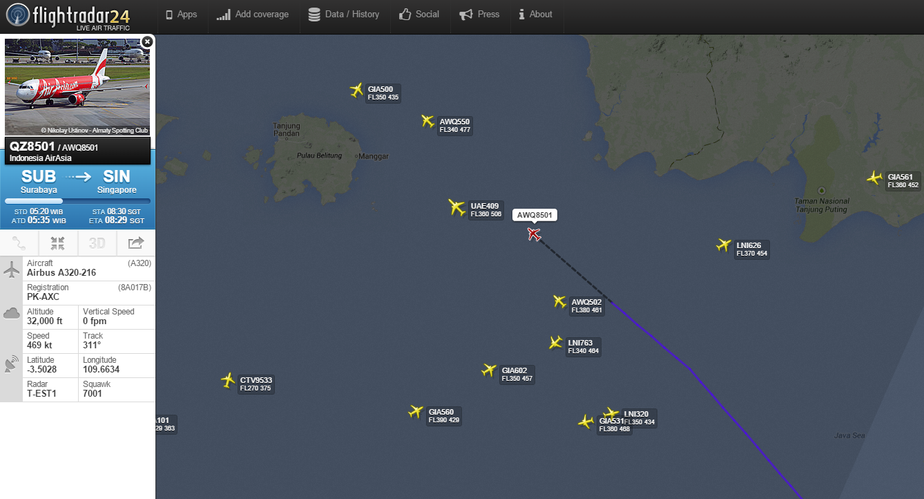
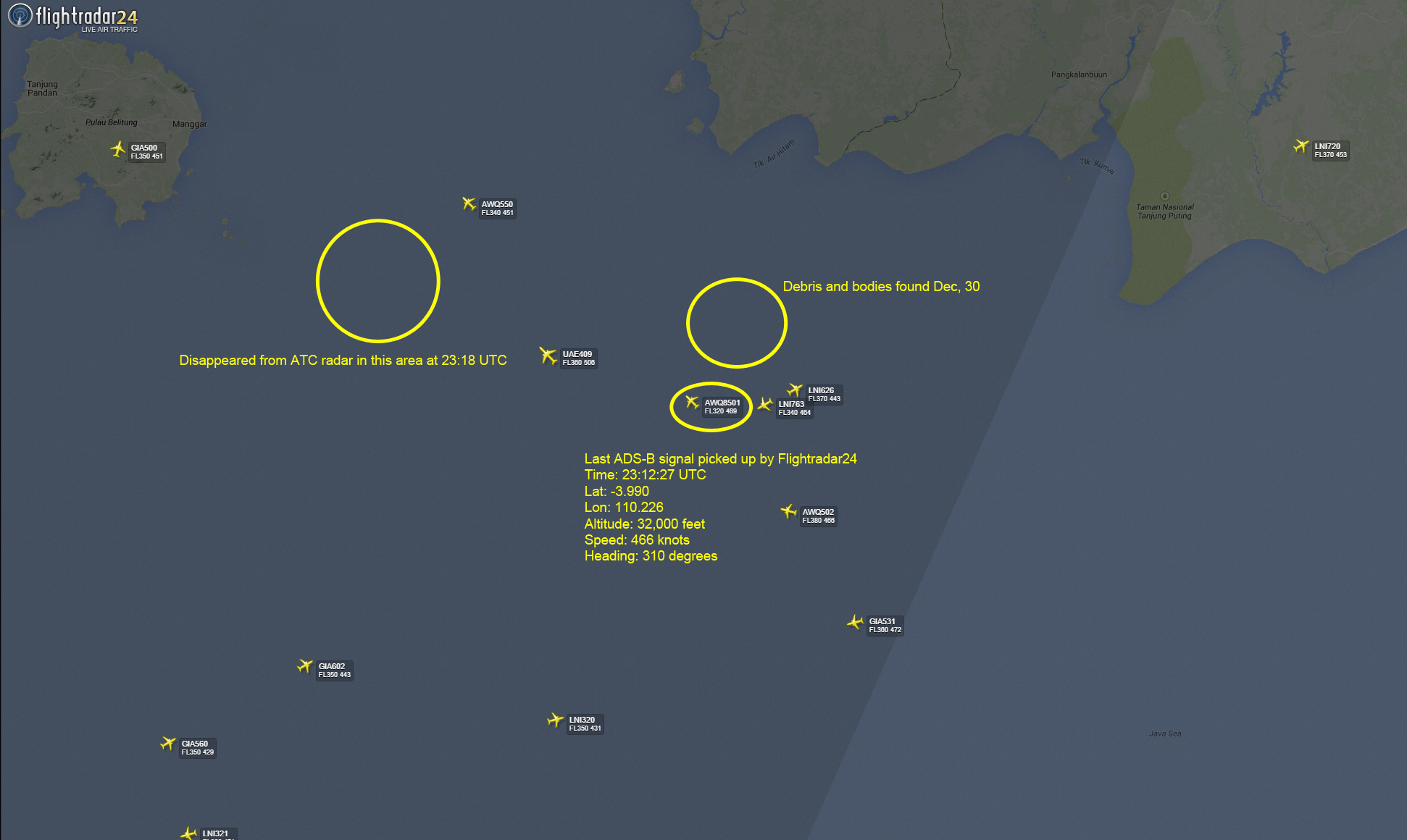
Graphics showing last location of #QZ8501 on Flightradar24
and location where debris and bodies have been found

If that concerns you, it should, but it doesn’t seem to bother any of the regulatory agencies responsible for the safety of the over three billion passengers who board airliners every year.
Nor does it upset airlines.
Despite the fact that some of the technology used for tracking and monitoring planes dates to the 1930s, regulators and airlines have been slow to adopt alternative technologies, even though they’re available.
In 2015, we may be doomed to repeat the problems of 2014, unless we rethink the way we monitor air traffic over the world’s oceans.

You might think that airline tracking relies on a highly sophisticated series of satellites and GPS, but you’re actually wrong.
Planes are tracked via radar, an old but still highly effective method of keeping track of large objects in the sky, but it has some flaws, even with the use of a combination of both primary and secondary radar systems.
Air traffic control towers and military installations start by using primary radar, which detects objects in range by reading reflected radio signals, to track the movement of aircraft: Think of the classic cockpit green screen with approaching fighter jets in an action movie.

 South West on Borneo with the Marine GeoGarage (NGA charts)

Primary radar works whether pilots want it to or not: It’s based entirely on an external radar installation.
Unless the radar is turned off, it’ll continue to function, although poor weather can cause problems, and eventually, the curvature of the Earth makes it impossible to pick up signals (a radar installation at San Francisco International, for example, can’t detect a plane taking off from Tokyo Narita).

Secondary radar requires interaction with a transponder in an aircraft, which can be deactivated by pilots if they want to remain undetected, as, for example, if a plane is hijacked.
The transponder contains details about the plane, the flight, and other useful data for air traffic control to help them track the movements of specific flights and plan runway allocations, clearances, and other business accordingly.
(At major hubs like O’Hare, as one might imagine, transponder data is critical to prevent potentially horrific accidents.)

At about 150 miles out to sea, civilian radar on shore can’t pick up planes anymore.
They’re only visible on ship-mounted radar, which is entirely dependent on where ships happen to be at any given point in time, and such radar installations are primarily used by the military.
If a satellite happens to be passing overhead and snapping photos at the right moment, it can provide a clue, but satellites don’t simultaneously cover the entire globe, even if NSA spying sometimes make this seem like a distinct possibility.
If pilots run into trouble when they’re over the ocean, they can only call home via high frequency radio.


 Underwater search area with dimension of 57x10 nautical miles established.
Five ships are tasked, says Malaysia's chief of navy.
Photo: @ChiefofNavy/Twitter 

Many aircraft vehicles are actually equipped with GPS to help pilots (like Google Maps, for airliners), but that data is not sent to air traffic control.
It's possible to uplink and transmit that data, but the cost would be extremely high.
Planes may periodically ping satellites to determine their positions, but these contacts are few and far between, which is how a plane can go missing with scant information about where it went.

Theoretically, a new navigation system called Automatic Dependent Surveillance Broadcast (ADS-B) will help replace radar as the primary tracking and navigation tool for aircraft.
It uses interactions with other aircraft, ground installations, and satellites to provide more information about aircraft and flight paths, but it, like radar, is far less effective over the ocean, unless airlines want to use expensive satellite uplinks.

Another possible tool is Aircraft Communications Addressing and Reporting System (ACARS), an innovative system used by many airlines to collect in-flight data about their planes.
The system was primarily designed to streamline service and maintenance, collecting information that could be used to determine when and how planes need to be serviced.
The system can also communicate with the ground about critical fixes that need to be addressed, allowing technicians to be waiting on the runway with supplies to reduce the turnaround time at airports. ACARS was actually instrumental in locating Air France 447, lost in the Atlantic in 2009, and even with the technology, it took two years to find the black boxes.

The system, designed primarily as an efficiency tool, is found on approximately 90 percent of U.S. planes, but the same does not hold true around the world.
Early reporting suggests the aircraft was equipped with ACARS, although AirAsia Indonesia had not released the type and scope of data collected by press time.

In the United States, the FAA is in the process of working on a satellite-based tracking and navigation known as Next Gen.
The advanced technology reflects the future of air traffic, but unfortunately, it’s a number of years away, and it’s a voluntary domestic navigation system, not a global one.
For Next Gen to be effective for activities like tracking missing flights over the ocean, it would need to be both global and required for all carriers under international regulations.

Next Gen : an image of a flight plan graph

Meanwhile, “black boxes” (they’re actually bright orange) might seem like a good way to find a plane, but they don’t emit GPS signals.
Instead, they use ultrasound, which can only be picked up in limited depths.
If a plane goes down in deep water, the black boxes are virtually impossible to locate, which makes it difficult to determine what went wrong, and where.
If you think black boxes should be continuously transmitting data throughout a flight, you’re not alone; at the Guardian, Stephen Trimble pointed out that they’re ridiculously outdated, in part because planes have the equivalent of dialup uplink speeds in a time of broadband.

 Tomnod, searching web tool from DigitalGlobe imaging

In this case, the searchers may be fortunate.
The plane was on a flight path in a high-traffic area with much more substantial radar coverage, flying over shallower waters, which will make it easier to locate, and once the remains are located, investigators can start exploring the sequence of events that caused the crash.
Shortly before the plane stopped communicating, the pilot had requested permission to increase altitude because of weather, a marked difference from the Malaysia Airlines flight, where the last contact didn’t indicate that anything was amiss.
So far, the circumstances look much similar to those of a flight that crashed over the summer, when bad weather forced a pilot to request changes to the flight plan, but the plane still went down; even a talented pilot can’t necessarily beat out the elements.

What would be the best way to ensure that all planes, no matter which carrier they flew under, could be located in the wake of disasters?
One option is to require them to carry emergency transmitters, which is already the case in the United States.
As a failsafe, carriers could be required to keep ADS-B and ACARS active at all times; the data they collect can be processed on board to transmit only the most essential information, thereby limiting the amount of bandwidth it takes up.
A better satellite network, like the one already in place to provide Internet and phone connectivity on select flights, could also effectively reverse-engineered to find flights, using tools like phone GPS to determine where a plane was last spotted, so to speak.
Likewise, global adoption of Next Gen could play a key role in offering realtime data about flight paths that could help pinpoint planes in trouble.
Finding the remains of downed airplanes is important for determining what went wrong.
Air travel still remains, statistically, the safest mode of travel, but any plane crash is a crash too many.
Even in the case of airlines and jets with excellent safety records, as was the case here, it’s important to be asking sharp questions about airliner safety, and airlines must cooperate with regulatory authorities to develop effective monitoring technology.

Hand in hand with updates to the tracking systems we use for planes over the ocean, it’s important to also be pushing for better routine fleet maintenance, stricter standards for aircraft inspection and retirement, tighter regulations on working hours for pilots and crew, and other measures that will improve safety.
Perhaps AirAsia QZ8501 was fated to fall out of the sky.
Maybe it was pilot error, like poor judgment in the advance of an oncoming storm.

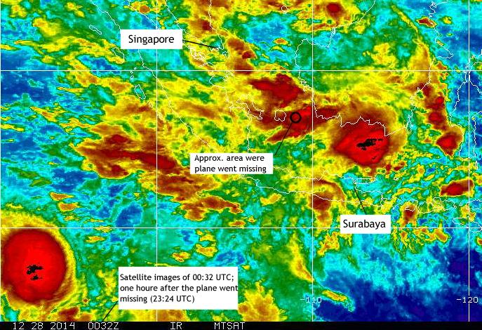
Weather satellite image of the area,
an hour after #QZ8501 went missing over Java Sea.

Or maybe something went terribly wrong, and it could have been prevented.
With growing numbers of passengers lining up for budget airlines, it’s important to find out if corners are being cut to bring costs down.
We may never know what happened to the Malaysia and AirAsia planes, and if that's the case, we need to ask ourselves why.

Links :
  • NYtimes : Where AirAsia Flight 8501 was lost and debris found
  • Bloomberg : Why we still can't track an airplane
  • 9News : Eighty years after Amelia Earhart went missing, how can we still be losing planes?
  • RedOrbit : Does missing AirAsia plane highlight need for improved tracking technology? 
  • Skift : AirAsia black box search renews debate on better airplane tracking
  • BBC : How do you track a plane?

Sunday, January 4, 2015

The essence of sailing


Footage by Team Alvimedica onboard reporter Amory Ross