Age of sail / Theatrical Version from Chromosphere Set on the open ocean in 1900, AGE OF SAIL is the story of William Avery
(Ian McShane), an old sailor adrift and alone in the North Atlantic. When Avery reluctantly rescues a teen (Cathy Ang) who has mysteriously
fallen overboard, Avery finds redemption and hope in his darkest hours.
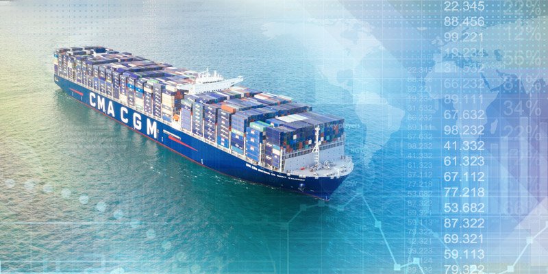
An estimated 90% of world trade is facilitated by maritime shipping, and as trade volumes continue to increase, the world’s busiest ports continue to grow larger and more efficient to meet demand.
In fact, in just the last four years, the median annual volume of the top 50 ports jumped from 5.49 to 5.86 million twenty-foot equivalent units (TEUs).
Here are the world’s 20 largest ports, using the most recent data from the World Shipping Council:
Only five of the top 20 ports in the world are now located outside of East Asia. The Port of Los Angeles is the only U.S. entrant in the top 20, and only three European ports made the cut.
Today, trade is more likely than ever to flow through the South China Sea. Ruling the high seas
From dollar store knick-knacks to nuclear reactor components, China’s manufacturing output is a critical link in the global supply chain.
Getting all those products to consumers and companies around the world is big business, and over the past decade, China has emerged as the heavyweight champion of world shipping.
While Danish company, Maersk, is still the largest shipping line, an ever increasing share of the world’s container traffic is moving through Chinese controlled ports.
An estimated two-thirds of container traffic now passes through Chinese ports or ports that have received Chinese investment.
While shipping volumes on a global basis continue to rise, not all of that growth has been spread around equally. This is particularly true for established titans of the South China Sea.
At the outset of this millennium, Hong Kong and Singapore were home to the busiest ports in the world.
Today, both are facing increased competition from neighboring ports, as well as declining volumes:
In contrast, the massive Port of Shanghai saw a 71% increase over the last decade, and many other Chinese ports has seen significant growth in volume in recent years.
If China’s One Belt One Road initiatives and investments in global port facilities are any indication, the country’s domination of maritime shipping will only continue to strengthen in the near term.
Why this mysterious location blurred out by Google ? This tiny island out in the East Siberian Sea is remote, abominably cold, and for some reason, it's blacked out on Google Earth. It's
hard to even imagine why — although Russia and the U.S. briefly argued
about who owns it, the U.S. hasn't pursued it and recognizes it as
Russian.
If you are browsing around Google Maps and, for some reason, looking at islands in the East Siberian Sea, you will come across something peculiar — a nightmarish black blob covering up what should be a landmass named Jeannette Island.
This island, in reality, is quite small, at only three square kilometers, and part of the De Long Island archipelago in the East Siberian Sea.
The uninhabited island was not discovered until the late 19th century during the Jeannette Expedition, which tried, unsuccessfully, to reach the North Pole through the Bering Strait.
Though the history of Jeannette Island is as brief as it is uninteresting, the peculiar way that Google Maps renders it has led to a plethora of conspiracy theories, ranging from the involvement of aliens to secret deals from President Obama.
Jeannette island in The GeoGarage platform (NGA chart)
Missing and incomplete data on mapping services is not an uncommon occurrence, of course.
In some cases, areas are censored or obscured on satellite imagery intentionally; there is a fascinating Wikipedia article listing a number of locations with intentionally or unintentionally censored or blurred locations.
The reasons for obscuring some of these are self-evident — they’re nuclear power plants, prisons, etc.
— while other decisions to obscure maps are political (all of Israel and Palestine, thanks to U.S. legislation).
There are, hence, a few questions worth asking with regard to Jeannette’s “disappearance”: Was the blacking out of the island intentional, or is it some sort of glitch?
What can we find out about this island online, both from reliable sources and, to put it mildly, unreliable ones?
Aliens? A Military Base? Secret Intelligence Facilities?
One of the first things that may catch your eye when researching the island is the low rating it has on Google: Did people actually visit this uninhabited island and, for some reason, were unsatisfied with their stay?
As it turns out, most of the bad reviews are due to the fact that the island is “hidden” on Google Earth.
Other reviewers are suspicious that Russian President Vladimir Putin is up to no good there, hatching evil plans for Jeannette Island.
As with many other topics, 4chan provides some of the more outlandish conspiracy fodder for Jeannette Island, as seen in a lengthy post from last year.
The 4chan user in question wrote what is probably a creepypasta about how a distant relative of his had disappeared on the island in the early 2000s while serving in the Russian Navy.
The user was asking the forum’s help in figuring out what was going on on the island, and the “very Lovecraftian” case was cracked by concluding that the island was most likely inhabited by aliens.
When it came to more serious answers, other anons suggested that Google Maps blurred out the island due to the presence of a military base or missile silo.
Others saw (or, were trolling and therefore pretending to see) geopolitical intrigue surrounding the mysterious island — President Obama allegedly “gave away” disputed islands near Alaska to Russia, including Jeannette.
The Real Jeannette Island
While Jeannette Island may be shrouded by mystery on both Google Maps and 4chan, the island is actually open for expeditions and visitors, as evidenced by a number of reports and photos of it posted online.
Though you cannot see the island from the sky on Google, you can from the ground on the Russian social network Vkontakte (VK), thanks to a user who uploaded an album of photographs he took on the island in 2011.
Judging by the photos of the island, it is not home to any secret military bases or missile silos — let alone extraterrestrial beings — unless they are underground or well camouflaged.
Photos of a more recent expedition to the East Siberian Sea islands, including Jeannette, were uploaded recently onto Instagram.
These photographs were taken during the Pax Arctica, a Russian Arctic expedition led by explorer Luc Hardy.
The expedition became immortalized in a French documentary film titled Artika Incognita.
During the expedition, the crew actually stepped foot on Jeannette Island, and filmed it from above.
Looking back even further, there is a sketch of Jeannette Island from 1881 that matches the photographs of the island uploaded onto social networks.
As we can see from all the photographs, videos, and other materials online, Jeannette Island is actually visited by people fairly often, including by scientists, and there are no restrictions for someone who wants to experience the “mysterious” island firsthand.
So, why is the island censored on Google Maps?
Jeannette Island From the Sky
When looking on Google Earth, the same blurring effect is visible for Jeannette Island, without any alternate historical imagery available.
NGA raster nautical chart overlaid on Google Maps imagery with the GeoGarage platform Jeannette Island (Russian: Остров Жанне́тты, Ostrov Zhannetty) is the easternmost island of the De Long Islands archipelago in the East Siberian Sea. t is the second smallest island of the De Long group, being only 2 km in length. It has an area of approximately 3.3 km2 (1 sq mi). The highest peak of the island is 351 m (1,152 ft).
The source of this satellite image is from either the United States Geological Survey (USGS) and NASA with their Landsat collection, or the European Space Agency’s (ESA) Copernicus program.
It most likely comes from Landsat, as there is no data visible from the Copernicus Open Access Hub for Jeannette Island.
Imagery from recent Landsat 8 satellite imagery (via Sentinel Hub Playground) shows us Jeannette Island as it really appears, matching the photographs of the island uploaded onto social networks.
Landsat 8
While Google Maps makes Jeannette Island look like an Arctic Area 51, it is completely unremarkable on Bing Maps.
To recap, Jeannette Island clearly exists, and is visible in the low-resolution satellite imagery of the area on other sites.
But why does Google Maps and Earth apparently blur out this unremarkable, uninhabited Russian island?
The answer probably lies in a simple error with the USGS/NASA Landsat program.
When there is data loss or errors during the capturing of satellite imagery or its transfer, various colors and shapes are used to illustrate the error.
For example, Google Maps shows a strange yellow square along the border between Afghanistan and China.
This is due to an error of rendering satellite imagery onto the map, rather than intentional censorship.
More similar to Jeannette Island is “Sandy Island,” a “phantom island” that was represented by a black blotch on Google Maps east of Australia.
Sandy Island was included in maps since the 18th century, but was “undiscovered” this decade when scientists realized that it did not actually exist.
In reality, there is only ocean in the area designated as Sandy Island, as the outline of the “island” is roughly the same as the black blotches — likely, these black marks were inserted automatically to account for the lack of land in the area that the mapping service expected to find it.
Similarly to Jeannette Island, the black marks look as if they were manually entered, though the shape of the island is much closer to the black marks in the case of Sandy Island than Jeannette (though the expected landmass shape could be complicated by the ice surrounding the island for much of the year).
The satellite imagery used for this black blotch came, just as with Jeannete Island, via Landsat.
Most likely, this same explanation can be ascribed for the Jeannette Island mystery: An error in the Landsat satellite image that expected to find a certain shape and set of pixels, but instead saw something else, and produced the mysterious black blotch as a placeholder.
Paval Botica, chief officer on CMA CGM's Benjamin Franklin container ship, checks a monitor off Guangzhou, China, in 2016. The startup Shone is outfitting CMA CGM ships with situational awareness systems, a first step toward autonomous operation.
The next time you hop on a ferry, take a look at the captain’s bridge.
There may not be a human at the helm much longer.
Ships around the world are beginning a transformation into autonomous machines, leveraging the same advances in artificial intelligence that are shaking up the automotive world.
In 2017, Ugo Vollmer and his friend Clement Renault were working on self-driving cars in Silicon Valley when an article on autonomous shipping caused them to make a sudden change in direction.
Reading that more than 80% of goods are transported by sea, a light bulb went off, says Vollmer.
“We can have a very huge impact,” he remembers thinking.
The French engineers started tinkering with robotizing a small boat along with another friend friend, Antoine de Maleprade.
Within three months of joining the incubator Y Combinator in January 2018, their startup Shone struck a deal with the big French shipping line CMA CGM to install a system on cargo ships plying trans-Pacific routes that detects surrounding ships and obstacles.
CMA CGM collaborates with a startup, Shone, to embed artificial intelligence on board ships
Shone fuses data from multiple sensors (radar, camera, AIS, etc.) in order to increase detection accuracy, thus preventing potential collisions, taking into account COLREGs.
Shone is one of a wave of companies that are seeking to robotize ships using artificial intelligence to fuse data from shipboard sensors like radar and cameras to create a picture of the hazards around a ship and to navigate among them.
Autonomous and remote-controlled shipping promises to reduce the costs of consumer goods and improve safety for passenger ferries and cruise liners.
The first commercial vessels likely to operate autonomously at least part of the time are expected to be tugboats and small ferries traveling short routes—the technology could enable an expansion of passenger service into thinly traveled early morning hours and in rural locations.
In 2017, Rolls-Royce signed a deal with Google to develop intelligent awareness systems for future autonomous ships. The autonomous ships market size is expected to grow from USD 6.1 billion in 2018 to USD 13.8 billion by 2030, at a Compound Annual Growth Rate (CAGR) of 7.00% during the forecast period.
However, autonomy will play out very differently on the water than on land, and in many cases it won’t take humans off the ship—or entirely away from the controls.
Rather than just replacing one driver of a car or truck, oceangoing ships can have 20 or more crew members onboard, some of whom tend to a range of mechanical systems en route.
“Diesel engines require replacement of filters in oil systems—the fuel system has a separator than can get clogged,” says Oskar Levander, who heads Roll-Royce’s autonomous systems efforts.
“There are a lot of these things the crew is doing all the time.”
In the near term, it’s more likely that the helm will be controlled by an autonomous system or a remote human operator while a smaller crew takes care of the vessel.
Transoceanic autonomous journeys will require rule-making by the International Maritime Organization, a process that could take through the middle of the next decade.
The first commercial applications of autonomous systems are likely to be on small vessels in coastal waters in Scandinavia, where Finland and Norway have staked out testing areas.
In December in Finland, Rolls-Royce pulled off the first public demonstration of an autonomous voyage by a passenger vessel, a state-run car ferry that avoided obstacles on a 1-mile route and docked automatically.
On that day and in previous trials, Rolls-Royce says the system performed ably in rough winter weather, handling snow and strong winds.
Small ferries are a key part of the transportation network in Scandinavia, carrying cars across fjords and connecting to islands.
Autonomous and remote control systems could allow for an expansion of service on short routes into nighttime hours, and reduce staffing on less popular ones, with boats potentially piloted from onshore centers where one captain could supervise many, says Levander.
The tugboat market also has a good near-term business case for autonomy and remote control, says Levander.
“There’s a very attractive payback time, crew costs are high,” he says.
Rolls-Royce demonstrated remote control of a tugboat in Copenhagen in 2017 working with Svister, a tug operator owned by Maersk.
A Boston-based startup called Sea Machines is also developing autonomous and remote-control systems for tugs, ferries and other workboats.
The ferries between Horten and Moss in Norway will now go alongside automatically.
Kongsberg Maritime is installing technology onboard to increase safety, improve passenger experience and reduce fuel consumption.
In 2020, the Norse conglomerate Kongsberg, which is acquiring Rolls-Royce's marine unit, will launch the world’s first electric containership designed to be autonomous, the YARA Birkehead.
The vessel, which is on the smaller side with capacity for 120 shipping containers, will carry fertilizer in Norwegian waters from a YARA plant to nearby ports to be transferred to larger vessels for export.
Rolls-Royce’s Levander and many in the industry believe new-build electric vessels will be the ideal platform to robotize cargo shipping—electric propulsion systems will have fewer moving parts and require less maintenance.
But it will take decades for cargo fleets to turn over—vessels typically stay in service for about 20 years—and batteries don’t have enough energy density yet to power ships for cross-ocean voyages.
Shone is staking its business on retrofitting existing cargo ships.
In certain ways it’s easier to make ships autonomous than automobiles.
Large ships already have marine-tested sensor systems that can be plugged into: radar, GPS and a transponder-based automatic identification system.
Shone adds 360-degree cameras and microphones and uses artificial intelligence to fuse the sensor data into an object detection system that displays an integrated picture of a ship’s surroundings for the crew on an iPad.
Microphones can pick up a ship’s horn and by algorithm the system can pinpoint its location.
The system also add layers of intelligence, says Vollmer.
“It can flag you should pay attention to this one ship because it has erratic behavior.”
At this point that’s the extent of what the system does.
In the spring Vollmer says it will begin recommending courses of action for the ship’s helm to take, from obstacle avoidance to optimizing routes, building trust for the final step, when it’s permissible: taking automatic action.
Shone is installing its system for a price “in the hundreds of thousands,” says Vollmer, and a recurring fee for service.
It’s a small amount, he says, compared to the $200 million price for a cargo vessel, and contrasts to the cost issues that autonomous sensor suites raise for cars.
In the near future cargo ships are only likely to operate autonomously on the open ocean, says Levander, because of the difficulty and expense of creating a system capable of handling the most complex situations that ships encounter.
Going in and out of port the ship would be controlled remotely by a captain in a center onshore, with video and other data streaming over land-based 4G and 5G networks.
Out on open water, the ship would switch to autonomous mode, which wouldn’t require as much data transmittal, with captains ashore standing by to take over as needed, aided by satellite communications.
With more jobs on shore, Levander says it will provide a better, safer life for some seafarers.
“The captain doesn’t have to be away for six months at a time and can have a family life.”
The enhanced situational awareness systems are expected to reduce accidents—from 2011 through 2016, 75% of incidents at sea that resulted in liability insurance claims were due to human error, according to the German insurer Allianz.
And that means taking sailors out of harm’s way.
“We can provide a better life for the seafarer,” says Levander.
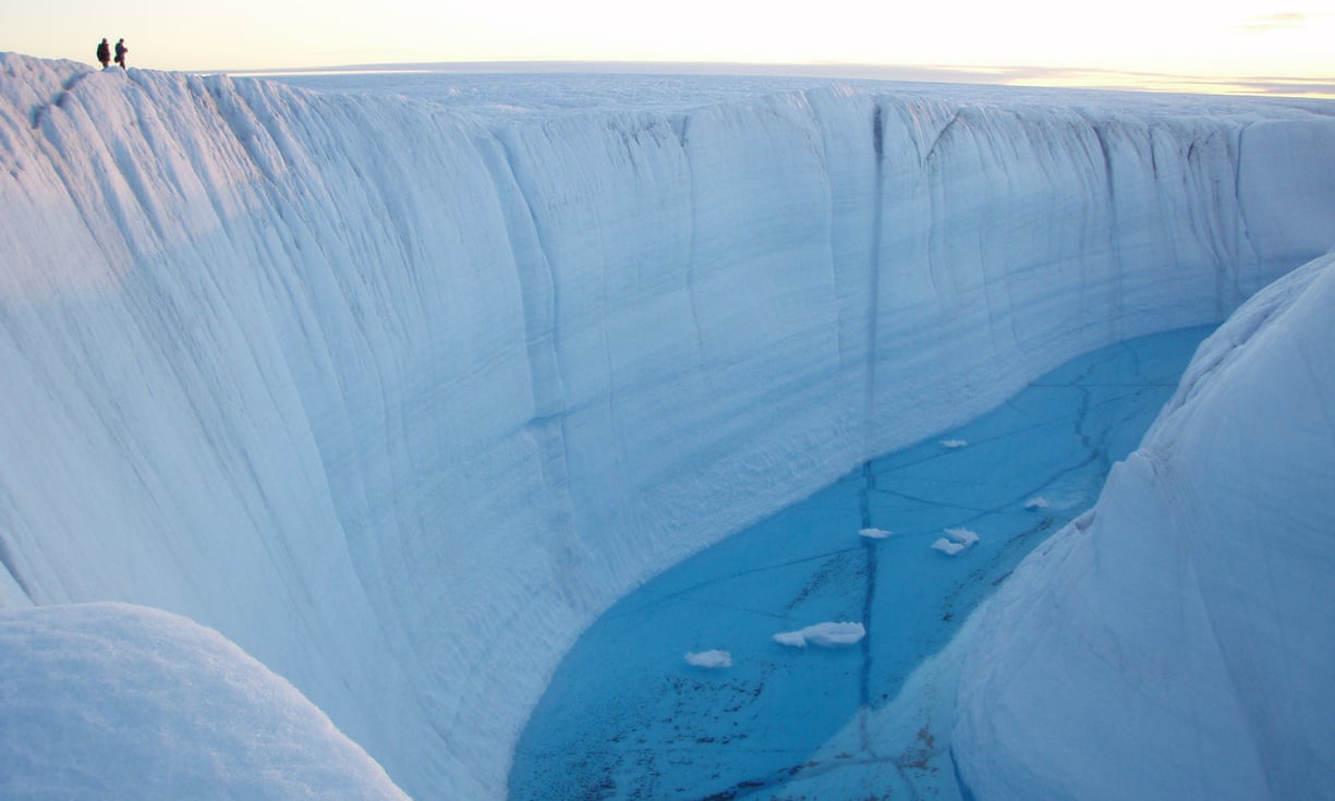
Scientists say the world’s oceans are warming far more quickly than previously thought, a finding with dire implications for climate change because almost all the excess heat absorbed by the planet ends up stored in their waters.
A new analysis, published Thursday in the journal Science, found that the oceans are heating up 40 percent faster on average than a United Nations panel estimated five years ago.
The researchers also concluded that ocean temperatures have broken records for several straight years.
“2018 is going to be the warmest year on record for the Earth’s oceans,” said Zeke Hausfather, an energy systems analyst at the independent climate research group Berkeley Earth and an author of the study.
“As 2017 was the warmest year, and 2016 was the warmest year.”
Past and future ocean heat content changes Annual
observational OHC changes are consistent with each other and consistent
with the ensemble means of the CMIP5 models for historical simulations
pre-2005 and projections from 2005–2017, giving confidence in future
projections to 2100 (RCP2.6 and RCP8.5) (see the supplementary
materials).
The mean projected OHC changes and their 90% confidence intervals between 2081 and 2100 are shown in bars at the right.
The
inset depicts the detailed OHC changes after January 1990, using the
monthly OHC changes updated to September 2018, along with the other
annual observed values superposed.
graphic: N. Cary/ScienceMag
As the planet has warmed, the oceans have provided a critical buffer.
They have slowed the effects of climate change by absorbing 93 percent of the heat trapped by the greenhouse gases humans pump into the atmosphere.
“If the ocean wasn’t absorbing as much heat, the surface of the land would heat up much faster than it is right now,” said Malin L. Pinsky, an associate professor in the department of ecology, evolution and natural resources at Rutgers University.
“In fact, the ocean is saving us from massive warming right now.”
But the surging water temperatures are already killing off marine ecosystems, raising sea levels and making hurricanes more destructive.
As the oceans continue to heat up, those effects will become more catastrophic, scientists say.
Rainier, more powerful storms like Hurricane Harvey in 2017 and Hurricane Florence in 2018 will become more common, and coastlines around the world will flood more frequently.
Coral reefs, whose fish populations are sources of food for hundreds of millions of people, will come under increasing stress; a fifth of all corals have already died in the past three years.
People in the tropics, who rely heavily on fish for protein, could be hard hit, said Kathryn Matthews, deputy chief scientist for the conservation group Oceana.
“The actual ability of the warm oceans to produce food is much lower, so that means they’re going to be more quickly approaching food insecurity,” she said.
Because they play such a critical role in global warming, oceans are one of the most important areas of research for climate scientists.
Average ocean temperatures are also a consistent way to track the effects of greenhouse gas emissions because they are not influenced much by short-term weather patterns, Mr. Hausfather said.
“Oceans are really the best thermometer we have for changes in the Earth,” he said.
But, historically, understanding ocean temperatures has been difficult. An authoritative United Nations report, issued in 2014 by the Intergovernmental Panel on Climate Change, presented five different estimates of ocean heat, but they all showed less warming than the levels projected by computer climate models — suggesting that either the ocean heat measurements or the climate models were inaccurate.
Since the early 2000s, scientists have measured ocean heat using a network of drifting floats called Argo, named after Jason’s ship in Greek mythology.
The floats measure the temperature and saltiness of the upper 6,500 feet of the ocean and upload the data via satellites.
An ocean sensor deployed by the French research ship Pourquoi Pas? as part of the Argo project.
Since
the mid-2000s, a fleet of nearly 4,000 floating robots have been
drifting throughout Earth’s oceans, every few days diving to a depth of
about 1.25 miles (2,000 meters) and measuring the ocean’s temperature,
pH, salinity and other bits of information as they rise back up.
But before Argo, researchers relied on temperature sensors that ships lowered into the ocean with copper wire.
The wire transferred data from the sensor to the ship for recording until the wire broke and the sensor drifted away.
That method was subject to uncertainties, particularly around the accuracy of the depth at which the measurement was taken.
Those uncertainties hamper today’s scientists as they stitch together 20th-century temperature data into a global historical record.
In the new analysis, Mr. Hausfather and his colleagues assessed three recent studies that better accounted for the older instrument biases.
The results converged at an estimate of ocean warming that was higher than that of the 2014 United Nations report and more in line with the climate models.
The waters closest to the surface have heated up the most, and that warming has accelerated over the past two decades, according to data from the lead author of the new study, Lijing Cheng of the Institute of Atmospheric Physics in Beijing.
The oceans are heating up
As the oceans heat up, sea levels rise because warmer water takes up more space than colder water.
In fact, most of the sea level rise observed to date is because of this warming effect, not melting ice caps.
Absent global action to reduce carbon emissions, the authors said, the warming alone would cause sea levels to rise by about a foot by 2100, and the ice caps would contribute more.
That could exacerbate damages from severe coastal flooding and storm surge.
The effects of the warming on marine life could also have broad repercussions, Dr. Pinsky said.
“As the ocean heats up, it’s driving fish into new places, and we’re already seeing that that’s driving conflict between countries,” he said.
“It’s spilling over far beyond just fish, it’s turned into trade wars. It’s turned into diplomatic disputes.
It’s led to a breakdown in international relations in some cases.”
A fourth study reviewed by the researchers strengthened their conclusions.
That study used a novel method to estimate ocean temperatures indirectly, and it also found that the world’s oceans were heating faster than the authors of the 2014 study did.
The study initially contained an error that caused its authors to revise their estimates downward.
But as it turned out, the downward revision brought the study’s estimates much closer to the new consensus.
“The correction made it agree a lot better with the other new observational records,” Mr. Hausfather said.
“Previously it showed significantly more warming than anyone, and that was potentially worrisome because it meant our observational estimates might be problematic.
Now their best estimate is pretty much dead-on with the other three recent studies.”
The scientists who published the four studies were not trying to make their results align, Mr.
Hausfather said.
“The groups who were working on ocean heat observations, they’re not climate modelers,” he said.
“They’re not particularly concerned with whether or not their observations agree or disagree with climate models.”
Laure Zanna, an associate professor of climate physics at the University of Oxford who was not involved in the study, said the new research was “a very nice summary of what we know of the ocean and how far the new estimates have come together.”
Rising ocean temperatures can bleach corals, like these off of Papua New Guinea.
Credit : Jurgen Freund/NPL/Minden Pictures
Dr. Zanna published a study this week that used existing data to estimate ocean temperatures dating back to 1871.
The goal was to figure out places where sea level rise might happen even faster than expected because of the way ocean currents redistribute heat, allowing regions that are especially at risk to better plan for those changes.
“We are warming the planet but the ocean is not warming evenly, so different places warm more than others,” Dr.
Zanna said.
“And so the first consequence will be that sea level will be different in different places depending on the warming.”
Though the new findings provide a grim forecast for the future of the oceans, Mr.
Hausfather said that efforts to mitigate global warming, including the 2015 Paris climate agreement, would help.
“I think there’s some reason for confidence that we’ll avoid the worst-case outcomes,” he said, “even if we’re not on track for the outcomes we want.”
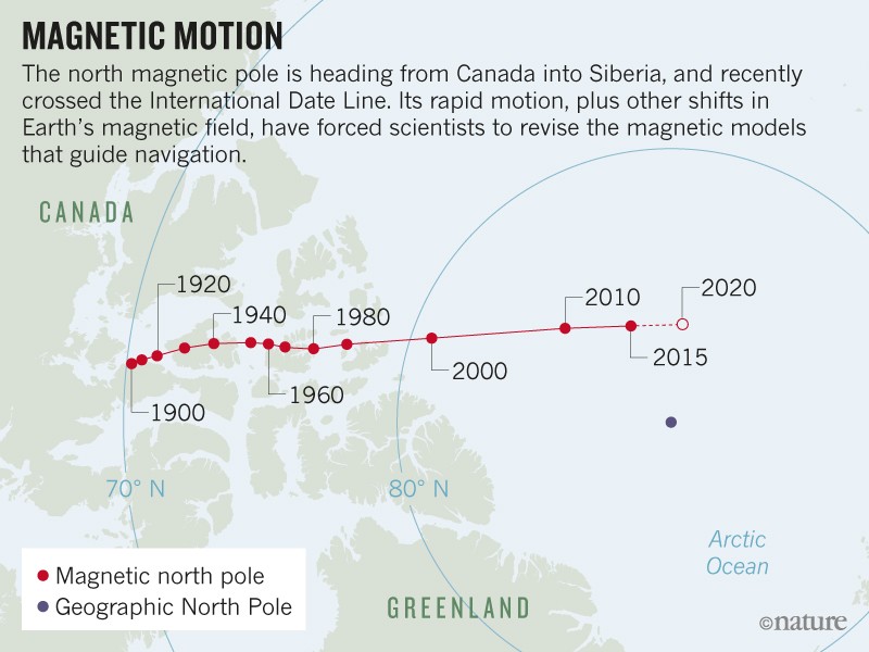
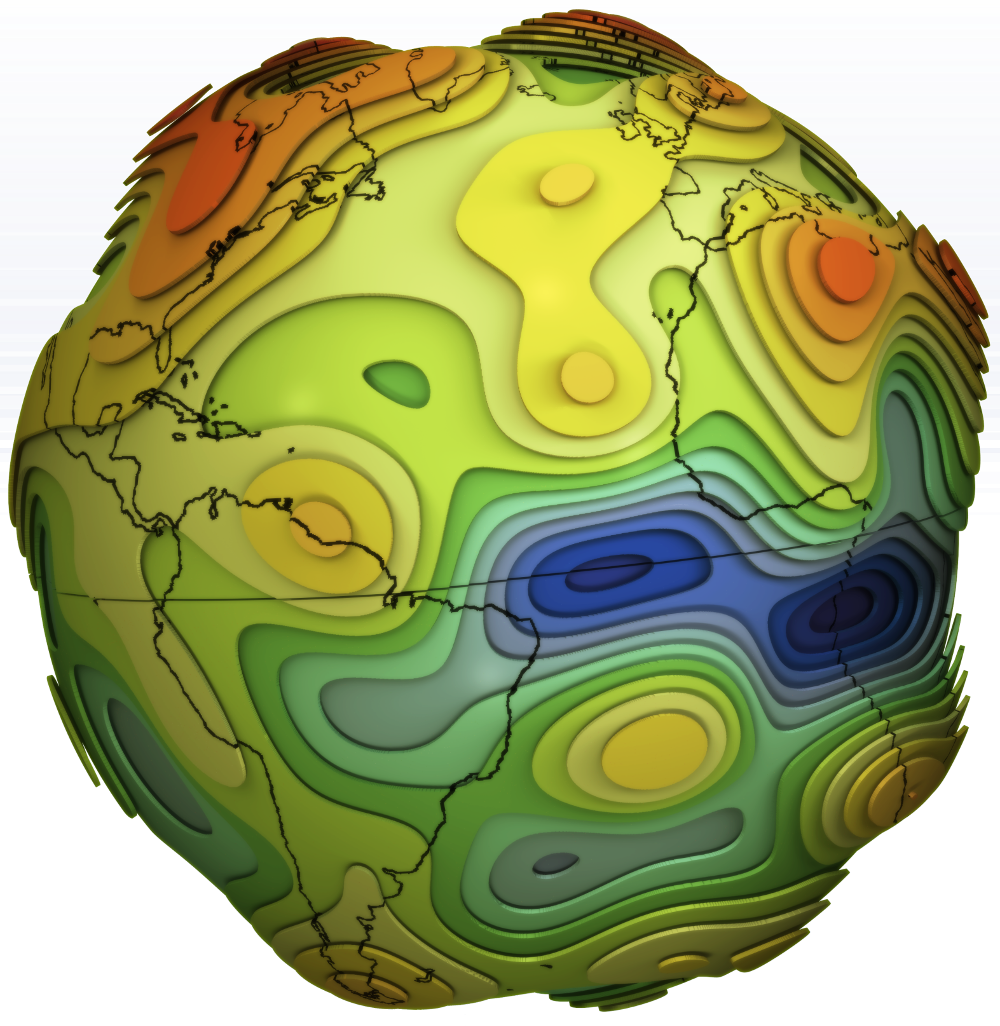
Erratic motion of north magnetic pole forces experts to update model that aids global navigation.
Something strange is going on at the top of the world.
Earth’s north magnetic pole has been skittering away from Canada and towards Siberia, driven by liquid iron sloshing within the planet’s core.
The magnetic pole is moving so quickly that it has forced the world’s geomagnetism experts into a rare move.
The movement of the Earth's magnetic poles are shown in this animation at 10-year intervals from 1970 to 2020.
The red and blue lines show the difference between magnetic north and true north depending on where you are standing. On the green line, a compass would point to true north.
credit : NOAA National Centres for Environmental Information.
On 15 January, they are set to update the World Magnetic Model, which describes the planet’s magnetic field and underlies all modern navigation, from the systems that steer ships at sea to Google Maps on smartphones. Note : Actually, the release of the World Magnetic Model has been postponed to 30 January due to the ongoing US government shutdown.
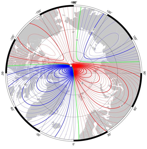
Declination (magnetic variation) in region of north pole at 2015.0 from the World Magnetic Model .
Red - positive (east), blue - negative (west), black - zero. Contour interval is 5°.
The most recent version of the model came out in 2015 and was supposed to last until 2020 — but the magnetic field is changing so rapidly that researchers have to fix the model now.
“The error is increasing all the time,” says Arnaud Chulliat, a geomagnetist at the University of Colorado Boulder and the National Oceanic and Atmospheric Administration’s (NOAA’s) National Centers for Environmental Information.
Earth Magnetic Field Declination from 1590 to 1990
source USGS
The problem lies partly with the moving pole and partly with other shifts deep within the planet.
Liquid churning in Earth’s core generates most of the magnetic field, which varies over time as the deep flows change.
In 2016, for instance, part of the magnetic field temporarily accelerated deep under northern South America and the eastern Pacific Ocean.
Satellites such as the European Space Agency’s Swarm mission tracked the shift.
By early 2018, the World Magnetic Model was in trouble.
Researchers from NOAA and the British Geological Survey in Edinburgh had been doing their annual check of how well the model was capturing all the variations in Earth’s magnetic field.
They realized that it was so inaccurate that it was about to exceed the acceptable limit for navigational errors.
Mag.num - Model of the geomagnetic core field, based on Swarm satellite and observatory data Vertical component of the Earth's Magnetic Field at CMB. (GFZ Potsdam)
Wandering pole
“That was an interesting situation we found ourselves in,” says Chulliat.
“What’s happening?”
The answer is twofold, he reported last month at a meeting of the American Geophysical Union in Washington DC.
First, that 2016 geomagnetic pulse beneath South America came at the worst possible time, just after the 2015 update to the World Magnetic Model.
This meant that the magnetic field had lurched just after the latest update, in ways that planners had not anticipated.
Second, the motion of the north magnetic pole made the problem worse.
The pole wanders in unpredictable ways that have fascinated explorers and scientists since James Clark Ross first measured it in 1831 in the Canadian Arctic.
In the mid-1990s it picked up speed, from around 15 kilometres per year to around 55 kilometres per year.
By 2001, it had entered the Arctic Ocean — where, in 2007, a team including Chulliat landed an aeroplane on the sea ice in an attempt to locate the pole.
This animation shows changes in Earth's magnetic field from January to June 2014 as measured by ESA's Swarm trio of satellites.
The magnetic field protects us from cosmic radiation and charged particles that bombard Earth, but it is in a permanent state of flux.
Magnetic north wanders, and every few hundred thousand years the polarity flips so that a compass would point south instead of north.
Moreover, the strength of the magnetic field constantly changes -- and it is currently showing signs of significant weakening.
The field is particularly weak over the South Atlantic Ocean -- known as the South Atlantic Anomaly.
This weak field has indirectly caused many temporary satellite 'hiccups' (called Single Event Upsets) as the satellites are exposed to strong radiation over this area.
In 2018, the pole crossed the International Date Line into the Eastern Hemisphere.
It is currently making a beeline for Siberia.
The geometry of Earth’s magnetic field magnifies the model’s errors in places where the field is changing quickly, such as the North Pole.
“The fact that the pole is going fast makes this region more prone to large errors,” says Chulliat.
To fix the World Magnetic Model, he and his colleagues fed it three years of recent data, which included the 2016 geomagnetic pulse.
The new version should remain accurate, he says, until the next regularly scheduled update in 2020.
Annual rate of change of declination for 2015.0 to 2020.0 from the World Magnetic Model (WMM2015).
Red –easterly change, blue – westerly change, green – zero change. Contour interval is 2’/year (1/30th of a degree), white star is location of a magnetic pole and projection is Mercator
In the meantime, scientists are working to understand why the magnetic field is changing so dramatically.
Geomagnetic pulses, like the one that happened in 2016, might be traced back to ‘hydromagnetic’ waves arising from deep in the core.
And the fast motion of the north magnetic pole could be linked to a high-speed jet of liquid iron beneath Canada.
The jet seems to be smearing out and weakening the magnetic field beneath Canada, Phil Livermore, a geomagnetist at the University of Leeds, UK, said at the American Geophysical Union meeting.
And that means that Canada is essentially losing a magnetic tug-of-war with Siberia.
“The location of the north magnetic pole appears to be governed by two large-scale patches of magnetic field, one beneath Canada and one beneath Siberia,” Livermore says.
“The Siberian patch is winning the competition.”
Which means that the world’s geomagnetists will have a lot to keep them busy for the foreseeable future.
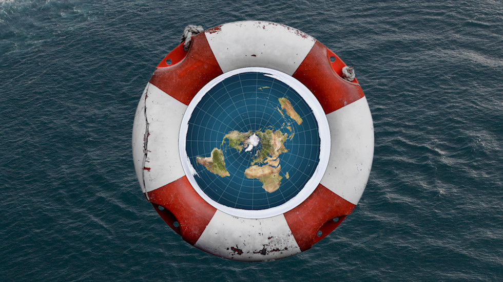
“Though there are varying models within the flat earth community, the most commonly depicted model of our earth is that of a circular disk with Antarctica serving as an ice wall barrier,” the organization writes in its FAQ section.
Flat earthers, who believe the Earth is a large disk, may be shocked to find the ship’s navigation is based on a spherical planet
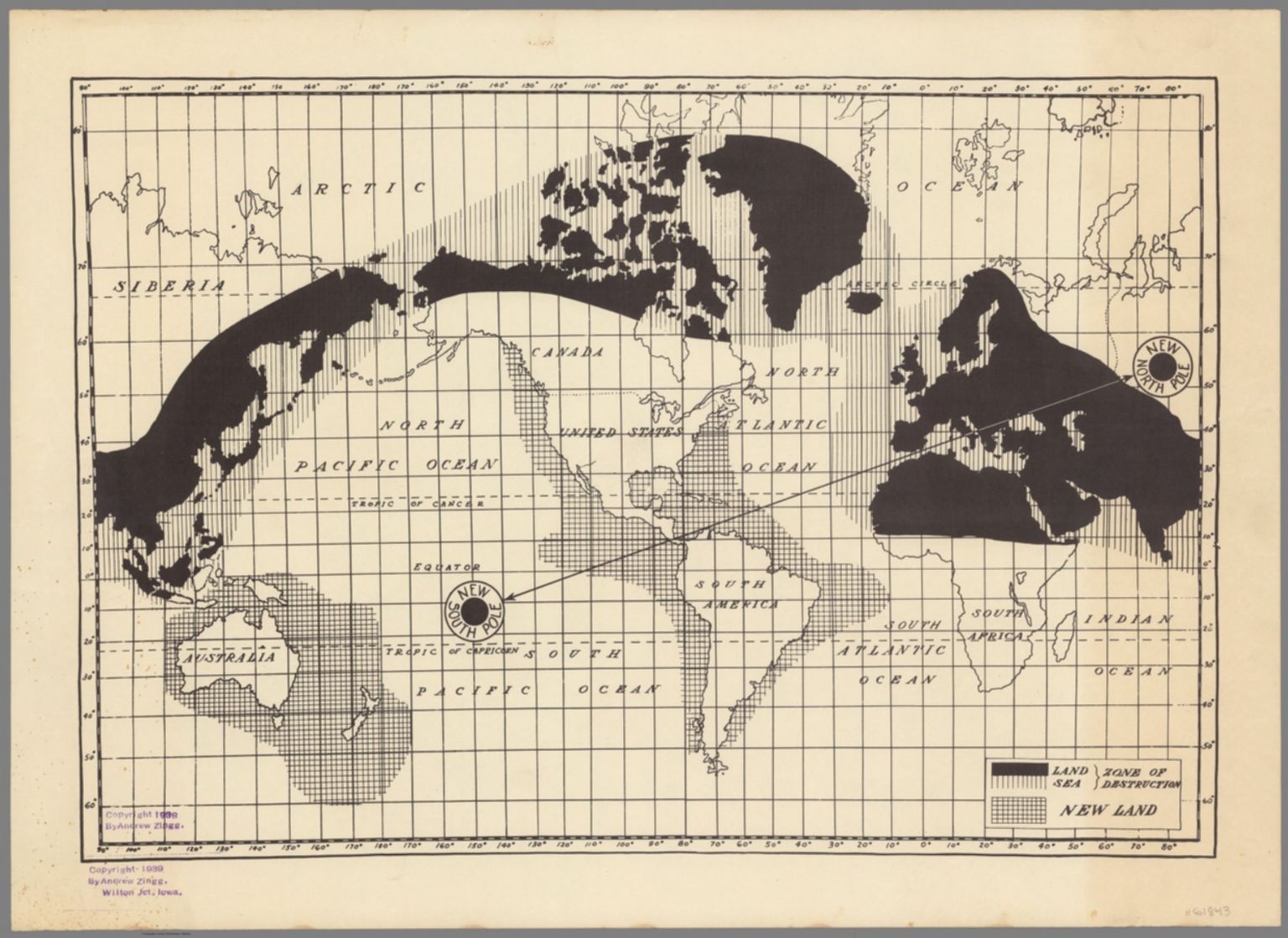
"Flat Earth" type nonsense isn't new. This 1938 map depicts an
"inspirational vision" suggesting the world's axis would shift,
resulting in massive climate change, as well as lifting up of some
bodies of land, and a submerging of others.
A group of people who believe the Earth is flat have announced their “biggest, boldest, best adventure yet”: a Flat Earth cruise scheduled for 2020.
Tim O'Brien painting
The cruise, organized by the Flat Earth International Conference, promises to be a lovely time.
Flat earthers – who include the rapper B.o.B. and reality television person Tila Tequila – will be able to enjoy restaurants, swimming pools and perhaps even an artificial surf wave.
Vniversale descrittione di tvtta la terra conoscivta fin qvi. Ferando Berteli, 1565,
based on an earlier map by Giacomo Gastaldi
(source LOC)
There’s just one problem for those seeking to celebrate the flatness of the Earth.
The navigational systems cruise ships, and other vessels, use rely on the fact that the Earth is not flat: theoretically puncturing the beliefs of the flat Earth crowd.
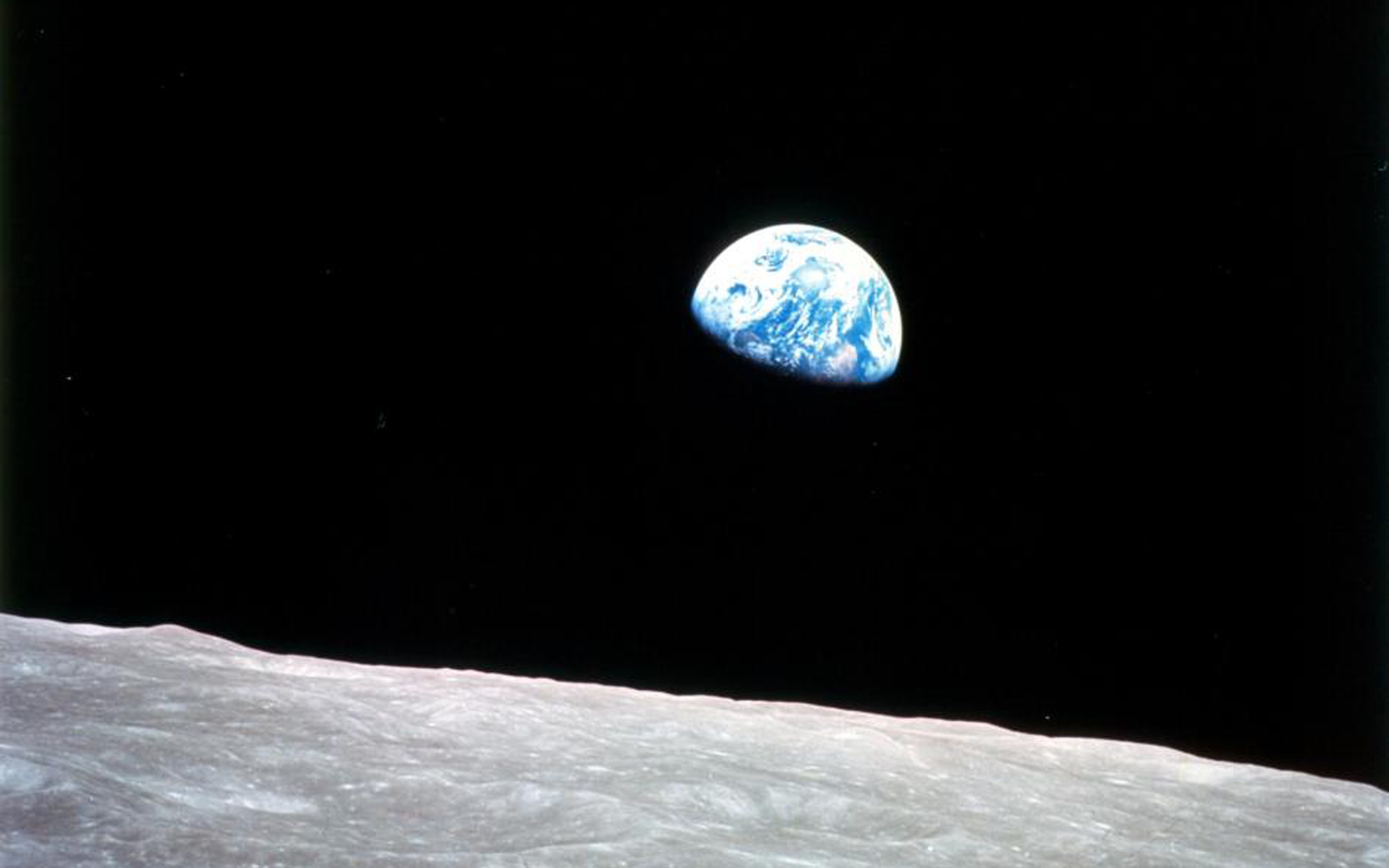
This iconic image speaks volumes.
To many it underscores the vastness of space, the loneliness of the cosmos and how fragile our home planet really is.
Entitled “Earthrise,” it was taken by astronaut William Anders during an orbit of the moon as part of the Apollo 8 mission.
Apollo 8 was the first manned mission to the moon, which entered the Moon’s orbit on Christmas Eve 1968.
That evening, the astronauts onboard held a live broadcast, in which they showed pictures of the Earth and moon as seen from their spacecraft. Command Module Pilot Jim Lovell said, "The vast loneliness is awe-inspiring and it makes you realize just what you have back there on Earth."
The astronauts ended the broadcast with the crew taking turns reading from the book of Genesis.
“Ships navigate based on the principle that the Earth is round,” said Henk Keijer, a former cruise ship captain who sailed all over the globe during a 23-year career.
“Nautical charts are designed with that in mind: that the Earth is round.”
Keijer, who now works as a forensic marine expert for Robson Forensic, said the existence of GPS, the global positioning system, alone is proof that the Earth is a sphere, not a flat disc. GPS relies on 24 main satellites which orbit the Earth to provide positional and navigational information.
“The reason why 24 satellites were used is because on the curvature of the Earth,” Keijer said.
“A minimum of three satellites are required to determine a position. But someone located on the other side of the Earth would also like to know their position, so they also require a certain number of satellites.
“Had the Earth been flat, a total of three satellites would have been enough to provide this information to everyone on Earth. But it is not enough, because the Earth is round.”
Proof of the sphericity of the Earth advanced by Pliny the Elder
(and not by Aristotle, as is often said.) Low-resolution
digitization of a figure published in the book Voyages des Astronomes
français à la recherche de la figure de la terre et de ses dimensions by
Abbé J. Loridan (Desclée, de Brouwer et Cie, Lille, 1890).
While there are different theories within the Flat Earth community, the core belief is the Earth is flat.
The FEIC claims that after “extensive experimentation, analysis, and research”, its adherents came to believe the Earth is not a sphere.
A common model offered for the exact topography of the Earth is that it is a large disk, surrounded by “an ice wall barrier” – Antarctica.
credit : RT composite
The Flat Earth Society, which is not connected to the FEIC, has suggested that “the space agencies of the world” have conspired to fake “space travel and exploration”.
“This likely began during the cold war,” the Flat Earth Society says.
“The USSR and USA were obsessed with beating each other into space to the point that each faked their accomplishments in an attempt to keep pace with the other’s supposed achievements.”
"The Roulette Wheel Earth Theory" by Orlando Ferguson (1893) That awkward moment when the flat earth isn’t even flat. In contrast, the Square Earth Theory is based on its formulator's novel interpretation of certain Bible passages, dependent on a belief that God is incapable of symbolism, metaphor, and allegory.
This theory would presumably have no gravitational problems as those would be taken care of by God.
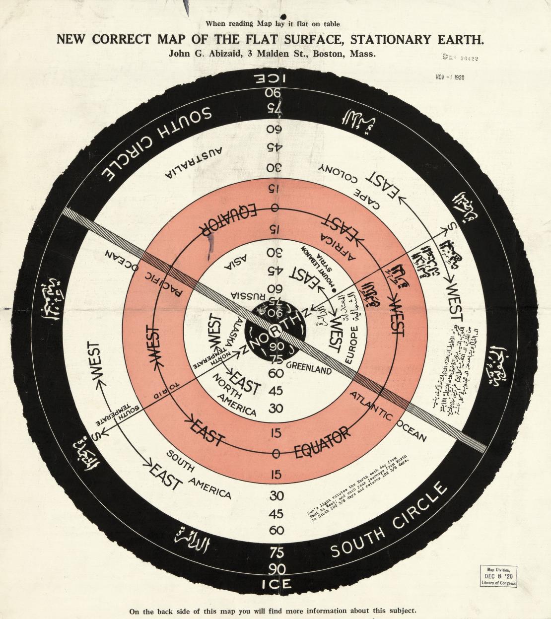
New correct map of the flat surface, stationary earth
Other TitleWhen reading map lay it flat on table
Contributor Names : Abizaid, John George, 1868-
source : LOC
The FEIC did not respond to requests for more information on the Flat Earth cruise.
"Not amount of evidence will ever persuade an idiot"
Mark Twain quote
The organization could potentially try to staff the cruise ship with a crew which does not think the Earth is round, but Keijer said that would be difficult.
“I have sailed 2 million miles, give or take,” Keijer said.
“I have not encountered one sea captain who believes the Earth is flat.”


.jpg)