Saturday, January 5, 2013

Timelapse of swarming monster worms and sea stars


Three-foot nemertean worms and carnivorous sea stars prowl the Antarctic in search of flesh.
Finding a dead seal, the sea stars inject it with digestive juices ... then suck it up like soup.

Friday, January 4, 2013

Rig runs aground in Alaska, reviving fears about Arctic drilling


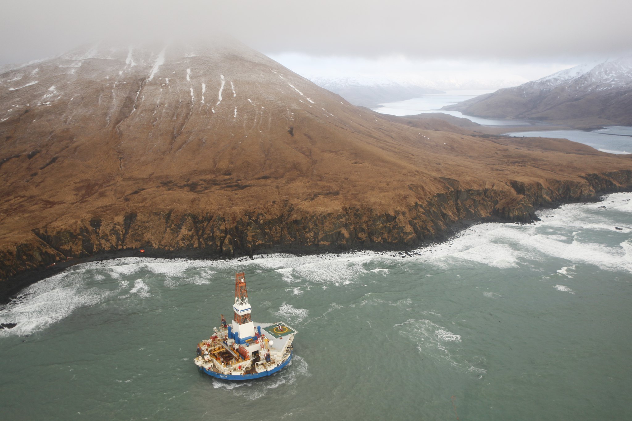
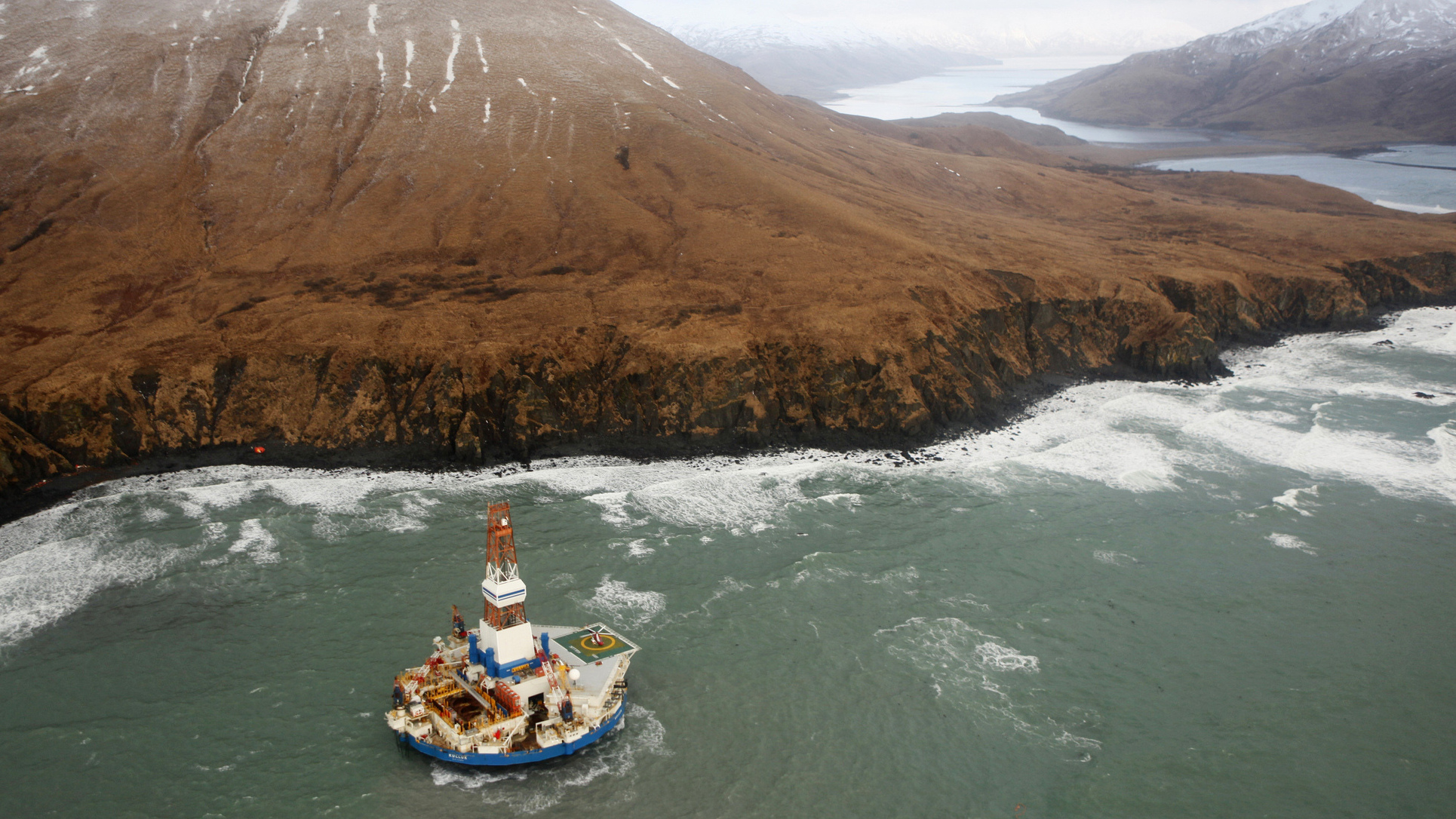
Coast Guard overflight of Kulluk aground

From NYT

One of Shell Oil’s two Arctic drilling rigs is beached on an island in the Gulf of Alaska, threatening environmental damage from a fuel spill and calling into question Shell’s plans to resume drilling in the treacherous waters north of Alaska in the summer.

The rig, the Kulluk, broke free from a tow ship in stormy seas and ran aground Monday night.

site where oil rig ran aground on Sitkalidak island, close to Kodiak island in the Gulf of Alaska
 >>> geolocalization with the Marine GeoGarage <<<

The Coast Guard was leading an effort to keep its more than 150,000 gallons of diesel fuel and lubricants from spilling onto the rocky shoreline.

At a news conference in Anchorage on Tuesday afternoon, Capt. Paul Mehler III, the federal on-scene coordinator, said that a reconnaissance flight showed the Kulluk was upright and stable, with no significant motion.
“The results are showing us that the Kulluk is sound,” Captain Mehler said.
“No sign of breach of hull, no sign of release of any product.”
He said the response team hoped to get salvage experts aboard the ship to get a better picture of damage.


Steven Russell of the Alaska Department of Environmental Conservation said that, so far, there was no sign of harm to the environment or wildlife.
The Kulluk’s 18 crew members had been evacuated by Coast Guard helicopters on Saturday after the rig first went adrift in high winds and rough seas.

The grounding was the latest in a series of mishaps to befall Shell’s ambitious plans to prospect for oil in the Beaufort and Chukchi Seas off the North Slope of Alaska.
Shell halted drilling for oil in September after equipment failures, unexpected ice floes, operational missteps and regulatory delays forced the company to scale back its plans.

Its drilling rigs completed two shallow pilot holes and left the Arctic in late fall to return to Seattle for maintenance work but have encountered problems in transit.

If the Kulluk, which Shell upgraded in recent years at a cost of nearly $300 million, is wrecked or substantially damaged, it will be hard for the company to find a replacement and receive the numerous government permits needed to resume drilling in July, as planned.

Under Department of Interior rules governing Arctic drilling, the company must have two rigs on site at all times to provide for a backup vessel to drill a relief well in case of a blowout, an uncontrolled escape of oil or gas.

A separate containment system designed to collect oil in the case of a well accident failed during testing, preventing Shell from drilling into oil-bearing formations during its abbreviated exploration season last summer and fall.
Shell’s Alaska vice president, Pete Slaiby, said he could not discuss the latest accident, saying that company officials were working with a Coast Guard-directed unified command and could not comment separately.

An official involved in the response operation, who spoke on the condition of anonymity because he was not authorized to comment, said: “We don’t know about the damage.It’s too dark.The weather is horrendous.” The official said that when a helicopter flew over the rig Monday night: “It looked upright about 1,600 feet off the beach. There was no sign of any spill.”
The official said the fuel tanks on the vessel were well protected inside the hull, making a spill unlikely.

The Kulluk, which does not have a propulsion system of its own, ran into trouble late last week when its tow ship, the Aiviq, lost engine power and the towline separated.
A Coast Guard cutter and other ships arrived, and crews struggled through Monday, in seas up to 35 feet, to reconnect tow lines to the rig, succeeding several times.
But each time the lines separated.

On Monday night, the Kulluk, 266 feet in diameter, broke free from one tow ship and the Coast Guard ordered a second ship to disconnect, fearing for the safety of its crew.

 High-resolution satellite image showing the drill rig Kulluk aground
off the coast of Alaska on January 4, 2013.
Image courtesy DigitalGlobe

The Kulluk is sitting on the southeast coast of Sitkalidak Island, an uninhabited island separated by the Sitkalidak Strait from the far larger Kodiak Island to the west.
The nearest town, Old Harbor, is across the strait on Kodiak Island; it has a population of about 200 people. The strait is home to a threatened species of sea lion.

A spokesman for the Interior Department’s offshore drilling safety office would not say whether the latest problem would cause a re-evaluation of the agency’s approval of Shell’s overall Arctic program.
But the spokesman, Nicholas Pardi of the Bureau of Safety and Environmental Enforcement, said that any equipment Shell proposes to use off the Alaskan coast must meet federal safety and testing standards.
He added that regulations require a federal inspector be present around the clock during drilling operations.

The other ship Shell has used in the Arctic, the Noble Discoverer, has had problems of its own. In July, before sailing to the Arctic, it nearly ran aground after dragging its anchor in the Aleutian Islands.
Then in November it had a small engine fire.

Later that month, during an inspection in the Alaskan port of Seward, the Coast Guard found more than a dozen violations involving safety systems and pollution equipment.
Last week, the Noble Corporation, the Swiss company that owns the 512-foot-long drillship and is leasing it to Shell for $240,000 a day, said that many of the problems had been repaired and that the ship was preparing to sail to Seattle to fix the remainder of them.

Critics said that the accident confirmed their worst fears about Shell’s Arctic project and should force federal regulators to stop it.
“We’re learning that oceans, while beautiful, are dangerous and unforgiving,” said Michael LeVine, senior Pacific counsel for the environmental group Oceana.
“Shell has demonstrated again and again that it’s not prepared to operate in Alaskan waters. Hopefully something good will come out of this latest incident, and the government will take a careful look at whether activities such as this can be conducted safely, and if so, what changes are needed to make that possible.”

Shell was on the verge of drilling in 2011, but delays in getting final approval for an air quality permit forced the company to put off drilling until 2012.
More equipment failures and unpredictable weather continued through the year.
In September, Shell had to abandon preliminary drilling in the Chukchi Sea when sea ice moved toward the drilling area only a day after work began.

And finally, the company was forced to put off completing the two wells it had begun to drill for another year when a barge containing a spill containment dome was badly damaged during a testing accident.
During the testing, a mechanical device malfunctioned as the containment dome was lowered into the water, and a submarine robot became tangled in some of the dome’s anchor lines.

Links :

Thursday, January 3, 2013

Shorebreaks


Clark Little

A short quick fix promo of some of the best explosive shorebreak clips from Clark Little Photography.
Don't flinch...

Wednesday, January 2, 2013

Vendee Globe : South Atlantic Ocean islands

situation 02/01/2013 04:00 UTC

>>> geolocalization with the Marine GeoGarage <<<

Isla de los Estados (English: Staten Island, from the Dutch Stateneiland) is an Argentine island that lies 29 kilometres (18 mi) off the eastern extremity of the Argentine portion of Tierra del Fuego, from which it is separated by the Le Maire Strait.
It was named for the Netherlands States-General, and its original Dutch name was identical to that of the New York borough of Staten Island.

 San Juan de Salvamento lighthouse on the east coast of the remote Isla de los Estados,
made famous by Jules Verne in the novel The Lighthouse at the End of the World
The remains of the original lighthouse were moved to Ushuaia and a reconstruction of the lighthouse was finished at the museum in 1997.
At the original site a reproduction of the lighthouse was created in 1998
by a society of French fans of Jules Verne who worked with the Argentine Navy.
This reproduction is now an active aid to navigation.

Falkland Islands (above) UKHO / Islas Malvinas (below) SHN
>>> geolocalization with the Marine GeoGarage <<<

The Falkland Islands (Spanish: Islas Malvinas) are an archipelago located in the South Atlantic Ocean on the Patagonian Shelf.
The principal islands are about 310 miles (500 kilometres) east of the Patagoinian coast at a latitude of about 52°S.
The archipelago which has an area of 4,700 square miles (12,173 square kilometres) comprises East Falkland, West Falklandand 776 smaller islands.
The islands, a British Overseas Territory, enjoy a large degree of internal self-government with the United Kingdom guaranteeing good government and taking responsibility for their defence and foreign affairs.


Controversy exists over the Falklands' original discovery and subsequent colonisation by Europeans. At various times there have been French, British, Spanish, and Argentine settlements. Britain re-established its rule in 1833, though the islands continue to be claimed by Argentina.
In 1982, following Argentina's invasion of the islands, the two-month-long undeclared Falklands War between both countries resulted in the surrender of all Argentine forces and the return of the islands to British administration.

Oil exploration, licensed by the Falkland Islands Government, remains controversial as a result of maritime disputes with Argentina.

 German map from 1844, hence the number of German terms appearing on it.
Most of the French names have disappeared leaving mainly English names with a few Spanish ones.
Port Egmont is still marked on the map.
This map divides the islands up into East and a West Falkland Island.
This map credits the discovery of the islands to Davis in 1592.

A map showing the Falkland Islands prior to 1794 with marginal notes describing the division of the Islands between British West Falkland and Spanish East Falkland.
Part of a "Map of South America containing Terra-Firma, Guayana, New Granada, Amazonia, Brasil, Peru, Paraguay, Chaco, Tucuman, Chili and Patagonia with a chart of Falkland's Islands named by the French Malouine Islands and discovered by Hawkins in the year 1593.

South Georgia and the South Sandwich Islands
South Georgia (above) UKHO / Isla San Pedro (below) SHN
 >>> geolocalization with the Marine GeoGarage <<<


South Georgia and the South Sandwich Islands (SGSSI) is a British overseas territory in the southern Atlantic Ocean.
It is a remote and inhospitable collection of islands, consisting of South Georgia and a chain of smaller islands, known as the South Sandwich Islands.
The United Kingdom claimed sovereignty over South Georgia in 1775 and the South Sandwich Islands in 1908. In 1908 the United Kingdom annexed both South Georgia and the South Sandwich Islands.
Argentina continues to claim sovereignty over South Georgia and the South Sandwich Island.

 Capt. Isaac Pendleton, South Georgia (1802);
Southatlantic Ocean: Discovered by the Frenchman La Roche in the year 1675.

 A colony of King Penguins - St. Andrew’s Bay, South Georgia
(photo Tony Beck

Links :

China switches on BeiDou Compass 'BDS' civilian nav-sat rival to GPS

BeiDou (Compass) coverage
Maritime and river transportation is the world's most widely mode of transportation, and also one of the earliest application areas of satellite navigation.
Nowadays satellite navigation terminal equipment are installed in almost all kinds of vessels over any ocean, river or lake, maritime and river transportation is becoming more efficient and safer.
BeiDou(COMPASS)Navigation Satellite System will, in any weather conditions, provide navigation, positioning and security guarantee for vessels on voyage.
Furthermore, BeiDou’s unique short message communication function will support various new service development.

From TheRegister

China's Beidou satellite navigation system has gone live to civilians, providing the Chinese public with accuracy comparable to GPS without reliance on American military hardware.

Beidou's coverage isn't global yet, the Chinese only have half a dozen satellites in the sky (compared to the 33 GPS birds aloft right now, albeit a few of them not usable at present), but the civilian system is accurate to the ten meters or so guaranteed by GPS and has the distinct advantage of falling outside the control of the US military - who reserve the option of denying GPS service, though this has never actually happened.
Twenty-four spacecraft are required for global coverage, but users notice a distinctly better service if there are 30 or more as with GPS right now.

The Beidou system officially came into operation more than a decade ago, but version one was based on geostationary satellites to which navigation devices had to send a signal.
The timed reception of that signal was collated by an earth station to calculate the location, which then had to be sent to the user - if that was necessary (the system was mostly used for tracking vehicles, rather than navigation).

Version 2 is also known as Compass, though China Daily is now calling it the BeiDou Satellite System (BDS), but technically it's comparable to GPS in that navigation devices receive precisely-timed signals and calculate their own location, needing at least four satellites above the horizon to get a decent fix, and whatever it's called it is now live.

There's also a licensed (military/governmental) signal, which offers higher accuracy and has been in use for a while, but there aren't so many details on that available.

The Chinese don't trust GPS because the US controls it, not only globally but regionally too.
Such action wouldn't need a shooting war; one could envision GPS on the table during a trade dispute, and if a shooting war did kick off (in, say, North Korea) then switching off the opponent's navigation systems could be a powerful weapon.

Furthermore, an intercontinental nuclear missile needs satellite navigation to strike with accuracy: unaided inertial and star-sight guidance will suffice for a nuke to destroy a city, but if the target is - for example - a hardened underground missile silo or deep bunker, sat-nav will be required for a nuke to knock it out.
This is the main reason why the US originally built GPS, in fact.

Funnily enough Russia also had a sat-nav system back in Cold War times, and now that finances are a little better in the Kremlin, Moscow has recently been getting its Glonass constellation back into order.
Glonass had fallen into disrepair but now has more than 20 operational birds - though last week Russia Today reported that the planned handover to the Defence Ministry was stalled, following accusations of corruption and technical failures.

Some European nations, notably the UK, feel no great need for our own sat-nav constellation: but others chafe at the thought of not being able to make precision nuclear (or conventional) strikes without US consent - and perhaps, at the thought of the US being able to cut off an increasingly vital civilian service* - and so Europe is building its own navigation array also.

Galileo only has three birds in the sky right now, so is some way off being operational, but the EU publicly guarantees that it will never be switched off.
The system is also characterised as entirely civilian, though the encrypted government-users-only "public regulated navigation" Galileo service will offer the French and British nuclear forces (and the conventional armed services of the EU) much the same capabilities as the encrypted GPS military channel delivers to the US military and its allies.


The good news is that all these systems use similar frequencies (sometimes the same frequency, which is a looming problem) so devices should be able to use multiple sat-nav networks to increase accuracy and get a faster fix, just as long as the respective military masters don't hit the kill switch.
In particular, the Galileo and GPS civilian services have been specifically set up so that a single receiver can use both at once.


With the GPS fleet set to drop below 30 in coming years due to funding and technical issues in the States (though not below 24) multi-constellation receivers are likely to become popular as and when Galileo, Beidou and Glonass get up and running for real

Bootnote
*Apart from determining location, a GPS receiver is also an extremely accurate clock: being literally as cheap as chips, it is often used as such and so becomes important for such lesser-known things as keeping cellphone networks running, for instance.

Monday, December 31, 2012

Vendee Globe : Cape Horn and ice danger

A tour of Cape Horn with Sir Robin Knox-Johnston
Extracts from a magnificent one hour BBC 2 documentary of Sir Robin Knox-Johnston and Skip Novak, owner of yacht Pelagic, sailing from the Beagle Channel to Cape Horn and then landing on the notorious rock. As crew he takes Sir Ranulph Fiennes and John Simpson


 >>> geolocalization with the Marine GeoGarage <<<

Cape Horn remains a maritime legend to this day, as sailing around this remote point and then through the Drake Passage was (and is) one of the most challenging nautical routes on the planet.
 The violent stretch of chaotic water between Antarctica and South America, one frequented by icebergs, huge waves and plagued by gale-force winds, is crossed by sailors with great trepidation.

Many still prefer to use the sheltered Strait of Magellan.
(photo in high resolution)

At this spot the Atlantic and Pacific oceans meet, often in a confrontation.
No land to the east, none to the west—winds sweep all the way around the world from the west.
The closest arm of Antarctica, Graham Land of the Antarctic Peninsula, lies six hundred miles to the south across the roughest stretch of water known on the planet, Drake Passage.
Since its discovery by the Dutch mariners Jacob Le Maire and Willem Corneliszoon Schouten in 1616, Cape Horn has become known as the graveyard of ships.


Its precise geographical location is the southern headland of Horn Island, Chile, in the Tierra del Fuego archipelago at the bottom of South America.
As ships got larger, they could not navigate the Magellan Strait and had to risk “rounding the Horn,” a phrase that has acquired almost mythical status.
For most mariners, it means sailing windward, from the Atlantic to the Pacific, fighting winds, waves, and currents, for sailing with the wind is strategically simpler and carries no bragging rights.

Brian Hancock aboard Alaska Eagle Whitbread Race 81/82

Cape Horn lore is extensive, full of fear and fascination—summed up in the sailor’s motto “below 40 South there is no law, below 50 South there is no God.”
Over the past four hundred years, the Horn’s cold, tempestuous waters have claimed more than one thousand ships and fifteen thousand lives.

Description of the new route to the South of the Strait of Magellan discovered
and set in the year 1616 by Dutchman Willem Schouten from Hoorn (1619)

Even successful passage has often exacted a toll.
For example, British Admiral George Anson’s 1741 mission to attack Spanish possessions on the west coast of South America took three months to pass Cape Horn; of his six warships, two failed to round the Horn and went home, and one was wrecked on the coast of Chile.


Bounty rounds Cape Horn
As we gaze though nature’s sunny smile we see her teeth fully barred ... and, as any sailor will testify ‘to be at the mercy of the sea and to survive is to be born again.’
So is the purpose of this work using warm darks to indicate the infinite depths of the southern ocean - and warm greens show the hopelessness of the situation as the waves rush up to block the light. 
(John Hagan's classic 'Bounty' paintings)

Captain William Bligh on the HMS Bounty tried for a month in 1788 to round the Horn on his way to Tahiti, but adverse weather forced him to turn around and take the longer route east past Africa and India instead.
Since the opening of the Panama Canal in 1914, there has been no need for most commercial ships to run the risk anymore, though adventuring sailors and yacht racing enthusiasts continue to test their luck.

zoom view with SHN chart
Cape Horn, Spanish Cabo de Hornos,  steep rocky headland on Hornos Island, Tierra del Fuego Archipelago, southern Chile.
Located off the southern tip of mainland South America, it was named Hoorn for the birthplace of the Dutch navigator Willem Corneliszoon Schouten, who rounded it in 1616.
False Cape Horn (Falso Cabo de Hornos), on Hoste Island, 35 miles (56 km) northwest, is sometimes mistaken for it.
Navigation in the rough waters around the cape is hazardous, with a windy and cold year-round climate.


Cabo de Hornos (SHOA detail map)

The lighthouse and sculpture viewed from the south - ie,e while rounding the Horn
(photo GrahamAndDairne)
 In 1992, on a hilltop at the East of Horn Island, a monument to the memory of the mariners lost in the waters off Cape Horn was erected, financed with both public and private funds from Chile and many other countries.
The interior outline of its facing steel sheets form the image of a wandering albatross in flight; a nearby marble plaque is inscribed with a Spanish poem by Chilean Sara Vial

Routes between Strait of Magellan (Estrecho de Magallanes) and Cabo de Hornos
(source Directmar)

Ice has been monitored well to the north and east of Drake’s Passage for much of December.
When the leaders are due to round there are expected to be 15 relatively small icebergs to the south and east of Cape Horn at a radius of about 50 miles.

 NGA 29002 (Antarctic Peninsula)
Is Cabo de Hornos the southernmost point of South America?
No, the  – Islas Diego Ramirez – approx. 60 miles southwest of Cape Horn,
is the southernmost point of South America.
>>> geolocalization with the Marine GeoGarage <<<
The southernmost point of the mainland lays several hundreds of miles north, 
on the peninsula Brunswick, near Punta Arenas.

Expected at Cape Horn on the first day of 2013 Tuesday January 1st,  the two Vendée Globe leaders Francois Gabart and Armel Le Cléac’h might be able to look forward to relatively clement, settled weather for their passage but they will have another critical variable set to challenge them as they round the notorious point.


The ice is reckoned to be drifting away at a rate of around 20 miles per day which, suggests Race Director Denis Horeau, means the problem is most serious for the first boats.

Horeau told Vendée Globe LIVE :
“CLS our partner have seen by satellite that there is ice drifting in the south and east of Cape Horn, but of course the problem is that the satellites can only see some of the ice and not all of it. So far we can only see by satellite ice which is at least 100 metres long. And so long as we know that there is ice of 100 metres long approximately then you can be sure that there will be some smaller bergs around. So that is our problem.”
“ The choice is now with the skippers. We will inform them every day of the situation, what we can see with the satellites and what the drift is expected to be. So we will provide them with a report every day in order that they can understand the situation as well as we can see it. The problem is that we cant know the situation exactly.”
“ Putting an ice gate closer to the Cape could only be to the south if it but the ice is drifting to the east at a rate of something like 20 miles per day. So we think most will have passed to the East by the time the majority of skipper are arriving. We hope this problem will only be for the first boats. Putting a gate positioned for the first boats would be unfair for the others. So that is not the way to do it. We make the rules on the Vendée Globe for all the boats.”
“ We had ice in past editions. We have not had this amount of ice at Cape Horn before, we had ice in 2008, but it was to the west of Cape Horn and so we lifted the Pacific East gate north by 400 miles to the north. We had a lot of ice in the east of the Pacific this time. It is difficult to say if it is related to the warming of the planet, but what we do know is that we can see more than before.”

Photo courtesy of the Chilean Navy showing a drifting iceberg than 200 meters in diameter and ten feet high about 300 kilometers from Puerto Williams, in Cape Horn.
EFE / Armada de Chile (30 Nov 2012)

The bergs which are seen by the satellites are between 100m and 400m long, but the problem for the skippers is the smaller sections which almost certainly exist, some of which will be semi-submerged.
By comparison there were significant levels of ice in the East Pacific during the last edition in 2008-9, much of it well before the longitude of Cape Horn
Then, the Pacific East gate was moved more than 400 miles to the north to keep the fleet as clear of danger as possible.

Links :

Ocean wonderland


Ocean wonderland 3D is the first 3D Large Format underwater movie entirely shot using digital technology.
Thanks to this technology, the film was shot almost entirely with natural light, thus showing for the first time the underwater world as it exactly is.
This is the closest you can get to dive without being there!

Sunday, December 30, 2012

Diving the labyrinth


Blue holes are time capsules providing scientist with unique information about ancient animals.
But for divers this means extreme danger and potential fatality.
Join a divers team to find well-preserved animal's bones and unknown diver remains who didn't make through...