
BeiDou (Compass) coverage
Maritime and river transportation is the world's most widely mode of transportation, and also one of the earliest application areas of satellite navigation.
Nowadays satellite navigation terminal equipment are installed in almost all kinds of vessels over any ocean, river or lake, maritime and river transportation is becoming more efficient and safer.
BeiDou(COMPASS)Navigation Satellite System will, in any weather conditions, provide navigation, positioning and security guarantee for vessels on voyage.
Furthermore, BeiDou’s unique short message communication function will support various new service development.
From TheRegister
China's Beidou satellite navigation system has gone live to civilians, providing the Chinese public with accuracy comparable to GPS without reliance on American military hardware.
Beidou's coverage isn't global yet, the Chinese only have half a dozen satellites in the sky (compared to the 33 GPS birds aloft right now, albeit a few of them not usable at present), but the civilian system is accurate to the ten meters or so guaranteed by GPS and has the distinct advantage of falling outside the control of the US military - who reserve the option of denying GPS service, though this has never actually happened.
Twenty-four spacecraft are required for global coverage, but users notice a distinctly better service if there are 30 or more as with GPS right now.
The Beidou system officially came into operation more than a decade ago, but version one was based on geostationary satellites to which navigation devices had to send a signal.
The timed reception of that signal was collated by an earth station to calculate the location, which then had to be sent to the user - if that was necessary (the system was mostly used for tracking vehicles, rather than navigation).
Version 2 is also known as Compass, though China Daily is now calling it the BeiDou Satellite System (BDS), but technically it's comparable to GPS in that navigation devices receive precisely-timed signals and calculate their own location, needing at least four satellites above the horizon to get a decent fix, and whatever it's called it is now live.
There's also a licensed (military/governmental) signal, which offers higher accuracy and has been in use for a while, but there aren't so many details on that available.
The Chinese don't trust GPS because the US controls it, not only globally but regionally too.
Such action wouldn't need a shooting war; one could envision GPS on the table during a trade dispute, and if a shooting war did kick off (in, say, North Korea) then switching off the opponent's navigation systems could be a powerful weapon.
Furthermore, an intercontinental nuclear missile needs satellite navigation to strike with accuracy: unaided inertial and star-sight guidance will suffice for a nuke to destroy a city, but if the target is - for example - a hardened underground missile silo or deep bunker, sat-nav will be required for a nuke to knock it out.
This is the main reason why the US originally built GPS, in fact.
Funnily enough Russia also had a sat-nav system back in Cold War times, and now that finances are a little better in the Kremlin, Moscow has recently been getting its Glonass constellation back into order.
Glonass had fallen into disrepair but now has more than 20 operational birds - though last week Russia Today reported that the planned handover to the Defence Ministry was stalled, following accusations of corruption and technical failures.
Some European nations, notably the UK, feel no great need for our own sat-nav constellation: but others chafe at the thought of not being able to make precision nuclear (or conventional) strikes without US consent - and perhaps, at the thought of the US being able to cut off an increasingly vital civilian service* - and so Europe is building its own navigation array also.
Galileo only has three birds in the sky right now, so is some way off being operational, but the EU publicly guarantees that it will never be switched off.
The system is also characterised as entirely civilian, though the encrypted government-users-only "public regulated navigation" Galileo service will offer the French and British nuclear forces (and the conventional armed services of the EU) much the same capabilities as the encrypted GPS military channel delivers to the US military and its allies.
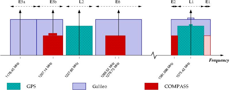
The good news is that all these systems use similar frequencies (sometimes the same frequency, which is a looming problem) so devices should be able to use multiple sat-nav networks to increase accuracy and get a faster fix, just as long as the respective military masters don't hit the kill switch.
In particular, the Galileo and GPS civilian services have been specifically set up so that a single receiver can use both at once.

With the GPS fleet set to drop below 30 in coming years due to funding and technical issues in the States (though not below 24) multi-constellation receivers are likely to become popular as and when Galileo, Beidou and Glonass get up and running for real
Bootnote
*Apart from determining location, a GPS receiver is also an extremely accurate clock: being literally as cheap as chips, it is often used as such and so becomes important for such lesser-known things as keeping cellphone networks running, for instance.
No comments:
Post a Comment