Extracts from a magnificent one hour BBC 2 documentary of Sir Robin Knox-Johnston and Skip Novak, owner of yacht Pelagic, sailing from the Beagle Channel to Cape Horn and then landing on the notorious rock. As crew he takes Sir Ranulph Fiennes and John Simpson.


Expected at Cape Horn on the first day of 2013 Tuesday January 1st, the two Vendée Globe leaders Francois Gabart and Armel Le Cléac’h might be able to look forward to relatively clement, settled weather for their passage but they will have another critical variable set to challenge them as they round the notorious point.

The ice is reckoned to be drifting away at a rate of around 20 miles per day which, suggests Race Director Denis Horeau, means the problem is most serious for the first boats.
Horeau told Vendée Globe LIVE :
“CLS our partner have seen by satellite that there is ice drifting in the south and east of Cape Horn, but of course the problem is that the satellites can only see some of the ice and not all of it. So far we can only see by satellite ice which is at least 100 metres long. And so long as we know that there is ice of 100 metres long approximately then you can be sure that there will be some smaller bergs around. So that is our problem.”
“ The choice is now with the skippers. We will inform them every day of the situation, what we can see with the satellites and what the drift is expected to be. So we will provide them with a report every day in order that they can understand the situation as well as we can see it. The problem is that we cant know the situation exactly.”
“ Putting an ice gate closer to the Cape could only be to the south if it but the ice is drifting to the east at a rate of something like 20 miles per day. So we think most will have passed to the East by the time the majority of skipper are arriving. We hope this problem will only be for the first boats. Putting a gate positioned for the first boats would be unfair for the others. So that is not the way to do it. We make the rules on the Vendée Globe for all the boats.”
“ We had ice in past editions. We have not had this amount of ice at Cape Horn before, we had ice in 2008, but it was to the west of Cape Horn and so we lifted the Pacific East gate north by 400 miles to the north. We had a lot of ice in the east of the Pacific this time. It is difficult to say if it is related to the warming of the planet, but what we do know is that we can see more than before.”

The bergs which are seen by the satellites are between 100m and 400m long, but the problem for the skippers is the smaller sections which almost certainly exist, some of which will be semi-submerged.
By comparison there were significant levels of ice in the East Pacific during the last edition in 2008-9, much of it well before the longitude of Cape Horn
From BYM & Princeton Univ


Cape Horn remains a maritime legend to this day, as sailing around this remote point and then through the Drake Passage was (and is) one of the most challenging nautical routes on the planet.
The violent stretch of chaotic water between Antarctica and South America, one frequented by icebergs, huge waves and plagued by gale-force winds, is crossed by sailors with great trepidation.
Many still prefer to use the sheltered Strait of Magellan.
(photo in high resolution)

The violent stretch of chaotic water between Antarctica and South America, one frequented by icebergs, huge waves and plagued by gale-force winds, is crossed by sailors with great trepidation.
Many still prefer to use the sheltered Strait of Magellan.
(photo in high resolution)
At this spot the Atlantic and Pacific oceans meet, often in a confrontation.
No land to the east, none to the west—winds sweep all the way around the world from the west.
The closest arm of Antarctica, Graham Land of the Antarctic Peninsula, lies six hundred miles to the south across the roughest stretch of water known on the planet, Drake Passage.
Since its discovery by the Dutch mariners Jacob Le Maire and Willem Corneliszoon Schouten in 1616, Cape Horn has become known as the graveyard of ships.


HMS 'Daphne' off Cape Horn, 28 May 1852 (Admiral Edward Gennys Fanshawe)
Its precise geographical location is the southern headland of Horn Island, Chile, in the Tierra del Fuego archipelago at the bottom of South America.
As ships got larger, they could not navigate the Magellan Strait and had to risk “rounding the Horn,” a phrase that has acquired almost mythical status.
For most mariners, it means sailing windward, from the Atlantic to the Pacific, fighting winds, waves, and currents, for sailing with the wind is strategically simpler and carries no bragging rights.


Brian Hancock aboard Alaska Eagle Whitbread Race 81/82
Cape Horn lore is extensive, full of fear and fascination—summed up in the sailor’s motto “below 40 South there is no law, below 50 South there is no God.”
Over the past four hundred years, the Horn’s cold, tempestuous waters have claimed more than one thousand ships and fifteen thousand lives.
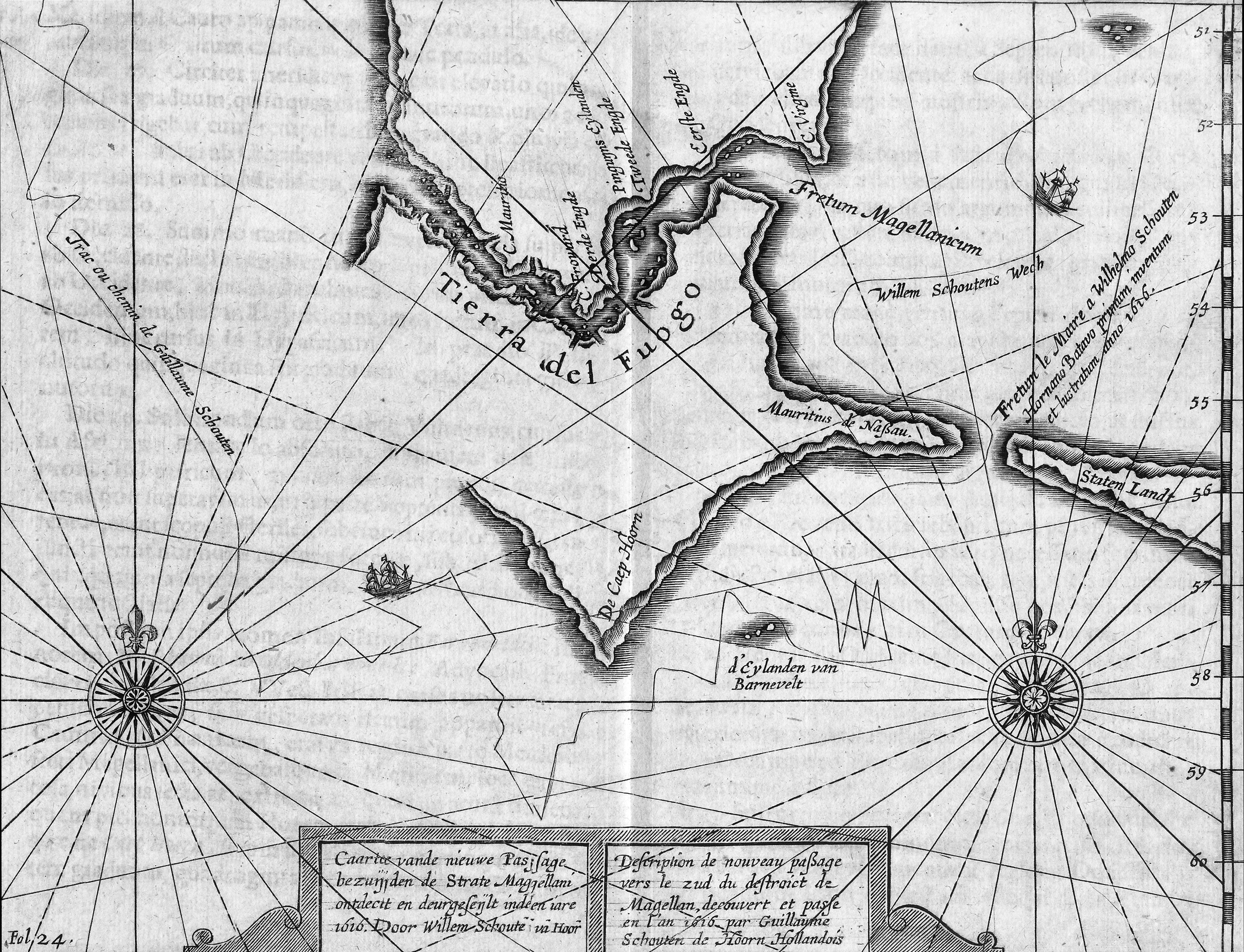
Description of the new route to the South of the Strait of Magellan discovered
and set in the year 1616 by Dutchman Willem Schouten from Hoorn (1619)
and set in the year 1616 by Dutchman Willem Schouten from Hoorn (1619)
Even successful passage has often exacted a toll.
For example, British Admiral George Anson’s 1741 mission to attack Spanish possessions on the west coast of South America took three months to pass Cape Horn; of his six warships, two failed to round the Horn and went home, and one was wrecked on the coast of Chile.

Bounty rounds Cape Horn

Bounty rounds Cape Horn
As we gaze though nature’s sunny smile we see her teeth fully barred ... and, as any sailor will testify ‘to be at the mercy of the sea and to survive is to be born again.’
So is the purpose of this work using warm darks to indicate the infinite depths of the southern ocean - and warm greens show the hopelessness of the situation as the waves rush up to block the light.
(John Hagan's classic 'Bounty' paintings)
(John Hagan's classic 'Bounty' paintings)
Captain William Bligh on the HMS Bounty tried for a month in 1788 to round the Horn on his way to Tahiti, but adverse weather forced him to turn around and take the longer route east past Africa and India instead.
Since the opening of the Panama Canal in 1914, there has been no need for most commercial ships to run the risk anymore, though adventuring sailors and yacht racing enthusiasts continue to test their luck.

zoom view with SHN chart
Cape Horn, Spanish Cabo de Hornos, steep rocky headland on Hornos Island, Tierra del Fuego Archipelago, southern Chile.
Located off the southern tip of mainland South America, it was named Hoorn for the birthplace of the Dutch navigator Willem Corneliszoon Schouten, who rounded it in 1616.
False Cape Horn (Falso Cabo de Hornos), on Hoste Island, 35 miles (56 km) northwest, is sometimes mistaken for it.
Navigation in the rough waters around the cape is hazardous, with a windy and cold year-round climate.

 Cabo de Hornos (SHOA detail map)
Cape Horn, Spanish Cabo de Hornos, steep rocky headland on Hornos Island, Tierra del Fuego Archipelago, southern Chile.
Located off the southern tip of mainland South America, it was named Hoorn for the birthplace of the Dutch navigator Willem Corneliszoon Schouten, who rounded it in 1616.
False Cape Horn (Falso Cabo de Hornos), on Hoste Island, 35 miles (56 km) northwest, is sometimes mistaken for it.
Navigation in the rough waters around the cape is hazardous, with a windy and cold year-round climate.


The lighthouse and sculpture viewed from the south - ie,e while rounding the Horn
(photo GrahamAndDairne)
In 1992, on a hilltop at the East of Horn Island, a monument to the memory of the mariners lost in the waters off Cape Horn was erected, financed with both public and private funds from Chile and many other countries.
The interior outline of its facing steel sheets form the image of a wandering albatross in flight; a nearby marble plaque is inscribed with a Spanish poem by Chilean Sara Vial
 Routes between Strait of Magellan (Estrecho de Magallanes) and Cabo de Hornos
(source Directmar)
(photo GrahamAndDairne)
In 1992, on a hilltop at the East of Horn Island, a monument to the memory of the mariners lost in the waters off Cape Horn was erected, financed with both public and private funds from Chile and many other countries.
The interior outline of its facing steel sheets form the image of a wandering albatross in flight; a nearby marble plaque is inscribed with a Spanish poem by Chilean Sara Vial

(source Directmar)
Ice has been monitored well to the north and east of Drake’s Passage for much of December.
When the leaders are due to round there are expected to be 15 relatively small icebergs to the south and east of Cape Horn at a radius of about 50 miles.

When the leaders are due to round there are expected to be 15 relatively small icebergs to the south and east of Cape Horn at a radius of about 50 miles.

NGA 29002 (Antarctic Peninsula)
Is Cabo de Hornos the southernmost point of South America?
No, the – Islas Diego Ramirez – approx. 60 miles southwest of Cape Horn,
is the southernmost point of South America.
>>> geolocalization with the Marine GeoGarage <<<
The southernmost point of the mainland lays several hundreds of miles north,
on the peninsula Brunswick, near Punta Arenas.
Expected at Cape Horn on the first day of 2013 Tuesday January 1st, the two Vendée Globe leaders Francois Gabart and Armel Le Cléac’h might be able to look forward to relatively clement, settled weather for their passage but they will have another critical variable set to challenge them as they round the notorious point.

The ice is reckoned to be drifting away at a rate of around 20 miles per day which, suggests Race Director Denis Horeau, means the problem is most serious for the first boats.
Horeau told Vendée Globe LIVE :
“CLS our partner have seen by satellite that there is ice drifting in the south and east of Cape Horn, but of course the problem is that the satellites can only see some of the ice and not all of it. So far we can only see by satellite ice which is at least 100 metres long. And so long as we know that there is ice of 100 metres long approximately then you can be sure that there will be some smaller bergs around. So that is our problem.”
“ The choice is now with the skippers. We will inform them every day of the situation, what we can see with the satellites and what the drift is expected to be. So we will provide them with a report every day in order that they can understand the situation as well as we can see it. The problem is that we cant know the situation exactly.”
“ Putting an ice gate closer to the Cape could only be to the south if it but the ice is drifting to the east at a rate of something like 20 miles per day. So we think most will have passed to the East by the time the majority of skipper are arriving. We hope this problem will only be for the first boats. Putting a gate positioned for the first boats would be unfair for the others. So that is not the way to do it. We make the rules on the Vendée Globe for all the boats.”
“ We had ice in past editions. We have not had this amount of ice at Cape Horn before, we had ice in 2008, but it was to the west of Cape Horn and so we lifted the Pacific East gate north by 400 miles to the north. We had a lot of ice in the east of the Pacific this time. It is difficult to say if it is related to the warming of the planet, but what we do know is that we can see more than before.”

Photo courtesy of the Chilean Navy showing a drifting iceberg than 200 meters in diameter and ten feet high about 300 kilometers from Puerto Williams, in Cape Horn.
EFE / Armada de Chile (30 Nov 2012)
The bergs which are seen by the satellites are between 100m and 400m long, but the problem for the skippers is the smaller sections which almost certainly exist, some of which will be semi-submerged.
By comparison there were significant levels of ice in the East Pacific during the last edition in 2008-9, much of it well before the longitude of Cape Horn
Then, the Pacific East gate was moved more than 400 miles to the north to keep the fleet as clear of danger as possible.
Links :
Links :
- Global Security : Rounding Cape Horn
No comments:
Post a Comment