Saturday, January 17, 2015

Between home


Artist and amateur sailor, Nick Jaffe, has been living in Berlin and has decided to take the long way home to Australia, sailing his 1972 Contessa 26.
Some call it brave, others think it’s crazy, but Nick decides to sail solo from the UK to Australia, negotiating the treacherous waters of the Pacific and Atlantic Oceans.
The camera onboard his boat is often Nick’s only companion on a trip that ends up taking over two years.
It captures his reflective musings, his joyful excitement and his isolated struggles in this unique, poetic adventure documentary.
Both the freedom and the fragility of cutting oneself from “life issues” has never seemed more powerfully in play as Nick turns his camera out to the ocean with an endless empty horizon in each and every direction.

Friday, January 16, 2015

Governing the high seas : in deep water

Humans are damaging the high seas.
Now the oceans are doing harm back

From Business Insider UK originally appeared at The Economist

About 3 billion people live within 100 miles (160km) of the sea, a number that could double in the next decade as humans flock to coastal cities like gulls.
The oceans produce $3 trillion of goods and services each year and untold value for the Earth’s ecology.
Life could not exist without these vast water reserves—and, if anything, they are becoming even more important to humans than before.

Mining is about to begin under the seabed in the high seas—the regions outside the exclusive economic zones administered by coastal and island nations, which stretch 200 nautical miles (370km) offshore.
Nineteen exploratory licences have been issued.
New summer shipping lanes are opening across the Arctic Ocean.
The genetic resources of marine life promise a pharmaceutical bonanza: the number of patents has been rising at 12% a year.
One study found that genetic material from the seas is a hundred times more likely to have anti-cancer properties than that from terrestrial life.

But these developments are minor compared with vaster forces reshaping the Earth, both on land and at sea.
It has long been clear that people are damaging the oceans—witness the melting of the Arctic ice in summer, the spread of oxygen-starved dead zones and the death of coral reefs.
Now, the consequences of that damage are starting to be felt onshore.

Thailand provides a vivid example.
In the 1990s it cleared coastal mangrove swamps to set up shrimp farms.
Ocean storm surges in 2011, no longer cushioned by the mangroves, rushed in to flood the country’s industrial heartland, causing billions of dollars of damage.


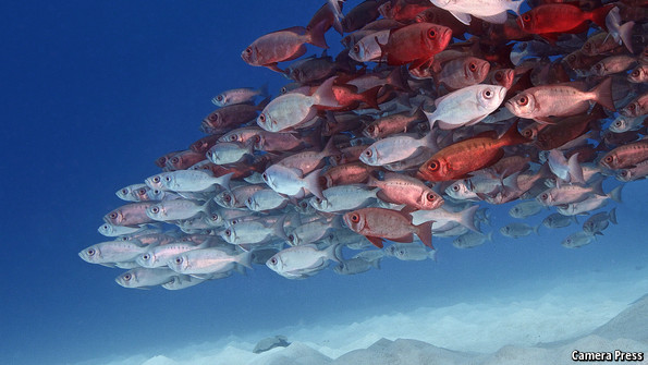
More serious is the global mismanagement of fish stocks.
About 3 billion people get a fifth of their protein from fish, making it a more important protein source than beef.
But a vicious cycle has developed as fish stocks decline and fishermen race to grab what they can of the remainder.
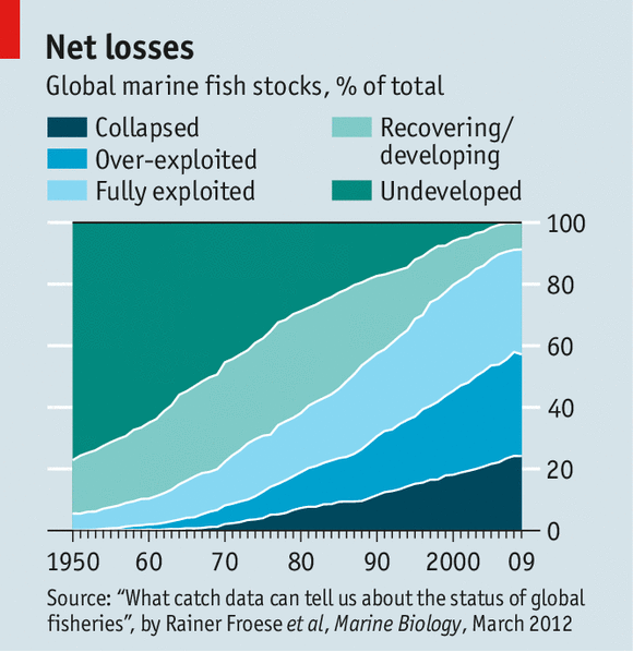
According to the Food and Agriculture Organisation (FAO), a third of fish stocks in the oceans are over-exploited; some estimates say the proportion is more than half (see chart).
One study suggested that stocks of big predatory species—such as tuna, swordfish and marlin—may have fallen by as much as 90% since the 1950s.
People could be eating much better, were fishing stocks properly managed.

The forests are often called the lungs of the Earth, but the description better fits the oceans.
They produce half the world’s supply of oxygen, mostly through photosynthesis by aquatic algae and other organisms.
But according to a forthcoming report by the Intergovernmental Panel on Climate Change (IPCC; the group of scientists who advise governments on global warming), concentrations of chlorophyll (which helps makes oxygen) have fallen by 9-12% in 1998-2010 in the North Pacific, Indian and North Atlantic Oceans.

Climate change may be the reason.
At the moment, the oceans are moderating the impact of global warming—though that may not last (see article).
Warm water rises, so an increase in sea temperatures tends to separate cold and warm water into more distinct layers, with shallower mixed layers in between.
That seems to lower the quantity of nutrients available for aquatic algae, and to lead to decreased chlorophyll concentrations.
Changes in the oceans, therefore, may mean less oxygen will be produced.
This cannot be good news, though scientists are still debating the likely consequences.
The world is not about to suffocate.
But the result could be lower oxygen concentrations in the oceans and changes to the climate because the counterpart of less oxygen is more carbon—adding to the build-up of greenhouse gases.
In short, the decades of damage wreaked on the oceans are now damaging the terrestrial environment.


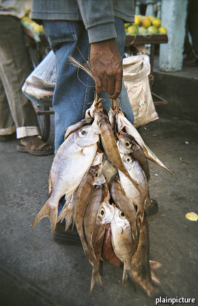
A fisherman walks towards his boat in Khao Lak, Phang Nga province . His way of life, along with

A tragedy foretold

The oceans exemplify the “tragedy of the commons”—the depletion of commonly held property by individual users, who harm their own long-term interests as a result.
For decades scientists warned that the European Union’s fishing quotas were too high, and for decades fishing lobbyists persuaded politicians to ignore them.
Now what everyone knew would happen has happened: three-quarters of the fish stocks in European waters are over-exploited and some are close to collapse.

The salient feature of such a tragedy is that the full cost of damaging the system is not borne by those doing the damage.
This is most obvious in fishing, but goes further. Invasive species of many kinds are moved around the world by human activity—and do an estimated $100 billion of damage to oceans each year.
Farmers dump excess fertiliser into rivers, which finds its way to the sea; there cyanobacteria (blue-green algae) feed on the nutrients, proliferate madly and reduce oxygen levels, asphyxiating all sea creatures. In 2008, there were over 400 “dead zones” in the oceans.
Polluters pump out carbon dioxide, which dissolves in seawater, producing carbonic acid.
That in turn has increased ocean acidity by over a quarter since the start of the Industrial Revolution. In 2012, scientists found pteropods (a kind of sea snail) in the Southern Ocean with partially dissolved shells.

It is sometimes possible to preserve commons by assigning private property rights over them, thus giving users a bigger stake in their long-term health.
That is being tried in coastal and island nations’ exclusive economic zones.
But it does not apply on the high seas.
Under international law, fishing there is open to all and minerals count as “the common heritage of mankind”.
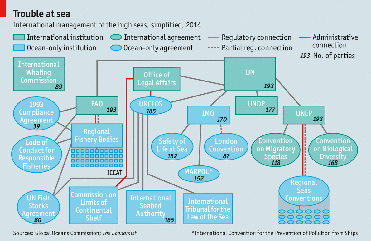
Here, a mishmash of international rules and institutions determines the condition of the watery commons.

The high seas are not ungoverned.
Almost every country has ratified the UN Convention on the Law of the Sea (UNCLOS), which, in the words of Tommy Koh, president of UNCLOS in the 1980s, is “a constitution for the oceans”.
It sets rules for everything from military activities and territorial disputes (like those in the South China Sea) to shipping, deep-sea mining and fishing.
Although it came into force only in 1994, it embodies centuries-old customary laws, including the freedom of the seas, which says the high seas are open to all.
UNCLOS took decades to negotiate and is sacrosanct.
Even America, which refuses to sign it, abides by its provisions.

But UNCLOS has significant faults.
It is weak on conservation and the environment, since most of it was negotiated in the 1970s when these topics were barely considered.
It has no powers to enforce or punish.
America’s refusal to sign makes the problem worse: although it behaves in accordance with UNCLOS, it is reluctant to push others to do likewise.

Alphabet bouillabaisse


Specialised bodies have been set up to oversee a few parts of the treaty, such as the International Seabed Authority, which regulates mining beneath the high seas.
But for the most part UNCLOS relies on member countries and existing organisations for monitoring and enforcement.
The result is a baffling tangle of overlapping authorities (see diagram) that is described by the Global Ocean Commission, a new high-level lobby group, as a “co-ordinated catastrophe”.

Individually, some of the institutions work well enough.
The International Maritime Organisation, which regulates global shipping, keeps a register of merchant and passenger vessels, which must carry identification numbers.
The result is a reasonably law-abiding global industry.
It is also responsible for one of the rare success stories of recent decades, the standards applying to routine and accidental discharges of pollution from ships.
But even it is flawed.
The Institute for Advanced Sustainability Studies, a German think-tank, rates it as the least transparent international organisation.
And it is dominated by insiders: contributions, and therefore influence, are weighted by tonnage.

Other institutions look good on paper but are untested.
This is the case with the seabed authority, which has drawn up a global regime for deep-sea mining that is more up-to-date than most national mining codes.
For once, therefore, countries have settled the rules before an activity gets under way, rather than trying to catch up when the damage starts, as happened with fishing.

The problem here is political rather than regulatory: how should mining revenues be distributed? Deep-sea minerals are supposed to be “the common heritage of mankind”.
Does that mean everyone is entitled to a part?
And how to share it out?

The biggest failure, though, is in the regulation of fishing.
Overfishing does more damage to the oceans than all other human activities there put together.
In theory, high-seas fishing is overseen by an array of regional bodies.
Some cover individual species, such as the International Commission for the Conservation of Atlantic Tunas (ICCAT, also known as the International Conspiracy to Catch All Tuna).
Others cover fishing in a particular area, such as the north-east Atlantic or the South Pacific Oceans. They decide what sort of fishing gear may be used, set limits on the quantity of fish that can be caught and how many ships are allowed in an area, and so on.

Here, too, there have been successes.
Stocks of north-east Arctic cod are now the highest of any cod species and the highest they have been since 1945—even though the permitted catch is also at record levels.
This proves it is possible to have healthy stocks and a healthy fishing industry.
But it is a bilateral, not an international, achievement: only Norway and Russia capture these fish and they jointly follow scientists’ advice about how much to take.

There has also been some progress in controlling the sort of fishing gear that does the most damage. In 1991 the UN banned drift nets longer than 2.5km (these are nets that hang down from the surface; some were 50km long).
A series of national and regional restrictions in the 2000s placed limits on “bottom trawling” (hoovering up everything on the seabed)—which most people at the time thought unachievable.

But the overall record is disastrous.
Two-thirds of fish stocks on the high seas are over-exploited—twice as much as in parts of oceans under national jurisdiction.
Illegal and unreported fishing is worth $10 billion-24 billion a year—about a quarter of the total catch.
According to the World Bank, the mismanagement of fisheries costs $50 billion or more a year, meaning that the fishing industry would reap at least that much in efficiency gains if it were properly managed.

Most regional fishery bodies have too little money to combat illegal fishermen.
They do not know how many vessels are in their waters because there is no global register of fishing boats.
Their rules only bind their members; outsiders can break them with impunity.
An expert review of ICCAT, the tuna commission, ordered by the organisation itself concluded that it was “an international disgrace”.
A survey by the FAO found that over half the countries reporting on surveillance and enforcement on the high seas said they could not control vessels sailing under their flags.
Even if they wanted to, then, it is not clear that regional fishery bodies or individual countries could make much difference.

But it is far from clear that many really want to.
Almost all are dominated by fishing interests.
The exceptions are the organisation for Antarctica, where scientific researchers are influential, and the International Whaling Commission, which admitted environmentalists early on.
Not by coincidence, these are the two that have taken conservation most seriously.

A dwindling catch

Empty promises

Countries could do more to stop vessels suspected of illegal fishing from docking in their harbours—but they don’t.
The FAO’s attempt to set up a voluntary register of high-seas fishing boats has been becalmed for years.
The UN has a fish-stocks agreement that imposes stricter demands than regional fishery bodies. It requires signatories to impose tough sanctions on ships that break the rules.
But only 80 countries have ratified it, compared with the 165 parties to UNCLOS.
One study found that 28 nations, which together account for 40% of the world’s catch, are failing to meet most of the requirements of an FAO code of conduct which they have signed up to.

It is not merely that particular institutions are weak.
The system itself is dysfunctional.
There are organisations for fishing, mining and shipping, but none for the oceans as a whole. Regional seas organisations, whose main responsibility is to cut pollution, generally do not cover the same areas as regional fishery bodies, and the two rarely work well together.
(In the north-east Atlantic, the one case where the boundaries coincide, they have done a lot.)
Dozens of organisations play some role in the oceans (including 16 in the UN alone) but the outfit that is supposed to co-ordinate them, called UN-Oceans, is an ad-hoc body without oversight authority.
There are no proper arrangements for monitoring, assessing or reporting on how the various organisations are doing—and no one to tell them if they are failing.

Pressure for change is finally building up. According to David Miliband, a former British foreign secretary who is now co-chairman of the Global Ocean Commission, the current mess is a “terrible betrayal” of current and future generations.
“We need a new approach to the economics and governance of the high seas,” he says.

That could take different forms.
Environmentalists want a moratorium on overfished stocks, which on the high seas would mean most of them.
They also want regional bodies to demand impact assessments before issuing fishing licenses.
The UN Development Program says rich countries should switch some of the staggering $35 billion a year they spend subsidizing fishing on the high seas (through things like cheap fuel and vessel-buy-back programs) to creating marine reserves—protected areas like national parks.

A scuba diver takes pictures of a turtle close to Wolf Island at Galapagos Marine Reserve.

Others focus on institutional reform.
The European Union and 77 developing countries want an “implementing agreement” to strengthen the environmental and conservation provisions of UNCLOS.
They had hoped to start what will doubtless be lengthy negotiations at a UN conference in Rio de Janeiro in 2012. But opposition from Russia and America forced a postponement; talks are now supposed to start by August 2015.

Still others say that efforts should be concentrated on improving the regional bodies, by giving them more money, greater enforcement powers and mandates that include the overall health of their bits of the ocean.
The German Advisory Council on Global Change, a think-tank set up by the government, argues for an entirely new UN body, a World Oceans Organization, which it hopes would increase awareness of ocean mismanagement among governments, and simplify and streamline the current organizational tangle.

According to Elinor Ostrom, who won the Nobel prize for economics in 2009, to avoid a tragedy of the commons requires giving everyone entitled to use them a say in running them; setting clear boundaries to keep out those who are not entitled; appointing monitors who are trusted by users; and having straightforward mechanisms to resolve conflicts.
At the moment, the governance of the high seas meets none of those criteria.

Changes to high-seas management would still do nothing for two of the worst problems, both caused on land: acidification and pollution.
But they are the best and perhaps only hope of improving the condition of half of the Earth’s surface.

Links :
  • NYTimes : Ocean life faces mass extinction, broad study says

Thursday, January 15, 2015

Marine GeoGarage nautical charts platform accessible for Weather 4D Pro Android mobile app users


The partnership between the Marine GeoGarage and Weather 4D, developer of Weather 4D Pro, shown for the first time at the Paris Boat Show last month, starts adding raster nautical maps (RNCs) in this amazing weather application for sailors.

Weather4D Pro provides innovative viewing of weather plus optimized routing for sailing boats.
The app's intuitive interface makes it easy to get the latest weather for your area
and see predictions up to 8 days out.

Weather4D is the first application to animate the weather like a video.
2D or 3D display is complemented by the continuous scrolling of time which allows to perfectly visualize the evolution of weather phenomena to come.

So users of the W4D Android app for compatible smartphones & tablets can now benefit from the Marine GeoGarage raster charts online platform, with RNCs (Raster Nautical Charts) issued from official material coming from diffrent international Hydrographic Offices and regularly updated on the GeoGarage Cloud computing solution.

Optional GeoGarage online nautical charts access additionally to
Blue Marble, Open Street Map & Bing (maps & satellite)

Through some App-in purchase possibility, the user subscribes to a yearly access to one or several nautical charts layer :
  • USA (NOAA RNCs)
  • UK & miscellaneous countries which have signed bilateral agreement with UKHO for their charts distribution (Spain, Portugal, Croatia, Belgium, Iceland, Malta, Oman, South Africa)
  • France (SHOM RNCs)
  • Canada (CHS RNCs)
  • Australia (CHS RNCs)
  • New Zealand (Linz RNCs)
  • Brazil (DHN RNCs)
  • Argentina (SHN RNCs)
  • Netherlands (NLHO RNCs)
  • Germany (BSH RNCs)
  • Bahamas (WLP RNCs) 
Nautical charts on a 3D Globe
offering continuous chart display with seamless quilting at unparalleled speed 
via the pinch to zoom-in/out feature


Note : the access to the Marine GeoGarage nautical charts layer would be available in the next months for iPhone/iPad Weather 4D users on the AppStore


W4DAndroidNautic (French demo)

Tropical paradise inspires virtual ecology lab

 Digital version of Moorea will provide a way to experiment with an entire ecosystem.
photo Yann Arthus-Bertrand (Corbis)

From Nature by Daniel Cressey

A paradise on Earth could soon become the first ecosystem in the world to be replicated in digital form in pain­staking detail, from the genes of its plants and animals to the geography of its landscape.

An international team is preparing to create a digital avatar of the Pacific island of Moorea, which lies off the coast of Tahiti and is part of French Polynesia.
Moorea is already one of the most studied islands in the world; the team plans to turn those data into a virtual lab that would allow scientists to test and generate hypotheses about the impact of human activities.


Mooréa with the Marine GeoGraage (SHOM chart)

Ecologists have used models for years to tease out the relationships between different facets of nature, such as temperature and population or predators and prey.
But much of that modelling is relevant only to specific species or research questions, and some scientists want a holistic view.
As human activity and natural variations combine to alter the environment, researchers need to know how mitigating steps — such as setting up protected areas, or attempts to curb fossil-fuel use — might affect an entire ecosystem.

“We know the world’s changing. Yet the decisions we’re making, we’re making them in the dark,” says Neil Davies, one of the people behind the Moorea IDEA (Island Digital Ecosystem Avatars) project and director of Gump Station, the University of California, Berkeley’s marine-science base on the island.
“We’re not going to have precise predictions ever, but we need to have a way of modelling different scenarios.”
For example, if a hotel is built at a certain location, how does that change the ecosystem?
If a species disappears from a river, what happens downstream?

Moorea is an ideal place to start, says Davies, because the island is about 16 kilometres across and has just 17,000 people living on it, making it easier to model than larger ecosystems and those that are more connected to the rest of the world.
In addition, French researchers have been there since the 1970s, and Gump Station has been operating since the 1980s.
Both efforts have collected myriad data on the island’s waters, with decades-long studies of coral and fish numbers (see ‘Data heaven’).


 The Moorea Biocode Project is a library of genetic markers and digital identifiers for every species of animal, plant, and fungus on the island of Moorea.
This first comprehensive inventory of all non-microbial life in a complex tropical ecosystem will provide a unique platform for the international research 

These traditional surveys of marine life are now being linked up with the Moorea Biocode Project, which aims to characterize every species larger than a millimetre in length on the island and allocate them a ‘DNA barcode’ — snippets of DNA that can be used as a unique identifier.
Species can thus be identified quickly and easily even when they are in places or states that would otherwise be difficult to recognize, such as in the contents of another organism’s stomach, or in seed or larval form.

The avatar would combine insights gleaned from the Biocode project — such as which species are present at certain ocean spots, or which species are eaten by another — with data on weather, ocean currents and society such as population density and real-estate prices.
It would provide a three-dimensional visualization of the island and its surrounding waters that might look something like those on Google Earth, but would enable researchers to zoom into a location, access data and run simulations.

“The first stage will be a framework to integrate the data we have. To collate them, combine them, and to make the data accessible to scientists,” says project member Matthias Troyer, a computer scientist at the Swiss Federal Institute of Technology in Zurich.
“Then, based on that, one can start on modelling.”

Copyright David Littschwager/National Geographic

Expanding project

The IDEA project was born in 2013, the brainchild of Davies, Troyer and three other marine scientists: Dawn Field at the University of Oxford, UK; Sally Holbrook at the University of California, Santa Barbara; and Serge Planes from the French research base on Moorea.
The consortium now has more than 80 participants.

At meetings late last year, the IDEA team discussed how to combine existing data with those coming from the latest technologies.
Some of the framework for the avatar is already under construction, and Davies says that the team is seeking funding of around US$5 million over three years to pursue a pilot project.

The project is “really novel in the modelling community”, says Mike Harfoot, an ecosystem modeller at the United Nations Environment Programme’s World Conservation Monitoring Centre in Cambridge, UK, because it will integrate societal data with physical and biological components.
And, he adds, the computational power required to take a holistic approach to modelling ecosystems has only recently become available.

“It’s impressive the amount of data that’s going in it,” says Rick Stafford, a computational ecologist at Bournemouth University, UK.
Getting the different data sets to talk to each other will be a challenge, but the time is ripe for such an ambitious undertaking, says Davies.
And it if works on Moorea, the approach could be rolled out to other parts of the world.
Although ambitious, says Davies, “it’s not a pipe dream”.

Wednesday, January 14, 2015

NZ Linz update in the Marine GeoGarage

Coverage NZ Linz Marine GeoGarage layer

As our public viewer is not yet available
(currently under construction, upgrading to a new webmapping technology as Google Maps v2 is officially no more supported),
this info is primarily intended to
our universal mobile application users
(Marine NZ iPhone-iPad on the Apple Store/ Weather 4D Android -App-in- on the PlayStore)
and our B2B customers which use our nautical charts layers
in their own webmapping applications through our GeoGarage API.  


7 charts has been updated in the Marine GeoGarage
(Linz December update published January 9, 2015 (Updated to NTM Edition 26, 26 December 2014)

  • NZ531 Great Barrier Island (Aotea Island) to Mercury Bay
  • NZ534 Mercury Bay to Katikati Entrance
  • NZ845 Niue
  • NZ4633 Wellington Harbour
  • NZ4634 Wellington Harbour Entrance and Plans of Wharves
  • NZ14630 INT 630 Samoa Islands to Southern Cook Islands
  • NZ14631 INT 631 Samoa Islands to Tonga including Niue
Today NZ Linz charts (183 charts / 323 including sub-charts) are displayed in the Marine GeoGarage.

Note :  LINZ produces official nautical charts to aid safe navigation in New Zealand waters and certain areas of Antarctica and the South-West Pacific.


Using charts safely involves keeping them up-to-date using Notices to Mariners
Reporting a Hazard to Navigation - H Note :
Mariners are requested to advise the New Zealand Hydrographic Authority at LINZ of the discovery of new or suspected dangers to navigation, or shortcomings in charts or publications.

Ocean exploration benefits NOAA and the nation


Consider that we have explored only five percent of our ocean,
meaning that 95 percent of what lies beneath remains unknown.
The NOAA Office of Ocean Exploration and Research is the only federal organization currently dedicated to exploring our unknown ocean.
From our skilled staff to our tools and technologies and our ability to deliver data accurately and fast, our unique capabilities are helping to advance knowledge and understanding needed to help citizens, businesses, and governments make smart choices to protect lives, property, and economic wellbeing.
There's a lot of exploration left to do...who's with us?!

From NOAA by Alan P. Leonardi

Fiscal year 2014 continued a tradition of excitement and productivity for NOAA’s Office of Ocean Exploration and Research (OER).
It was a year of accomplishments that advanced our understanding of the ocean.
In my view, there are several ocean exploration matters of particular importance.
First, we have a national need to explore the ocean.
NOAA is often described as the nation’s “environmental intelligence agency,” and exploration is the vital first step in gathering ocean intelligence.
OER is the only federal organization systematically exploring our largely unknown ocean for the purpose of discovery and the advancement of knowledge.
Despite the fact that it covers 71 percent of our planet’s surface and supports countless forms of life in and out of the water, much of Earth’s ocean remains unexplored.

Second, we acknowledge that OER’s exploration record is studded with accomplishments.
Those accomplishments are recorded in this and past annual reports, on our website, and in scientific journal articles based in whole or in part on OER expeditions and projects.

  NOAA Ship Okeanos Explorer: Gulf of Mexico 2012, Spectacular New Shipwreck Discovery

They reflect the leadership, expertise, and hard work of the OER team, but also the shared knowledge, planning, funding, equipment, technology, and staffing of our many valued partnerships, including other NOAA offices, federal, regional and state agencies, educational and oceanic institutions, industry, and not-for-profits.
Exploring deep-ocean frontiers is too expensive and challenging for any single organization, and partnerships move us all forward with a sense of collaboration and community.

Third, we must always consider the value of ocean exploration and our accountability to a critical stakeholder: the taxpayer.
With our partners, NOAA’s ocean exploration team acquires and shares crucial data that benefits science and the economy by enabling policymakers and resource managers to make informed decisions about how to best use and protect the ocean and all it contains.

With each technology advanced and expedition undertaken, OER fills in knowledge gaps about deep-ocean areas, stimulates research and new lines of scientific inquiry, and provides high-value environmental ocean intelligence not available elsewhere but needed to address both current and emerging needs.
These are the returns on investments OER provides to taxpayers.

 Know your ocean

I begin my tenure as OER’s new director firmly believing in the vital importance of our work.
This report chronicles work that OER and our partners have accomplished together, for the great benefit of NOAA and the nation.
We also recognize that much work and discovery still lie ahead.
Our future will be filled with new and continued partnerships and advancements in obtaining and sharing information.
This includes the possibility of using telepresence in new ways to allow scientists ashore to participate virtually in research at sea.

OER is well known as a reliable partner and source of knowledge, yet it also thrives on incremental and transformational change, improvement, and innovation.
This balance allows us to sail toward a future bright with potential, and I look forward to bringing you news of our progress in 2015.

Links :

Tuesday, January 13, 2015

Does metal found in a 2,600-year-old shipwreck prove that Atlantis DID exist? Mythical red alloy said to be from the lost island is discovered off coast of Sicily

The shipwreck with the ingots was found 1,000 feet
off shore of the town of Gela in the sourthern part of Sicily
Gela with the Marine GeoGarage

From TheDailyMail by Richard Gray
  • Marine archaeologists found 39 ingots of 'orichalcum' off the town of Gela
  • They were discovered on the sandy sea floor in a wreck under 10ft of water
  • Experts say they are the mythical metal Plato claimed was from Atlantis
  • Analysis has shown they are an alloy of copper, zinc, lead, iron and nickel
  • Shipwreck is a 2,600 year old cargo vessel thought to be from Greece
  • Researchers believe it was sunk in a storm just 1,000 feet from shore
A mythical metal said by ancient Greeks to be found in the lost city of Atlantis has been recovered from a ship that sunk 2,600 years ago off the coast of Sicily.
Marine archaeologists found 39 ingots of what they believe is 'orichalcum' on the sandy seabed among the wreck of a trading vessel that sank 1,000 feet off the coast of the town of Gela, in southern Sicily.
The wreck is the fifth ancient ship to be recovered off the coast of the town.

One of the lumps of 'orichalcum' that was found on the seabed just off the coast of Gela, in southern Sicily
The metal found on the sea floor off Sicily (above) was found to be an alloy of copper, zinc, lead, nickle and iron

Professor Sebastiano Tusa, an archaeologist at the office of the Superintendent of the Sea in Sicily, claimed the metal they had discovered in the remains of the ship was probably the mythical and highly prized red metal orichalcum.
Analysis of the metal ingots revealed they were made from an alloy of copper and zinc with traces of nickel, lead and iron.
Professor Tusa told the Mail Online that the X-ray fluorescent analysis of the metal had confirmed that it was orichalcum.
He said: 'The discovery is unique and exceptional because it is the fist time that we find oricalcum ingots.'
Speaking to Discovery News, he added: 'Nothing similar has ever been found.
'We knew orichalcum from ancient texts and a few ornamental objects.
'The wreck dates to the first half of the sixth century.
'It was found about 1,000 feet from Gela's coast at a depth of 10 feet.'
If the metal discovered by Professor Tusa and his team is really the mythical orichalcum, then it lends support to the idea of Atlantis as being a real place.

 Statues like this one above from the sunken Egyptian city of Heracleion have recently been rediscovered by marine archaeologists, raising hopes that if Atlantis did ever exist then it may still be found under the sea

The existence of the island is greatly debated among historians and archaeologists.
Some believe it is entirely fictional while others claim stories of the 'Island of Atlas' may have been based on a real historical location that was drowned by rising sea levels or a tsunami.
The Egyptian city of Heracleion, for example, was lost 1,200 years ago when it was engulfed by the sea.
Most of the legend of Atlantis comes from the work of the Greek philosopher Plato, who describes how the great nation was submerged beneath the Atlantic Ocean after falling out of favour with the Gods.
Plato mentions orichalcum in the Critias dialogue and describes Atlantis as flashing with the 'red light' of the metal.
He wrote that orichalcum was highly prized and second only in value to gold. It was mined in the mythical island and covered the surfaces of Poseidon's temple.
The existence of this metal and its composition has since been widely debated, but it is commonly thought to be a brass-like alloy. Brass is made from copper and zinc.
It is thought to have been made through a process called cementation, which reacts zinc ore with charcoal and copper in a crucible.

This map of Atlantis - oriented with south at the top - was drawn by 17th century scholar Athanasius Kircher, who pinpointed the mythical continent as being in the mid-Atlantic before it was lost to the sea

X-ray fluorescence of the ingots found off the coast of Gela show they were made from 75-80 per cent copper, 15-20 per cent zinc and small amounts of nickel, lead and iron.
Professor Tusa told the Mail Online: 'The shipwreck is dated to the beginning of 6th century BC.
'We cannot say how big is the vessel because we have to dig into the sand to recover what it is left of the wooden hull. But I presume that she was about 15 metres (49 feet) long.
'It is a new shipwreck unknown before this discovery.'
'She was sailing to Gela and was entering the harbor situated at the mouth of river Gela.
'Probably during the entrance there was some mistake in the maneuvering because of heavy sea and the ship went into the sandy beach'
Professor Tusa said that they also found some Greek vases, a terracotta figure of the Goddess Demeter and some wood in the wreck.
He added: 'The finding confirms that about a century after its foundation in 689BC, Gela grew to become a wealthy city with artisan workshops specialised in the production of prized artifacts.'

Monday, January 12, 2015

Putin makes his first move in race to control the Arctic

Northern Fleet: Vladimir Putin rides in a submersible vessel in the Baltic Sea as Russia announces the resumption of its presence in the Arctic, a project that had been abandoned by the military after the fall of the USSR.

From Newsweek by Elisabeth Braw

In November, the Russian K-550 nuclear ballistic submarine Alexander Nevsky, submerged in the Barents Sea between Russia and the North Pole, successfully launched a missile that travelled its prescribed course to Kamchatka in Russia’s far east.
The Alexander Nevsky thus joins two other Russian nuclear submarines, which have, in the course of the autumn, conducted successful ballistic missile tests.

Russian nuclear submarines have long been based in Arctic waters, just as the United States keeps its fleet in the Atlantic and Pacific oceans.
Still, the missile tests from the icy region sent a chilly message.
The Alexander Nevsky and its brothers – the Vladimir Monomakh and the Yuri Dolgorukiy – belong to Russia’s new Borei-class nuclear submarine fleet, which can carry up to 20 of the country’s new Bulava nuclear missiles.
With its payload of 10 nuclear warheads capable of travelling up to 8,000 kilometres – the distance between, say, Moscow and Chicago – the Bulava is a fearsome weapon.
“Because of the Ukrainian situation, the West is reluctant to take into account that Russia is a nuclear power that’s investing heavily in its nuclear arsenal,” says Pavel Baev, a professor at the Peace Research Institute in Oslo and a former researcher at the then-Soviet Ministry of Defence.
Mighty though they may be, the Borei-class submarines aren’t much larger than the ageing vessels they’re replacing.
“You could argue that a few new nuclear submarines don’t make a difference,” says Baev.
“But Putin is engaging in nuclear brinksmanship. It’s a dangerous game that the West is reluctant to get involved in, and he seems to be betting that that will give him the upper hand.”
Though all five official nuclear weapons states – United States, Russia, France, Britain, China – are modernising their arsenals, Russia’s overhaul of its vast Soviet-era range is particularly ambitious.

 Cape Schmidt with the Marine GeoGarage

Nuclear brinksmanship aside, the military giant has embarked on a mission to leave footprints in the Arctic.
In October, defence minister Sergei Shoigu announced that Russia will deploy military units along its entire Arctic coast, “from Murmansk to Chukotka” (a distance of 4,700 kilometres).
The armed forces have begun building military facilities on Cape Schmidt in Russia’s far east and on the country’s Arctic Wrangel Island and Kotelny Island; next year the country is scheduled to open an airport at Cape Schmidt.
Earlier this year it reopened its northern Alakurtti military base near the Finnish border (featuring 3,000 soldiers), and on 1 December president Vladimir Putin announced that Russia’s Arctic command has become operational.

The concept of an Arctic race memorably introduced itself when Russian explorers planted a flag on the Arctic seabed in 2007.
Since then, cooperation has been taking precedence.
“But now the Arctic race is heating up, primarily because of Russia,” notes Baev.
“These sharply-increasing military activities don’t make much sense considering that Ukraine is Russia’s military priority right now, but the Arctic isn’t just Putin’s pet project. The Arctic is the one neighbourhood in the world where Russia feels strong.”
(Russia’s Arctic command did not respond to an interview request.)

It’s also the one neighbourhood in the world that has large untapped energy resources: some 22% of the world’s undiscovered oil and natural gas, according to the US Energy Information Administration.
With climate change making the Arctic ocean’s resources more accessible, energy giants from Statoil to Rosneft are testing the waters.
The melting ice is also making regular shipping more realistic.
Last year 71 ships carrying 1.4 million tonnes of cargo traversed the Arctic northern sea route – which cuts the travelling time from Shanghai to Hamburg by 30% – escorted by Russian icebreakers. “But most international shipping companies don’t favour the Arctic, and China’s massive new container ships can’t get through there,” explains Duncan Depledge, an associate fellow specialising in Arctic geopolitics at the RUSI, a London think tank. Indeed, the 71 Arctic transits pale compared to the 16,596 transits through the Suez canal last year.
But Sweden and Finland, home to regions north of the Arctic circle, are sensing opportunities and have opened Brussels offices promoting industrial development.
Even Poland has launched a GoArctic campaign.

Near the North Pole, as in the Middle East, oil and the military go hand in hand. “In the Arctic, Russia is the undisputed number one,” observes Katarzyna Zysk, an associate professor at the Norwegian Institute for Defence Studies.
“But Norway is trying hard to assert its role, especially since the high north plays a significant role in its economic and defence policy. Denmark and Canada are active too, and interest is increasing in the United States as well. These developments are closely followed by Russia, especially given the current tensions with Nato.”

Yet the reopened military bases may be more peaceful than they seem.
“All activities in the Arctic need some sort of security aspect,” says Depledge.
“In much of the Arctic, the military is the only institution that can perform that constabulary function.” 

Here’s the catch: if one country makes military moves, its competitors respond.
Norway, Russia’s closest Arctic neighbour and home to Nato’s first Arctic military operations centre, has been moving troops and equipment north, and prime minister Erna Solberg recently announced that Arctic concerns have caused the country to keep its fighter jets at home rather than sending them on Isis-fighting missions.
In December, Norway introduced an extremely advanced spy vessel that will patrol its Arctic waters.

Indeed, if a second cold war unfolded, the front line would be not just along the Baltic states but right here in the Arctic, between Norway and Russia.
“Russia’s military actions on the European side of the Arctic worry Denmark as well as other Arctic nations,” reports Rear Admiral Nils Wang, commandant of the Danish Defence College and one of the country’s leading Arctic experts
 “Though its reopened military bases also have a coastguard function, Russia is using them to send a strong message to the world and its own citizens that it will defend its Arctic presence if necessary. But the Arctic resources both off-shore and on-shore have already been allocated to the five Arctic coastal nations, so a conflict in the Arctic would more likely be a spillover from conflicts elsewhere, for example Ukraine.”
Denmark, too, has a new Arctic command, while Canada – long an aspiring Arctic superpower – makes its presence known by regularly dispatching naval vessels carrying Canadian flags and sometimes government ministers. 

 Area of the continental shelf of the Russian Federation in the Arctic Ocean
beyond 200-nautical-mile zone

One third of the Arctic is land; one third icy international waters; and one third shallower waters located on continental shelf.
While international law gives the five Arctic nations exclusive economic zones in the waters off their Arctic coasts, the resource-rich continental shelf has become sought-after international real estate. Recently Russia’s natural resources minister Sergey Donskoy announced that 1.2 square kilometres of hydrocarbon-rich continental shelf should belong to Russia.
The country, Donskoy said, will apply to the UN Commission on the Limits of the Continental Shelf (CLCS) for a continental shelf extension next spring.
(A Russian application submitted to the CLCS in 2001 was rejected due to insufficient evidence.) Last year, Canada filed a similar application with the CLCS, claiming rights to 1.7 million square kilometres of Arctic continental shelf.
And in early December, Denmark submitted a CLCS application asserting that it owns the North Pole itself.

Given that International Energy Agency predicts a 35% rise in global energy demand between 2010 and 2035, the quest for the Arctic makes perfect sense.
“Right now, with global energy prices low, it’s not very profitable to invest in Arctic energy exploration, but as far as Russia is concerned, it will remain interested whatever happens,” explains Zysk.
“The Russians feel that they have to move to the Arctic ocean to secure their energy future, and their military presence protects the country’s economic interests. They’re essentially saying, ‘we’re here’.”

That economic potential could spell doom for the Arctic. According to Greenpeace, “inevitable” oil spills would irreversibly harm the pristine region’s polar bears, seals, whales and fish.
“And who would clean up after an oil spill?” asks the environmental group’s Arctic campaigner Charlie Kronick.
“In the Gulf of Mexico, BP was able to deploy hundreds of ships and thousands of workers, and the Macondo well still released around four million barrels of oil.  Because the Arctic has none of the infrastructure or facilities available in the Gulf of Mexico, an oil spill would provoke an international incident when the oil starts travelling underneath the ice.”

Indeed, in spite of global warming, the northernmost continent on earth remains immensely cold.
As Putin made his Arctic command announcement, thermometers on Kotelny Island recorded -30 degrees Celsius.
“The Russian military’s existing Arctic bases are built Soviet-style and are not really appropriate to live in,” notes the Vladivostok-born Baev
 “Even to reach them during the winter is extremely difficult. Arctic threats to Russia by Nato are negligible; in fact, right now nobody is threatening the troops except Mother Nature.”

That’s the sticking point: there is no real enemy.
As the ice of the Arctic ocean melts, its surrounding countries have a stronger interest in cooperation – or in hydrocarbons and shipping – than in confrontation that will feature sacrifice for uncertain rewards.
And for the time being, the Arctic showdown is mostly a play to the gallery.
“Russia is showing people at home that it’s still a major power, and the Canadian government is playing at threat perceptions to show our power and sovereignty in the Arctic,” says Frédéric Lasserre, a professor at the Université Laval in Quebec who specialises in Arctic geopolitics.
“It’s just a play to get votes.”

Links :

Sunday, January 11, 2015

Depactus: Men of extraordinary pursuits - Mark Healey


A life spent in the sea, Mark Healey's relationship with his aquatic environments is innate.
From tackling giant surf to becoming one with the undersea world,
he is a man of extraordinary pursuits.