Saturday, October 1, 2016

Coral colors

In this video we have tried to show movement and the enormous chromatic beauty of corals, a kind of marine animals that despite being one of the oldest animals on our planet, are mostly unknown.
You will discover its stunning beauty, its spectacular colors and the mystery of his movements.
To capture these images it was necessary to apply the technique of time lapse as the slow movements of these animals are very difficult to see at a glance.
The use of macro lens gives a large enough vision to contemplate the huge variety of colorful species.
To perform this video over 25000
individual images of the marine invertebrates to compose, and photography of species, such as the Acanthophyllia, Trachyphyllia, Heteropsammia cochlea, Physogyra, were made for approximately 1 year.
We like to think that with this work, we have put a small grain of sand to raise your attention about the Great Barrier Reef, one of the natural wonders of our world, endangered because of global warming and because of the industrial projects of the Government of Australia.


You can see more up-close images of the coral species featured in this film on Flickr

Friday, September 30, 2016

12 robots that could make (or break) the oceans

Breaking waves

From WeForum by Douglas McCauley & Nishan Degnarain

An industrial revolution is unfolding under the seas.
Rapid progress in the development of robotics, AI, low-cost sensors, satellite systems, big data and genetics are opening up whole new sectors of ocean use and research.
Some of these disruptive marine technologies could mean a cleaner and safer future for our oceans.
Others could themselves represent new challenges for ocean health.

The following 12 emerging ocean technologies are changing the way we harvest food, energy, minerals and data from our seas.

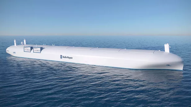
1. Autonomous ships

Image: Rolls-Royce
        
You’ve heard of driverless cars – soon there may be skipperless ships.
Ocean shipping is a $380 billion dollar industry.
Like traffic on land, ocean traffic is a major source of pollution, can introduce invasive species, and even causes ocean road-kills.
For example, over 200 whales were struck by ships in the past decade.
Companies like Rolls Royce envision autonomous shipping as a way to make the future of the industry more efficient, clean and cost-effective.
Skipperless cargo ships can increase efficiency and reduce emissions by eliminating the need for accommodation for crew, but will require integration of existing sensor technology with improved decision-making algorithms.

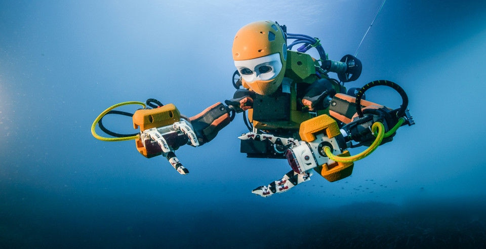
2. SCUBA droids

Image: Osada/Seguin/DRASSM
        
SCUBA divers working at extreme depths often have less than 15 minutes to complete complicated tasks, and they submit their bodies to 10 times normal pressure.
To overcome these challenges, a Stanford robotics team designed Ocean One: a humanoid underwater robot dexterous enough to handle archaeological artifacts that employs force sensors to replicate a sense of touch for its pilot.
Highly skilled humanoid robots may soon replace human divers in carrying out deep or dangerous ocean research and engineering tasks.

3. Underwater augmented reality glasses

Image: US Navy Photo by Richard Manley
        
Augmented and virtual reality technologies are becoming mainstream and are poised for enormous growth.
The marine sector is no exception.
US navy engineers have designed augmented vision displays for their divers – a kind of waterproof, supercharged version of Google Glass.
This new tech allows commercial divers and search and rescue teams to complete complex tasks with visibility near zero, and integrates data feeds from sonar sensors and intel from surface support teams.

4. Blue revolution

Image: InnovaSea
        
The year 2014 was the first in which the world ate more fish from farms than the wild.
Explosive growth in underwater farming has been facilitated by the development of new aquaculture tech.
Submerged “aquapod” cages, for example, have been deployed in Hawaii, Mexico, and Panama.
Innovations like this have moved aquaculture further offshore, which helps mitigate problems of pollution and disease that can plague coastal fish farms.

5. Undersea cloud computing

Image: Microsoft
        
Over 95% of internet traffic is transmitted via undersea cables.
Soon, data may not only be sent, but also stored underwater.
High energy costs of data centres (up to 3% of global energy use) have driven their relocation to places like Iceland, where cold climates increase cooling efficiency.
Meanwhile, about 40% of people on the planet live in coastal cities.
To simultaneously cope with high real estate costs in these oceanfront growth centres, reduce latency, and overcome the typically high expense of cooling data centres, Microsoft successfully tested a prototype underwater data centre off the coast of California last year.
Next-generation underwater cloud pods may be hybridized with their own ocean energy-generating power plants.

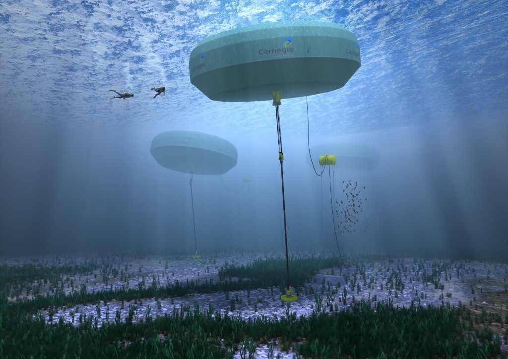
6. New waves of ocean energy

Image: Carnegie Wave Energy
        
The ocean is an enormous storehouse of energy.
Wave energy alone is estimated to have the technical potential of 11,400 terawatt-hours/year (with sustainable output equivalent to over 400 small nuclear power plants).
Technological innovation is opening up new possibilities for plugging into the power of waves and tides.
A commercial project in Australia, for example, produces both electricity and zero-emission desalinated water.
The next hurdles are scaling up and making ocean energy harvest cost-efficient.

7. Ocean thermal energy

Image: KRISO (Korea Research Institute of Ships & Ocean engineering)
        
Ocean thermal energy conversion technology, which exploits the temperature difference between shallow tropical waters and the deep sea to generate electricity, was successfully implemented in Hawaii last year at its largest scale yet.
Lockheed Martin is now designing a plant with 100 times greater capacity.
Drawing cold water in large volumes up from depths of over 1 kilometre requires large flexible pipelines made with new composite materials and manufacturing techniques.

8. Deep sea mining

Image: Nautilus Minerals
        
Portions of the seafloor are rich in rare and precious metals like gold, platinum and cobalt.
These marine mineral resources have, up until now, lain mostly out of reach.
New 300 tonne waterproof mining machines were recently developed that can now travel to some of the deepest parts of the sea to mine these metals.
Over a million square kilometres of ocean have been gazetted as mining claims in the Pacific, Atlantic, and Indian oceans, and an ocean gold rush may open up as early as 2018.
Mining the seafloor without destroying the fragile ecosystems and ancient species often co-located with these deep sea mineral resources remains an unsolved challenge.

9. Ocean big data

Image: Windward
        
Most large oceangoing ships are required to carry safety sensors that transmit their location through open channels to satellites and other ships.
Several emerging firms have developed sophisticated algorithms to process this mass influx of ocean big data into usable patterns that detect illegal fishing, promote maritime security, and help build intelligent zoning plans that better balance the needs of fishermen, marine transport and ocean conservation.
In addition, new streams of imagery from nanosatellite constellations can be analysed to monitor habitat changes in near-real time.

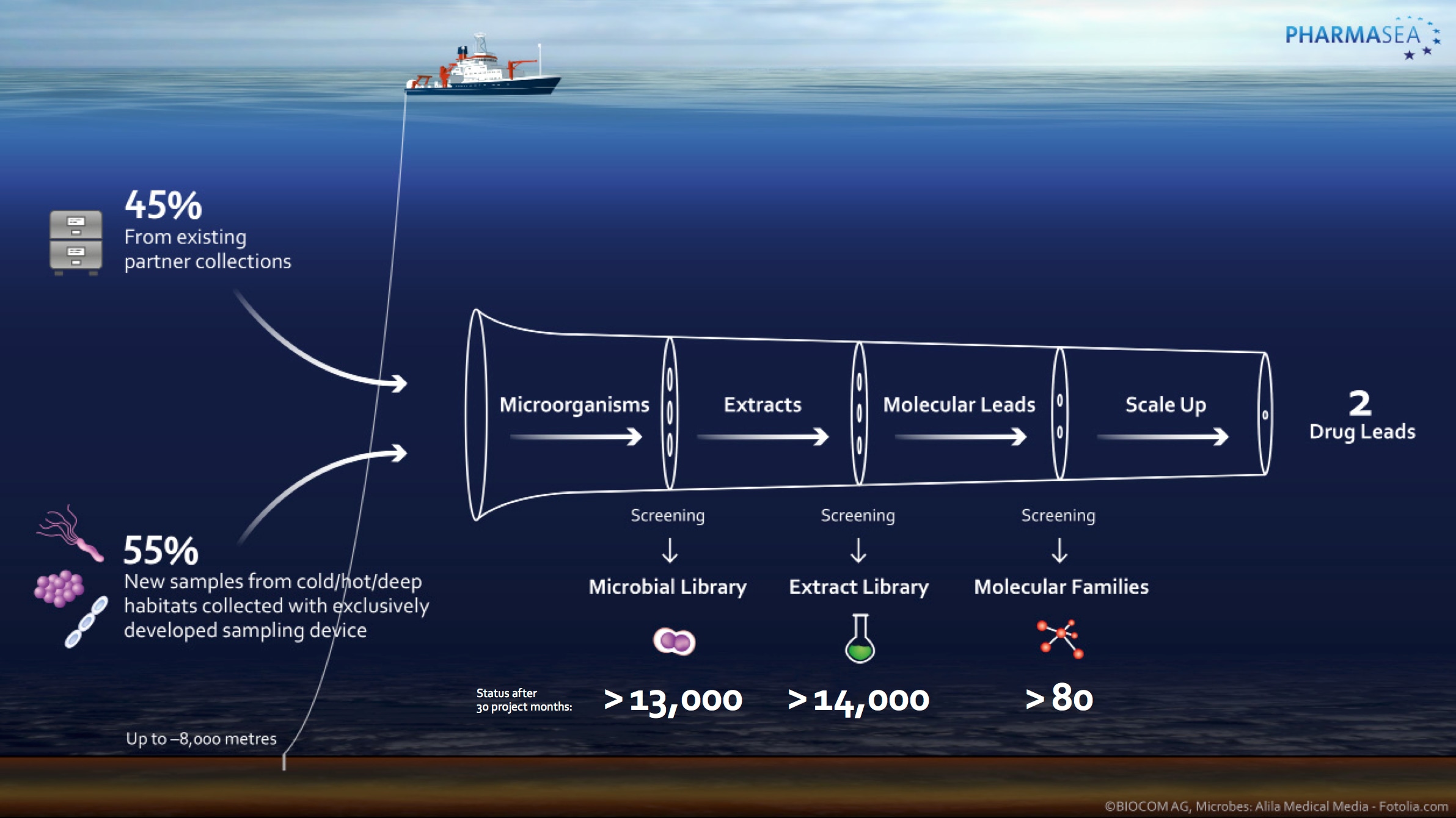
10. Medicines from the seas

Image: PharmaSea
        
The oceans hold vast promise for novel life-saving medications such as cancer treatments and antibiotics.
The search for marine-derived pharmaceuticals is increasing in momentum.
The European Union, for example, funded a consortium called PharmaSea to collect and screen biological samples using deep sea sampling equipment, genome scanning, chemical informatics and data-mining.

11. Coastal sensors

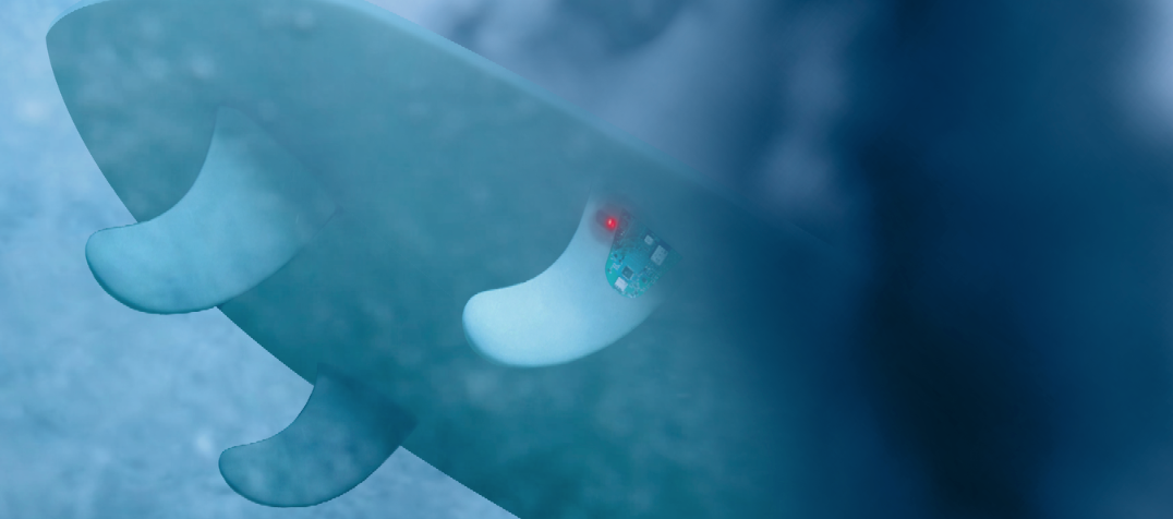
Image: Smartfin
        
The proliferation of low-cost, connected sensors is allowing us to monitor coastlines in ways never possible before.
This matters in an ocean that is rapidly warming and becoming more acidic as a result of climate change.
Surfboard-embedded sensors could crowd-source data on temperature, salinity and pH similar to the way traffic data is being sourced from drivers’ smartphones.
To protect the safety of beachgoers, sonar imaging sensors are being developed in Australia to detect sharks close to shore and push out real-time alerts to mobile devices.

12. Biomimetic robots

Image: Boston Engineering
        
The field of ocean robotics has begun borrowing blue prints from the world’s best engineering firm: Mother Nature.
Robo-tuna cruise the ocean on surveillance missions; sea snake-inspired marine robots inspect pipes on offshore oil rigs; 1,400 pound robotic crabs collect new data on the seafloor; and robo-jellyfish are under development to carry out environmental monitoring.
That ocean species are models for ocean problem-solving is no surprise given that these animals are the result of millions of years of trial and error.

Outlook

Our fate is inextricably linked to the fate of the oceans.
Technological innovation on land has helped us immeasurably to clean up polluting industries, promote sustainable economic growth, and intelligently watch over changes in terrestrial ecosystems.
We now need ocean tech to do the same under the sea.
As the marine industrial revolution advances, we will need to lean heavily on innovation, ingenuity and disruptive tech to successfully take more from the ocean while simultaneously damaging them less.

Links :

Thursday, September 29, 2016

Geographer: China’s claim to South China Sea not rooted in History

A map of China’s shifting definition of the so-called Nine-Dash Line.
US State Dept. Image

From USNI News by John Grady

A British geographer and journalist described China’s claims to large swaths of seas and land formations off its coast are based on 20th-century events — from the Boxer Rebellion to the defeat of Japan in World War II — and not deeply rooted in its history.

This assertion brought several heated questions from the audience.

Bill Hayton, an associate fellow at London’s Chatham House and the author of South China Sea, The Struggle for Power in Asia, named one of The Economist’s Books of the Year in 2014 and a journalist with the BBC said in response to a question that Beijing’s claims are valid “because [these territories] are ours” historically, said “a hundred years ago you [Chinese citizens] wouldn’t feel” the same way.
For much of China’s past, most of the South China Sea was viewed as “a place where pirates roam.”
His previous book Vietnam: Rising Dragon describes the diplomatic, social, political, and economic issues facing modern Vietnam. Hayton has presented widely on the South China Sea and other Southeast Asian issues in Indonesia, Malaysia, the Philippines, Singapore, the United Kingdom, and the United States.

Speaking Thursday at the Center for Strategic and International Studies, a Washington, D.C. think tank, he added, now, “every Chinese child is taught James Shoal is the southernmost part of Chinese territory.” The shoal is under water and claimed by China, Taiwan and Malaysia.
It is more than 1,000 miles from the Chinese mainland and 50 miles from the Malaysia coast.

The CSIS Asia Maritime Transparency Initiative and the Southeast Asia Program are pleased to invite you to a discussion with Bill Hayton, associate fellow at Chatham House.
Hayton will argue that the current tensions in the South China Sea can be traced back to the muddled origins of China’s claims in the early twentieth century.
He will show evidence that China’s claim to islands in the South China Sea emerged in 1909 and was further developed after 1933.
He will explain how Chinese academics and officials came to draw the “U-shaped line” by copying Western maps—and in the process incorporated mistakes and misunderstandings with consequences that still trouble the region decades later.

In answering a question about whether the media are increasing tensions over the disputes in the East and South China Seas, Hayton said, “The story has shifted” from one of China’s claims in the early 20th century in disputes with Japan and France over pieces of territory to one of who has the most influence in the region — Beijing or Washington.

He said the international arbitration panel’s recent ruling against China in a dispute with the Philippines over its so-called “9-Dash Line” territorial claims fell within the rules laid out in the United Nations Convention on the Law of the Sea that the Spratlys were not islands.
“There are no records of settled families” by the Chinese on them. The treaty calls for “human habitation, so they [aren’t] islands in that sense.”

Hayton added that Beijing was an early and strong supporter of the treaty “to stop countries from” making territorial claims like the ones it made in the case over the Scarborough Shoal brought by Philippine case.


1947 Nanhai Zhudao (cropped)

The first time the “9-Dash Line” appears in an official document is 1946″ and includes the Spratlys in a 1947 map, he said.
The timing was part of an agreement among the Allies that “all the territory stolen from China [by Japan] will be returned.”
The question was, “Where do China’s borders lay?”

Although China did not do much surveying work in the South China Sea and its fishermen did not continually inhabit the reefs and shoals, Beijing began producing in the early decades of the 20th century “maps of national humiliation.”
They indicated certain land features also claimed by Japan, Korea, Malaysia and the Philippines were under its control.
The “line,” which has shifted several times, was to make the territory appear to be contiguous.

China propaganda video

Hayton said what moved Chinese imperial officials in the early 20th century to make these first claims was to “show it is standing up to foreigners.”
The imperial government was trying to regain control of its own affairs and territory, usually close to the mainland, and solidify support with its people.

Later Chinese Republic officials continued these moves by “sticking in flags” on the Paracel Islands and sticking “one in the eye for the Japanese or anyone else,” who didn’t respect its sovereignty and claims.

At the beginning of his presentation, Hayton said China’s claims in the disputed waters “are just as incoherent as others” to these islands, reefs, barriers and shoals.
He said Beijing is making these claims out of a “sense of entitlement,” which shows no signs of going away.

Links :

Wednesday, September 28, 2016

Scientists to survey uncharted seafloor area


Scientists to survey uncharted seafloor area

From GNS Science

Scientists set off today on a 21-day voyage to map a previously uncharted section of the Colville Ridge, a large and mountainous seafloor structure about 500km northeast of Auckland.


More than half of the Colville Ridge, which covers an estimated 100,000km2, sits within New Zealand’s Exclusive Economic Zone yet until the last few years very little was known about it.

Being undertaken by GNS Science, the voyage will take place on NIWA’s deepwater research ship Tangaroa as part of a long-term programme to survey regions within New Zealand’s offshore territory.

Scientists will use the ‘holy trinity’ of seafloor mapping techniques – sonar mapping, as well as measurements of gravity and magnetism, supplemented by seafloor rock sampling.
These techniques complement each other and are considered essential to obtaining meaningful information about the seafloor and its underlying geological structures.

 Colville Ridge with the GeoGarage platform (NZ Linz nautical chart)

The mission builds on two earlier voyages, in 2013 and 2015, that mapped southern parts of the Colville Ridge totalling 40,000km2.
The maps produced during these voyages show a vast mountainous ridge dotted with extinct volcanic cones and peaks rising 1.5km above the surrounding seafloor.
Co-chief scientist on the voyage, Fabio Caratori Tontini, said the crew was looking forward to discovering the submarine landscape of the northern part of the ridge.

The voyage will produce the first comprehensive, high-definition seafloor map, geophysical data sets and rock samples along the northern section.
The information will provide new knowledge and understanding about the region’s ancient volcanism.

 A large area of seafloor east of Auckland has thrown up a few surprises for scientists.
Little was known about the submerged Colville Ridge until two weeks ago when 17,500 square kilometres of it was mapped in detail for the first time by a research ship.
That is an area equivalent in size to Auckland and Northland combined, or just over half the size of Belgium, or about the same size as Kuwait or Swaziland.
It is cut by large faults and has volcanic cones sitting atop of the ridge.
From the bottom of its valleys to the top of its peaks measures about 2km...
source : (GNS Science, 2013)

The Colville Ridge is millions of years old and represents a key piece to better understand the geological puzzle of the region, which includes determining the role of plate tectonics in shaping the ocean floor in the northern part of our EEZ.

Christian Timm, the other co-chief scientist on the expedition, said that understanding the formation of the Colville Ridge would give scientists valuable information to improve the understanding of the tectonic evolution of New Zealand’s vast underwater estate.
“Together with the data from the two previous expeditions, we will have acquired new maps covering about 60,000km2 of ocean floor, which is equivalent to the size of Ireland or half of New Zealand’s North Island,” Dr Timm said.
“These surveys will allow us to strip away the seawater and view New Zealand’s stunning underwater landscape in 3D. The new data will provide a framework for future studies that will include the deployment of underwater craft such as autonomous underwater vehicles (AUVs) and remotely operated vehicles (ROVs) to explore the seafloor in more detail,” he said.

The older Colville Ridge and neighbouring Kermadec Ridge have formed as a result of subduction of the Pacific tectonic plate underneath the Australian plate.
Both ridges stretch northeast from New Zealand towards Fiji and Tonga respectively.

There are four or five major ridge features in New Zealand’s offshore territory and the Colville Ridge is arguably the least known of them.

The voyage draws on Ministry of Business Innovation and Employment funding for the Tangaroa, while funding from GNS Science covers equipment and scientific staff on the vessel.

Links :

Tuesday, September 27, 2016

Canada CHS update in the GeoGarage platform

1 nautical raster chart added + 67 updated

Satellite industry is all at sea

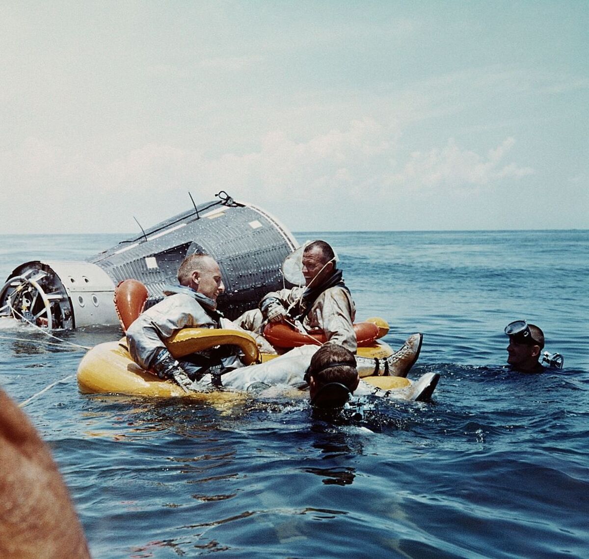
Photo : the heroic story of the Mercury Seven, the pioneer astronauts who risked their lives for America’s first manned space voyages.
(Project Mercury ran from 1959 through 1963, put the first American in space, and defined NASA’s manned space flights to come, from Gemini through Apollo.)

From Bloomberg by Leila Abboud

Satellite operator Inmarsat was founded 40 years ago to let ships communicate with land so rescuers could aid sailors.
The maritime business, which still provides half of sales and operating profit, set it apart from rivals who were focused on broadcasting and broadband.
As a result, the British company had lower margins than peers but was insulated from the competition and macro-economic storms that buffeted others.
Now, amid the tumult of a capacity glut in the sector, even Inmarsat is getting dragged under water.
Advances in high-throughput satellites are bringing more bandwidth online than ever.
This oversupply, which might triple capacity by 2020, will pressurize sales and margins for all the big satellite players.
Since Eutelsat issued a profit warning in May, investors have punished the sector.

 25th anniversary of our flagship maritime safety service, Inmarsat C – the only GMDSS-approved satellite system which, in 2015 alone, broadcast more than 600 distress alerts from vessels in urgent need.

That even Inmarsat, with its one-time maritime fortress, is getting hit shows how far the contagion has spread.
It also highlights a less understood change in the satellite business: how the capacity boom obliterates the once clear distinctions between the different satellite companies and the markets in which they operate.
Before, there was clear separation between fixed satellite service providers and mobile.
Inmarsat dominated the latter while SES, Eutelsat and Intelsat ruled in fixed.
Now, in the scramble to sell new capacity, the different players all encroach on each other's turf.
Plus the traditional satellite broadcasting business is under pressure from fiber and cable networks that carry TV signals quite well.

Blurred Lines

With its maritime focus, Inmarsat differs from other satellite companies, but differences between them are blurring

Avanti figures reflect FYE 2015 recurring revenue, excluding the sale of spectrum.

Put it together, and you've got unprecedented change in a once dull sector.
Barclays' analysts predict a 2-3 percent drag on industry revenues for the next five years
Inmarsat's experience is instructive.
In addition to maritime, it serves governments and the military and supplies emergency cockpit communications.
But it faces competition in those areas from mobile upstarts such as Iridium as well as fixed satellite rivals Viasat and Intelsat.
The squeeze is on from both sides.
Inmarsat needs to offer faster broadband speeds to ships and planes, not the dial-up slow stuff it used to do.
That's why it committed to a series of new satellites called Global Express, which are entering service this year.
Inmarsat wants to use them to expand into new markets such as passenger jet Wi-Fi.
But it means higher capex, while revenues are less certain.
Of course, Inmarsat's competitors are suffering too.
Its growth outlook to 2018 is ahead of the pack.
The top five operators -- who control about 60 percent of sector revenue -- are all revisiting their business models. 

Choppy Waters

Inmarsat's traditional leadership in linking ships with satellite communications no longer insulates it from competition as much as it once did
And there may be a positive side to all this new capacity if the traditional suppliers have the imagination to use it to break into new markets, such as aircraft Wi-Fi, or use cheaper prices to expand in consumer broadband.
Yet it's all pretty murky predicting how this will shake out for a sector that's been used to relative stability, generous dividends and monster profit margins.
Inmarsat will have to get used to much choppier waters.

Links :

Monday, September 26, 2016

High-seas piracy hits a two-decade low


From The Economist by the Data team

PIRATES, the scourge of the high seas, were mostly kept at bay during the first half of 2016. According to the International Maritime Bureau’s Piracy Reporting Centre, there were 98 attacks worldwide in the six months to July, the lowest figure in 21 years.
Indonesia’s waters remained the most pirate-infested in the world.
The sprawling archipelago of 17,000 islands suffered 21 attacks and three attempted attacks.
The waters along the coast of Somalia, once a piracy hotspot, have seen a dramatic decline in attacks since 2011. Piracy off Nigeria’s coast, meanwhile, has increased.

Suspected pirates wait for members of the counter-piracy operation to board their boat.
Photo: US Navy/Jason R Zalasky

The recent decline in global piracy can be attributed in part to better security on ships.
For years, the UN’s International Maritime Organisation discouraged boat owners from arming their crews.
Ships tried in vain to defend against heavily-armed pirates using little more than diligent watch-keeping and water cannons.
In the mid-2000s, facing rising insurance and ransom costs, shipping companies began employing private security contractors.
These firms are increasingly supplied by “floating armouries” to help evade laws that bar crews from bringing weapons into territorial waters.


Better policing of the high seas has also played a part. In 2008, following a spate of pirate attacks in the Gulf of Aden, America, the European Union and NATO sent a flotilla of warships to patrol the coast of Somalia.
The large naval presence today deters all but the most ruthless buccaneers.
But “Operation Ocean Shield”, NATO’s counter piracy mission, is scheduled to end in December.
Perhaps it is time to batten down the hatches once again.

Links :

Sunday, September 25, 2016

This mind-blowing infographic shows the incredible depth of the earth's oceans

People sometimes forget that oceans contain a lot more than the water you see just beneath the surface.
The depths below the ocean’s surface comprise a staggering 95% of the earth’s living space, and much of it is unexplored by humans.
To put into perspective just how deep the oceans go, Xkcd.com created this illustration (click the image for a larger version):

From BusinessInsider by Pamela Engel

As you can see, most of the ocean doesn’t even see sunlight.
Even scientists aren’t familiar with everything that’s down there.
In fact, getting to the deepest reaches of the ocean is so expensive that some people — like Oscar-winning director James Cameron — take it upon themselves to explore underwater spaces rarely visited by humans.
Cameron visited the Mariana Trench, the deepest place on earth at seven miles below the surface of the Pacific Ocean, in a minisubmarine in 2012.
He was only the second person to visit that area of the ocean.
He didn’t see any sea monsters, but he described the experience as out of this world.