
From GNS Science
New Zealand and American scientists will use one of the world’s most sophisticated unmanned submarine vehicles during the next three weeks to investigate two seafloor volcanoes in the Kermadec Arc, northeast of Bay of Plenty.

Kermadec Ridge with the Marine GeoGarage
The project is a collaboration involving GNS Science, the Royal New Zealand Navy, and US-based Woods Hole Oceanographic Institution, which owns and operates the autonomous underwater vehicle Sentry.
The multi-purpose 18-day voyage, scheduled to leave Auckland on March 3, is built around a regular Navy supply trip to Raoul Island on HMNZS Wellington.
This particular voyage will support GNS Science, the Department of Conservation, and the Meteorological Service.
Sentry - the autonomous underwater vehicle - will be deployed from the Royal New Zealand Navy patrol vessel for its day-long missions to skim over the seafloor and gather data.
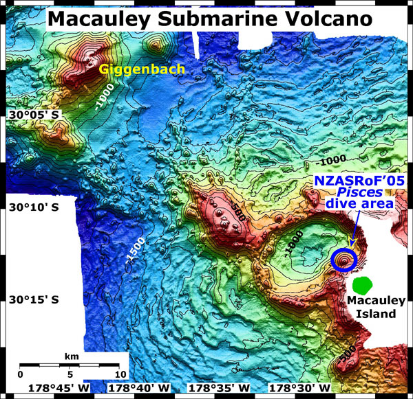
The target seafloor volcanoes – Macauley Caldera and Giggenbach - are actively venting hot water and gases on the seafloor and are within 100km of Raoul Island.
Both volcanoes have been investigated by surface ships on previous voyages, but this will be the first time they have been explored extensively at close range.
Sentry will travel over the volcanic structures at walking speed and at a pre-determined height above the seafloor.
It will build detailed three-dimensional maps and measure up to 12 different chemical and physical parameters of the ocean and seabed.
It will return to the ship after each mission to download terabytes of data, have its batteries recharged, and to be programmed for its next deployment.
It is scheduled to make eight dives during the voyage, covering about 10 square kilometres of seafloor per dive.

Macauley
Caldera and Giggenbach with the Marine GeoGarage
Project leader Cornel de Ronde said the voyage was part of a long-term GNS Science programme to build detailed maps and collect geological data, including hydrothermal venting, at about 30 major submarine volcanoes in the Kermadec Arc, which runs between Bay of Plenty and Tonga.
This will be Sentry’s second visit to New Zealand.
During a GNS Science-led voyage in 2011, it gathered detailed information on four submarine volcanoes northeast of White Island.
“Sentry is the ideal vehicle for obtaining comprehensive information and understanding on the seafloor and the environment around these submarine volcanoes,” said Dr de Ronde, a marine geologist at GNS Science.
“It provides the appropriate level of detail on the geology of the seafloor, the hydrothermal systems, deep-sea habitats, and the occurrence of mineral deposits.”
The project is part of a multi-year research programme by GNS Science to map and understand tracts of seafloor in New Zealand’s vast offshore territory.
New Zealand has sovereign rights over an area of seafloor totalling 5.7 million square kilometres.
This is equivalent to 14 times the size of California or 1 percent of the Earth’s surface.
This area is largely unmapped and unexplored.
The New Zealand landmass equates to just 4 percent of this submerged area – sometimes referred to as the continent of Zealandia.
GNS Science, with support from its international colleagues, has been systematically investigating the volcanic features of the Kermadec Arc since the late 1990s.

Macauley caldera and sand waves, image created by Susan Merle of NOAA
Background: The free-swimming Sentry is arguably the world’s most sophisticated autonomous underwater vehicle for marine geology applications. Battery-powered and weighing 1.25 tonnes, it is capable of diving to 6000m and spending up to 45 hours under water per mission.
It has four pivoting wings with a propeller on each wing.
It can skim over seafloor terrain at any height and is equipped with about a dozen science and engineering sensors to measure physical and chemical parameters of the ocean and seafloor.
All sensor data is stored on the vehicle and retrieved on recovery.
Woods Hole Oceanographic Institution in the United States owns and operates Sentry.

The free-swimming Sentry autonomous underwater vehicle will spend the
next two weeks exploring submarine volcanoes near Raoul Island in the
Kermadec Arc.
Sentry is a part of the National Deep Submergence Facility (NDSF) which is a joint venture involving the US National Science Foundation, the National Oceanic and Atmospheric Administration, and the Office of Naval Research. NDSF, which comprises manned, remote, and autonomous vehicles, is operated by Woods Hole Oceanographic Institution on behalf of the international scientific community.
There are dozens of submarine volcanoes between White Island and Tonga, and many have active hydrothermal vent systems which give rise to extensive seafloor mineral deposits.
The mission with Sentry will help to improve the understanding of the relationships between the hydrothermal venting, the mineral deposits, and the specially adapted marine life that thrives in the hot and chemically-rich environments around the volcanoes.

Macauley Caldera
Macauley Caldera is an oval-shaped submarine crater about 10km by 5km, or about the size of Wellington Harbour. It produced a major eruption about 2000 years ago.
The crater has steep walls and numerous sites are venting hydrothermal fluids.
Venting at one site in particular, a young cone that has grown up inside the crater, is extremely vigorous.
An unusual feature of Macauley are giant sand waves or seafloor undulations that extend outwards for many kilometres on the flanks of the caldera.
These features have been observed at only a handful of submarine volcanoes worldwide.
Sentry will dive inside the caldera to map it in detail and analyse the hydrothermal vents.
It will also study the giant sand wave formations with sonar to see if they are related to the eruption of 2000 years ago.
This will reveal their thickness and whether their structure is chaotic or layered.
A chaotic structure would suggest they were formed by a single large eruption and a layered structure would point to a much less violent formation process.

Giggenbach volcano
Giggenbach is a simple cone volcano similar in size and style to Mount Ngauruhoe.
It is located 800km northeast of the North Island and about 30km from Macauley Caldera.
It is shallower than most submarine volcanoes with its summit about 120m below the sea surface. During a 2005 expedition, scientists found diffuse hydrothermal venting around its summit.
However, the feature that sets Giggenbach apart is the huge volume of carbon dioxide discharging into the sea from one particular vent area.
Scientists know of only one other submarine volcano in the world – NW Eifuku volcano in the Mariana Arc – that is venting more carbon dioxide than Giggenbach.
On this voyage, scientists plan to further investigate the nature of its venting.
Links :
No comments:
Post a Comment