
China 9 dash line
From Rappler by Ayee Macaraig
The US State Department said China failed to clarify its controversial 9-dash line claim over the South China Sea in a way consistent with international law.
The Department’s Bureau of Oceans and International Environmental and Scientific Affairs published a study on Friday, December 5, assessing the consistency of China’s maritime claims with international law.
The study was released ahead of a December 15 deadline for China to respond to the Philippines’ historic arbitration case on the disputed sea before an international tribunal.
The US study also came just two days before China released its own position paper detailing its objection to the case.
In the 26-page paper, the US said that China’s position on its maritime claims is unclear.
It analyzed 3 possible interpretations of the 9-dash line, two of which “do not have a proper legal basis under the law of the sea.”
“Unless China clarifies that the dashed-line claim reflects only a claim to islands within that line and any maritime zones that are generated from those land features in accordance with the international law of the sea, as reflected in the LOS Convention, its dashed-line claim does not accord with the international law of the sea,” the paper concluded.
The US was referring to the 1982 United Nations Convention on the Law of the Sea (UNCLOS), which the Philippines cited in its arbitration case to invalidate the 9-dash line.
Manila is a key treaty ally of Washington.
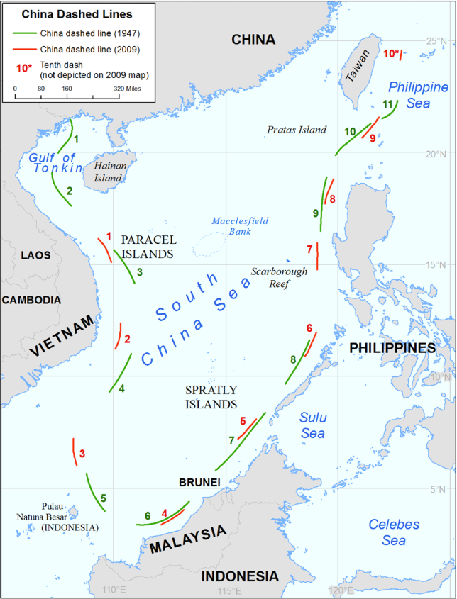
Comparaison of dashed line in 2009 and 1947 maps

Distances between dashes and land features :
As shown on Map 4 to this study, the dashes are generally closer to the surrounding coasts of
neighboring States than they are to the closest islands within the South China Sea.
In other
words, the distances between the dashes and the islands are generally farther than the
aforementioned distances to the surrounding coasts.
At their closest points, the dashes are 84 nm
from the nearest island within the Paracel Islands (dash 1 to Triton Island), more than 46 nm
from the nearest island within the Spratly Islands (dash 5 to Half Moon Shoal), and nearly 75 nm
from Scarborough Reef (dash 7).
Some of the dashes are far from the nearest islands within the
South China Sea.
For instance, dash 3 is 235 nm from the nearest such island, which is Spratly
Island.
Dash 4 is 133 nm from Louisa Reef.
Dash 8 is 179 nm from the closest island on
Scarborough Reef.
The US State Department said that the study was part of a series to “examine a coastal state’s maritime claims and/or boundaries and assess their consistency with international law.”
Yet the timing of the publication was close to the deadline for China’s counter-pleading.
The paper reiterated earlier statements of State Department officials asking China to clarify the 9-dash line.
“Although the US Government is active in protesting historic claims around the world that it deems excessive, the United States has not protested the dashed line on these grounds because it does not believe that such a claim has been made by China. Rather, the United States has requested that the Government of China clarify its claims.”
Chinese Foreign Ministry Spokesman Hong Lei criticized the US study on Tuesday, December 9.
"The US report ignores the basic facts and international legal principles and is contrary to its promises not to take a position or sides. It is not helpful to the resolution of the South China Sea issue and the peace and stability of the South China Sea. We urge the US side to abide by its promises, act and speak cautiously and objectively and fairly view and deal with the relevant issue," Reuters quoted him as saying.
China criticizes what it views as US meddling in its disputes with its neighbors.
Vietnam, Malaysia, Brunei and Taiwan also claim parts of the South China Sea, believed to hold vast deposits of oil and gas, and a major shipping route.
Beijing claims almost the entire South China Sea, citing the contentious line to assert “indisputable sovereignty.”
Declaring the line inconsistent with UNCLOS is the main claim of the Philippines in its arbitration case.


In this June 27, 2014 photo, a printing worker holds a new officially approved map of China that includes the islands and maritime area that Beijing claims in the South China Sea, at a factory in Changsha in south China’s Hunan province.
‘Failing legal test’
The US study analyzed the 9-dash line using 3 interpretations: as a claim to islands, as a national boundary, and as a historic claim.
It is only the first interpretation where the US said the line could be consistent with UNCLOS.
As to the third interpretation, the paper said the line failed each element of a legal test:
- No open, notorious, and effective exercise of authority over the South China Sea
- No continuous exercise of authority in the South China Sea
- No acquiescence by foreign states in China’s exercise of authority in the South China Sea.
“The law of the sea does not permit [maritime] entitlements to be overridden by another state’s maritime claims that are based on ‘history,’ To the contrary, a major purpose and accomplishment of the Convention is to bring clarity and uniformity to the maritime zones to which coastal States are entitled,” the paper stated.
On the second interpretation of the line as a national boundary, the State Department said that this too is inconsistent with international law.
“Moreover, dashes 2, 3 and 8 that appear on China’s 2009 map are not only relatively close to the mainland shores of other states, but all or part of them are also beyond 200 nautical miles from any Chinese-claimed land feature,” it said.

While China released a position paper on the arbitration case, it was silent on the merits of the Philippines’ claim questioning the 9-dash line.
Instead, it chose to focus on jurisdiction or technical issues on the admissibility of the Philippines’ claims.
Battle of papers?
Although the US is not a party to the dispute and the arbitration case, scholars said its paper contributed to discussion on the issue.
“It is a must-read for anyone interested in maritime security, the law of the sea, or China’s foreign policy,” said The Intrepeter, a blog of the Australia-based think tank Lowy Institute for International Policy.
China’s position paper is also sparking debate. American international law professor Julian Ku urged the Philippines to respond by releasing its pleading or memorial.
“As a legal document, [China’s] position paper is very well done and is the best legal analysis of the jurisdictional issues in the Philippines arbitration I have seen coming out of China, and certainly from the Chinese government,” he said on the legal blog Opinio Juris.
“I’m sure the Philippines will be tempted to release at least the jurisdictional portion of their brief as well. I hope they do, since the public reaction to their legal arguments will be just as important as any ruling the tribunal makes,” Ku added.
Links :
- NYTimes : Territorial Disputes in the Waters Near China
- CNA : The South China Sea, assessing U.S. policy and options for the future
- GeoGarage blog : New map boosts China's maritime claims / China's line in the sea / Battle of the South China Sea charts / Ancient map irrefutable evidence that the Diaoyu Islands, the ancient belongs to China / Vietnam demands China removes illegal EEZ dotted line on online map
Lawfare : Transparency in Troubled Seas
ReplyDelete