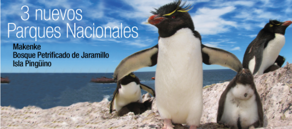
The new marine parks—Isla Pingüino Coastal Marine Park and Makenke Coastal Marine Park—were recently established by the National Congress in Argentina and will safeguard sea lions, penguins, dolphins, and other marine and coastal species.
"We commend the Government of Argentina for their conservation stewardship in creating this new network of marine protected areas," said Dr. Cristián Samper, President and CEO of the Wildlife Conservation Society.
"Isla Pingüino and Makenke Coastal Marine Parks now protect vital wildlife populations for posterity and create new opportunities for Argentina's ecotourism industry."
Stretching some 80 miles south of Puerto Deseado and extending 12 miles out to sea, Isla Pingüino covers nearly 1,800 square kilometers (720 square miles) of ocean and cliff-bordered coastline.
The new protected area contains large populations of South American sea lions, red-legged cormorants, and one of the largest colonies of imperial cormorants found anywhere (with more than 8,000 breeding pairs).
Isla Pingüino also boasts one of the only colonies of rockhopper penguins on the coast of Patagonia.
Farther south, the Makenke Coastal Marine Park begins at the entrance of the Ría San Julián, covering almost 600 square kilometers (230 square miles) of shore and ocean.
The park contains the largest colony of rare red-legged cormorants in the country.
It also protects breeding colonies of the dolphin gull, a rare scavenger, and pods of the small but spectacular black and white Commerson's dolphin
A distinct landscape : the stark and scenic coastline of Makenke Coastal Marine Park
Credit: G. Harris/Wildlife Conservation Society.
Both marine protected areas are steeped in history as well as natural wonders. Charles Darwin traveled to the region now contained in Isla Pingüino in 1833, describing the wildlife he observed there during his seminal voyage aboard the HMS Beagle.
Makenke Coastal Marine Park now borders the inlet of San Julian, where in 1520 Ferdinand Magellan executed and marooned a group of mutineers intent on aborting what would become the world's first circumnavigation of the globe.
"We commend the National Congress in Argentina for passing laws to create these new marine parks, which will protect the country's natural heritage given what will likely be an increase in development along the coast in years to come," said Dr. Julie Kunen, Director for WCS's Latin America and Caribbean Program.
Dr. Caleb McClennen, Director of WCS's Marine Program, said: "Isla Pingüino and Makenke Coastal Marine Parks continue a tradition of conservation teamwork, with organizations such as WCS providing support to the government in protecting both coastal breeding areas for mammals and birds and the marine habitats they rely upon."
Isla Pingüino and Makenke Coastal Marine Parks were made possible as a result of work conducted by Dr. Patricia Gandini, President of the National Parks Service, and Dr. Esteban Frere of the Universidad Nacional de la Patagonia Austral.
Both biologists began studying the wildlife of the coast of Santa Cruz with support of WCS in 1985.
Both areas were identified as priority conservation sites by the Patagonia Coastal Zone Management Plan project, carried out by both the Wildlife Conservation Society and the Fundación Patagonia Natural with support from the Global Environmental Facility and the UNDP (United Nations Development Program).
Support for the research was also provided by the Consejo Nacional de Investigaciones Científicas y Técnicas (Conicet).
A place to return : Makenke contains one of the largest breeding colonies of red-legged cormorants in Argentina.
Credit: G. Harris/Wildlife Conservation Society.
WCS has been involved in the conservation of coastal Patagonia since the 1970s, beginning with Dr. Roger Payne's behavioral work on southern right whales, and continues to this day with research by WCS's Global Health Program on new threats to their survival.
WCS began a long-running study on Magellanic penguins in the 1980s.
That work led to conservation efforts that helped reduce the number of penguin deaths due to oil spills at sea from more than 40,000 a year to fewer than 1,000 annually, and helped move shipping lanes 30 miles offshore to avoid spills affecting seabird colonies.
WCS has also been conducting research on southern elephant seals, South American sea lions, rockhopper penguins, cormorants, gulls, terns, and other species that breed along the shores of Patagonia.
These studies informed the region's first atlas of breeding seabirds, a work designed to guide management decisions on fisheries and other natural resource usage.
Over the past 40 years WCS has helped Argentina transition from harvesting of coastal wildlife to a burgeoning tourism industry based on its spectacular coastal species.
These two new parks are the latest addition to the country's extraordinary marine conservation effort.
WCS's efforts to help protect wildlife on the Argentine coast and sea are generously supported by the Liz Claiborne and Art Ortenberg Foundation, the Mitsubishi Corporation Foundation for the Americas, the Waitt Foundation, and others.
Measurements of individual Galileo horizontal position fixes performed for the first time using the four Galileo satellites in orbit plus the worldwide ground system between 1000 and 11:00 CET on Tuesday 12 March 2013, showing an overall horizontal accuracy over ESTEC in Noordwijk, the Netherlands, of 6.3 m. The obtained accuracy in the 10 meters range fulfills expectations.
Europe’s new age of satellite navigation has passed a historic milestone – the very first determination of a ground location using the four Galileo satellites currently in orbit together with their ground facilities.
This fundamental step confirms the Galileo system works as planned.
A minimum of four satellites is required to make a position fix in three dimensions.
The first two were launched in October 2011, with two more following a year on.
“Once testing of the latest two satellites was complete, in recent weeks our effort focused on the generation of navigation messages and their dissemination to receivers on the ground,” explained Marco Falcone, ESA’s Galileo System Manager.
This first position fix of longitude, latitude and altitude took place at the Navigation Laboratory at ESA’s technical heart ESTEC, in Noordwijk, the Netherlands on the morning of 12 March, with an accuracy between 10 and 15 metres – which is expected taking into account the limited infrastructure deployed so far.
A 3D presentation of the Galileo satellite navigation system, a joint development by the European Union and European Space Agency.
This constellation of satellites will allow users to pinpoint their
location anywhere on Earth -- launched on 20 October
2011.
This fix relies on an entirely new European infrastructure, from the satellites in space to the two control centres in Italy and Germany linked to a global network of ground stations on European territory.
“The test of today has a dual significance: historical and technical,” notes Javier Benedicto, ESA’s Galileo Project Manager.
“From the historical perspective, this is the first time ever that Europe has been able to determine a position on the ground using only its own independent navigation system, Galileo.
“From the technical perspective, generation of the Galileo navigation messages is an essential step for beginning the full validation activities, before starting the full deployment of the system by the end of this year.”
With only four satellites for the time being, the present Galileo constellation is visible at the same time for a maximum two to three hours daily.
This frequency will increase as more satellites join them, along with extra ground stations coming online, for Galileo’s early services to start at the end of 2014.
With the validation testing activities under way, users might experience breaks in the content of the navigation messages being broadcast. In the coming months the messages will be further elaborated to define the ‘offset’ between Galileo System Time and Coordinated Universal Time (UTC), enabling Galileo to be relied on for precision timing applications, as well as the Galileo to GPS Time Offset, ensuring interoperability with GPS. In addition, the ionospheric parameters for single frequency users will be broadcast at a later stage.
A European partnership
The definition phase and the development and in-orbit validation phase of the Galileo programme were carried out by ESA and co-funded by ESA and the European Community.
The Full Operational Capability phase is managed and fully funded by the European Commission.
The Commission and ESA have signed a delegation agreement by which ESA acts as design and procurement agent on behalf of the Commission.
4850 CAPE ST FRANCIS TO BACCALIEU ISLAND AND HEART'S CONTENT
So 688charts (1658 including sub-charts) are available in the Canada CHS layer. (see coverage)
Note : don't forget to visit 'Notices to Mariners' published monthly and available from the Canadian Coast Guard both online or through a free hardcopy subscription service. This essential publication provides the latest information on changes to the aids to navigation system, as well as updates from CHS regarding CHS charts and publications. See also written Notices to Shipping and Navarea warnings : NOTSHIP
National Geographic Explorer-in-Residence Enric Sala dives deep into the waters of one of the most pristine places on Earth — the Pitcairn Islands — only to discover its delicate ecosystem is not as unspoiled as it may seem.
Nadine Christian is considered the first novelist from her island home’s 223 years of civilized existence.“Remembering Love” by all accounts is a fine piece of work.
However, in fairness to Christian anything good that happens within her remote spec of volcanic rock called Pitcairn Island will always be prefaced by its notorious past.
Historians and lovers of true adventure on the high seas hear the words “Pitcairn Island” and instinctively think of Lt. William Bligh, Fletcher Christian and Mutiny on the Bounty in 1789.
From the mutiny, thoughts unconsciously turn to bleak isolation of the insurgents’ abysmal resting place — Pitcairn Island.
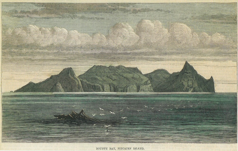
An early drawing of Pitcairn Island – from the collection of Maurice Allward.
Pitcairn is a small, but distinctive, island in the heart of the southern South Pacific.
It is more than 3,300 nautical miles from New Zealand and 1,400 nautical miles from Tahiti, and with a population of about 60, it represents one of the most remote and inaccessible jurisdictions on Earth. Still, its tropical beauty and haunting features and sad reminders of the past like “Christian’s Cave” continue to make for an appealing adventure.
You cannot fly into Pitcairn because its 2.5 square miles of land mass are mostly mountainous.
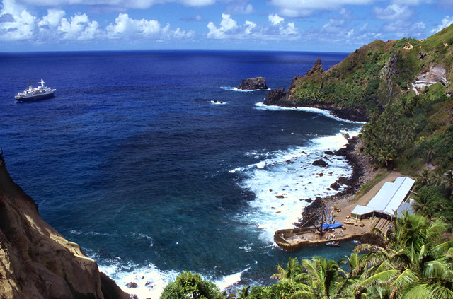
From neighboring New Zealand, it is 10 days by yacht.
Because of strong ocean currents and jagged volcanic minefields, a yacht or small ship cannot land there.
Islanders send long boats out to meet visitors and supply ships.
Bénard, Robert, b. 1734. “Carte et vues de l’Isle Pitcairn.” Copperplate map (and views), with added color, 10 × 25 cm. on sheet 25 × 30 cm. From John Hawkesworth’s Relation de voyages entrepris par ordre . . . et successivement exécutés par le commodore Byron, le capitaine Carteret, le capitaine Wallis et le capitaine Cook . . . (Paris, 1774). [Historic Maps Collection] We continued our course westward till the evening of Thursday the 2d of July [1767], when we discovered land to the northward of us. Upon approaching it the next day, it appeared like a great rock rising out of the sea: it was not more than five miles in circumference, and seemed to be uninhabited; it was, however, covered with trees, and we saw a small stream of fresh water running down one side of it. I would have landed upon it, but the surf, which at this season broke upon it with great violence, rendered it impossible. . . . [I]t having been discovered by a young gentleman, son to Major Pitcairn of the marines, who was unfortunately lost in the Aurora, we called it Pitcairn’s Island. [Hawkesworth, vol. 1, p. 561] The mutineers of the HMS Bounty would find this information about a remote, uninhabited (but inhabitable) island useful when they sought a place to hide from the British Admiralty in 1779.
However, in January 1790, no island could have been a more perfect haven than Pitcairn for the mutineers of the Bounty.
The island was misplaced on British charts, and it was here that Christian and eight other dissenters, plus 24 Tahitian men and women settled.
The ship was burned in what is known today as Bounty Bay and its remains are still visible.
After nearly two years of being isolated on the island, most of the mutineers, including Fletcher Christian were murdered.
Some accounts say Christian committed suicide, while others believe he somehow escaped Pitcairn and returned to England, hiding out for the remainder of his life. John Adams, the last survivor of the seized ship, insisted Christian was killed by the Tahitians.
The cave Christian lived in remains a focal point of the island.
It rises some 250 feet and provides a spectacular view of the vast blue Pacific.
It is not much more than a small indentation, but it is where Christian often sat, scanning the ocean hoping not to be discovered by a distant British ship.
All of the inhabitants of Pitcairn Island are descendants, or married to descendants, of the original mutineers including Nadine Christian.
She is the wife of a descendant of Fletcher Christian and the author of “Remembering Love,” an excellent first novel.
Two years ago I wrote about Caroline Alexander’s fine book, “The Bounty.”
Through the wonder of the Internet, the review was picked up by resident Sue O’Keefe who has since become an occasional pen pal, and through her, I met Nadine Christian.
The book has a strong focal point — a young girl returning to her Pitcairn Island home to rediscover her roots, linking pieces of her past together and, yes, finding love.
The story is woven with skillful dialogue, easy transition and credible island scenes that are the essence of Pitcairn’s beauty, mystery and magnetism.
Its pages, worth any book lover’s time, represent seeds of a promising dramatist.
Christian’s style has a way of carrying one off to the South Seas without exorbitant fare or throttling red tape.
Nadine went to Pitcairn from New Zealand in 2002.
She met and married into the Christian family, and as a result, explains, “I live with my husband, five children, four goats, two cats and 30 chickens.”
She is 40 and filled with energy to write novels, perhaps based loosely on Pitcairn’s past.
“I love it here,” Christian said.
“I enjoy the beauty, the stillness, the hard work and total unpredictability of each new day. It isn’t a 9-to-5 existence. It’s more like 24/7. It can be a bit claustrophobic at times, but the Internet and phone system opens you up to the world.
It’s like any small community. People niggle at times, but it’s never serious. I could have an argument with John Smith today, and tomorrow he may hear I’m out of milk and he’ll bring me a carton to tide me over. Yes, we do have our differences of opinion now and then, but in the end, we depend on helping each other.”
There was no happy ending for the majority of the 18 original mutineers.
Some were murdered. Some returned to England and hanged for their crime.
Some were pardoned, but forever lived in the shadows of a shameful past.
For Nadine Christian, however, happy and inspiring endings now and then can make for a fine calling card.
Three types of critically endangered but commercially valuable shark have been given added protection at the Cites (Convention on International Trade in Endangered Species) meeting in Bangkok.
Shark fins drying in the sun in Kaohsiung before processing. 30 percent of the world’s shark species are threatened or near threatened with extinction.
Photo Credit: Shawn Heinrichs for the Pew Environment Group
The body, which regulates trade in flora and fauna, voted by a two-thirds majority to upgrade the sharks' status.
Campaigners hailed the move as historic and said the vote represented a major breakthrough for marine conservation.
The decisions can still be overturned by a vote on the final day of this meeting later this week.
The oceanic whitetip, three varieties of hammerheads and the porbeagle are all said to be seriously threatened by overfishing.
Their numbers have declined dramatically in recent years, as the trade in shark fins for soup has grown.
Manta rays are killed for their gill plates which are used in Chinese medicine.
Shark supporters have been attempting to get Cites to protect these species since 1994.
But there has long been strong opposition to the move from China and Japan.
But a number of factors have changed the arithmetic.
Experts say the critical factor has been a shift in South American nations, who've come to understand that sharks are more valuable alive than dead.
"They've come to realise, particularly for those with hammerhead stocks, the tourist value of these species and the long term future that will be protected by a Cites listing," said Dr Colman O'Criodain from WWF International.
The oceanic whitetip was once a widespread large shark species, but its numbers show a drastic decline. It appears as bycatch in pelagic (open sea) fisheries, but its large fins are highly prized, used in shark's fin soup and in traditional medicine
Hammerhead sharks are known for their distinctive head shape which may have evolved in part to enhance vision. The great and scalloped varieties are endangered; the smooth hammerhead is considered vulnerable. All have been given added protection
Porbeagles are found in cold and temperate waters of the North Atlantic and Southern Hemisphere. Targeted commercial fishing and unintentional catches pose the biggest threat to this shark, which has a low reproductive rate
Thousands of sharks fins are laid out on roofs in Hong Kong for airing and sorting.
While the vote to upgrade these shark species to Appendix 2 does not ban the trade, it regulates it. Both exporting and importing countries must issue licences.
If a nation takes too many of these species, they can be hit with sanctions on the range of animal and plant products that are governed by Cites.
As the votes went on there were smatterings of applause in the hall and some high fives among campaigners.
"It is really significant for Cites to come of age like this," Dr Susan Lieberman told BBC News.
"To say we can deal with these species, we can manage the international trade and lets not be afraid of marine species."
The extension of the authority of Cites into the international trade in fish has long worried China and Japan and the Asian nations were strongly against these proposals.
But many West African countries, who have seen their native shark fisheries destroyed by large offshore operations, voted in favour of the restrictions.
Another factor was money.
Especially cash from the European Union.
The head of delegation told the meeting that extra money would be made available to help poorer countries change their fishing practices.
"If there's a need for it the funding will be available," Feargal O'Coigligh told the meeting.
The amendments can still be overturned in the final session of this meeting.
And this realisation is tempering the celebrations.
"Cites is ready to come of age for marine species, " said Dr O'Criodain.
"As long as we hold these results in plenary. Maybe warm champagne is the right note."
Links :
The Guardian : Five shark species win protection against finning trade
Two years after the earthquake and tsunami that devastated Japan, researchers in the US and Canada are concerned about the possible damage that could be caused by invasive species that have found their way to North America on debris resulting from the 2011 disaster.
According to UPI, experts in the northwest US and Canada are having difficulty determining whether or not marine life washing ashore on the debris will be a threat to the environment and/or living things native to the region – or for how long they could pose a threat.
“Ecologists have a terrible track record of predicting what introduced species will survive and where. But once things are here, they are a threat,” John Chapman, an invasive species expert working at the Oregon State University (OSU) Hatfield Marine Science Center, told Lori Tobias of The Oregonian on Thursday. “They could explode at any time. It’s just like roulette. Each time something lands here, we pull the trigger. We’re getting more and more every year.”
In this photo released by NOAA, a boat lost in the Japanese tsunami of 2011 sits onshore on a remote Canadian island. The boat was discovered Aug. 9, 2012. Credit : Kevin Head
Chapman and his OSU colleagues have been tracking and studying the debris since shortly after it began arriving on nearby beaches. That includes a dock that arrived on Agate Beach in Lincoln County, Oregon last summer following roughly 450 days adrift in the Pacific Ocean. Chapman explained the debris and the organisms they have found living on it have been extremely unpredictable.
“It’s been a constant surprise,” he told The Oregonian. “There was a huge diversity of organisms. There are multiple generations. They were carrying on with life like fleas on a dog’s back. The other thing that was maybe even a bigger surprise is that lots of things settled on the debris after the tsunami. We know that because it was on top of the things that were there at the time of the tsunami.”
For now, Chapman and his colleagues have to measure the debris as it washes in, keeping careful track of the types of species they harbor. He called it a “giant… terrible experiment that should have never happened,” adding, “I can’t see the dock and debris and know what happened in Japan and not feel an enormous amount of responsibility for pulling everything good out of it I possibly can.”
Experts in Canada are faced with a similar situation, according to CTV British Columbia reports published Saturday.
“Items like home cleaning supplies and kids’ toys are now littering West Coast shorelines,” they explained. However it is the “small organisms attached to the debris” that are concerning scientists. “Foreign plants and animals could devastate local ecosystems, researchers say, and as coastal communities… start to see more debris there is growing concern they won’t be able to clean it up fast enough.”
This floating dock washed ashore near Newport. Ore. on June 5
with Wakame, a known invasive seaweed, exotic mussels (Mytilus edulis or M. galloprovicialis) and barnacles clinging to the "tsunami dock"
Dolf DeJong, vice president of conservation and education at the Vancouver Aquarium, told reporters invasive species were “a legitimate threat” to the province’s ecosystem.
DeJong warned, depending on exactly which organisms managed to survive and how many there are on any given piece of debris, they could adversely impact the region’s biodiversity, damage the oceans, and even have a negative fiscal influence by harming populations of economically-important life forms like shellfish.
“Canadian researchers say they haven’t had the chance to study the problem as closely because they haven’t had access to such a large item with so many organisms on it,” CTV said, adding that DeJong is urging anyone who spots a foreign object that has washed ashore to contact the aquarium or another expert so they “can determine whether it harbors invasive species.”
Links :
HuffingtonPost : Japan tsunami debris spreads in U.S. 2 years after earthquake
LifeScience : 2 years on, Japan tsunami debris still washing ashore
An enthused Steve Backshall watches from his canoe as Orca Dolphins jump and dive in the sea infront of him off the Canadian coast - a process known as breaching.


