Saturday, June 15, 2019

‘The Raft’ Review: A crew of 10 set adrift with a moody svengali

In 1973, five men, six women and a 16mm camera drifted across the Atlantic on a raft as part of anthropologist Santiago Genovés’ unique ‘Acali Experiment’; a sociological study of human aggression and sexuality.
Genovés appointed only women to the positions of power on the craft, believing that the group would soon descend into violent power struggles.
Nobody, including (the questionably sexist) Genovés, expected the events that transpired over the three-month journey.
Archive material, a reunion of surviving expedition members and dramatic recreations on a custom-built replica of the raft allow Lindeen to create a compelling portrait of an idea and era.
His questioning documentary probes the tensions between dogma, experience, memory and emotions, and goes some way to restoring dignity to the ‘survivors’. 
trailer on Vimeo

From NYTimes by A.O. Scott

A fascinating documentary re-examines a notorious anthropological experiment from the 1970s.


There is no collection of human beings too small for conflict, as anyone who has had roommates or endured a family car trip surely knows.

But social science exists to test — and sometimes to affirm — our self-knowledge as a species, which is why 11 people spent the summer of 1973 crossing the Atlantic on a small raft powered only by wind, ocean currents and the ambition of a Mexican anthropologist named Santiago Genovés.

This journey, the subject of a fascinating new documentary called “The Raft,” was not an early exercise in “Real World”-style television, though a film camera was present on board the vessel, silently recording the interactions of the young, international, scantily dressed crew.
Genovés, who designed the Acali (as it was called) and made the crossing with his subjects, was motivated by idealism and curiosity rather than — or perhaps in addition to — prurience.
Crew members aboard the Acali for an experimental trip across the Atlantic in 1973.
In the documentary “The Raft,” participants recount their experience decades later.
Three months without privacy on a raft.
Labelled ‘The Sex Raft’ by tabloids and frowned upon by leading academics and scientists, the experiment led by anthropologist Santiago Genoves in 1973 is an incredible story. 
The story of the strangest social experiment of all times - told by those who took part in it. In 1973, five men and six women sailed across the Atlantic on a raft.
A social experiment and a scientific study of violence, aggression, sex and group behaviour, conducted by a radical Mexican anthropologist.
Everything was filmed and documented in a diary.
But theory is one thing, practice is another.
And without wanting to reveal too much, the experiment didn't exactly work out as planned.
Over 40 years later, Swedish artist and filmmaker Marcus Lindeen brings the crew together again for the first time since the experiment, on a faithful copy of the raft in a film studio, to look back at the three intense months they spent together, isolated and without privacy.
An experiment that in many ways encapsulates the excessive 1970s, and which produced a strange wealth of analogue 'big data' about human relations in the shape of Super 8 footage, statistics and diaries from the journey.
Credit : Fasad/Metrograph Pictures

After surviving an airplane hijacking, he conceived of an experiment that he hoped would reveal whether violence was wired into the human genetic code or whether it arose through social conditions.
In its mixture of high-mindedness, arrogance and dystopian potential, the voyage of the Acali recalls other notorious undertakings of its era, notably Philip Zimbardo’s Stanford Prison Experiment. In this case, instead of being confined to cells and divided into opposing groups, the subjects were set adrift for three months and encouraged to be as open and free as possible.

News reports emphasized the salacious aspects of “the Love Raft” — spreading rumors of orgies at sea — which were exaggerated, though not entirely alien to Genovés’s plan.
He had selected his 10 companions based partly on their physical attractiveness, and his questionnaires were designed to get them thinking about sex, which he theorized was a source of conflict.
It turned out to be more of a logistical challenge, given the small dimensions of the Acali and the total absence of privacy.

Genovés’s contemporaneous diaries and later reflections — read in voice-over by the actor Daniel Giménez Cacho (“Zama”) — provide one narrative thread in “The Raft.”
If the director, Marcus Lindeen, had followed the usual documentary methods, blending old footage with interviews and maybe a re-enactment or two, he would have accomplished something worthwhile, illuminating a minor chapter in the history of intellectual hubris and casual nudity.
But what he does is something far more interesting.
By setting Genovés’s words in counterpoint with the recollections of seven of the participants who are still alive, he reinterprets the experiment, finding meanings that the scientist missed. (Genovés died in 2013).

More than 40 years after the crossing from the Canary Islands to Mexico, the six women who sailed on the Acali gather aboard a plywood replica built for the film on a soundstage in SwedenTheir reminiscences are thoughtful and emotional — their well-worn faces beautiful, weathered afterimages of the ones we see in the footage from 1973 — and they expose the complicated power dynamics that emerged in the group, as well as an easy camaraderie that challenged Genovés’s hypothesis. 
Lindeen's film about the Acali experiment is a both dramatic and psychologically insightful work, which brings a sensational, but almost unknown story into the present age without losing sight of the nuances of the radical adventure.
Genoves wanted to find the solution to violence and bring about world peace; his method was to assemble of crew of men and women from diverse backgrounds and create a microcosm of the world, but with women in more powerful roles – a climate he hoped would be the perfect storm.
Bringing together survivors from the experiment aboard a reconstructed raft built to proportion in present day, The Raft explores their perceptions of the events of 45 years ago.
With an incredible wealth of filmed footage from the raft, and frank conversations between the living participants, uncomfortable truths emerge and the nature of Genoves’ controversial experiment is reconsidered.

When violence failed to erupt — except for one incident, in which the target was an unlucky shark — he tried to instigate it, a blatant violation of basic ethical standards in social science.
Though he comes across in his own writings as witty and self-aware, the picture that emerges decades later is of a moody, manipulative Svengali, blinded by his ego to what was really happening on the raft.

Before setting sail, Genovés had given the most important jobs to women.
Maria Bjornstam, an officer in the Swedish merchant marine, was the captain.
Edna Reves, who had served in the Israeli Army, was the ship’s doctor. Servane Zanotti was the designated diver.
The other men seem to have accepted this arrangement without complaint, but Genovés had a habit of undermining the women’s authority.
For no good reason, he took away Bjornstam’s command, an act of mutiny that, she dryly points out, is generally punishable by death. Another woman, Fé Seymour, one of two black Acali crew members, recalls his casual racism and misogyny, though some of the others disagree.

Their collective testimony amounts to a feminist critique of Genovés’s methods and assumptions. Toward the end, Seymour argues, movingly and persuasively, that the experiment was a success, but not in the way its architect had intended, and not with results he could recognize.
He was so intent on finding violence and dissension that he failed to read the data on solidarity and problem-solving — on the deeply rooted human potential to be decent — that was right in front of his eyes.

Friday, June 14, 2019

Canada (CHS) layer update in the GeoGarage platform

39 nautical raster charts updated

Who is blowing up ships in the Gulf?

Two oil tankers on Thursday morning were reportedly attacked near the Strait of Hormuz

From The Economist

A mysterious and violent game may yet lead to war

Shinzo Abe hoped this was a moment for diplomacy.
His visit to Tehran this week, the first by a Japanese prime minister since the Islamic revolution in 1979, was meant to reduce tensions between America and Iran.
After a meeting with Iran’s president, Hassan Rouhani, Mr Abe warned that the region could “accidentally” slip into conflict.
And then, a few miles off Iran’s southern coast, came an illustration of how that might happen.
 

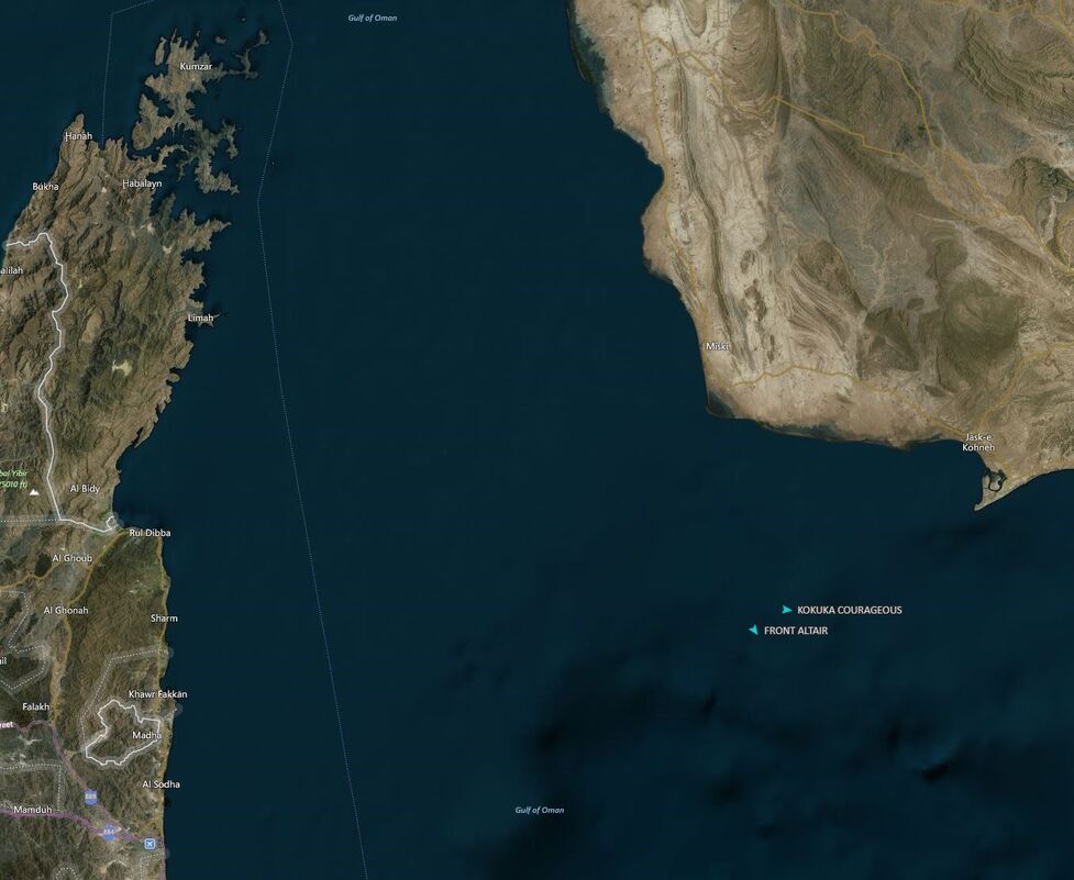
On June 13th two tankers in the Gulf of Oman sent distress calls after they had been damaged by large explosions.
The Front Altair, flagged in the Marshall Islands and owned by Frontline, a Norwegian shipping company, was hauling a cargo of naphtha, an oil derivative, from Abu Dhabi; the Kokuka Courageous, registered in Panama and operated by the Japanese company Kokuka Sangyo, was laden with methanol.
Both were bound for Asian ports.
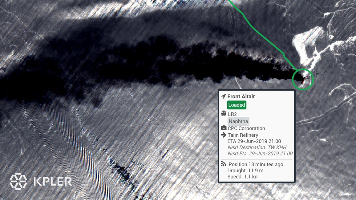
Photos from Iranian news agencies showed a fire burning on the starboard side of the Front Altair.
The plume of black smoke overhead was thick enough to appear in satellite images.
One-fifth of the world’s supply travels through the Strait of Hormuz, an important chokepoint for international shipping.

This is the second time in just over a month that tankers have been damaged in the Gulf.
On May 12th four ships anchored off Fujairah, a port in the United Arab Emirates (UAE), had holes blown in their hulls.
A preliminary investigation suggests that they were damaged by limpet mines.
The latest explosions caused far more damage, forcing crews to evacuate both ships as they were underway.
It will take weeks to probe what happened, amid reports of torpedoes being used.
But the explosions do not seem accidental.
The president of Kokuka Sangyo said the Kokuka Courageous vessel was “attacked” twice in a three-hour period.

image : Kpler
see also Sentinel-2 picture

Nor is it likely that two sets of explosions, weeks apart and in the same area, were mere coincidence.
Though a UAE-led investigative team did not assign blame for last month’s sabotage, it said an unnamed “state actor” carried it out.
America has blamed Iran for both sets of attacks.
Iran, which is a regional rival of the UAE and Saudi Arabia, both American allies, has denied responsibility and hints that the latest explosions were orchestrated by its rivals.
“Suspicious doesn’t begin to describe what likely transpired,” tweeted Iran’s foreign minister, Muhammad Javad Zarif, on June 13th.

courtesy of Spire

Iran has in the past threatened to close the Strait of Hormuz if it were ever attacked.
Some will see the strikes against ships in the area as a veiled warning of its readiness to make good on its threat.
Messrs Zarif and Rouhani probably understand that attacking regional shipping would be to play with fire.
But they do not call all of the shots in Iran.
They are stuck in an internal battle with Iran’s ruling mullahs, who are more distrustful of the West, and their Revolutionary Guards, who back local forces in Syria and Yemen that have fought against Emirati- and Saudi-backed forces.
Iran has a history of irregular warfare that allows it to maintain a measure of plausible deniability.
In the 1980s it fought the so-called tanker war with Iraq.
The conflict ravaged international shipping.

Tensions in the region have been rising since last spring, when Donald Trump withdrew from the deal, signed in 2015, that loosened sanctions on Iran in exchange for limits on its nuclear programme.
Mr Trump reimposed sanctions and added new ones, in effect cutting Iran off from the global economy.
After a year of abiding by the agreement, a bid to win European sympathy, Iran last month said it would begin enriching uranium in excess of the prescribed limits.
Mr Rouhani warned that he would abrogate other provisions unless other signatories—Britain, France, Germany, Russia, China and the European Union—helped his country bypass American sanctions, which is unlikely to happen.
Critics of Mr Trump’s approach have long warned that economic distress would lead Iran to lash out.

For the Arab states across the Gulf, these latest explosions fit into a troubling pattern.
In May, two days after the Fujairah incident, two blasts in the centre of Saudi Arabia, 700km north of the Yemeni border, damaged an oil pipeline that carries crude across the kingdom.
On June 12th a rocket hit the international airport in Abha, a Saudi city 200km from the Yemeni border, injuring 26 people.
Both attacks were carried out by the Houthis, a Shia militia that controls large parts of Yemen and is fighting a Saudi-led coalition there.
A United Nations panel of experts has said that Iran supplied weapons to the Houthis, including drones and missiles, though the group does not always act at Iran's behest.

But Saudi Arabia and its allies have tried not to escalate directly a conflict that would wreak havoc on their oil exports, and thus their economies.
The UAE has been particularly circumspect in its public statements about last month’s sabotage (though in private officials evince little doubt about Iran’s involvement).
If there is to be a response, they would like it to come from America.
Mr Trump’s hawkish national security adviser, John Bolton, has long supported regime change in Iran, and even military action against it.
But the president, as ever, is erratic, toggling between fiery threats and offers of dialogue.
He is reported to have given Mr Abe a message to pass to Iran’s supreme leader, Ali Khamenei (who declined to reply).
“We do not believe at all that the US is seeking genuine negotiations with Iran; because genuine negotiations would never come from a person like Trump,” said Ayatollah Khamenei.

Mr Trump has already bolstered America’s military presence in the region.
Last month he rushed an aircraft-carrier strike group to the region.
Those vessels have not transited the Strait of Hormuz, an effort to avoid further tension.
They will probably step up their patrols; an American destroyer picked up some sailors from the stricken tankers (Iran says it rescued some too).
The Pentagon is deploying an extra 1,500 troops to bases in Qatar, Bahrain and Iraq, and Mr Trump is invoking emergency powers to override congressional objections and sell weapons to Saudi Arabia and the UAE.

All sides insist they do not want war.
But even if they are sincere, good intentions go only so far.
The Gulf states (and their American protector) cannot tolerate threats to shipping.
Mr Abe was right to push for diplomacy between America and Iran.
But his visit, and the events that overshadowed it, underscore how difficult that will be.

Links :

Thursday, June 13, 2019

NOAA upgrades the U.S. global weather forecast model


From NOAA

Improved model will boost weather forecasts across the U.S.

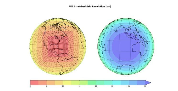
NOAA’s flagship weather model — the Global Forecast System (GFS) — is undergoing a significant upgrade today to include a new dynamical core called the Finite-Volume Cubed-Sphere (FV3).
This upgrade will drive global numerical weather prediction into the future with improved forecasts of severe weather, winter storms, and tropical cyclone intensity and track.

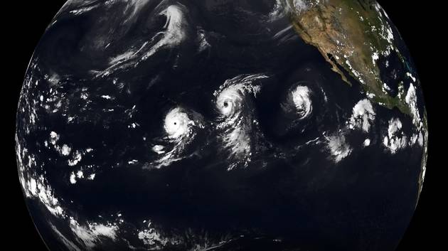
The fine 3 km resolution of the FV3 makes this future simulation of clouds appear as an actual satellite.

NOAA research scientists originally developed the FV3 as a tool to predict long-range weather patterns at time frames ranging from multiple decades to interannual, seasonal and subseasonal.
In recent years, creators of the FV3 at NOAA’s Geophysical Fluid Dynamics Laboratory expanded it to also become the engine for NOAA’s next-generation operational GFS.
“In the past few years, NOAA has made several significant technological leaps into the future – from new satellites in orbit to this latest weather model upgrade,” said Secretary of Commerce Wilbur Ross.
“Through the use of this advanced model, the dedicated scientists, forecasters, and staff at NOAA will remain ever-alert for any threat to American lives and property.”

GFS is now the new version 15.1.1
"FV3-GFS." The name of the new model will not change; it is still GFS.
One way to tell if your provider has updated is to request the parameter REFC, simulated radar reflectivity. This is an excellent parameter for forecasting squalls. 
The US GFS should now be a contender to best global model.

The FV3-based GFS brings together the superior dynamics of global climate modeling with day-to-day reliability and speed of operational numerical weather prediction.
Additional enhancements to the science that produce rain and snow in the GFS also contribute to the improved forecasting capability of this upgrade.

“The significant enhancements to the GFS, along with creating NOAA’s new Earth Prediction Innovation Center, are positioning the U.S. to reclaim international leadership in the global earth-system modeling community,” said Neil Jacobs, Ph.D., acting NOAA administrator.

NOAA will be running the old version of the GFS in parallel for the next 3-months to compare the results

The GFS upgrade underwent rigorous testing led by NOAA’s National Centers for Environmental Prediction (NCEP) Environmental Modeling Center and NCEP Central Operations that included more than 100 scientists, modelers, programmers and technicians from around the country.
With real-time evaluations for a year alongside the previous version of the GFS, NOAA carefully documented the strengths of each.
When tested against historic weather dating back an additional three years, the upgraded FV3-based GFS performed better across a wide range of weather phenomena.

 Upgrade of NOAA's supercomputing system will place it among 30 fastest in world, prepping for next gen Global Forecast System (GFS) next year, which will increase model resolution to 9 km & 128 levels out to 16 days, vs current 13 km & 64 levels out to 10 days.

The scientific and performance evaluation shows that the upgraded FV3-based GFS provides results equal to or better than the current global model in many measures.
This upgrade establishes the foundation to further advancements in the future as we improve observation quality control, data assimilation, and the model physics.

“​We are excited about the advancements enabled by the new GFS dynamical core and its prospects for the future,” said Louis W. Uccellini, Ph.D., director, NOAA’s National Weather Service. “Switching out the dynamical core will have significant impact on our ability to make more accurate 1-2 day forecasts and increase the level of accuracy for our 3-7 day forecasts. However, our job doesn't end there — we also have to improve the physics as well as the data assimilation system used to ingest data and initialize the model.”

Uccellini explained that NOAA’s work with the National Center for Atmospheric Research to build a common infrastructure between the operational and research communities will help advance the FV3-based GFS beyond changing the core.
“This new dynamical core and our work with NCAR will accelerate the transition of research advances into operations to produce even more accurate forecasts in the future,” added Uccellini.

Meanwhile, the world’s most accurate model at the European Center for Medium-range Weather Forecasting received a major upgrade Tuesday, as institutions worldwide endeavor to advance weather prediction.


Operating a new and sophisticated weather model requires robust computing capacity.
In January 2018, NOAA augmented its weather and climate supercomputing systems to increase performance by nearly 50 percent and added 60 percent more storage capacity to collect and process weather, water and climate observations.
This increased capacity enabled the parallel testing of the FV3-based GFS throughout the year.

The retiring version of the model will no longer be used in operations but will continue to run in parallel through September 2019 to provide model users with data access and additional time to compare performance.

Links :


Wednesday, June 12, 2019

Who owns Rockall? A history of disputes over a tiny Atlantic island

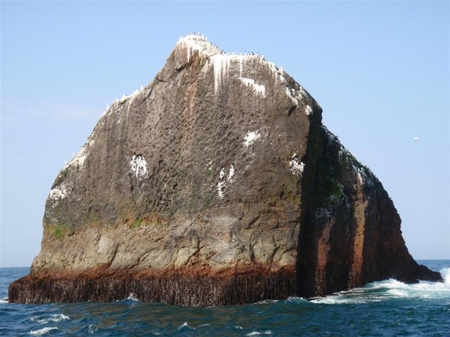
Rockall
Copyright Andy Strangeway cc

From Irish Times

Scotland recently warned Ireland over fishing at Rockall, but the outcrop has long made headlines

Who owns Rockall?
The isolated Atlantic outcrop is in the news after the Scottish government warned Ireland it will send its fisheries patrol vessels to force Irish fishing boats to leave a 12-mile (19km) zone around the tiny disputed island.
But Rockall made headlines long before Friday.

 Rockall with the GeoGarage platform (UKHO nautical chart)

 Atlantic Sea Pilot, 1884

On September 2nd, 1861, the coveted patch 418km (260 miles) west of the Co Donegal coast gained attention on page four of The Irish Times after a letter writer predicted its bountiful waters would yield money “surpassing in value the gold discoveries of California or Australia”.
“I now forward an account of the second return here of Captains Rhodes and Gardener from the new fishing ground at Rockall,” wrote J Dawson, MD.
“They have again made a most successful fishing, having caught between thirteen and fourteen tons of codfish each in about six days’ fishing; while the account they give of the vast numbers of great fish that swarm around that insulated rock in the ocean is even more wonderful than before.”

Rockall has long a generated fierce nationalist rivalries since the first British royal navy expedition scrambled ashore in 1810.
Possession of Rockall, 386km (240 miles) west of the Scottish mainland, was for many decades deemed imperative in order to generate claims to the vast tracts of surrounding fisheries and the oil-rich Atlantic seabed.

Air view the survey ship HMS Vidal with Rockall Island in background. SV.
On deck of Vidal, one of the landing party preparing to take off by helicopter. He is hauled by helicopter from deck.
Voiceover claims: "Rockall is in line with British new rocket range, and since no one else claims it - it's safer in British hands."

The British navy annexed the rock in 1955 by hoisting the Union flag and cementing a brass plaque on its storm-washed summit.
The 1972 Island of Rockall Act, passed by parliament in Westminster, formally declared it to be part of Inverness-shire, even though the nearest permanently inhabited settlement is 367km (228 miles) away on North Uist in the Outer Hebrides.

Irish Governments have not recognised these claims.

British imperial ambitions were set back by international ratification of the UN convention on the law of the sea (Unclos) in 1982, which states that: “Rocks which cannot sustain human habitation or economic life of their own shall have no exclusive economic zone or continental shelf.”

That decision meant ownership of Rockall, which is the eroded rump of an extinct volcano, would no longer be decisive in the international, diplomatic battle for control of the seabed below.

The rules of Uunclos stipulate that coastal states can register claims to the seabed up to 350 nautical miles (648km) offshore.
Claims are ratified by the UN commission on the limits of the continental shelf which sits in New York.

Gain control

The UK made its formal submission for the Hatton/Rockall area in 2009, using the deserted island of St Kilda, inhabited until 1930, as its baseline.
Rockall is 167 nautical miles (309km) to the west of St Kilda.

The UK, however, is not the only state eager laying claim to the the Hatton/Rockall basin.
Ireland, Iceland and Denmark (on behalf of the Faroes) have also lodged overlapping claims.
Consequently, there have been quadripartite talks shuffling between London, Dublin, Reykjavik and Copenhagen for years in an attempt to agree common underwater borders that would allow exploration to start.

Former SAS soldier, Paratrooper and Adventurer Tom McClean is an accomplished and entertaining speaker with many remarkable stories to tell including his famous occupation of the Island of Rockall in the Atlantic

Despite the tortuous negotiations, Rockall retains a symbolic attraction for adventurers.
Tom McClean, an SAS veteran, endured 40 days roped to the outcrop in 1985 in order to assert the UK’s claim.

In 1997, Greenpeace protesters lasted for 42 days as part of a protest against oil exploration.
Underwater reserves of oil, gas and minerals are increasingly eyed by rival nations eager to boost their reserves.

In the most recent chapter in the history of Rockall, Scottish external affairs minister Fiona Hyslop warned the Irish Government that it will deploy its vessels to protect Scottish fishing rights around Rockall.

The Irish Government contests the Scottish claim to the land, as well as the claim to exclusive fishing rights.
In a statement on Friday, the Irish Government said that its position “has been and remains that the waters around Rockall form part of Union waters under the Common Fisheries Policy, to which the principle of equal access for the vessels of all EU Member States applies.
Irish vessels have operated unhindered in the Rockall zone for many decades fishing haddock, squid and other species.”

Tánaiste Simon Coveney said it was the longstanding position of the Government is that Irish vessels are entitled to access the waters around Rockall.
He said: “We have never recognised UK sovereignty over Rockall and accordingly we have not recognised a territorial sea around it either.
We have tried to work positively with the Scottish authorities and to deal with sensitive issues that flow from it in a spirit of kinship and collaboration.
We very much regret that matters have reached this point and intend to do everything possible to achieve a satisfactory resolution.”

Irish people may associate the tiny island with Seán Loftus – who changed his name to Seán Dublin Bay Rockall Loftus – the late TD, former lord mayor of Dublin and life-long environmentalist.
The island also has the distinction of having inspired a rousing republican anthem, Rock on Rockall, by the Wolfe Tones.
The chorus goes: “Oh rock on Rockall, you’ll never fall to Britain’s greedy hands/Or you’ll meet the same resistance that you did in many lands/May the seagulls rise and pluck your eyes and the water crush your shell/And the natural gas will burn your ass and blow you all to hell.”

Links :

Tuesday, June 11, 2019

To map a coral reef, peel back the seawater

The Global Airborne Observatory, a lidar-equipped laboratory designed to map coral reefs from above, flying over St. Croix, U.S. Virgin Islands.
Marjo Aho/The Nature Conservancy

From The New York Times by Paul Tullis

This scientist couple created an airborne observatory to map tropical forests.
Now they’re using it to identify threatened reefs.

Coral reefs comprise just 1 percent of the ocean floor yet they are home to 25 percent of the world’s marine fish, a growing source of protein for people.
But reefs are imperiled by a range of threats including warming waters, acidifying seas, destructive fishing methods, and agricultural and other runoff.

Moreover, scientists have only a rough idea of the extent of reefs worldwide; a reef thought to be 1,000 acres might be 1,500 or just 500.
Of the reefs that have been accurately mapped, little is known about their health, the kinds of fish that live there, or the composition of coral species.

The problem is seawater.
The oceans are vast, making reefs hard to pinpoint, and the water’s surface is difficult for satellite and airborne cameras to see through.

Now, a team of scientists led by Greg Asner and Robin Martin of Arizona State University, has developed a suite of technologies to overcome these obstacles.
The instruments are mounted on a low-flying plane and together make up the Global Airborne Observatory, which effectively can peel back the seawater and map the seafloor to a depth of 50 feet, in three dimensions.
(A huge proportion of the world’s most threatened reefs are in such shallow water, because ocean-warming events mainly occur near the sea surface.)

Mapping Biodiversity from the Air
The Global Airborne Observatory is an airplane packed with sensors that can perform detailed analysis of the underlying terrain.
top : SCANNING FORESTS
The observatory has used a laser scanning technology called lidar to make 3-D maps of forests around the world, including this riverscape in the Peruvian Amazon.
MEASURING BIODIVERSITY
A unique spectral sensor measures wavelengths of light bouncing off the forest canopy to identify distinct tree species, shown here in artificial colors.
middle :
BLOCKED BY SEAWATER
Coral reefs are of great interest to researchers, but most airborne and satellite instruments have difficulty peering through seawater.
This 3-D map shows a Hawaiian bay in natural color.
bottom :
IMAGING CORAL REEFS
The observatory’s sensors are now able to pierce seawater to a depth of 50 feet to create 3-D reef maps, detect coral bleaching and identify different types of coral.
CORAL BIODIVERSITY
Bright colors represent communities of coral in a 3-D map with seawater removed: 
By The New York Times | Images by Greg Asner, Arizona State University Center for Global Discovery and Conservation Science 

Honaunau Bay (Hawaii) with the GeoGarage platform (NOAA nautical chart)

Mapping reefs typically involves swimming with sonars or dragging them behind a boat, which makes for very slow progress.
The Global Airborne Observatory can map 250,000 acres a day, at resolution of 4 centimeters.

“If their methods are good to 50 feet deep, it’s a huge advance,” said Nancy Knowlton, a marine scientist at the Smithsonian Institution’s National Museum of Natural History.
“People who work on coral reefs are so hungry for anything that could help in the conservation realm.”
Dr. Asner, director of Arizona State’s new Center for Global Discovery and Conservation Science, and Dr. Martin, a biochemist and remote-sensing expert, are married.
They worked side by side for years inventing techniques to map tropical forests.
They climbed trees in Madagascar and the Amazon to collect leaf samples, which Dr. Martin would analyze in the lab, to determine their chemical composition.
Later, Dr. Asner would fly over the forests in an early version of the observatory: a small plane outfitted with technology capable of measuring the wavelengths of light — most of it invisible to the human eye — that bounce off the forest canopy.

By linking the trees’ spectral signatures to their chemical makeup, the two scientists created the most detailed maps of forests yet devised.
Their maps have been used in Peru to identify locations for new national parks, and in South Africa to figure out how to improve lion habitat.

Dr. Asner and Dr. Martin are recreational scuba divers, each with thousands of hours of experience underwater.
“We used to keep it separate from the tropical trees career,” Dr. Asner said.
But a few years ago they realized their scientific methods had advanced far enough to be applied to coral reefs.

Greg Asner, of Arizona State University, in the field.
Mapping corals first requires getting close enough to collect samples.
Later, in the lab, the corals’ chemical makeup is matched to their spectral signatures
Credit : Rick Miskiv

“We’re interested in the ecology of all the corals,” Dr. Asner said.
He spoke by phone from a beach on the western side of Hawaii’s Big Island, where he was trying to decide whether the water was calm enough for a dive.
In 2016, the Hawaii governor David Ige announced a plan to protect 30 percent of the state’s reefs by 2030 — the Marine 30x30 Initiative.
This past winter, Dr. Asner and Dr. Martin went there to generate maps of the corals’ health.

Dr. Asner in the airborne observatory.
Twin lasers emit 500,000 pulses of light per second and record the echoes, revealing the location and three-dimensional shape of every object beneath the plane.
Credit : Marjo Aho/The Nature Conservancy

Currently just 12 percent of Hawaii’s waters are under state management.
Last year, the Airborne Observatory mapped reefs in the Caribbean that in 2017 were hit hard by back-to-back hurricanes.
The initial iteration of that map, produced in collaboration with the Nature Conservancy, already has been used to design the largest marine protected area in the Dominican Republic.

“In the forest work, once we got to scale and saw patterns, then we could say something bigger,” said Dr. Martin.
“The reefs community needed that.
We realized the spectroscopy from the plane could help us get there.”

The maps created by Dr. Asner and Dr. Martin reveal refuges of live coral — areas where corals are persisting, to be managed and protected — and the types of seafloor habitat that will support coral nurseries and help accelerate restoration efforts.

Robin Martin, a biochemist and remote-sensing expert at Arizona State.
This past winter, she and Dr. Asner were in Hawaii generating maps of the corals’ health.
Credit : Greg Asner

Mapping corals first requires getting close enough to touch them.
Dr. Asner and Dr. Martin dive to collect samples, and later, back in the lab, determine how the corals’ chemical makeup corresponds to their spectral signatures.

Next, the team searches for those spectra from, on average, several thousand feet overhead.
Cameras detect colors outside the range of human vision that correspond to the chemistry of the corals.
As the chemistry changes with the corals’ health, the cameras pick it up.
Bleaching, which can lead to death, is precipitated by a change in the chemistry that the cameras can see before the bleaching begins to take place.
With this knowledge, interventions can be planned and reefs can be managed.

The suite of tech onboard the Airborne Observatory, now in its third generation, is unique.
Its imaging spectroscopy device, which shows light beyond the visible range, was copied by NASA.
Its lidar instrument works like radar but with light instead of radio waves: Twin lasers emit 500,000 pulses of light per second and record the echoes, revealing the location and three-dimensional shape of every object beneath the plane.
High-resolution cameras collect data at 4-centimeter resolution.
By combining those three methods (with some help from artificial intelligence), Dr. Martin and Dr. Asner made a significant advance in remote mapping.

Each device has different geometries and measurement patterns that must be aligned to make an accurate map, or it would look like a 3-D movie viewed without the glasses.
An inertial motion unit, built by Grumman for use on military warheads, and so sensitive that its location must be reported to the State Department to make sure the technology is handled properly, aligns the images.

Reef-coral polyps of the genus Favia.
Bleaching, which can lead to death, is precipitated by a chemical change that special cameras can detect before the coral bleaches.
Credit : Greg Asner

The flights collect the spectral signature of every pixel, each a mixture of 427 colors.
(Imagine a printer with 427 ink cartridges.)
Back in the lab, deep-learning algorithms can sift the data to determine whether a coral is alive or dead, whether it is bleached (and therefore at risk of death) or on its way to becoming so, and even, in some cases, which species it is.

With the Global (formerly Carnegie) Airborne Observatory, Dr. Asner and Dr. Martin are 6 percent of the way toward building a spectral-chemical library for all 830 known species of coral.
Credit : Greg Asner

In their forest work, Dr. Asner and Dr. Martin have discovered the spectral signatures of 30,000 tree species, almost half the world total.
Now they are about 6 percent of the way toward building a spectral-chemical library for all 830 known species of coral.

“Whereas the pool of species is way lower, this is way harder,” Dr. Asner said.
“I’m after conservation applications that have real efficacy. We have plenty of journal papers.
We’re pushing the scientific community to make their work much more solutions-based, instead of a latency period where things are being researched forever.”

Links :

Monday, June 10, 2019

Towing an iceberg: one captain’s plan to bring drinking water to 4 million people

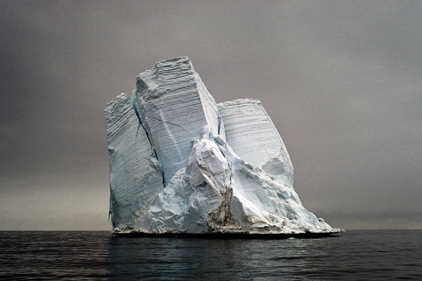
Photographer : Camille Seaman

From Bloomberg by Caroline Winter

Nicholas Sloane doesn’t mind discomfort.
The 56-year-old South African marine-salvage master has survived two helicopter crashes and spent thousands of hours aboard ships that are burning, sinking, breaking apart, or leaking oil, chemicals, or cargo into the ocean.
Often, he gets calls in the middle of the night asking him to pack his bags and fly immediately to a disaster zone across the world, anywhere from Yemen to Papua New Guinea.
Twice, he’s fought off armed pirates using water cannons, sound cannons, and strobe lights.

Usually, Sloane rooms on location, bunking in makeshift beds aboard singed or waterlogged ships he’s working to rescue.
He once lived for three months with a family on Tristan da Cunha, the world’s most remote inhabited archipelago, orchestrating the logistics of catching and washing thousands of rockhopper penguins drenched in bunker fuel from a shipwreck.
More recently, he spent 2½ years overseeing the almost $1 billion refloating of the Costa Concordia, the infamous Italian cruise ship that capsized inside a marine sanctuary off the coast of Tuscany, killing 32 passengers.

But at some point early last year, Sloane really wanted to take a bath and couldn’t.
He was home with his family in Cape Town, which had recently declared an emergency: After three years of severe drought, the city of 4 million was at risk of becoming one of the first in the world to run out of municipal water.
To forestall a shutoff, each household was permitted only 50 liters—about 13 gallons—per day per person to cover drinking, cooking, washing, and showers.
“That’s enough to fill less than half a tub,” says Sloane, a soft-spoken man with graying hair, ruddy skin, and a deep crease between his green eyes.
“My wife used to take a bath every night and a shower every morning.
She told me, ‘You’d better do something.’ ”

 Captain Nick Sloane explains how he plans to tow an ice berg to Cape Town

More than a year later, disaster has been averted, thanks to badly needed rainfall and drastic reduction in water use.
But conditions in Cape Town remain far from normal.
The daily-use limit has been raised, but only to 70 liters, and people still take speed showers, collecting the runoff to use for toilet flushing.
Some hotels have removed stoppers from bathtubs to keep profligate tourists in line.
And farmers throughout the country are reeling.
More than 30,000 seasonal jobs have been lost in the Western Cape, and crop production has declined by about 20%.
During the height of the drought, hundreds of farmers in the Northern Cape killed off most of their livestock rather than truck in costly feed.
“Everyone has cut back their flocks of sheep to the bare minimum needed to start again when it rains,” one farmer told Bloomberg News in 2017.

Sloane still hasn’t taken that bath at home, and he isn’t optimistic about Cape Town’s future.
“We’ll never get back to the days where water is flowing all over the Cape,” he says, pointing out that the city’s population has grown almost 40% in the last 20 years.
“If the taps run dry, the first day people will be standing in lines at watering points throughout the city.
The second day, if you don’t get your water, well, people are killed for that.”

That’s why Sloane is working on a solution that might sound absurd.
Making use of his unusual skill set, he plans to harness and tow an enormous Antarctic iceberg to South Africa and convert it into municipal water.
“To make it economically feasible, the iceberg will have to be big,” Sloane says.
Ideally, it would measure about 1,000 meters (3,281 feet) long, 500 meters wide, and 250 meters deep, and weigh 125 million tons.
“That would supply about 20% of Cape Town’s water needs for a year.”
Sloane has already assembled a team of glaciologists, oceanographers, and engineers.
He’s also secured a group of financiers to fund the pioneer tow, which he calls the Southern Ice Project.
The expected cost is more than $200 million, much of it to be put up by two South African banks and Water Vision AG, a Swiss water technology and infrastructure company.
Now Sloane’s team needs an agreement with South Africa to buy the Antarctic water, if the plan succeeds.
His team could charter the necessary ships and prepare all required materials within six months, though the mission will need to take place in November or December, when the Antarctic climate is somewhat less ferocious.
“We’re taking on all the risk,” he says.
“We’re ready to go.”

Harvesting icebergs isn’t a new idea.
In the mid-1800s, breweries in Chile towed small ones, sometimes outfitted with sails, from Laguna San Rafael to Valparaiso, where they were used for refrigeration.
In the late 1940s, John Isaacs of the Scripps Institution of Oceanography began exploring more fantastical plans, such as transporting an 8 billion-ton iceberg to San Diego to mitigate California droughts.
(Icebergs of the size Isaacs had in mind—20 miles long, 3,000 feet wide, and 1,000 feet deep—are extremely rare.)
In the ’60s oil companies began using thick ropes to wrangle and redirect much smaller Arctic icebergs before they collided with rigs, a practice that’s now common.
If conditions are too rough, or a berg too big, the rigs sometimes need to be moved instead.

In the ’70s, the U.S. Army and the Rand Corp. both looked into using Antarctic ice as a source of fresh water.
At about the same time, Prince Mohammed al-Faisal began pouring funds into polar research, in hopes that his assembled team of international glaciologists and engineers would find a way to alter the drift of icebergs, potentially bringing them as far as Western Australia.
Prince Mohammed even sponsored the First International Conference on Iceberg Utilization for Fresh Water Production, Weather Modification and Other Applications in, of all places, Ames, Iowa, in 1977 and had a miniberg weighing 4,800 pounds trucked in from Alaska.
“The people of Ames have seen princes before, but it has been many millenniums since an iceberg has visited these parts,” wrote the New York Times, delighting in the spectacle.
The paper also described some of the more outlandish suggestions floated by speakers, such as outfitting icebergs with nuclear-powered paddle wheels that would allow them to “be propelled as self-contained units.”
One skeptical delegate lamented: “There isn’t much money around these days for Arctic and Antarctic research, so they’ve flocked around like flies to the honey pot.
It’s embarrassing.”
Eventually, Prince Mohammed stopped funding polar research, but attempts to access iceberg water continued.

Today, in Newfoundland, a handful of small Canadian companies, including one called Iceberg Vodka, hire so-called iceberg cowboys, who use chainsaws, articulated claws, and even rifles to take off chunks of passing Arctic bergs, so they can be netted, melted, and used to distill premium alcohol.
(Icebergs form from compacted snow, and their water is uncommonly pure.)
This spring thieves made off with 8,000 gallons of Iceberg Vodka’s water, siphoning it from a large tank.
“Our suspicion is that whoever took it thought it was vodka,” said Chief Executive Officer David Meyers.
Berg Water, another Newfoundland company, sells 12-packs of “15,000-year-old” water for as much as $180.

More urgently, interest is being fueled by the world’s increasingly dire shortages of fresh water.
Today, as many as 2.1 billion people worldwide lack access to safe drinking water, according to the World Health Organization, and the United Nations says global water demand will outstrip supply by 40% as soon as 2030.
The problem is the result of poor government oversight, fracking, pollution, and failing infrastructure.
Even in the U.S., leaks and theft account for an estimated loss of 16% of fresh water, writes David Wallace-Wells in The Uninhabitable Earth: Life After Warming.
In Brazil and other places, the loss is as high as 40%.
There’s no magic fix.
Desalination is a poor solution—it’s expensive and energy-intensive and produces more chemical-laced brine than potable water.
Much of that brine, which is extra-salty and contains potentially harmful substances necessary for the desalination process, including copper and chlorine, is pumped back into the ocean.
There, its density causes it to sink to the ocean floor, where it depletes oxygen and destroys marine life.

According to a 2019 UN report, global desalination plants already produce 51.8 billion cubic meters of brine annually, enough to cover the entire state of Florida a foot deep.
Last year a study of almost 180,000 people in Israel linked desalinated water to a 6% to 10% increase in heart disease.
Plus, it tastes terrible.

Meanwhile, more than 100,000 Antarctic icebergs melt into the ocean each year.
They range from merely large to country-size (the biggest seen recently was the size of Jamaica), and by some calculations they contain more than the annual global consumption of fresh water.
Rather than let that water slip away, several groups are vying for berg-towing funds and know-how.
The European Union in 2010 received a proposal to pull icebergs from Newfoundland to the Canary Islands, which have long been short on fresh water; and the United Arab Emirates plans to test its prospects of importing icebergs by bringing one from the Antarctic to Australia or Cape Town by late 2020.

In Germany, a company called Polewater Gmbh says it’s spent $2.8 million over the past six years hiring experts to complete a strategy for getting Antarctic iceberg water to drought-stricken areas, with an emphasis on minimizing environmental impact.
Having won the blessing of some Greenpeace officials, Polewater says it needs $67 million to build the company over the next three years.

Towing a Berg

Data: Collecte Localisation Satellites, Natural Earth, Olav Orheim
But when it comes to towing a 100 million-ton iceberg through the notoriously rough Antarctic Ocean, where swells regularly reach 15 meters, investors are betting on Sloane.
“I was the greatest skeptic around,” says Bert Mulder, chief operating officer of Water Vision, Sloane’s Swiss backer.
“Then I started to listen to Nick Sloane. If anybody can do it, it’s him. I truly believe that.”

Sloane was born in Northern Rhodesia, now Zambia, and grew up exploring rivers and lakes.
“There was no TV, only basic radio, so the outdoors was your life,” he says.
At about 10 he moved with his family to a town outside Durban, South Africa, where he began sailing and found he loved ocean racing in stormy weather, particularly because daring counted for more than tactics alone.
After high school, he completed his national service with the merchant marine, then spent 10 years becoming a master mariner, running tankers and cargo ships and towing oil rigs.
From there, he stumbled into the high-intensity work of marine salvage, where successful teams are rewarded with payouts of 7.5% to 10% of the distressed ship’s assessed value, a fee that often reaches millions of dollars.
Today, Sloane spends roughly six months of the year in Cape Town with his wife and three kids.
But he’s always on call for his employer, Resolve Marine Group, a global salvage company based in Florida.
From one day to the next, he might find himself rappelling from a helicopter onto a burning supertanker or using his connections and organizational skills to oversee the complicated logistics of cleaning up a toxic spill in remote waters.

The iceberg is Sloane’s side project, and he’s enlisted perhaps the biggest names in the game.
The first is Georges Mougin, the French engineer whom Prince Mohammed tapped as CEO of his company, Iceberg Towing International.
Now 91 years old with bushy eyebrows—but still sharp and a dapper dresser—Mougin has spent much of the past four decades exploring the technologies and materials to be used for iceberg transport.

The second is Olav Orheim, trim and energetic at 77, who served as director of the Norwegian Polar Institute from 1993 to 2005.
Orheim has probably landed atop more icebergs than anyone in the world and once was stranded overnight on one with David Attenborough, the English broadcaster and voice of the nature series Planet Earth.
Together with oceanographers and engineers from Norwegian and South African universities and from government-affiliated institutes such as the Pretoria-based Council for Scientific and Industrial Research, Sloane’s team began forging a plan and soon attracted press coverage.
“Unfortunately, the first article came out on April 1,” Sloane says.
“People still think it’s an April Fools’ joke.”
The team is focused only on Antarctic icebergs, which break off from the giant sea shelf that extends from the southern continent’s landmass.
These are often hundreds of times bigger than Arctic icebergs, and the biggest are almost always tabular and therefore more stable.
By contrast, Arctic icebergs, most of which descend from Greenland’s steep glaciers, are typically irregular and contain weak spots that make them liable to split or flip.

Using satellite data, the team will identify an iceberg that’s the right size and shape and on a course for Gough Island, a tiny landmass halfway between Antarctica and Cape Town—about 1,600 miles from Sloane’s final destination.
(There are typically three or four desirable bergs available on any given day.)
Next, they’ll inspect the iceberg on location, using sonar and radar scans to determine its precise dimensions and check for structural flaws.
If everything looks good, the team will employ two tugboats to encircle the berg in a gigantic net of 5-inch-diameter ropes fashioned from Dyneema, a supermaterial that, unlike metal cables, is neutrally buoyant and also stronger and better suited for low temperatures, friction, and tension.
Costing about $25 million, the net will extend about 2 miles across and 60 feet high.
It will act as a kind of belt around the belly of the iceberg, which could reach more than 70 stories below the surface of the ocean.
All this will be done amid high waves and winds reaching 80 mph.
“It’s the worst part of the ocean worldwide,” Sloane says.
“People don’t go there unless they have to.”

With the net in place, the iceberg will be attached to two supertankers at a distance of about a mile.
The tankers, which will remain about 1,000 feet from one another, will move at about 1 mph.
Because they’ll have little ability to steer at such low speeds, each tanker will be led by tugboat.
The operation will need to be insured by Lloyd’s of London in case the iceberg breaks apart en route, leaving dangerous debris in the path of other ships.
The goal will be to follow the Antarctic Circumpolar Current eastward and then, at the right moment near Gough Island, deploy full force to switch over to the Benguela Current, which will bring the iceberg upward toward South Africa’s western coast.
“If we hit the wrong current, that’s it,” Sloane says.
“Then we’ll have to call up the Aussies and say, ‘Do you want to buy an iceberg?’ ”
Traveling “slower than the slowest thing on Earth,” as Sloane puts it, the journey will take an estimated 80 to 90 days.

Sloane and Mougin aim to wrap the icerberg in a fabric mesh that could prevent it from melting (Credit: Georges Mougin & Nick Sloane)

The anticipated melt rate is about 0.05 meters to 0.1 meters per day from each side and the base, which would result in a reduction in size of about 8% by arrival—but certain factors, most notably storms, could increase erosion at the water line.
The final destination will be northwest of Cape Town, where the iceberg will run aground and sit amid the fairly cold, slow-moving Benguela Current, about 25 miles from land.
There, Sloane’s team will hold the berg in place with a 1,000-ton mooring system, and, like the French artist Christo, wrap the entire underwater portion in a giant, 800-ton geotextile skirt designed to reduce wave impact and inhibit further melting.
The skirt, expected to cost roughly $22 million, will let fresh water pass through, creating a buffer of cold water, while keeping salt water out.
As the iceberg gets smaller, it will be moved closer to shore.

To harvest the water, the team will ship earthmoving equipment, including grading and milling machines, to the iceberg via barge.
The machines will be used to excavate a shallow saucer, which will help speed melt to anywhere from 60 million to 150 million liters a day of an icy slurry.
The slush will be pumped into a rotating fleet of grocery-grade container ships.
Back on land, the slurry will be fed into a temporary pipe system and mixed with water from municipal reservoirs.
Sloane believes the iceberg could supply Cape Town for a year before it becomes unstable and breaks apart.
This, he says, will likely happen once the berg is reduced to about 30% of its original size—though it’s impossible to know for sure.
“Nobody’s tried this, so there are going to be unexpected discoveries,” he says.
Before even attempting the tow, the team will need a few months to perform a reduced environmental assessment for the government—reduced because Cape Town is still in crisis.

One problem may be the effect of parking a giant ice cube off Africa’s coast.
“We have no idea what such a thing would do to all the atmospheric, oceanic ecosystem dynamics in the area,” says Marcello Vichi, a professor of oceanography at the University of Cape Town who’s collaborating with Sloane’s team but has some reservations.
“We’d need to do a lot more research, but that’s where money comes in, and time.” Alan Condron, who works at the Massachusetts-based Woods Hole Oceanographic Institution and joined the project in May, will begin modeling impacts within the next months.
He also plans to model melt rates and various towing routes, as well as the carbon footprint of hauling icebergs vs. desalination.
But there’s a limit to what these projections can achieve, he says.
“At some point, you can throw all the modeling you have at it, but you just need someone to go out and do it.”

The price of delivering Antarctic water will be perhaps the biggest obstacle—Sloane says it would cost Cape Town about three times what it now pays for delivery of surface water.
Critics within the Cape Town government say it would cost substantially more.
“This proposal was not considered suitable for Cape Town,” says Xanthea Limberg, a member of the mayoral committee for water and waste services.
“Such a project is both complex and risky with an anticipated very high water cost.
The greatest challenges pertained to containment and transportation of the melt water as well as its injection into the water supply system.”
Other officials say the world’s worsening water crisis, along with South Africa’s booming population and the local impact of climate change, require looking beyond traditional water sources.
“We do not have the luxury to discard options,” says Dhesigen Naidoo, CEO of South Africa’s Water Research Commission, a nonprofit funded by the country’s water tax.
“An iceberg is 99% pure water, and you have the prospect of that sitting on your doorstep in a giant chunk that you can tap into.
It’s a terrific idea.”

Time is running out for South Africa to order an iceberg for delivery this year.
Instead, politicians will likely pray for rain, which is frustrating for Sloane’s backers.
“We silently sometimes think, A little more drought could bring the project closer,” says Mulder of Water Vision.
“But at the same time, you wish the best for the people in Cape Town and that abundant rainfall comes.”
In early April, Sloane jets to Paris to visit Mougin and Orheim, who both live there.
Dressed in a well-cut blue suit and brown leather dress boots, he looks like any other businessman, but for the Oakley sunglasses hanging from a cord around his neck and his Thule briefcase, which is worn to the point of shredding in one corner.
Over the previous month, he’s been to England, Japan, and Mozambique for salvage work.
“I thought I was going to have to attend to a shipwreck in Yemen, but it worked out that I could come here,” he says.
Sloane has put more than $100,000 of his own money into the Southern Ice Project.
“If you’d asked me 10 years ago, I probably would have said this was crazy, but now the time is right,” he says, sitting in the lounge at the InterContinental Paris Le Grand Hotel, where he’s staying.
Cape Town, he points out, is by far the most conveniently located city for a pioneer tow, given its relative proximity to Antarctica and the path of the Benguela Current, but he believes icebergs may eventually be pulled to Perth, Australia, and Santiago, Chile.
“And if you can get it to Cape Town, you can get it to Namibia and maybe as far as Angola.”
For now, Sloane is focused entirely on his continent, where cities and towns across several nations are running dry.
“I promise you, the water situation in some parts of Africa is getting worse all the time.
It’s certainly not getting better,” he says.
“Twenty or 30 years from now, I think towing icebergs will be a regular thing.”

Links :

Sunday, June 9, 2019

First you make the maps

Superb story Map by Elizabeth Della Zazzera made on Lapham's Quaterly
on the relationship between mapping and the development of maritime trade.
 A fantastic historical introduction to nautical maps and the essential cartographic breakthroughs that made global trade (and colonialism/imperialism) possible
Visit :
www.laphamsquarterly.org/trade-maps/index.html

From the fifteenth to the eighteenth century, European powers sent voyagers to lands farther and farther away from the continent in an expansionist period we now call the Age of Exploration.
These journeys were propelled by religious fervor and fierce colonial sentiment—and an overall desire for new trade routes.
They would not have been possible without the rise of modern cartography.
While geographically accurate maps had existed before, the Age of Exploration saw the emergence of a sustained tradition of topographic surveying.
Maps were being made specifically to guide travelers.
Technology progressed quickly through the centuries, helping explorers and traders find their way to new imperial outposts—at least sometimes.
On other occasions, hiccups in cartographic reasoning led their users even farther astray.