JeffHK, who regularly makes videos about sailing, wanted to show off heavy weather. And not the dramatic kind, like the stuff in The Perfect Storm.
Just regular bad weather, which he compares to being in flight turbulence for twenty-four hours a day.
The experience ultimately sounds unpleasant, but watching Jeff and the crew prepare for it—by tying chairs together or making sure every mug is in its place—will give you a feel for the real work of sea travel even with your feet on solid ground.
Earth does not always spin on an axis running through its poles. Instead, it wobbles irregularly over time, drifting toward North America throughout most of the 20th Century (green arrow).
That direction has changed drastically due to changes in water mass on Earth.
The ground we stand on is not as steady as it seems. There are a host of
factors that cause the entire Earth to judder and topple
The Earth beneath our feet seems reassuringly solid and unchanging
most of the time.
But this is an illusion, born of our limited
perspective.
Our planet rotates on its axis once every 23 hours,
56 minutes and 4 seconds.
It also orbits the Sun, while our Solar System
dashes around the centre of the Milky Way, which is itself hurtling
across the Universe towards a region of space called the Great
Attractor.
The speeds involved are frankly dizzying.
Even if you
ignore all that, the Earth is far from stable.
Beneath us, enormous
chunks of rock are constantly grinding past each other to make valleys,
pushing together to form mountains, or dragging apart to create rivers
and oceans.
The ground under us is forever shifting, stretching and
wobbling.
Most of the time, this is nothing to worry about.
However, our growing understanding of these phenomena is driving a
better understanding of the inner workings of our planet.
It is also
handy for anyone trying to track and land spacecraft.
Here, then, are
seven things that make the Earth move for us.
Before about 2000, Earth's spin axis was drifting toward Canada (green arrow, left globe).
JPL scientists calculated the effect of changes in water mass in different regions (center globe) in pulling the direction of drift eastward and speeding the rate (right globe).
Credit: NASA/JPL-Caltech
Under pressure
A desktop
globe is a perfect sphere, so it spins smoothly around a fixed axis.
However, the Earth is not spherical, and the mass within it is both
unevenly distributed and prone to moving around.
As a result, the axis
around which Earth spins, and the north and south rotational poles at
each end of the axis, move about.
What's more, because the
rotation axis is different to the figure axis around which its mass is
balanced, the Earth wobbles as it spins.
This wobble was predicted by scientists as far back as Isaac Newton.
To be more precise, it is made up of a number of distinct wobbles.
The one that has the greatest impact is known as the Chandler Wobble, first observed by American astronomer Seth Chandler Jr in 1891.
It causes movements of the poles of around 26ft (9m) and takes some 14 months to complete a full cycle.
During
the 20th Century scientists suggested a wide variety of causes,
including changes in continental water storage, atmospheric pressure,
earthquakes, and interactions at the boundary of the Earth's core and
mantle.
Geophysicist Richard Gross
of NASA's Jet Propulsion Laboratory (JPL) in Pasadena, California
solved the mystery in 2000.
He applied new weather and oceanic models to
observations on the Chandler Wobble from 1985-1995.
Gross calculated
that two-thirds of the Wobble was caused by fluctuating seabed pressure, and one-third by changes in atmospheric pressure.
"Their
relative importance varies with time," says Gross, "but the cause is
now widely accepted to be the combination of changes in atmospheric and
oceanic pressures."
The relationship between continental water mass and the east-west wobble in Earth's spin axis. Losses of water from Eurasia correspond to eastward swings in the general direction of the spin axis (top), and Eurasian gains push the spin axis westward (bottom).
Credit: NASA/JPL-Caltech
Water works
The seasons are
the second largest influence on the Earth's wobble.
That is because they
cause geographical variations in the amount of rain, snow and humidity.
Scientists
have been able to pinpoint the poles using the relative positions of
the stars since 1899, and using satellites since the 1970s.
But even
after removing the impact of the Chandler and seasonal wobbles, the
north and south rotational poles still move about with respect to the
Earth's crust.
In a study published in April 2016, Surendra Adhikari and Erik Ivins, also at JPL, identified two more important pieces of the Earth wobble jigsaw.
Before
the year 2000, the Earth's spin axis was drifting towards Canada, a few
inches per year.
But then measurements show the spin axis changed tack,
heading instead towards the British Isles. Some scientists suggested
this could be the result of the loss of ice caused by the rapid melting
of Greenland's and Antarctica's ice sheets.
Adhikari and Ivins set out to test this idea.
They compared GPS measurements of the positions of the poles with data from GRACE, a study that uses satellites to measure changes in mass around the Earth.
They
found that the melting of the Greenland and Antarctic ice sheets only
explains around two-thirds of the recent shift in the direction of the
poles.
The remainder, they concluded, is down to the loss of water held
on continents, mostly the Eurasian land mass.
This region has been affected by aquifer depletion
and drought.
Then they factored in the position of the areas affected. "From the
fundamental physics of rotating objects, we know that movement of the
poles is highly sensitive to changes at [around] +/- 45 degree
latitudes," says Adhikari. That is exactly where Eurasia had lost water.
The study also identified continental water storage as a plausible explanation for another wobble in the Earth's rotation.
Throughout
the 20th Century, researchers were puzzled because the spin axis
shifted every six to 14 years, heading 0.5-1.5m east or west of its
overall drift. Adhikari and Ivins found that, between 2002 and 2015, dry
years in Eurasia corresponded to the eastward swings and wet years
corresponded to westward movements.
"We found a perfect match,"
says Adhikari. "It's the first time anyone successfully identified a
one-to-one match between the global-scale inter-annual wet-dry
variability and inter-annual polar motion."
This video explains what's happening to Earth
Man-made meandering
While
these movements of water and ice are caused by a combination of natural
processes and human actions, other changes that impact the Earth's
wobbling are all our own doing.
In a 2009 studyFelix Landerer,
also of the JPL, calculated that, if carbon dioxide levels double
between 2000 and 2100, the oceans will warm and expand in such a way
that the north pole will shift around 1.5cm per year towards Alaska and Hawai'i over the next century.
Similarly, in a 2007 study
Landerer modelled the effects of the ocean warming caused by the same
carbon dioxide increase on ocean bottom pressures and circulation.
He
found that the changes would shift mass to higher latitudes, and that
this would shorten the day by a little over 0.1 milliseconds: 1/10,000th
of a second.
Quake shake
It is not just
large volumes of water and ice that affect the Earth's rotation if they
move around. Shifting rocks have the same effect, if they are big
enough.
Earthquakes occur when the tectonic plates that make up
the Earth's surface slip past each other suddenly. In theory, that could
make a difference.
However, at first the amount of water involved seemed too
small to have such an impact.
For example, Gross studied the massive 8.8-magnitude quake that hit the coast of Chile in 2010.
In as as-yet-unpublished study, he calculated that the plate movements shifted Earth's axis of mass balance by around 8cm.
However,
this was only a model-based estimate.
Gross and others have since
attempted to observe real shifts in the way the Earth is spinning, by
following earthquakes in GPS satellite data.
So far this has
proved unsuccessful, because it is tricky to remove all the other things
that influence how the Earth rotates.
"The models are not perfect and
there is residual noise masking the smaller earthquake signals," says
Gross.
The movements of mass that take place when tectonic plates
slip past each other also affect the length of days.
This is a little
bit like an ice skater spinning on one spot: she can speed up by drawing
her arms in and thus shifting her mass closer to her body, or slow down
by doing the opposite.
For example, Gross calculated that the magnitude-9.1 earthquake that hit Japan in 2011 shortened the length of the day by 1.8 microseconds.
Storm force wobble
When an earthquake happens, it triggers seismic waves that carry its energy through the interior of the Earth.
There are two kinds. "P-waves" repeatedly squeeze and expand the
material they pass through, with the vibrations travelling in the same
direction as the wave.
Slower "S-waves" wobble rock from side to side,
with the vibrations occurring at right angles to their direction of
travel.
Intense storms can also create faint seismic waves like
those triggered by earthquakes.
These waves are called microseisms.
Until recently, scientists have been unable to determine the sources of
S-waves from microseisms.
In a study published in August 2016, Kiwamu Nishida of the University of Tokyo and Ryota Takagi
of Tohoku University reported that they had used a network of 202
detectors in southern Japan to track both P- and S-waves.
They traced the waves' origins to a severe North Atlantic storm called a "weather bomb": a storm in which the atmospheric pressure at the centre drops unusually rapidly.
Tracking microseisms in this way will help researchers to better understand the internal structure of the Earth.
Lunar influence
It is not
just Earth-bound phenomena that influence our planet's movements.
Recent
research suggests that large earthquakes are more likely around full
and new moons.
That could be because the Sun, Moon and Earth are
aligned, increasing the gravitational force acting on our planet.
In a study published in September 2016, Satoshi Ide
of the University of Tokyo and his colleagues analysed the tidal
stresses in the two-week periods prior to large earthquakes in the last
two decades. Of the largest 12 earthquakes, all of which had a magnitude
of 8.2 or higher, nine happened close to full or new moons.
No such relationship was found for smaller quakes.
Ide
concluded that the extra gravitational force exerted at these times
could increase the forces acting on tectonic plates.
The changes would
be small, but if the plates were under stress anyway, the extra force
could be enough to turn small rock failures into larger ruptures.
While this may seem plausible, many scientists are sceptical because Ide's study only looked at 12 earthquakes.
Sun shakes
Even more
controversial is the idea that vibrations originating deep within the
Sun could help explain a number of shaking phenomena on Earth.
When
gases move around inside the Sun, they produce two different types of
waves.
Those generated by changes in pressure are called p-modes, while
those that form when dense material is pulled downwards by gravity are
called g-modes.
A p-mode takes a few minutes to complete a full
vibrational cycle, while a g-mode takes between tens of minutes and
several hours.
This amount of time is the mode's "period".
In 1995, a group led by David Thomson
of Queen's University in Kingston, Canada analysed patterns exhibited
by the solar wind – a stream of charged particles that flows out from
the Sun – between 1992 and 1994.
They reported fluctuations that had the same periods as p-modes and g-modes, suggesting these solar vibrations were somehow influencing the solar wind.
In
2007, Thomson went on to report that unexplained fluctuations in the
voltages of undersea communications cables, seismic measurements on
Earth and even mobile phone call dropouts also had frequency patterns that matched the waves inside the Sun.
However,
other scientists believe Thomson's claims are on shaky ground.
According to simulations, these solar vibrations, especially the
g-modes, should be so weak by the time they get to the Sun's surface
that they could not affect the solar wind.
Even if that is not the case,
the patterns should be destroyed by turbulence in the interplanetary
medium long before they get to Earth.
"When we looked at different
time periods, the frequencies he had identified were shifting around,
when to be g-modes in particular they should remain fairly constant,"
says Pete Riley of Predictive Science in San Diego, California.
Back in 1996 he published a study
questioning Thomson's original results.
"We looked at the same data
Dave Thomson looked at and applied the same analysis, and couldn't find
any evidence for p-modes or g-modes."
Clearly, Thomson's idea might not pan out.
But there are plenty of other reasons why our planet wobbles and shakes.
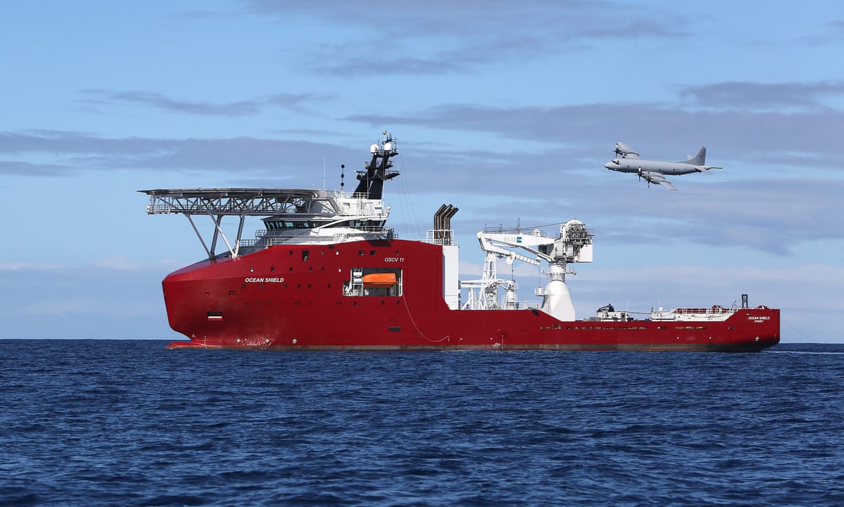
A Royal Australian Air Force AP-3C Orion flies past the Australian
vessel Ocean Shield on a mission to drop sonar buoys to assist in the
search for MH370.
Australia’s Transport Safety Bureau reveals it is ‘confident’ aircraft not in underwater zone that has been explored so far
The Australian authorities leading the search for MH370 have a “high
degree of confidence” that the plane’s wreck is not to be found in the
expanse of Indian ocean they have spent more than two years searching.
The Australian Transport Safety Bureau (ATSB) on Tuesday released the
findings from its MH370 First Principles Review summit of crash
investigators, aviation experts and government representatives, held in
Canberra over three days from 4 November.
The Australian-led search effort of 120,000 sq km of the southern
Indian ocean, informed by satellite data, has cost $145m (£117m) and is
due to end in January.
Fewer than 10,000 sq km remain to be searched,
though progress has been slowed by bad weather.
But experts meeting in Canberra to reassess existing evidence and
analysis say they are now confident the wreck of the plane is not there.
“There is a high degree of confidence that the previously identified
underwater area searched to date does not contain the missing aircraft.”
New analysis of the satellite data, combined with drift analysis, has
identified the most likely point that MH370 hit the water as being
close to the so-called “seventh arc”, north of the current search zone.
In April, the ATSB commissioned the Commonwealth Scientific and
Industrial Research Organisation (CSIRO) to perform a detailed study of
the drift of recovered debris.
Its findings were also released on Tuesday, and served to narrow down the possible point of impact of the plane.
The newly identified area of interest in the Indian Ocean (orange)
lies to the north of the current one (purple).
The CSIRO’s findings were reinforced by the timing and location of
where confirmed debris of the plane has been found: in the western
Indian Ocean and on the east coast of Africa.
Experts have identified a new area of approximately 25,000 sq km –
between latitudes 33 degrees south and 36 degrees south – as “the area
with the highest probability of containing the wreckage of the
aircraft”, given the 110,000 sq km that have been eliminated.
“The experts concluded that, if this area were to be searched,
prospective areas for locating the aircraft wreckage, based on all the
analysis to date, would be exhausted.”
Whether the new prospective search will be carried out is dependent on funding from Australia, Malaysia and China, the three governments involved in the search effort.
A spokesman for the ATSB told Guardian Australia that the attendees
of the first principles review summit “were not parties empowered to
make decisions about any future search efforts”.
The report had been
provided to the three governments “for their consideration”.
“If we are unable to locate the aircraft in the current search area,
this new area represents the next most likely area to contain the
aircraft.”.
How much it would cost to search the new 25,000 sq km area had not been determined, he said.
In July, the three transport ministers had agreed that, in the
absence of credible new evidence, the search for MH370 would be
suspended indefinitely upon the completion of the effort currently
underway.
The Australian transport minister, Darren Chester, seemed to downplay
the likelihood of the search being extended in a statement which
reiterated the resolution of the tripartite meeting in July and said the
report did “not give a specific location of the missing aircraft”.
“We are very close to completing the 120,000 sq km underwater search
area, and we remain hopeful that we will locate the aircraft,” he said.
He repeated the decision made in July that the search would be
suspended “unless credible evidence is available that identifies the
specific location of the aircraft”.
The Malaysian transport minister, Datuk Seri Liow Tiong Lai, said it
remained to be seen how the ATSB report could be used to help identify
the aircraft’s specific location.
“I wish to reiterate that the aspiration to locate MH370 has not been
abandoned and every decision made has and will always be in the spirit
of cooperation among the three nations.”
The third anniversary of the plane’s disappearance from Kuala Lumpur
to Beijing will be on 8 March 2017.
The ATSB began searching the 120,000
sq km area in October 2014.
President Barack Obama on Tuesday moved to indefinitely block drilling in vast swaths of U.S. waters.
The president had
been expected to take the action by invoking a provision in a 1953 law
that governs offshore leases, as CNBC previously reported.
The law allows a
president to withdraw any currently unleased lands in the Outer
Continental Shelf from future lease sales.
There is no provision in the
law that allows the executive's successor to repeal the decision, so
President-elect Donald Trump would not be able to easily brush aside the action.
Trump has vowed to open more
federal land to oil and natural gas production in a bid to boost U.S.
output.
Obama on Tuesday said he would designate "the bulk of our Arctic
water and certain areas in the Atlantic Ocean as indefinitely off
limits to future oil and gas leasing, though the prospects for drilling
in the affected areas in the near future were already questionable.
The White House also indicated Canada will take measures to prevent oil and gas exploration in its waters.
"These actions, and
Canada's parallel actions, protect a sensitive and unique ecosystem that
is unlike any other region on earth," Obama said in a statement.
"They reflect the
scientific assessment that, even with the high safety standards that
both our countries have put in place, the risks of an oil spill in this
region are significant and our ability to clean up from a spill in the
region's harsh conditions is limited."
The action
potentially tees up a battle that touches on hot-button issues:
environmental protection, energy independence, climate change, and the
scope of executive power.
Like other efforts by
the Obama administration to advance environmental protection through
executive action, it could also be challenged in the courts.
It could
get tied up there throughout much of Trump's four-year term.
The Republican-controlled Congress could also try to change the law.
The provision,
contained in the 1953 Outer Continental Shelf Lands Act, has been
invoked in the past to set aside smaller portions of the Outer
Continental Shelf, such as coral reefs or natural habitats. Presidents
George H.W. Bush and Bill Clinton used the provision to block drilling in much of the Outer Continental Shelf, but for limited periods.
Oil drilling platform heritage
(Credit: Glenn Beltz/Flickr)
The Obama
administration's action marks the broadest use of the statute ever
because it would be far-reaching in terms of the lands it would protect
and come without an expiration date.
Provision 12(a) of
the law states, "The President of the United States may, from time to
time, withdraw from disposition any of the unleased lands of the outer
Continental Shelf."
Momentum to use the
provision has been building this year. In May, a coalition of
environmental groups circulated a fact sheet that highlighted the
authority provided under 12(a).
In September, Democratic Congress members Frank Pallone, Jr. and Jared Huffman sent a letter to Obama urging him to exercise that authority.
The letter was signed by 74 lawmakers, almost all Democrats, and
contained quotes from representatives from some of the groups that
produced the fact sheet in May.
Environmentalists say
drilling in the Arctic and Atlantic puts the waters at immediate risk,
for oil and gas that would not come online for years, after a transition
to cleaner energy sources could be under way.
The White House
echoed that sentiment on Tuesday, saying, "it would take decades to
fully develop the production infrastructure necessary for any
large-scale oil and gas leasing production in the region — at a time
when we need to continue to move decisively away from fossil fuels.
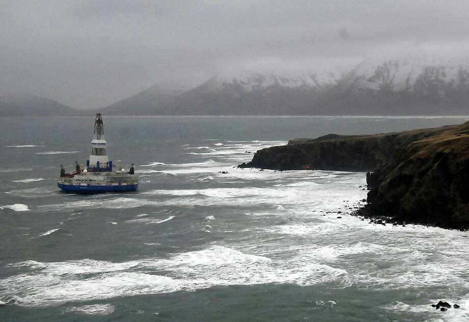
Shell's Kulluk rig ran aground off an Alaskan island in December 2012, illustrating the difficulty
(Photo: Travis Marsh, Associated Press)
Industry groups
acknowledge that offshore projects come with long lead times, but they
say deepwater oil will be critical for meeting the country's future
energy needs.
To be sure, any drilling in the affected waters already faced significant challenges in the coming years.
Energy companies have
pulled out of Alaska's Arctic waters, where conditions can be perilous
and weather conditions allow drillers to operate for only a few months
of the year.
In light of more than two years of weak oil prices,
drillers could not justify the costs and risks of exploration there.
Last month, the Bureau of Ocean Energy
Management did not include any blocks in the Atlantic, Arctic or Pacific
in the latest five-year plan to lease offshore land controlled by the
government. Trump could scrap that plan and develop a new auction
schedule for the 2017 to 2022 period, but it typically takes two to
three years to put together a new program.
Drilling in the
Atlantic has also faced challenges from a number of other sources,
including coastal states that could be affected by a spill, as well as
the Pentagon, which said drilling in the Atlantic could disrupt naval
exercises.
The federal
government spent $1.5 billion to compensate drillers whose offshore
leases were canceled due to local and state opposition in North
Carolina, Florida, California and Alaska, according to a 2012
Congressional Budget Office review.
Fifty-nine percent of
voters surveyed in September said they would support blocking leasing
in the Arctic and Atlantic, according to a study from Hart Research
Associates that was paid for by the NRDC and the League of Conservation
Voters.
The survey polled 1,103 registered voters by phone and had a
margin of error plus or minus 2.9 percentage points.
In response, the
pro-drilling Arctic Energy Center conducted a survey of 511 Alaskans
that found 76 percent supported drilling in Arctic waters.
The margin of
error was plus or minus 4.4 percentage points. Alaskans receive a cash
disbursement from the state every year that is underwritten by oil
revenues.
In his statement, Obama
said significant production in the Arctic will not occur in the current
low oil price environment, citing the Department of the Interior
analysis.
He said Arctic communities must focus on economic
diversification.
Though it may be easy to overlook from life on land, the
waters of San Francisco Bay are alive with activity at all hours of the
day.
To visualize how boats navigate the Bay, this is an animated map that takes you on a guided tour through 24 hours of marine telemetry data captured by the US Coast Guard.
Seeing the data in motion lets you discover interesting patterns that
you might miss in a static map, such as this group of fishing boats
leaving Half Moon Bay around the same time in the morning:
or the number of smaller boats that zip by a big ship as it turns around 180 degrees in the Oakland turning basin:
or the general traffic patterns in the central bay :
Deep sea explorers have discovered a
treasure trove of new species who've make themselves at home on the
Lonqui vents in the Indian Ocean.
There is still so much we do not know about the planet we live on, let alone the universe we inhabit.
Longqi vent field localization with the GeoGarage platform (UKHO chart)
Unique New Species
An
undersea expedition in November 2011 to study deep sea hydrothermal
vents revealed previously unrecorded species of unique marine life.
The
team behind the discoveries is composed of scientists from the
University of Southampton, together with colleagues from the Natural
History Museum in London and Newcastle University.
The results of their
study is published in the journal Scientific Reports.
"Jabberwocky," a black smoker vent in the Longqi vent field on the Southwest Indian Ridge. Credit: University of Southampton
The
hydrothermal vents, undersea hot springs about 2.8 km (1.7 miles) deep,
are located in an area called Longqi (Dragon’s Breath).
It’s an
undersea region spanning an area the size of a football stadium located
in the southwest Indian Ocean and about 2,000 km (1243 miles) southeast
of Madagascar.
These Longqi vents are the first of their kind known in
the region.
The team found more than a dozen mineral spires or
“vent chimneys.”
Rising about 2 stories high from the seabed, these
vents sustained a veritable ecosystem of living creatures surviving from
the hot fluids gushing out of these rocks — and are rich in copper and
gold.
The team analyzed the vents using a deep-diving remotely operated
vehicle (ROV).
Deep Sea Exploration
The research team, led by Jon Copley,
was the first to actually study the Longqi vents and the marine life
attached to them.
A group of hairy-chested ‘Hoff crabs’.
Credit University of Southampton
After genetic comparisons with other species in
different locations were done, the team identified six new species
known only to Longqi: a hairy-chested species of ‘Hoff’ crab, two snail
species, a species of limpet, a scaleworm species, and another species
of deep-sea worm.
The stalked barnacle Neolepas sp. collected from Longqi.
credit David Shale
Most of these are yet to be formally described, except
for one snail species, given the scientific name Gigantopelta aegis.
“We
can be certain that the new species we’ve found also live elsewhere in
the southwest Indian Ocean, as they will have migrated here from other
sites, but at the moment no-one really knows where, or how
well-connected their populations are with those at Longqi,” Copley explained.
“Our results highlight the need to explore other hydrothermal vents in
the southwest Indian Ocean and investigate the connectivity of their
populations, before any impacts from mineral exploration activities and
future deep-sea mining can be assessed.”
These discoveries show us
that space isn’t the only frontier that still needs exploring.
We have
much to learn about our planet’s own mysterious space, the oceans that
comprise about 96.5% of the Earth’s waters.
In West Oz – Lucky Bay, more precisely, 60 clicks from Esperance – a filmer named Ash Gibb went diving to acquire footage for a shark conservation documentary he's planning to make. It was during this dive – the first time shooting for the doco – that he was aggressively rammed in the back, before turning to see a great white shark circling him. Let's hand over to Ash: "I dove down. I was in about five metres of water getting a great shot of this fish and I felt this massive thump from behind. Very quickly I saw the great white shoot into the picture. "At first I was quite excited. I thought, great, this is what I came for. The biggest thing for me was just focusing on my breathing. I didn't want to show that I was scared. I reminded myself of my belief about sharks, which is the fact that they don't eat humans on purpose. We're not their food. "I think that's sort of what got me through a lot of nerves, because it was very intense. Even though I wanted to go and do that, it was a very testing situation. "I went there to show people that they are beautiful creatures, so there was no chance of me fleeing that situation. "I was there to film. I got the opportunity. The chances of that actually happening are one in a million, so I took that opportunity and did my best to keep my hand steady, and capture it on film. "I want to continue on filming. I'd love to see another great white. The bigger the better. "I have over 300 skydives and the Adrenalin does not compare.” (courtesy of Stabmag)
On a recent great white shark cage diving trip we experienced a very rare event, a shark breaching the side of the cage.
What might appear to be an aggressive great white shark trying to attack the cage, this is not the case.
These awesome sharks are biting at large chunks of tuna tied to a rope.
When a great white shark lunges and bites something, it is temporarily blinded.
They also cannot swim backwards.
So this shark lunged at the bait, accidentally hit the side of the cage, was most likely confused and not able to swim backwards, it thrust forward and broke the metal rail of the cage.
There was a single diver inside the cage.
He ended up outside the bottom of the cage, looking down on two great white sharks.
The diver is a very experienced dive instructor, remained calm, and when the shark thrashed back outside the cage, the diver calmly swam back up and climbed out completely uninjured.
The boat crew did an outstanding job, lifting the top of the cage, analyzing the frenzied situation, and the shark was out after a few long seconds.
Everyone on the boat returned to the cages the next day, realizing this was a very rare event.
The boat owner, captain, and crew are to be commended for making what could've been a tragic event into a happy ending.
I'm sure God and luck had a bit to do with it too!
New footage captures huge great white shark in Mexico
The massive predator, nicknamed Deep Blue, was spotted in the waters near Mexico's Guadalupe Island. The shark, who is estimated to be around 50 years old, is believed to be one of the largest great white sharks ever seen. She was featured last year in a Discovery network documentary after local researcher Mauricio Hoyos Padilla managed to tag her. (see Discovery article) But Hoyos has posted new footage of Deep Blue that shows her come nail-bitingly close to a cage diver. Hoyos posted the video on Facebookon Monday, August 10, 2015, under the title, “I give you the biggest
white shark ever seen in front of the cages in Guadalupe Island… DEEP
BLUE!!!” The unbelievable footage shows the mammoth shark
swimming around the cage, seemingly ignoring the divers in a roof-less
steel cage. One brave diver decides to swim out of the cage and reaches out to touch the shark. Divers
from across the world travel to Guadalupe, which is located 165 miles
west of Baja California, to see its famous great whites.