Part of the fear of heights is that mad desire to jump from them.
Alenka Artnik is a Slovenian world record holding freediver, and the deepest female with a monofin: she has dived on breath-hold to 122 meters.
Only a few days after that historic dive, we filmed this exploration of the strange desire to jump whenever we find ourselves at a great height.
Turns out we'd both had dreams where we did just that, and we both experienced that in water, you can give into it.
This was filmed at Deans' Blue Hole in the Bahamas, which is 200 meters deep, enough to give anyone vertigo.
Florian Burghardt kept us safe and helped with all kinds of things behind the scenes.
The music is 'Revelations' by Tristan Barton.
Find out more about Alenka's incredible story from the rise of the depths here
From BBC by By Isabelle Gerretsen Could our understanding of the deep ocean help unlock the mysteries of outer space? Nasa's space mission is leading us to unexplored depths of our own planet.
Nasa is on a mission to change that. The US space agency is exploring the deep ocean to search for clues of what oceans on other planets could look like, and push the limits of science and technology in one of the most extreme environments on our planet. It is a mission filled with wonder, danger and a not-insignificant risk of implosion.
The hope is that the underwater discoveries they make will help to unlock some of the mysteries in outer space while also test some of the equipment and experiments needed for missions elsewhere in the Solar System.
Earth's ocean depths are surprisingly similar to some of the conditions Nasa expects to find on other worlds in our Solar System. They could even provide clues about where scientists should be searching for alien life.
The deepest parts of Earth's oceans are known as the hadal zone. Named after Hades, the Greek god of the underworld, it is a forbidding place worthy of its name. Consisting of deep trenches and troughs, it extends 11km (6.8 miles) below the surface of the world's oceans. Cumulatively they account for an area of seabed equivalent to the size of Australia. Yet few vehicles can survive plunging into this dark abyss.
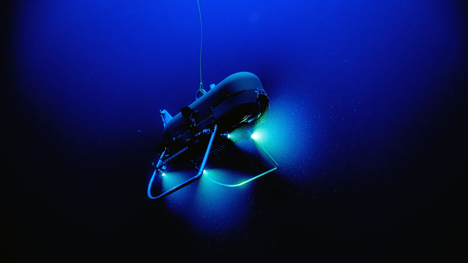
It is here that Nasa scientists, in partnership with the Woods Hole Oceanographic Institute (WHOI) in Massachusetts, are attempting to explore and probe the limits of life on Earth. Even the language the scientists use for their missions to this region shares terms with space exploration – in recent years marine biologists have sent multiple "landers" equipped with sensors and cameras to "crash-land" on the floor of the hadal zone, where they take measurements.
Once thought to be devoid of life, hydrothermal vents in the deep ocean have been found to teem with creatures (Credit: Science Photo Library)
But
engineers from Nasa's Jet Propulsion Laboratory in Southern California
are building a new autonomous underwater vehicle called Orpheus, after
the ancient Greek hero who travelled to the underworld and back, to map
the more inaccessible depths.
Using similar visual navigation technology
to Nasa's Perseverance Mars Rover,
Orpheus uses highly sensitive cameras to identify rock formations,
shells and other features on the ocean floor to build up
three-dimensional maps dotted with landmarks (or perhaps seabedmarks).
This allows the robot to find its way and recognise places it has
already been, but should also help it shed new light on the biodiversity
of this harsh environment.
"After 12 hours, we saw it coming up in small pieces," says Shank,
adding that the loss of Nereus made them rethink how they explore the
deep sea.
About the size of a quad bike and weighing around 550 pounds
(250kg), Orpheus is designed to be much lighter, smaller and cheaper
than previous underwater vehicles.
This should make it nimbler too,
allowing it to get into trenches and vents in the sea floor that have
never been explored before.
Europa on Earth
For a long time, marine biologists thought that life in the hadal zone was impossible, but as deep sea submersibles began venturing into the region in the first half of the 20th Century, it became apparent life could survive there.
But it was still believed that all living organisms were sustained by a food chain ultimately fueled by photosynthesis.
Plants, algae and some marine bacteria in surface waters convert the Sun's energy into sugars which they store in their organic matter.
This is then eaten by herbivores, which in turn are eaten by carnivorous animals.
Scientists were convinced that organisms on the ocean floor survived off dead organic matter – the carcasses of animals, faeces and the steady fall of other organic detritus or "marine snow" drifting down from above.
But it was thought there was not enough food to sustain anything much in the way of sea creatures and the deepest areas were believed to still be too dark and cold for life.
These are animals that don't require direct sunlight… they live off chemicals coming out of the sea floor – Tim Shank
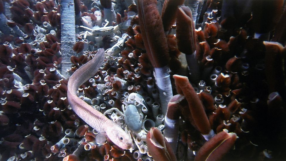
But this perception of the deep ocean changed in 1977, when a US research team dropped a remotely operated vehicle 8,000ft (2,440m) into the Pacific Ocean. The vehicle was dispatched to take images of hydrothermal vents, where heat from volcanic activity seeped from the ocean floor.
To their amazement, the scientists discovered vibrant ecosystems around the vents, teeming with marine organisms, such as translucent snailfish and amphipods, tiny flea-like crustaceans, that had never been seen before.
"With this discovery, we [came across] a whole new way of living on Earth," says Shank. "These are animals that don't require direct sunlight... they live off chemicals coming out of the sea floor."
The scientists were perplexed: how could species in the hadal zone survive such crushing pressure? "The pressure is 15,000 pounds per square inch," says Shank. "It's so intense that the individual cells of an animal would be squeezed out."
Since that first sighting in 1977, scientists have discovered that organisms living at such depths have adapted on a cellular level to survive down there, says Shank. Creatures in the hadal zone, such as giant amphipod crustaceans and the snailfish,have enzymes called piezolytes (from the Greek "piezin" for pressure), which stop their cellular membranes and proteins from being crushed under extremely high pressure. The piezolytes counteract the pressure by increasing the space that proteins take up inside the organism's cells to counteract the weight of the water around it. "It's like putting the stakes up in a tent," says Shank.
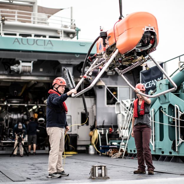
Orpheus is constructed using some of the foam left over from James Cameron's Deepsea Challenger (Credit: Woods Hole Oceanographic Institution)
Discovering organisms that can not only survive, but thrive in such an oppressive environment, raises important questions for biologists looking beyond the realms of our own planet – might it also be found on other ocean worlds.
Below the icy surface of Jupiter's moon Europa lies a salt-water ocean that is thought to be between 40 to 100 miles deep (60-150km) and contains twice as much water as all of Earth's oceans combined. Sunlight doesn't penetrate below Europa's thick ice sheet, which is crisscrossed by cracks and fractures. Beneath the icy crust, the pressure is comparable to the hadal zone.
"Here we have Europa on Earth," says Shank. "I don't see how we could do exploration on Europa, until we did it on Earth."
A robot capable of exploring the Earth's hadal zone could do the same on a frozen moon 628.3 million km (390.4 million miles) away.
"The ocean floor is a great testbed for us to develop the technology that we need in order to have a successful mission to one of these ocean worlds," says Russell Smith, an engineer from Nasa's Jet Propulsion Laboratory, who is part of the team building Orpheus.
A robot operating in outer space or the deep ocean, however, must be completely autonomous. "The robot has to be able to make decisions," says Smith, noting that the aim is for Orpheus to be able to detect and classify environmental DNA and chemicals in the water, as well as bring back samples from the ocean floor.
Building a robot for the hadal zone is incredibly challenging, he says.
"Developing a vehicle that is going to survive is really hard," says Smith. "You need really thick walls to prevent the electronics from getting crushed or wet." Orpheus is partly constructed from syntactic foam, a buoyant material composed of microscopic glass spheres set in epoxy resin. The foam used in Orpheus comes from leftover material produced for film director James Cameron's Deepsea Challenger, which descended to the bottom of the Mariana Trench, in the western Pacific, in 2012.
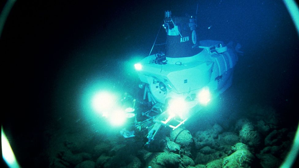
Alvin was the first remotely operated vehicle to visit hydrothermal events when it dived to the deep sea floor in 1977 (Credit: Ralph White/Getty Images)
As it is pitch black in the deep ocean, Orpheus is equipped with a huge flashlight. If the light stays on the entire time, it will quickly drain the robot's battery, leaving it stranded at the crushing depths. To conserve power, Orpheus will switch to a low-power mode when it isn't taking images or samples, says Smith.
Mission to the Moon
In 2017, Nasa launched the Systematic Underwater Biogeochemical Science and Exploration Analog, also known as Subsea, to bring together the fields of space and ocean exploration. To date, they have carried out two missions with remotely operated vehicles to hydrothermal vents in the Pacific Ocean.
In 2023, Nasa will send a robotic rover to look for water-ice at our Moon's south pole
"The whole project was predicated on finding areas in our deep ocean that had a really good analogous nature to what is predicted to be active in places like Enceladus," says Darlene Lim, a Nasa geobiologist who is leading the Subsea programme and preparing astronauts for exploration of the Moon and deep space.
Scientists used the two Subsea missions to gain a better understanding of the geology and chemistry of these vents and the life found around them.
"These vents are very innocuous," says Lim. "You have to look very closely for a temperature change in the water coming up through the ground and interacting with very cold seawater. Even that act alone is very valuable for how we might anticipate having to do exploration on some of these ocean worlds in our solar system."
While sending robots to Europa and Enceladus may still be decades away, Nasa scientists are already applying what they have learned from deep ocean exploration to space missions.
In 2023, Nasa will send a robotic rover to look for water-ice at our Moon's south pole. The mission known as the Volatiles Investigating Polar Exploration Rover, or Viper, will study ice near the lunar crater Nobile in the hope it could be mined as a resource for rocket fuel or drinking water. While not operating underwater, a rover roaming around on the Moon will face many of the same technical challenges.
"We're taking all the learnings from Subsea and applying it to Viper," says Lim, who is also the deputy lead project scientist on Viper.
The aim of the Subsea programme was to ensure that scientists met their research goals in extremely challenging conditions, both from a communications and technology perspective.
From an operations perspective, ocean and space exploration also have a lot in common. In both fields, robots are sent to explore treacherous environments which humans cannot reach, supported by remote teams of scientists. But it could also help prepare astronauts for controlling robotic equipment from a lunar base in the future too.
Fewer than 10 scientists went out to sea with the Subsea mission and they worked with a larger group of colleagues on shore. For the Viper mission, a team will operate the rover on Earth in near real-time and will have to analyse data and make decisions very rapidly.
Efficient communication is critical during these missions, says Zara Mirmalek, a social scientist with Nasa who helps scientists prepare for exploration in extreme environments, and has worked on both the Subsea and Viper programmes.
Plumes of water vapour burst from the icy surface of Saturn's sixth largest moon Enceladus – signs of the liquid ocean lurk below (Credit: Nasa/JPL/Space Science Institute)
For deep sea exploration, scientists have to change decisions all the time, depending on the ocean conditions, weather and salinity. "You know that you are going to have less time than you planned for," says Mirmalek. "It's a lot harder to work in the deep ocean because the conditions are so challenging to the technology."
On space missions, communication is extremely limited, says Mirmalek. To prepare for outer space conditions, Mirmalek restricted the Subsea scientists to communicating with each other just once a day. "There were no failures – they met all their research goals," she says.
"Everything we learned by working together with the oceanographic community has been completely invaluable, really priceless, in helping us have confidence in the process that we're using to design our science operations for Viper," says Lim.
But much like missions off our planet, those to the bottom of the oceans are also allowing humanity to look at the Earth in new ways. While Nasa says its oceanographic explorations have yielded "thousands" of scientific discoveries, they are also providing information that could be vital if we hope to continue living on a world with healthy oceans. We need to understand our oceanic environments if we are to save them, says Laura Lorenzoni, ocean biology and biogeochemistry program scientist with the science mission directorate at Nasa.
"This is critical for life on Earth, and the sustained measurements Nasa has done, and continues to do, are fundamental for ensuring a sustainable use of our ocean resources," she says.
It means that each step towards the exploration of other worlds, we learn a little bit more about some of the most unexplored parts of our own blue planet too.
Undersea data cables are critical to the internet upon which the modern world has come to depend. This hidden network forms the backbone of global communications but is surprisingly vulnerable to interference by hostile actors. Protecting this infrastructure may become an increasingly important remit for the Royal Navy.
Background
The first undersea cables were telegraph cables laid by Britain to maintain communication across its empire in the second half of the 19th Century. Telegraph cables were gradually replaced by telephone cables and in the 1980s fibre optic technology revolutionised the volume of data that could be carried by a single cable. As the internet revolution began, this fibre optic cable network expanded and new cables continue to be laid across the globe. At least 97% of all internet and voice data now passes through this network.
A data cable is typically about the same circumference as a garden hose for most of its length, although sections closer to shore have thicker sheathing, are buried in trenches cut below the seabed or even have mating laid over them for protection. Specialist cable laying ships are employed and keep to carefully planned and surveyed routes, avoiding natural obstacles such as reefs, wrecks, sharp drops and inclines and areas of known seismic activity. Besides intentional damage, cables have been accidentally cut by ship’s anchors, fishing activities and have even been attacked by sharks. Laying submarine cables is expensive and time-consuming, demanding the investment of hundreds of millions of dollars before a return is made. To date, more than 1.2 million km of submarine cables have been laid in the oceans of the world, the longest single cable is the Asia-America Gateway (AAG) cable system which runs for over 20,000 km. A typical modern subsea cable is made up of up to 200 fibres, each able to transmit 400Gb of data per second in both directions.
Interference with submarine cables for strategic ends began in earnest during the First World War when Britain cut Germany’s undersea telegraph cables in the English Channel. The single remaining German cable was tapped by Britain allowing it to read messages. In response, the Germans attempted to destroy allied cables and signal stations in the Pacific and Indian Ocean with limited success. Most of this sabotage did not require sophisticated equipment and was usually done in relatively shallow waters by surface vessel using grappling hooks. However German U-boat, U-151 was fitted with a cutting device and in 1918 managed to sever links between New York and Nova Scotia and New York and Panama. The practice of cable cutting continued in all theatres during the Second World War.
The Cold War inspired a new level of submarine cable interference. The most well-known example is operation ‘Ivy Bells’. The US Navy used SSNs adapted with diver lockout chambers to lay cable tapping devices on Soviet cables that linked the Russian naval base at Petropavlovsk to its mainland headquarters in Vladivostok. The devices recorded conversations on magnetic tapes that were recovered and replaced by regular submarine operations. Between 1971-81, when the tap was revealed to the Russians by a US mole, the recordings provided valuable intelligence and insight into Soviet naval planning. This may have been the tip of the iceberg as the USN likely conducted other tapping operations.
In the modern era, Edward Snowden (Heroic privacy rights campaigner/Putin’s useful idiot) revealed to the media that the American NSA and British GCHQ are able to harvest vast amounts of internet data from taps placed both legally or covertly on fibre optic cables all over the world.
A schematic map showing the undersea cable network connecting the US to Europe. The entire global network can be appreciated at the excellent resource: submarinecablemap.com
Most of the explosion in wealth derived from globalisation relies on high-speed communications, quite small disruptions to connectivity can have consequences disproportionate to an apparently minor event. Even very undeveloped nations can be impacted. Off the coast of Somalia in 2017 a single cable was accidentally cut by a ship’s anchor. The outage lasted 3 weeks and cost the country $10 million each day. Some nations are reliant on just one or two cables while some routes have multiple cables. There are at least 19 TransAtlantic cables that connect Europe to the US, offering a measure of redundancy if one or two cables are cut but traffic levels continue to climb.
Deliberate interference with cables does not necessarily require particularly sophisticated technology because they are clearly marked on charts for mariners and inevitably have to traverse shallow waters. There have been instances where cables have been cut by amateur divers and vandals breaking into terminals on land. Just like shipping routes, the constraints of geography have created many ‘chokepoints’ where cables are forced to pass through narrow straits where they are easier to locate and interrupt.
The cable network is owned and managed by a wide variety of international commercial entities (Google, Facebook and Microsoft are now in the cable-laying business). There is some global management of key software elements of the internet such as that exercised by ICANN, an organisation that manages domain name allocation, but there is no international or even much government oversight of the physical infrastructure. Despite being strategic national assets we are reliant on commercial interest to maintain and repair cables.
When cables fail, initially locating the break is the hardest part. Once found, either an ROV is despatched by the cable layer or grapnel hooks are used to retrieve the ends and bring them to the surface where they must be spliced together by hand. The whole process may take anything from a few days to a few weeks and may depend on weather conditions and the depth of the water. In an open conflict, slow or stationary cable laying vessels following predictable routes to attempt repairs would be very easy targets. Cut off
The internet was originally conceived by the US Defense Advanced Research Projects Agency (DARPA) in the 1960s as a military communications network that could survive nuclear strikes. If part of the network was destroyed, signals would automatically be re-routed via other parts of the system. Although the underlying structure of the internet still works this way, there is very limited spare bandwidth to cope, especially if multiple cables are severed. The sheer volume of data could not always be re-routed and would likely slow down or cripple activity across large parts of the web. Some communication by satellite would be possible but is vastly more expensive and the available bandwidth is relatively small. Using every communications satellite available in the Earth’s orbit could carry just 7% of the communications currently sent via cable from the United States alone.
While ‘local parts’ of the internet might continue to be accessible if international cables were cut, many critical services rely on data centres that are overseas, particularly the big tech companies based in the US that dominate the web. The seamless and distributed nature of the internet is both its strength and vulnerability. A company’s data may be housed in a data centre located just down the road but the application that processes it may be running on a server on another continent.
In many people’s minds, the internet is associated with entertainment and social media and the possibility of the web going dark for a few weeks might seem like just a potential inconvenience. Behind the scenes, the internet does far more than deliver Netflix or allow pictures of cats to be uploaded to Facebook. Financial transactions worth over $10 trillion each day are done online and any disruption would have an immediate effect on the economy, potentially crippling the banking system and halting commerce.
Not only are consumers increasingly shopping online, but most companies are now entirely reliant on the web to store and access vast amounts of data, handle administration, distribution, intellectual property, send and receive payments and much more. Few organisations have parallel offline processes in place that could quickly be activated to replace online systems and life in most western societies would be turned upside down without the internet. One of the legacies of the pandemic is going to be an even greater reliance upon online connectivity. Many organisations are considering abandoning or downsizing their offices as employees demand to work remotely at least part-time or with only occasional in-person meetings. Wake up call
In 2017 the think tank, Policy Exchange published a landmark document written by Rishi Sunak outlining the threat to undersea cables in a UK context. We will not repeat the full content of this excellent work but the piece names Russia as the primary actor developing the capabilities and having the potential motivation to interfere with submarine cables.
Sunak has subsequently experienced a meteoric political rise and now wields enormous influence as Chancellor of the Exchequer. If not the instigator himself, he would certainly have been in favour of investing in “Multi-Role Research Vessels” announced by the Prime Minister in November. In his Christmas address to the fleet, First Sea Lord mentioned the vessels, labelling them slightly differently as “two new ocean surveillance ships”. He said their purpose would be “to help with data gathering but also help us protect critical national infrastructure and undersea cables.”
The Belgorod (Project 09852) is an adapted Oscar class SSGN special-purpose boat designed to be ‘mother’ to the Losharik deep-diving midget submarine. It can also carry other mini-submarines and transport portable nuclear reactors (on the rear casing) to provide power for underwater sensor arrays. The forward section of Belgorod has also been adapted to launch giant KANYON long-range nuclear powered and armed torpedos (This and main article image via: Bill Wright.)
The Russian threat
Cutting submarine cables is a deniable activity that would suit a power like Russia that my try to achieve its ends operating in the ‘grey zone’ below the threshold for full-scale war. This kind of asymmetric attack is attractive for a ‘weaker power’, the activity is low risk and for a relatively modest investment and could potentially achieve enormous impact. Russia is dependent on the internet but the Western economies would be much more exposed to loss of connectivity. The UK has been particularly successful in developing its digital economy, even amongst other developed nations and would be especially harmed by a loss of internet access.
Russia is investing in sophisticated naval assets that could be employed to cut specific cables in a targeted and covert way. Submersible with arms that can manipulate objects on the sea bed can place taps, cut cables or leave devices that could cut cables upon command in the future. The research ship Yantar is officially classed as Auxiliary General Oceanographic Research (AGOR), with underwater rescue capability. She is tasked by the shadowy GUGI (Main Directorate Deep-Sea Research) which is an arm of the Russian Defence Ministry but separate from the Navy. Yantar has been seen operating close to seabed cables on several occasions by open-source intelligence analysts and is doubtless tracked much more closely by professional naval intelligence. There is no evidence of nefarious activities yet but Yantar has likely been primarily engaged in information gathering, charting the location and vulnerabilities of cables and other undersea energy infrastructure should they wish to interfere with them in the future.
The US maintains a secretive underwater network of sensors (Formerly SOSUS, now known as the Integrated Undersea Surveillance System (IUSS)) used to track submarine activity. IUSS is increasingly mobile and less reliant on fixed infrastructure but it does still exist and adversaries remain interested in the location of the sensor arrays and supporting cables. As part of its attempts to dominate the Arctic, Russia is known to be laying its own network of arrays under the ice called HARMONY. Incredibly, the system is believed to be powered by a series of small submarine-portable nuclear reactors laid on the seabed.
The construction of such a complicated system is only possible because GUGI operates the largest fleet of covert manned submersibles in the world. This fleet includes six nuclear-powered mini-submarines; 2 x Paltus (730 tons) 3, x Kashalot (1,580 tons) and Losharik (2,100 tons). Supporting them are two large ‘mother’ submarines that can covertly convey their deep-diving babies over long ranges. Although the construction of HARMONY may be the initial task, this transporter submarine capability means the Russians can potentially interfere with submarine cables unseen anywhere in the world’s oceans.
USNS Zeus comes alongside in Portsmouth, October 2015. In service since 1984, this is the US Navy’s only active cable layer and repair ship. Her primary mission is most likely the construction and maintenance of cables linking the IUSS network. In March 2021, the US division of BMT was awarded the contract to conduct industry studies for the replacement programme to build a new ship with an option for a second vessel. (Photo: Brian O’Rourke)
Securing the lines
Protecting cables that stretch for thousands of miles across the deep ocean floor is extremely challenging and potentially expensive but there are three main ways in which security could be improved.
Legal and regulatory. There is limited protection for submarine cables in international law and this could be addressed with a new International treaty with punitive sanctions against any nation proven to have interfered with cables. This would at least help raise the threshold of risk for actors contemplating such action. Cable Protection Zones could also be implemented in areas of shallower waters where vital cables at risk. Areas covered by these regulations would not allow, surface ships conducting ‘research activity’, fishing, ships anchoring or diving. Even assuming all nations would be willing to accept a new treaty, like all regulation of the marine environment, the primary difficulty is to ensure round the clock enforcement.
Capacity and redundancy. Key data traffic routes could be backed up by redundant extra ‘dark’ cables, ideally not marked on charts and buried as much as possible. There is already some redundancy in the system as accidental cable breaks occur frequently but there is limited financial incentive to invest large numbers of new cables, capable of providing the level of resilience required if a concerted attack cut multiple connections. Building this additional resilience would likely require government funding in partnership with cable companies.
Surveillance and deterrence. It is possible that cables could be fitted with sensors that can detect the sonar frequencies used by submersibles intent on interference and alert authorities ashore. It may also be possible to use fibre optic cables themselves as sensors. Small or unusual movements in the cable caused by interference may be detectable by analysing the transmission of light through the cable. There are already research programmes underway to investigate using undersea cables to measure distant seismic activity.
New developments make the deployment of a fleet of UUVs to patrol up and down sections of cable practical and affordable. Persistent Autonomous Underwater Vehicles (PAUV) that use very little power and are can operate independently for several months are maturing and could be a solution. The deployment of patrol UUVs and the inspection and rapid repair of submarine cables could be a task for the new Ocean Surveillance/Research Vessels. This activity cannot be undertaken by the UK alone and would require co-operation with other nations willing to invest significantly in cable security.
The RAF recently stood up a new ‘Space Command’ with its mission to “protect the UK’s interests in space”. Loss of satellite links would severely hamper military command and control systems, communications and ISR in particular, but cutting a few seabed cables has the potential to cause damage measured in hundreds of £Billions and affect every aspect of society. The ability to disrupt satellites is limited to a few powerful nations but the bar to disruption of seabed infrastructure is much lower and more easily achieved. Part of the tasking for the newly established NATO North Atlantic Command (based in Norfolk, Virginia) is to monitor threats against undersea infrastructure – the nearest organisation (or ‘Inner Space Command’) currently in existence to address an arguably greater threat.
Unlike the nuclear or cruise missile threat, specific deterrence against data cable interference cannot be maintained with the option to respond in kind. All that can be done is to make it riskier for adversaries to contemplate by improved regulation and surveillance. In broader terms, further improvements in anti-submarine and underwater warfare capability for the RN and across NATO is needed. Small steps such as the new RVs and the procurement of the Manta XLUUV technology demonstrator are moves in the right direction but there is much more to be done to secure the backbone of global communications.
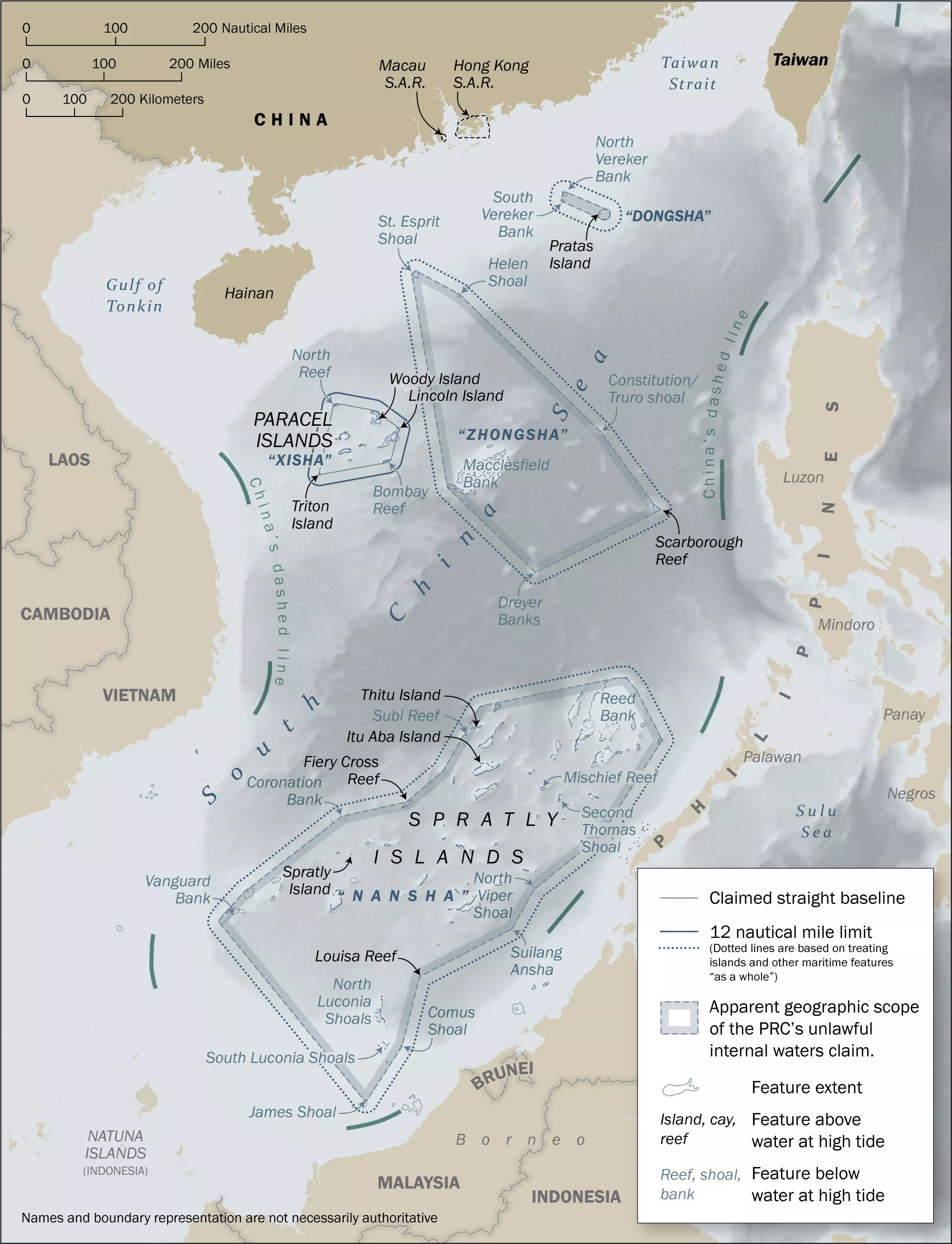
Illustrative
map of the apparent geographic extents of the Dongsha, Xisha, Zhongsha
and Nansha islands, from which China claims its maritime zones. The map was released in a State Department report titled Limits in the Seas No. 150,
on January 12, 2022, which found China’s sweeping claims to most of the
South China Sea inconsistent with international law.
The United States has provided its most comprehensive rejection of China's claims to vast swathes of the South China Sea in a 44-page study published by the State Department on Wednesday.
The People's Republic of China (PRC) asserts what it calls "historic rights" to every island within its "nine-dash line," claiming jurisdiction over waters surrounding hundreds of features in the sea, including those submerged beneath the surface.
The report, Limits in the Seas No. 150, assesses China's maritime rather than territorial claims against provisions of the 1982 United Nations Convention on the Law of the Sea (UNCLOS).
The U.S.takes no position on sovereignty over the approximately 250 islands, reefs, shoals and banks in the sea, but it insists on the right to innocent passage through its busy trade routes, especially in areas where Beijing's maritime control contradicts international law.
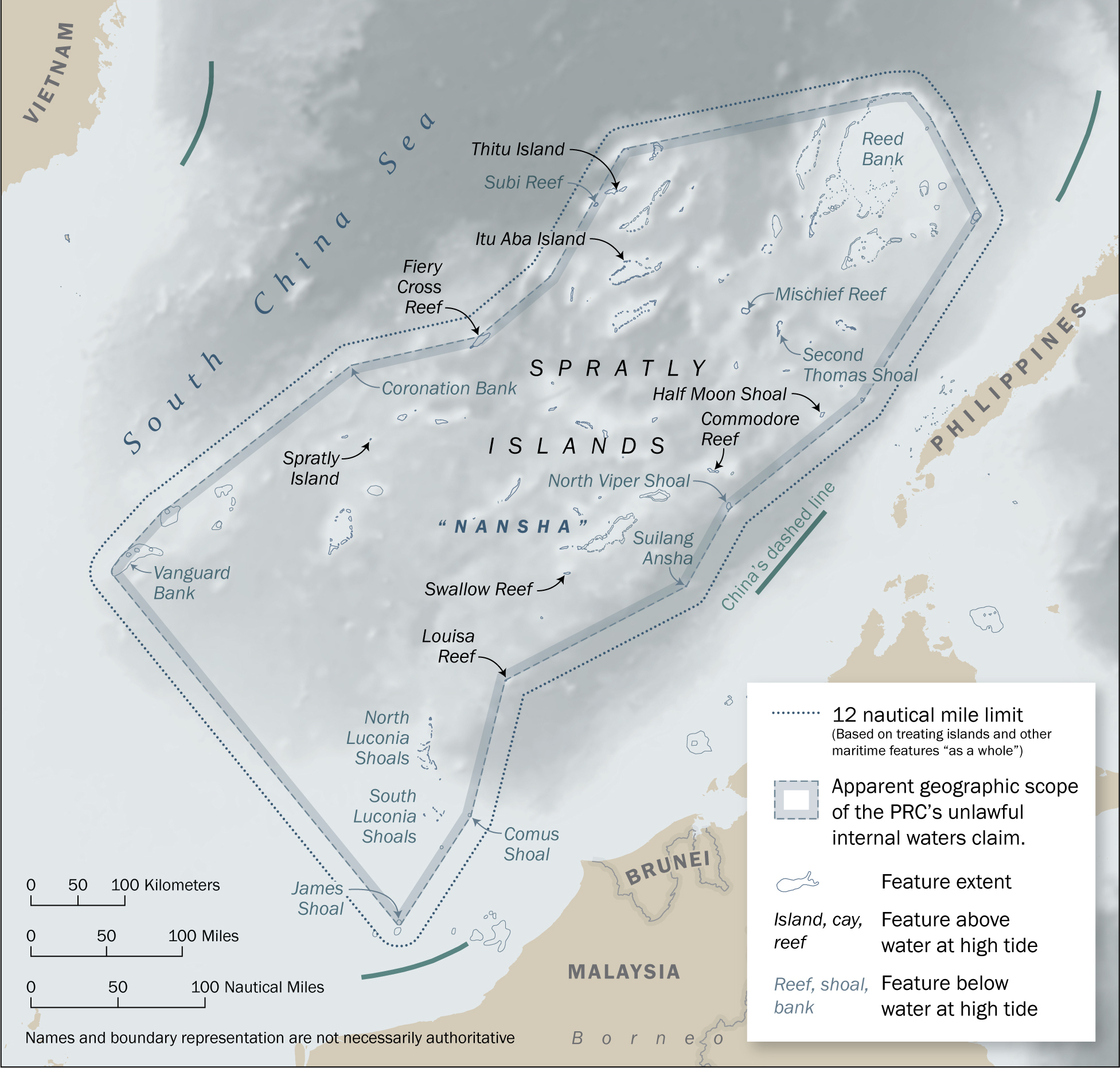
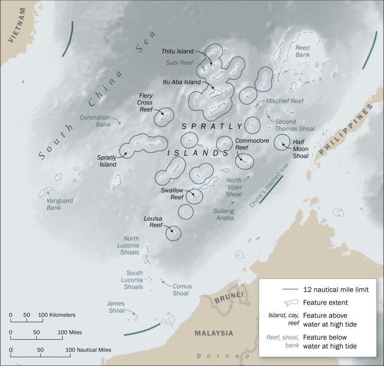
Map of the Nansha (Spratly) Islands, showing the apparent scope of
China’s unlawful internal waters claim and the approximate 12-nautical
mile territorial sea limits from lawful baselines. The map was released in a State Department report titled Limits in the Seas No. 150,
on January 12, 2022, which found China’s sweeping claims to most of the
South China Sea inconsistent with international law.
The study addresses four areas of contention, among them China's claims to more than 100 features in the South China Sea, far beyond its coastal territory, that are submerged at high tide. Under the convention, which China ratified in 1996, such features cannot be lawfully claimed or generate maritime zones.
Beijing not only claims ownership of submerged features, but also joins otherwise geographically disparate areas together to create "straight baselines," drawing large blocks of exclusive waters around archipelagoes in the energy-rich sea. These zones, the report said, appear to exist around four groups: the Pratas (Dongsha), Paracel (Xisha), and Spratly (Nansha) and Zhongsha islands.
Additionally, China, by treating each island group as one unit, asserts claims to internal waters, a territorial sea, an exclusive economic zone and a continental shelf. The practice is inconsistent with UNCLOS, which only allows the drawing of baselines under limited circumstances—an indented coastline or islands in the immediate vicinity of the coast—the authors found.
Lastly, the study determined there was no legal basis for China to assert "historic rights" in the South China Sea. Beijing has never provided a legal rationale for its claim. "No provision of the Convention contains the term 'historic rights,' nor is there a uniform understanding of what, specifically, the term means as a matter of international law," the report said.
"The overall effect of these maritime claims is that the PRC unlawfully claims sovereignty or some form of exclusive jurisdiction over most of the South China Sea.
These claims, especially considering their expansive geographic and substantive scope, gravely undermine the rule of law in the oceans and numerous universally recognized provisions of international law reflected in the Convention," it concluded.
"For this reason, the United States and numerous other States have rejected these claims in favor of the rules-based international maritime order within the South China Sea and worldwide," wrote principal authors Kevin Baumert, Amy Stern and Amanda Williams, who conducted the research for the Office of Ocean and Polar Affairs under the Bureau of Oceans and International Environmental and Scientific Affairs at the State Department.
The study reaffirmed American backing for a 2016 ruling by the Permanent Court of Arbitration in The Hague, which dismissed China's extensive "nine-dash line" claims in the verdict of Philippines v.
China, also known as the South China Sea Arbitration.
An earlier study from 2014, Limits in the Seas No. 143, had also found the "dashed line" inconsistent with UNCLOS.
"With the release of this latest study, the United States calls again on the PRC to conform its maritime claims to international law as reflected in the Law of the Sea Convention, to comply with the decision of the arbitral tribunal in its award of July 12, 2016, in The South China Sea Arbitration, and to cease its unlawful and coercive activities in the South China Sea," the State Department said in an accompanying statement.
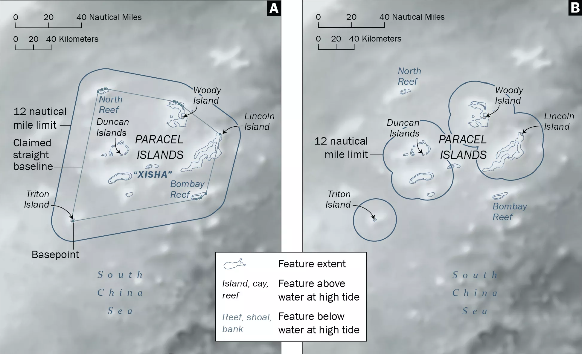
Illustrative maps of the Xisha (Paracel) Islands, (A) showing China’s claimed straight baselines and territorial sea limits and (B) showing the appropriate 12-nautical mile territorial sea limits from lawful baselines. The maps were released in a State Department report titled Limits in the Seas No. 150, on January 12, 2022, which found China’s sweeping claims to most of the South China Sea inconsistent with international law.
DEPARTMENT OF STATE
Illustrative
maps of the Zhongsha Islands, (A) showing the apparent scopre of China's unlawful internal waters and (B)showing the
appropriate 12-nautical mile territorial sea limits from lawful
baselines. The maps were released in a State Department report titled Limits in the Seas No. 150,
on January 12, 2022, which found China’s sweeping claims to most of the
South China Sea inconsistent with international law.
DEPARTMENT OF STATE
The detailed analysis, which is certain to serve as a key reference in further research and public debate on the subject, drew an immediate response from the Chinese government on Thursday, but it repeated positions already addressed in the U.S. study and failed to answer outstanding questions surrounding their legitimacy.
China's Foreign Ministry spokesperson Wang Wenbin said the study "distorts international law, confuses the public, sows discord and disrupts the regional situation."
He said: "China has historic rights in the South China Sea. China's sovereignty and related rights and interests in the South China Sea have been established over a long period of history and are consistent with international law, including the UN Charter and the UN Convention on the Law of the Sea."
He repeated China's rejection in full of the 2016 ruling in The Hague, calling the verdict "illegal, null and void."
A thousand feet below the Antarctic seas’ surface, a breeding colony of icefish, 60 million active nests across 92 square miles observed during a series of deep dives.
Scientists discovered a mammoth nesting ground with an estimated 60 million icefish nests in the Weddell Sea.
As soon as the remotely operated camera glimpsed the bottom of the Weddell Sea, more than a thousand feet below the icy ceiling at the surface, Lilian Boehringer, a student researcher at the Alfred Wegener Institute in Germany, saw the icefish nests.
The sandy craters dimpled the seafloor, each the size of a hula hoop and less than a foot apart.
Each crater held a single, stolid icefish, dark pectoral fins outspread like bat wings over a clutch of eggs.
Aptly named icefishes thrive in waters just above freezing with enormous hearts and blood that runs clear as vodka.
Their blood is transparent because they lack red blood cells and hemoglobin to transport oxygen throughout the body. Icefishes’ loss of hemoglobin genes was less an evolutionary adaptation than a happy accident, one that has allowed them to absorb the oxygen-rich Antarctic waters through their skin.
The sighting occurred in February 2021 in the camera room aboard a research ship, the Polarstern, which had come to the Weddell Sea to study other things, not icefish.
It was 3 a.m. near Antarctica, meaning the sun was out but most of the ship was asleep.
To Ms. Boehringer’s surprise, the camera kept transmitting pictures as it moved with the ship, revealing an uninterrupted horizon of icefish nests every 20 seconds. “It just didn’t stop,” Ms. Boehringer said. “They were everywhere.”
Half an hour later, Autun Purser, a deep-sea biologist at the same institute, joined Ms. Boehringer.
On the camera feed there remained nothing but nests. “We were like, is this ever going to end?” Dr. Purser said.
“How come no one has ever seen this before?”
Some nests were guarded by a single fish, others had eggs but no fish, a fish carcass furred white with bacteria or nothing at all.
Credit...PS118, AWI OFOBS team
The nests persisted for the entire four-hour dive, with a total of 16,160 recorded on camera.
After two more dives by the camera, the scientists estimated the colony of Neopagetopsis ionah icefish stretched across 92 square miles of the serene Antarctic sea, totaling 60 million active nests.
The researchers described the site — the largest fish breeding colony ever discovered — in a paper published Thursday in the journal Current Biology.
“Holy cow,” said C.-H. Christina Cheng, an evolutionary biologist at the University of Illinois-Urbana-Champaign, who was not involved with the research.
“This is really unprecedented,” she said.
“It is crazy dense. It is a major discovery.”
Location of Neopagetopsis ionah breeding colony, local seafloor temperature conditions, and Weddell seal behavior
The paper provides “evidence of a complex and so far undescribed benthic ecosystem in the Weddell Sea,” said Mario La Mesa, a biologist at the Institute of Polar Sciences in Bologna, Italy, who was not involved with the research.
“I would not be surprised to find other massive colonies of breeding fishes elsewhere,” said Dr. La Mesa, who last year described the same Antarctic icefish species’ nest-guarding behavior from sites near the newly discovered colony.
Each of the newly discovered nests held, on average, 1,735 large, yolky eggs — low fecundity for a fish.
An unprotected clutch would prove an easy snack for predators like starfish, polychaete worms and sea spiders, Dr. Cheng said.
So the males stand sentry to ensure their offspring are not devoured, at least not before they have the chance to hatch, and may clean the nests with their elongated lower jaw, according to Manuel Novillo, a researcher at the Bernardino Rivadavia Museum of Natural Science in Argentina, who was not involved with the research.
About three-quarters of the colony’s nests were guarded by a single fish.
The others had eggs but no fish, a fish carcass furred white with bacteria or nothing at all.
Near the edges of the colony, many unused or abandoned nests cradled several icefish carcasses, many with starfishes and octopuses feasting on their eyes and soft parts. “If you die in the fish nest area, you rot there,” Dr. Purser said.
“But if you die at the edges, then it seems to be everyone grabs you and starts eating you there.”
The researchers observed that the colony occupied an unusually warm patch of deep water, with temperatures up to about 35 degrees Fahrenheit — practically toasty compared to other Antarctic waters.
In February 2021, the research icebreaker RV Polarstern discovered the most extensive fish breeding colony discovered to date, at ~500 m depth below the Weddell Sea sea ice.
The colony was found to cover at least 200 square kilometers of seafloor. 12,020 active nests were imaged within 2,145 images.
Seal tracking data seem to indicate that Weddell Seals feed on these fish, diving to the depths of the nests repeatedly.
Although the discovery of the nests contributes to scientists’ understanding of the icefish life cycle, it raises even more questions.
How often are the nests built, and are they reused?
Do the fish die after the eggs hatch?
Or, perhaps the most obvious: “Why there?” Dr. Cheng asked.
The authors have no sure answers, only speculations.
Maybe the warm deep currents guide the fish to the grounds.
Maybe there is a bounty of zooplankton for the fry to devour.
Or maybe it’s something else.
ImageA Weddell seal, which feasts on the icefish nests.Credit...Mia Wege/University of Pretoria
But there must be something special about the location of the active colony.
Around 31 miles west, the researchers found a patch of seafloor similarly littered with nests: all empty.
These nests were abandoned, overtaken by sponges and corals — long-living creatures that take years to grow, Dr. Purser said.
Waters above the icefishes’ expansive settlement also host hungry, foraging Weddell seals.
When the researchers collected satellite tracking data from seals during the expedition and analyzed it with historical data, they found, unsurprisingly, that the seals dive primarily to the icefish nests. “They’re having a nice dinner,” Dr. Purser said.
Before the end of the cruise, the researchers deployed a camera that will photograph the site twice daily for two years, hopefully revealing even more about the life cycle of the icefish. Dr. Novillo said he is looking forward to seeing what the camera captures.
“It might constitute the first field observation of courtship behavior and/or nest preparation,” he wrote in an email.
New insights into how icefish reproduce and contribute to polar food webs could help manage and conserve populations.
The authors argue the new paper provides enough evidence to protect the Weddell Sea under the Convention on the Conservation of Antarctic Marine Living Resources.
“The seafloor is not just barren and boring,” Dr. Purser said.
“Such huge discoveries are still there to be made, even today in the 21st century.”
From CNN by Alex Stambaugh, Laura Smith-Spark, Rhea Mogul, Sophie Jeong and Dakin Andone
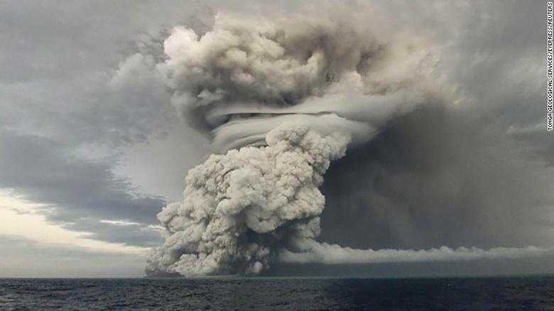
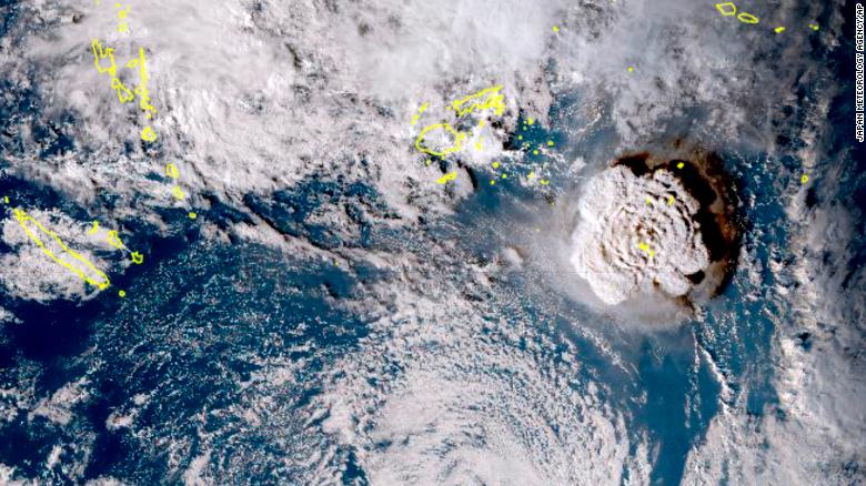
An underwater volcano in the South Pacific erupted violently on Saturday, causing tsunamis to hit Hawaii, Japan, and Tonga's largest island, Tongatapu -- sending waves flooding into the capital.
The Hunga-Tonga-Hunga-Ha'apai volcano, about 30 kilometers (18.6 miles) southeast of Tonga's Fonuafo'ou island, first erupted on Friday and a second time on Saturday around 5:26 p.m. local time, according to CNN affiliate Radio New Zealand (RNZ).
The eruptions sent a plume of ash, gas and steam 20 kilometers (12.4 miles) into the air, according to RNZ. Satellite imagery showed a massive ash cloud and shockwaves spreading from the eruption. Ash was falling from the sky in the Tonga capital, Nuku'alofa, Saturday evening and phone connections were down.
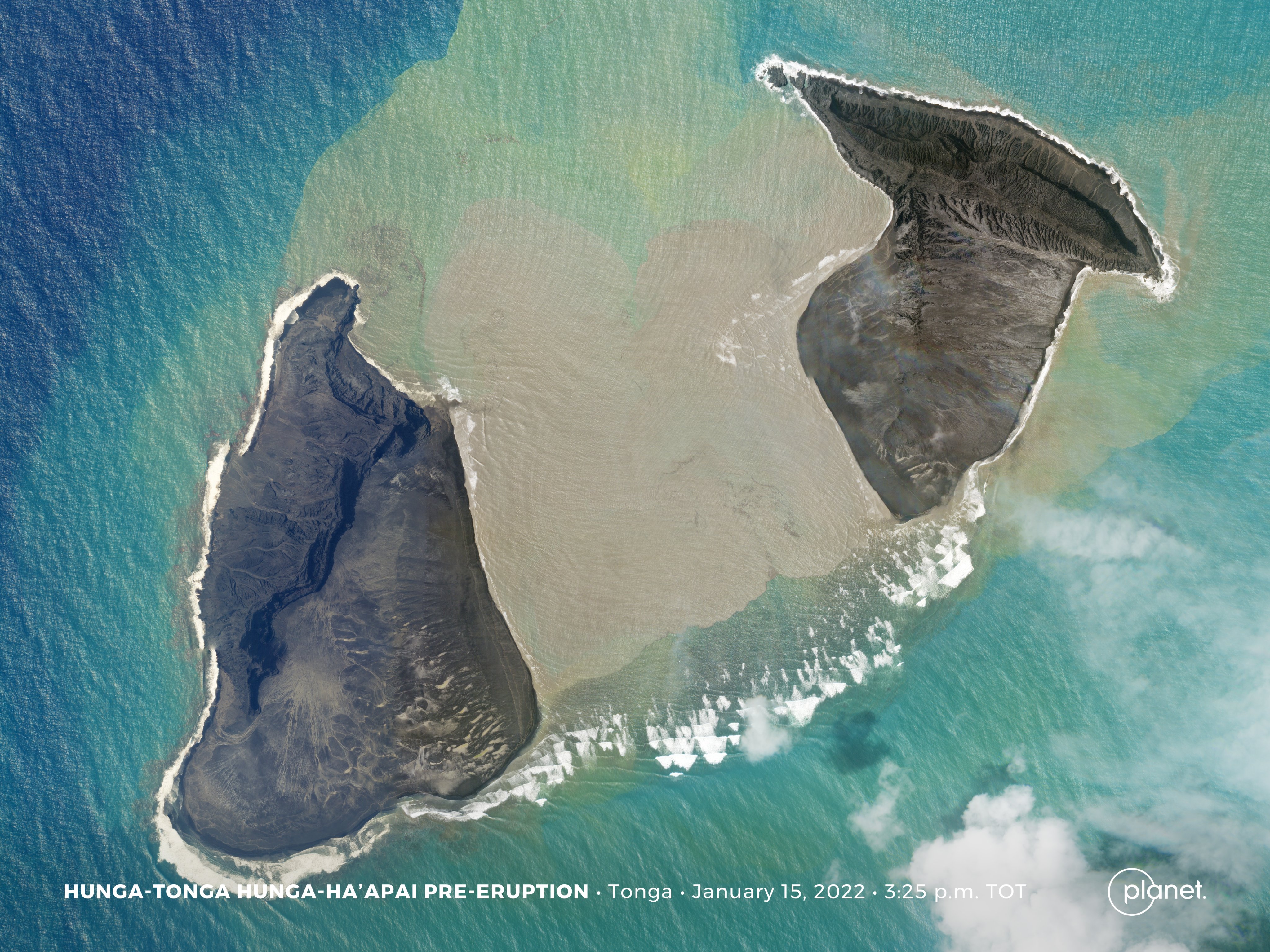
NASA
A Planet SkySat captured an image of Hunga-Tonga Hunga-Ha’apai today at 2:25 UTC, just two hours before its violent eruption that triggered a tsunami.
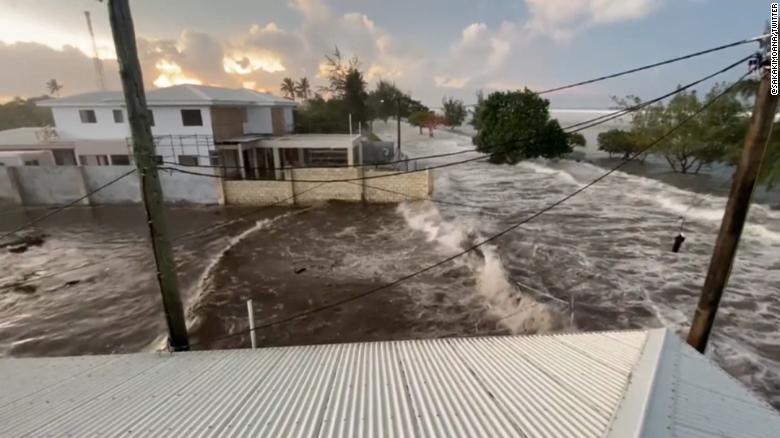
The eruption caused a severe tsunami on Tongatapu, where the capital is located, with waves flowing onto coastal roads and flooding properties on Saturday.
So far, New Zealand authorities have not received any reports of deaths or injuries in Tonga related to the eruption, Prime Minister Jacinda Ardern said at a news conference on Sunday.
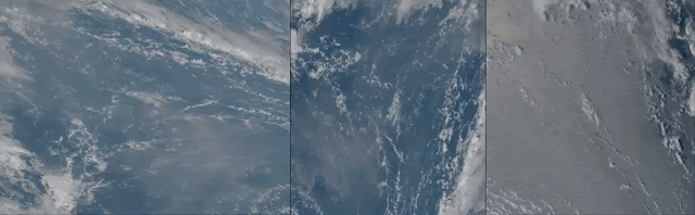
This shows data from all three weather satellites covering the area. From left to right: Korea's GK-2A, Japan's Himawari-8 and the US GOES-17. @simmon-sat
infrered picture
The Tonga-Hunga ha'apai volcano eruption captured by the Fengyun-4B, showing the dispersal of the ash cloud.
The tsunami had a "significant impact" on Nuku'alofa, with boats and large boulders washed ashore, and shops along the coast damaged, she added. RNZ reported that residents fled for higher ground as waves swept the waterfront, main street and grounds of Tonga's Royal Palace.
Though it was early evening, videos show the sky already dark from the ash cloud. Tonga's King Tupou VI was evacuated from the palace, RNZ said, citing local media reports of a convoy of police and troops rushing the monarch to a villa at Mata Ki Eua. Telecommunications were affected, though it's not clear how widespread the damage is yet, Ardern said, adding that the main undersea cable has been impacted likely due to loss of power. The New Zealand government has committed an initial $340,000 in relief supplies, technical support, and supporting local responses, with the country's Defence Force sending assistance to Tonga, Ardern said. She added that while conditions in the area seem stable, further eruption activity cannot be ruled out.
Impact in Japan
The eruption also had effects across the Pacific, as tsunami warnings and advisories were issued from parts of New Zealand and Japan to the United States and Canada's British Columbia. Per the National Weather Service, a tsunami warning means those nearby should get inland or seek higher ground immediately, while an advisory means they should stay away from the shore and out of the water. Japan's Meteorological Agency issued a tsunami advisory for the country's coastal areas early Sunday morning, with the northeastern prefecture of Iwate seeing waves as high as 2.7 meters (9 feet).
Multiple smaller tsunamis were reported in numerous other locations, according to public broadcaster NHK. By Sunday afternoon, all tsunami advisories had been lifted, the meteorological agency said.
Weather agency officials ruled out the possibility of further tsunamis across the country, but said there might be some tidal fluctuations. Japan's coast guard was out assessing damage, but so far none had been reported, NHK said, noting it was still dark and more waves were expected.
Officials continued to ask people to stay alert and away from beaches. Footage shared on NHK from a viewer in Setouchi town, on Amami Oshima Island, showed bumper-to-bumper traffic as cars evacuated to higher ground.
Other footage showed people sleeping on floors in evacuation centers in Iwate.
A tsunami has hit Tonga's largest island, Tongatapu.
Elsewhere, Australia's Bureau of Meteorology said it recorded a tsunami wave of 1.2 meters (about 4 feet) near Nuku'alofa at 5:30 p.m. local time on Saturday.
And the Pacific Tsunami Warning Center said tsunami waves of 2.7 feet (0.8 meters) were observed by gauges at Nuku'alofa and waves of 2 feet at Pago Pago, the capital of American Samoa, Reuters reported. The nearby island of Fiji also issued a public advisory asking people living in low-lying coastal areas to "move to safety in anticipation of the strong currents and dangerous waves."
Footage from the ground shows people fleeing to higher ground in Suva, the capital of Fiji, as large waves hit the coast. In Samoa, another Pacific island nation, a tsunami watch is in effect for all low-lying coastal areas, the Samoa Meteorological Service said, with residents and visitors advised to stay away from beach areas. An earlier tsunami advisory for the Pacific island nation of Vanuatu was discontinued, with the country's National Disaster Management issuing an "all clear."
The office had earlier advised residents to move away from the coastline and seek higher ground.
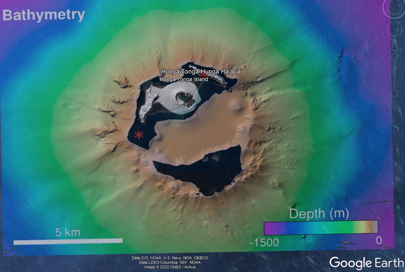
That
map, created with April 2016 data from the R/V Falkor, showed details
of the overall volcanic edifice. Measured on this quick Google Earth
overlay, the diameter of the caldera rim is ~6 km. Recent eruptions have
been on the N and NE sides. Red * is 2009 vent.
I rendered this of #HTHH after we surveyed it with #RVFalkor. Rainbow colors show the shape of the underwater volcano and the browns are the island above water. Black shows data gaps - too shallow to safely navigate. pic.twitter.com/VIvGDs4Wmq
The eruption also sent waves to the US West Coast, with some exceeding 3 and 4 feet in height, according to the National Weather Service office in San Diego. The highest waves recorded were in Port San Luis, California (4.3 feet); King Cove, Alaska (3.3 feet); Area Cove, California (3.7 feet); Crescent City, California (3.7 feet); and Port Reyes, California (2.9 feet). The first tsunami waves were felt on the West Coast early Saturday morning, according to Dave Snider, the tsunami warning coordinator at the National Weather Service's National Tsunami Warning Center in Palmer, Alaska. A wave as high as 1.2 feet had been observed in Nikolski, Alaska, he told CNN via telephone, while waves as tall as 1 foot were observed in Atka, Adak and King Cove, Alaska. "This may not be the largest wave as this is coming in yet," Snider told CNN, saying the event was not over.
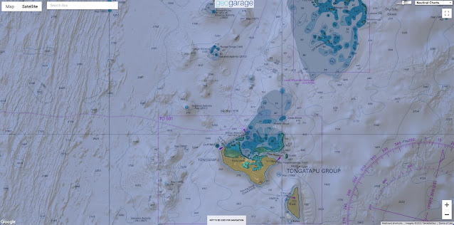
Localization of the vulcano in the North of Tonga with the GeoGarage platform (NZ Linz)
Ash rises into the air after a powerful underwater volcanic eruption in the South Pacific.
The initial coastal tsunami advisory included the states of California, Oregon, Washington and Alaska, according to the National Tsunami Warning Center. All of the advisories had been lifted by early Sunday morning, according the Tsunami Warning Center. The Pacific Tsunami Warning tweeted no damage was reported thus far from the tsunami observed in the Hawaiian Islands.
A tsunami advisory for Hawaii was canceled by the agency Saturday morning. Adam Weintraub, a spokesperson for the Hawaii Emergency Management Agency, told CNN there were "no reports of major damage so far," though the effects had been felt across multiple islands. Officials were still assessing the damage. The impacts were the equivalent of a "high King Tide," Weintraub said earlier, telling CNN there had been flooding in parking lots and harbor areas he characterized as "nuisance flooding." Speaking by telephone, Snider said, "We don't have a really good forecast because this event is based on a volcano rather than an earthquake." Nonetheless, the National Weather Service in Seattle urged caution along the US Pacific Coast on Saturday.
"Move off the beach and out of harbors and marinas in these areas," NWS Seattle tweeted. The city of Laguna Beach, California, closed all beaches, boardwalks, harbors and piers until further notice in response to the tsunami advisory early Saturday morning, telling residents, "please stay out of the water and away from the shore." Santa Cruz, California, also experienced some "minor flooding" at the harbor, city manager Elizabeth Smith told CNN.
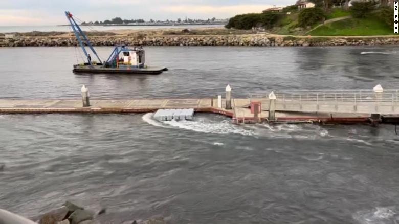
High tide comes into a harbor in Santa Cruz, California, seen in this still image from a video obtained by CNN.
The water quickly drained out, Brad Anderson -- the person that provided the video -- said. The waves came right at high tide, Fire Chief Rob Young said.
The initial wave occurred at approximately 7:40 a.m. local time, he said, bringing with it a 1 to 2-foot wave right at the peak of high tide
The largest wave came in at about 8:49 a.m. local time, prompting a surge of about 7 feet at the harbor. A subsequent surge just after 10 a.m. was "diminished." "When it comes, it comes quickly," he said.
"Not just a 1-foot wave, but it comes in a surge because it draws all the water out first, and then it comes in." There was some damage in the harbor and to some docks, he said.
There was also "light flooding" on the beaches and up to the city's first surface street, Young said. All beaches and the harbor will be closed until at least noon local time, Smith said, and people were evacuated from nearby stores and the area near the harbor, though no one has been evacuated from their homes.
A surf contest has been postponed and is expected to resume later Saturday.
New Zealand on alert
A tsunami advisory was also issued for coastal areas on the north and east coast of New Zealand's North Island and the Chatham Islands, where "strong and unusual currents and unpredictable surges at the shore" were expected, according to New Zealand's National Emergency Management Agency. New Zealand's official weather service said its weather stations across the country had observed "a pressure surge" on Saturday evening from the eruption.
A satellite image taken by Himawari-8, a Japanese weather satellite, and released by the agency, shows an undersea volcano eruption at the Pacific nation of Tonga Saturday, January 15, 2022.
Scientist Emily Lane, of New Zealand's National Institute of Water and Atmospheric Research, told the New Zealand Science Media Centre it was a "very significant" eruption. "The shock wave from it is clearly visible in satellite imagery and there are reports of the eruption being heard at least as far away as New Zealand," she said.
"The tsunami from the eruption has reached over 2,500 kilometers being recorded on gauges over all of Aotearoa." Tsunamis generated by volcanoes are much less common than tsunamis from underwater earthquakes, Lane said. A smaller eruption in late 2014 and early 2015 built up the crater of the volcano to above the surface of the water, Lane added, but it's not yet clear exactly how Hunga-Tonga-Hunga-Ha'apai erupted on this occasion.
"When we see what is left of the island after this eruption is over we can start to put together the pieces of what happened," she said. Professor Shane Cronin, from the School of Environment at the University of Auckland, told the New Zealand Science Media Centre research into historical eruptions by the same volcano suggested the current eruption episode could last for weeks or months "and further similar-sized eruptions to the 15 January 2022 event are possible." "The eruption is likely to result in significant ash fall (up to 10 centimeters) in Tongatapu as well as the Ha'apai group of islands," he said.
"Help will be needed to restore drinking water supplies. People of Tonga must also remain vigilant for further eruptions and especially tsunami with short notice and should avoid low-lying areas." An earlier tsunami warning issued for American Samoa has since been canceled, according to the NWS Pacific Tsunami Warning Center. There is no tsunami threat to Guam and the Commonwealth of the Northern Mariana Islands from a "distant eruption," according to the Pacific Tsunami Warning Center. The volcano had been active from December 20, but was declared dormant on January 11, according to RNZ.
Fred Berho from Hendaye defied the hard conditions of the first storm of 2022 to capture on video the shattering encounter between the ocean and the Artha dike in Saint Jean de Luz (France)


 USNS Zeus comes alongside in Portsmouth, October 2015.