Saturday, May 6, 2023

Old surfer Magoo, still swell at 85

This short piece explores Barry "Magoo" McGuigan’s perception of being involved with surfing since the advent of the sport and the deeply personal ways that surfing has shaped his philosophy to life.. 
The nickname Magoo conjures up images of a well- intentioned but incapable character bumbling through life's daily adventures, even for those too young to have been exposed to the iconic cartoon.
While Barry "Magoo" McGuigan is a lovable spirit, this is where the similarity ends as being Australia's oldest competitive surfer generates extreme focus .
This short piece explores Magoo's perception of being involved with surfing since the advent of the sport and the deeply personal ways that surfing has shaped his philosophy to life.
Unassuming in nature, Magoo is a man of few words but his message is profound and this inspired the film.

Links :

Friday, May 5, 2023

Scientists discover pristine deep-sea Galápagos reef ‘teeming with life’

HOV Alvin’s manipulator arm collects samples from a rocky outcrop on a reef populated by cold-water corals, squat lobsters, anemones, basket stars and deep-sea fish. 
Photograph: U. Bristol/Woods Hole/Oceanographic Institution
 
From The Guardian by Dan Collyns

Diving to 600m, researchers find reefs full of octopus, lobster and fish, raising hopes for corals’ survival amid rising sea temperatures


Scientists operating a submersible have discovered deep-sea coral reefs in pristine condition in a previously unexplored part of the Galápagos marine reserve.


Diving to depths of 600 metres (1,970ft), to the summit of a previously unmapped seamount in the central part of the archipelago, the scientists witnessed a breathtaking mix of deep marine life. 
This has raised hopes that healthy reefs can still thrive at a time when coral is in crisis due to record sea surface temperatures and ocean acidification. 
It also showed the effectiveness of conservation actions and effective management, they said.
 
Galapagos Marine Reserve (2022)
 
Galapagos platform


“They are pristine and teeming with life – pink octopus, batfish, squat lobsters and an array of deep-sea fish, sharks and rays,” said Dr Michelle Taylor, a marine biologist at Essex University and co-leader of the expedition in a human-occupied vehicle, HOV Alvin, a submersible able to take two scientists to depths of 6,500 metres.

 
HOV Alvin being lowered into the Galápagos marine reserve. The submersible can take two scientists to depths of 6,500 metres.
Photograph: Samuel J. Mitchell (U. Bristol)


“This is encouraging news,” said José Antonio Dávalos, the environment minister for Ecuador, which owns the Galápagos. 
“It reaffirms our determination to establish new marine protected areas [MPAs] in Ecuador and to continue promoting the creation of a regional marine protected area in the eastern tropical Pacific.”

The country is collaborating with its northern neighbours Panama, Costa Rica and Colombia on a regional marine corridor initiative, which aims to protect and responsibly manage the ocean.

 
Michelle Taylor looks out from HOV Alvin. Photograph: Darwin Foundation

Operated by Taylor and Dr Stuart Banks, of the Charles Darwin Foundation in Ecuador, HOV Alvin explored unknown regions of the reserve using state-of-the-art sampling capabilities and visual upgrades that included improved high-quality still and ultra-high-definition 4K video-imaging systems.

Prior to this discovery, Wellington Reef, off the coast of Darwin Island in the far north of the Galápagos archipelago, was thought to be among the few structural shallow coral reefs in the islands to have survived the destruction wreaked by an El Niño event in 1982-83.

The find shows that sheltered deep-water coral communities have probably persisted for centuries in the depths of the Galápagos marine reserve, supporting rich, diverse and potentially unique marine communities.

“These newly discovered reefs are potentially of global significance – a ‘canary in the mine’ for other reefs globally – sites which we can monitor over time to see how pristine habitats evolve with our current climate crisis,” Taylor said.

Banks said the reef helped scientists “reconstruct past ocean environments to understand modern climate change”. 
It could also help understand the role of MPAs in the carbon cycle and fisheries. 
“It’s very likely there are more reef structures across different depths waiting to be explored,” he said.

 
A sea urchin on a coral with fossil coral, the foundation of the live reef, in the background.
Photograph: L Robinson, U Bristol/WHOI

A newly established MPA, the Hermandad marine reserve, now connects a chain of seamounts in Ecuadorian waters to offshore marine environments such as Costa Rica’s Cocos Island national park. Scientists say the underwater mountains are migratory routes for marine life and require special measures to protect foraging grounds and sustain responsible fisheries.

Dávalos said the discovery was another reason to achieve the commitments of the Global Ocean Alliance 30x30, which aims to protect at least 30% of the world’s oceans by 2030.

HOV Alvin is owned by the US navy and operated by the Woods Hole Oceanographic Institution (WHOI), as part of the US National Science Foundation-funded National Deep Submergence Facility. It was also financed by the Natural Environmental Research Council in the UK.

Taylor and Banks are also part of an international group of scientists onboard the US navy-owned and WHOI-operated research vessel RV Atlantis, which is undertaking the Galápagos Deep 2023 expedition.

Links :

Thursday, May 4, 2023

The 19th century woman who predicted global warming

Eunice Foote described the greenhouse gas effects of carbon dioxide in 1856.
Carlyn Iverson/NOAA Climate.gov

From Medium by CliveThomson

Eunice Foote made an exceptional scientific discovery in 1856


By now, we all know the problems of greenhouse gases.
Burning fossil fuels creates CO2 — with methane sometimes as side product as well — and it traps the sun’s heat.
The result: Global warming, and all the weirding of climate that comes with it.

We moderns have known this since the 80s, when James Hansen testified to congress.
I was 20 years old and read reports of his testimony with a cold feeling of dread.
I remember thinking, shit: I wish society had known this long ago! We should have taken action years ago!

It turns out that we did know.
Sort of!

The basic idea behind greenhouse gases was discovered over a century earlier — by a female suffragette who, in 1856, did some ingenious scientific experiments.
When she wrote up her work, she neatly and pithily predicted the possibility that we’d one day cook the planet.

Eunice Foote was born in 1819 on a farm in Connecticut, and raised in Bloomfield, New York.
In that period of history, few women received good technical educations, but Foote was an exception: Her parents sent her to the Troy Female Seminary, where she learned advanced math and science.
She later became a prominent supporter of women’s rights; a friend of Elizabeth Cady Stanton, she was on the editorial board of the 1848 Seneca Falls Convention, the first significant suffragist conference.

Foote also was deeply curious about the scientific debates of the day.
Back in the mid 19th century, geologists were uncovering evidence about fascinating shifts of climate in the planet’s past.
By looking at the coal deposits left behind in formerly swampy seas, they figured that Earth’s atmosphere had — for long periods of time — contained considerably higher levels of carbon dioxide.
But, as the Kent State geologist Joseph D.
Ortiz notes
, none of the Victorian-era scientists understood that this increased CO2 would have affected the planet’s temperature.

That’s where Foote came in.
She got intrigued by the question of whether gases can trap heat, and, if so, which gases were most potent at doing this.

So she devised a clever experiment.
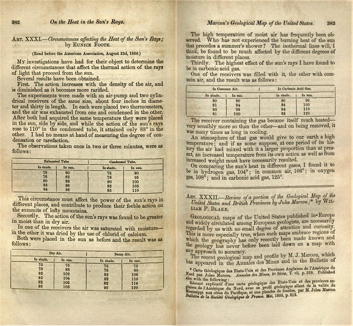
Foote took several glass cylinders and filled them with different combinations of gas: Thin air, thicker air, humid air, and air with “carbonic acid” — what we now refer to as CO2.
She put them in the sun to warm them up, then in the shade to cool them down.
A thermometer inside each jar allowed her to record data on how the gases were affecting each jar’s internal temperature.

Foote made several key discoveries.
The first was that thinner air was less able to trap heat; the cylinder with thin air heated up much less than the one with thicker air.
This, she noted, helped explain a mystery that had long puzzled scientists of the era: Why were temperatures on mountaintops colder than at sea level? Some thinkers had hypothesized that it was because of the angle at which the sun’s rays hit mountain tops.
But Foote’s data suggested a better explanation: The thinner mountaintop air traps less of the sun’s heat.

Even more interesting, though, was the data she gathered from the tube with CO2 in it.

Of all the gases she tested, it was the best at retaining heat.
The glass cylinder with CO2 in it rose to a temperature of 120 degrees F in the sun, fully 20 degrees warmer than the cylinder with regular air.
The C02-filled cylinder also took much longer to cool down.

You can read her original paper here if you want, BTW.
It’s pithy and clear — a model of simple, effective science.

But most interesting is the observation Foote makes at the end of her paper.
She contemplates the way that CO2 lead to a hotter temperature in the glass cylinder, and compared it to the planet …

An atmosphere of that gas would give to our earth a high temperature; and if as some suppose, at one period of its history the air had mixed with it a larger proportion than at present, an increased temperature from its own action as well as from its own weight must have necessarily resulted.

Boom: In one short sentence, Foote synthesized the impact of greenhouse gases — on a global scale.
More CO2 in the Earth’s atmosphere would mean a warmer planet.
Foote was using her data to explain the planet’s past, but but her observations were equally applicable to its future.


“I was floored by the elegance of her experiments,” he says.
“She took what was known from geology, infused it with physical experimentation and helped to create the modern field of climate science.

Alas, as it turns out, it took a long time for Foote to get credit for her remarkable finding.

She wrote up her results in that paper I linked to above, and it was published in the American Journal of Science and Arts in November of 1856.
A few months previously, there had been a scientific conference, and Foote’s husband had presented a paper (on his own experiments on how to amplify the sun’s rays).
But Eunice Foote herself wasn’t able to present her findings: Women were rarely invited to speak publicly at scientific meetings back then.
In her stead, Joseph Henry — a physicist and director of the Smithsonian Institution — presented Foote’s results.
Neither her paper nor the speech appears to have made much an immediate impact; no scientists seem to have picked up on Foote’s paper, or referenced it.

Instead, only a few years later, the well-known Irish scientist John Tyndall replicated Foote’s experiment.
He got similar results — and for over 150 years, he wound up getting the historic credit for being the first to document the greenhouse effect.

Did he copy Foote’s work illicitly?
It seems unlikely.
One of Tyndall’s biographers suspects he hadn’t seen it.
That seems likely to me: Back in the 19th century, when communication technologies were a pale shadow of today’s, it was common for scientists simultaneously to investigate the same question — while being entirely unaware of each other’s work.
(A phenomenon known as “multiples”.)
 
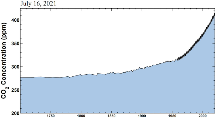
The Keeling curve tracks the changing carbon dioxide concentration in the atmosphere.
Observations from Hawaii starting in 1958 show the rise and fall of the seasons as concentrations climb.
Scripps Institution of Oceanography

Either way, Foote’s work remained lost to history until 2011.
That’s when the retired geologist Raymond Sorensen was looking through his personal collection of old scientific papers.
He found an 1857 report describing the oral presentation of Foote’s work, and realized in a flash that she’d preceded Tyndall …

“It was purely blind luck,” Sorenson says.
“I happened to read that page and knew enough to think, ‘Ah, that doesn’t fit with my understanding of the history of that concept.’”

Sorensen wrote a short paper noting Foote’s life and remarkable work, and pretty soon the academic world took note.
Scholars of science now increasingly credit her role in kickstarting this crucial area of science.

All of which makes me think: Damn, we theoretically knew about the risk of greenhouse gases one and half centuries ago? Ack! Imagine how much more gradually we could have adapted our energy production, if we’d assessed — many many decades ago — the impact of fossil fuels.

But of course, it’s not so simple.
Certainly, Foote and Tyndall and others documented how heat-trapping gases work.
But it wasn’t easy to envision just how rapidly CO2 emissions would ramp up, as the 20th century moved along.
And it really wasn’t easy to imagine all the cascading, complex, interdependent problems that warming climate would cause — like more violent weather, the migration of pests, you name it.
Indeed, scientists who followed in the footsteps of Foote and Tyndall welcomed the warming of the planet due to greenhouse gases.
They hoped it’d make for a better growing season.

Still, it’s impressive as heck to think that Foote predicted global warming so long ago.

Links :

Wednesday, May 3, 2023

One of UK’s largest seagrass beds discovered off Cornwall

Seagrass is one of the largest carbon sinks globally despite covering only 0.1% of the ocean floor.
Photograph: Matt Slater


From The Guardian by Steven Morris

Survey finds 359 hectares of rich habitat, a highly effective carbon sink, in St Austell Bay

One of the largest seagrass beds in the UK, home to seahorses, pipefish and scallops and a highly effective carbon sink, has been identified off the south coast of Cornwall.

Saint Austell bay in the GeoGarage platform (UKHO nautical raster chart)
 
An acoustic study of St Austell Bay carried out by a survey boat pinpointed 359 hectares (887 acres) of seagrass hugging the coastline, and divers sent in to examine the site close up recorded 56 species living in the rich habitat.

Cornwall Wildlife Trust described it as a hugely positive find but said work was needed to protect the bed and further surveys should be carried out to find out if there were other beds in nearby areas.

Abby Crosby, marine conservation officer for the trust, said: “The discovery of extensive surviving seagrass beds in St Austell Bay is a very exciting development.
Seagrass is one of the largest carbon sinks we have globally, despite covering only 0.1% of the ocean floor.
“It also serves as a shelter, feeding ground and nursery for a host of marine life, including vulnerable species such as seahorses, and the young of commercial fish and seafood stocks.
Seagrass beds play an important role in helping to combat erosion of the coastline from the waves, as storms increase in their intensity due to climate change.”

Seagrass meadows, which can flower and photosynthesise in shallow seas, are important because they stabilise the sediments in which they grow and provide food and shelter for other species thereby enhancing biodiversity.

They also sequester and store carbon in their leaves, branches and root systems, as well as in the sediment below and around them.
When seagrass meadows are stable and healthy, they can be highly effective carbon sinks.

Among the marine animals seen by divers in the seagrass were the short-snouted seahorse, broadnosed pipefish, little cuttlefish and scallops.

The volunteer divers also examined beds of maerl, delicate coral-like algae, a little further out from the coast, where they found an additional 66 species including the curled octopus and streaked gurnard.

Some areas within the beds were free of litter and other human impact, though rubbish – and a large number of golf balls hit errantly from a seaside course – and some old fishing gear were found in other places.

The St Austell Bay blue carbon mapping project is part of the G7 legacy project for nature recovery announced at the world leaders’ summit held in Cornwall in 2021.

A report on the project, published by Cornwall Wildlife Trust and Natural England, said that some poor weather and limited financial resources meant that not all the planned surveying work had been completed.
It says management measures to protect the seagrass and maerl such as making them more visible to sea users through marker buoys should be considered.

Seagrass beds are thought to have surrounded much of the UK before the Industrial Revolution but the wildlife trust said about 92% was lost in the last century.
The decline has been caused by pollution, disease and coastal development.
Additionally, damage from anchoring, moorings and dredging has affected the seagrass beds.

Crosby said the project was a “significant first step” in understanding the extent and quality of blue carbon habitats in the St Austell Bay area.

She added: “We look forward to collaborating with a wide range of people, from local residents to marine business and government organisations, to ensure we protect these special marine habitats which will benefit all marine life and our coastal communities into the future.”
 
Links :

Tuesday, May 2, 2023

Maldives wins maritime boundary dispute with Mauritius

Chart on how the Maldives-Mauritius economic zone was divided

Chart on how Maldives-Mauritius'overlapping territory will be divided


From Edition by Malika Shadid

Maldives' claim for a larger share of the disputed waters with Mauritius is upheld by the International Tribunal for the Law of the Sea (ITLOS).

Utilizing the equi-distance principle, ITLOS has made a determination to divide the disputed maritime zone between Maldives and Mauritius. 
However, the implementation of this principle has sparked controversy, primarily due to the necessary measurements that must be taken from Blenheim Reef to Mauritius.
 

Blenheim Reef, "Terra nullius" ?
 
Maldives has presented scientific evidence and satellite images to support their argument that the Blenheim Reef is not part of the coast of Mauritius.
In response to Mauritius' proposal to utilize the reef as a base point for drawing the equi-distance line, ITLOS' special chamber ruled it as inadmissible.
Despite being visible only during dry weather, the chamber has also decided to exclude any point from the Blenheim Reef while drawing the equi-distance line.

Maldives made an argument stating that the sovereignty dispute between Mauritius and the United Kingdom over the Chagos Archipelago was unresolved and fell beyond the purview of ITLOS's jurisdiction.
Despite Maldives' defense, ITLOS proceeded as required by the United Nations Convention on the Law of the Sea (UNCLOS), which grants each country a 200-mile continental shelf.
 
Blenheim reef with the GeoGarage platform (UKHO nauticalm raster map)
Blenheim Reef is a partly submerged atoll structure in the Chagos Archipelago, Indian Ocean.
It includes the coral reef of Baxio Predassa in its southeastern rim, plus another completely submerged part.

The disputed territory between the two countries covers an area of 95,000 square kilometers, and Mauritius proposed using the Blenheim Reef as a base point for dividing the border.
However, Maldives argued that the reef is not a dry land and thus cannot serve as a base point.
If it were considered as such, it would grant Mauritius an additional 4,687 square kilometers of territory, according to the proposed base point.

EEZ limits with the GeoGarage platform

ITLOS has allocated the disputed overlapping territory of 95,000 square kilometers between Maldives and Mauritius, providing each country with a 200-mile continental shelf.
Maldives has been granted 47,232 square kilometers while Mauritius has been given 45,331 square kilometers.

Mauritius received 0.960 square kilometers for every square kilometer received by Maldives.

Although the case has been resolved, it is worth noting that under the United Nations Convention on the Law of the Sea (UNCLOS), any natural extension of a country's continental shelf beyond 200 miles should be taken into consideration.
In 2010, the Maldives and Mauritius both approached the Commission on the Limits of the Continental Shelf (CLCS) to claim their share of the area beyond the 200-mile limit.
However, the matter remains unresolved at the CLCS.

Following the Maldives' independence in 1965, President Ibrahim Nasir entered into an agreement with Sri Lanka and India to divide the overlapping territories in the northern part of the Maldives.
However, the area of Chagos in the south has yet to be officially designated due to the British occupation of the islands.

On July 31, 1976, an agreement was signed between President Nasir's administration and Sri Lanka to separate the overlapping territory, and on December 28, 1976, a similar agreement was signed with India to separate the overlapping territory in the Arabian Sea.
However, the agreements did not come into effect until June 8, 1978. At the time of the agreements, none of the countries had a 200-mile special economic zone, so the overlapping territory was divided based on equidistance.

Links :


Monday, May 1, 2023

Image of the week : evening on the roaring forties


EVENING IN THE FORTIES
Marion Dufresne (supply and oceanographic ship of the TAAF), between Crozet and Kerguelen

Sunday, April 30, 2023

Sailing winter Norway


Sailing winter Norway with small sail boat and Igor Stropnik