Saturday, February 19, 2022

Storm Eunice: how forecasters predicted super-strong winds days before it even formed

Monster wave at Newhaven, East Sussex chasing storm #Eunice! (Caught at a safe distance)

From The Conversation by Hannah Cloke

Storm Eunice is in full flow as I write this and has already broken the record for the fastest ever gust recorded in England.
Before the wind even really got going here in Reading, where I work as a natural hazard forecaster, I had already watched my wheelie bins fly past my window (I since tied them down).


Comparisons are being made with previous storms, particularly the “Burns’ Day Storm” of January 1990, which killed dozens of people, and the October 1987 “Great Storm”.
Although less intense, Eunice may be meteorologically similar to the 1987 storm, with the chance of a “sting jet” – a rare but highly damaging phenomenon caused by a break between the warm and cold fronts in a storm.
This allows very fast winds, normally kept high in the atmosphere, to reach the ground and lash the surface like a bullwhip.

In 1987, the BBC weather forecaster Michael Fish was famously caught out by the severity of the Great Storm.
What has really changed since the late 1980s is the quality of our forecasting and warnings.
The steady improvement in weather and climate forecasting has been caused by unimaginably more powerful supercomputers, much better scientific understanding of the earth’s natural processes, and better communication of risks and early warnings.

credit : Ewan Lebourdais et Erwan Poirier

Let’s look at the forecasters’ achievement in the week leading up to Eunice, which hit the UK on Friday 18 February.
They had identified – and even named – both Eunice and its immediate predecessor Storm Dudley, on the morning of Monday 14 February.
At that point, scientists knew the conditions were right to create a storm, but didn’t know exactly how big or where it would go.

By Wednesday, there was enough certainty in the forecasts to issue weather warnings, telling people to get ready for possible serious disruption.
Remember, this is before the storm existed and hadn’t even begun to form out in the Atlantic.


By Thursday, with 24 hours’ notice, it was clear where the storm would be going and that the winds would be extremely strong.
This lead to a red warning – meaning “take action now” – for parts of south Wales and south-west England.
And early on Friday morning, south-east England and London were given red warnings too.

Days before Eunice hit the UK mainland, forecasters knew it would be very dangerous.
This was a level of detail and accuracy that was completely missing ahead of the Great Storm, meaning there was no early warning in that case. 

courtesy of Francis Fustier

Computers, data, communication

The improvement in the forecast is partly because of the hugely improved resolution of the supercomputer models.
We can now simulate the earth in great detail, in four dimensions (including time).
We also just have a better understanding of the science, and how conditions in the sea and air combine to create our weather.


But a very fast computer model can only create a forecast as good as the data you put into it.
That’s why our improved array of satellites, aircraft, balloons and good old-fashioned weather stations are critical to getting an accurate picture of what is going on.

The final issue is around communication, which has improved significantly in the past 30 years in the UK, thanks in a great part due to the establishment of the National Severe Weather Warning Service – the system that sets of yellow, amber and red warnings.

The more recent naming of storms, which began in 2015, also helps.
“Dudley” and “Eunice” may sound more like a kindly uncle and aunt, but the evidence shows naming storms works.
The Great Storm and Burns’ Day Storm were named not by emergency planners in advance, but by the media afterwards.


This is just one example of how forecasters and authorities need to take into account not just the quality of the science, but also how people respond to it.
As we saw during the floods in Germany last summer, the best forecasts in the world are useless if people don’t believe them, or don’t understand how to act to keep themselves safe.

Eunice storm with Weather 4d 
courtesy of Francis Fustier

With Eunice, it has been interesting to see how many local authorities, schools and businesses did almost nothing when the warning was “amber”, but then decided to close when it moved to “red”.
I’ve also seen people living in areas covered by the amber warning saying, “Phew – we’ll be OK.” That’s not true – amber areas can see damage and risk to life just as severe as the red areas.

There is still much more we can do to improve warning systems, but let’s realise how far we have come.
For now, the best advice is to take the warnings seriously, don’t take risks, and keep yourself and your family safe.

Links :

Friday, February 18, 2022

Shackleton's Endurance: Modern star maps hint at famous wreck's location

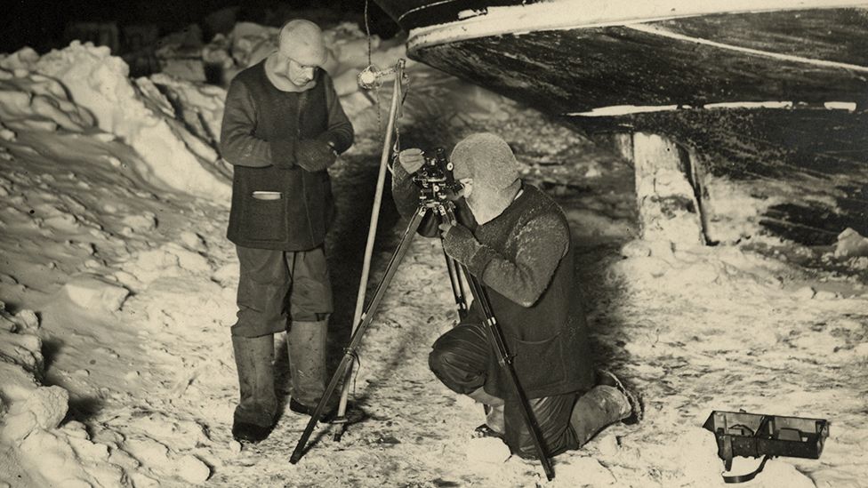
Image Source,University Of Cambridge/Spri
James and Worsley made observations of the stars and the Moon to calibrate their chronometers

From BBC by John Amos
 
For many, the lost ship of Antarctic explorer Sir Ernest Shackleton is the greatest of all undiscovered wrecks.

In part that's because of the extraordinary story that surrounds the 1915 sinking of the Endurance - an epic tale of 28 men who somehow survived and escaped the calamity of becoming stranded in the frozen wastes of the Weddell Sea.

But the allure also has something to do with the daunting challenge the wreck now presents to anyone who might consider trying to find it.

What remains of the Endurance is 3,000m down in waters that are pretty much permanently covered in thick sea-ice, the same sea-ice that trapped and then ruptured the hull of Shackleton's polar yacht.

You need a good strategy, immense skill and an enormous dollop of good luck just to get near the sinking location.
A team of hopefuls is on its way to the Antarctic right now.

There's an assumption we know well where the ship lies on the ocean bottom because Shackleton had a brilliant navigator on his ill-fated voyage, a man called Frank Worsley.
Using a sextant and chronometer, he calculated the coordinates for the position where the punctured Endurance slipped below the floes on 21 November, 1915.

It's in his log book. 68°39'30" South; 52°26'30" West.
 
 Endurance was crushed by the sea-ice and sank in 3,000m of water
Position given in the log book with the GeoGarage platform (UKHO nautical raster charts)
 
SA Agulhas II has stopped and they report that
they have reached their target area near the wreck of Endurance.
 
But how accurate is this?
Three modern-day researchers - Lars Bergman, David Mearns and Robin Stuart - have long pondered this question.

They've tried to sum the various errors that may have crept into Worsley's measurements and have concluded in a new pre-print paper that the true sinking position may be several kilometres to the east of where the navigator computed it to be.

"There's a lot of things to consider; you cannot just take Worsley's position for granted and go right to that location. You've got to use your judgement," said David Mearns who's found many historic wrecks in his career.

Mearns and his two colleagues have submitted their paper to the Journal of Navigation but have taken the decision to publicly release it now because it could be useful to the search that is about to get under way.

Longitude was worked out by comparing local time with Greenwich Mean Time

The paper's central concern is the performance of the marine chronometers, or clocks, used by Worsley to get a longitude fix.

Previous work by Bergman and Stuart had suggested these were running much slower than the crew of the Endurance had realised or accounted for - an error that would put the sinking west of Worsley's recorded position.
But Mearns has now picked up a really quite critical error in the clocks' calibration that pulls the location back and off to the east.

The investigation highlights the story of Reginald "Jimmy" James, the ship's physicist on Shackleton's Imperial Trans-Antarctic Expedition.

It was James who showed Worsley how he could work out the drift in the time-keeping of the chronometers from lunar occultations.


There's a picture of the two men at the stern of the Endurance observing stars as they disappeared behind the Moon.
The timing of these movements had been predicted and published in a nautical almanac.
Its tables kept the chronometers honest.
And it's fair to say that without the occultation observations, Shackleton's crew would have misjudged their location by many, many kilometres.

But here's the fascinating part in this story.
Modern maps of the sky are remarkably precise, far more so than the catalogues used to compile the almanac employed by James and Worsley.
Had the men been in possession of today's information, they'd have realised their clocks were actually running 22 seconds faster than they were accounting for.
Just this error would have put the Endurance more than 3km east of Worsley's log coordinates.

Shackleton's Imperial Trans-Antarctic Expedition

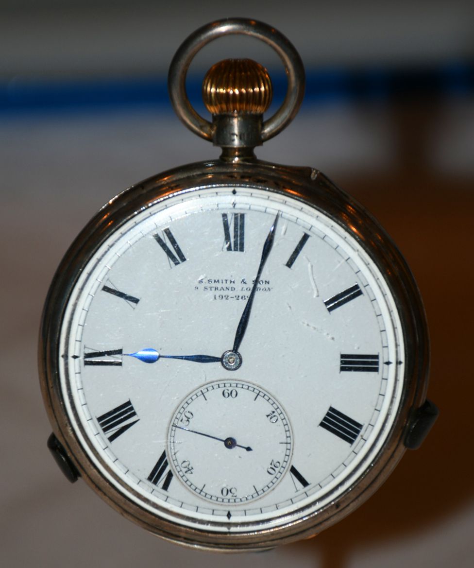
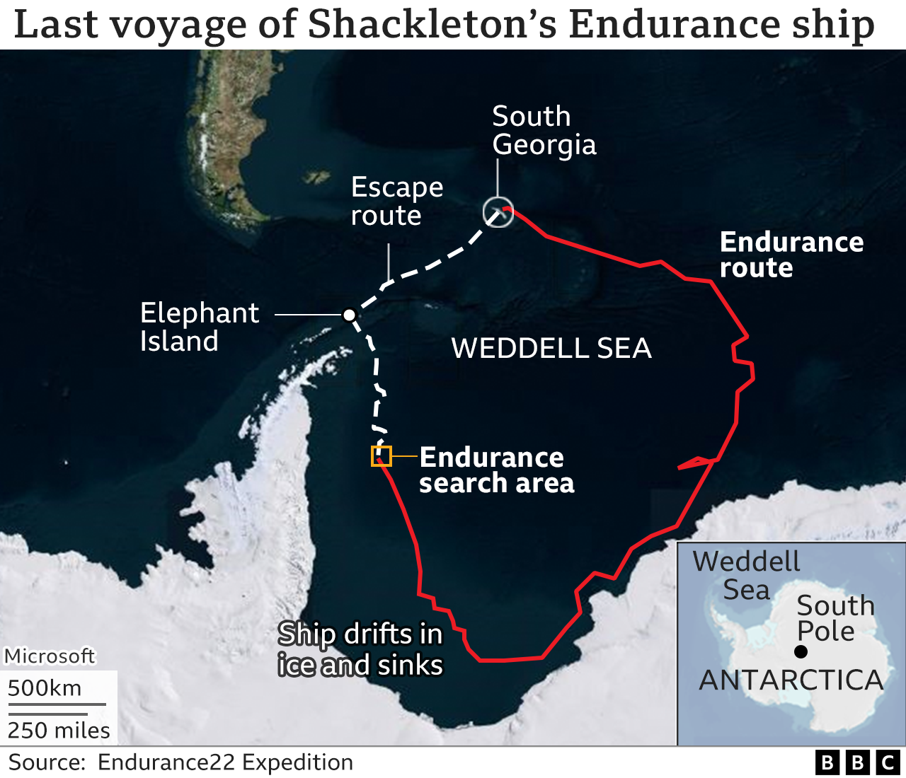
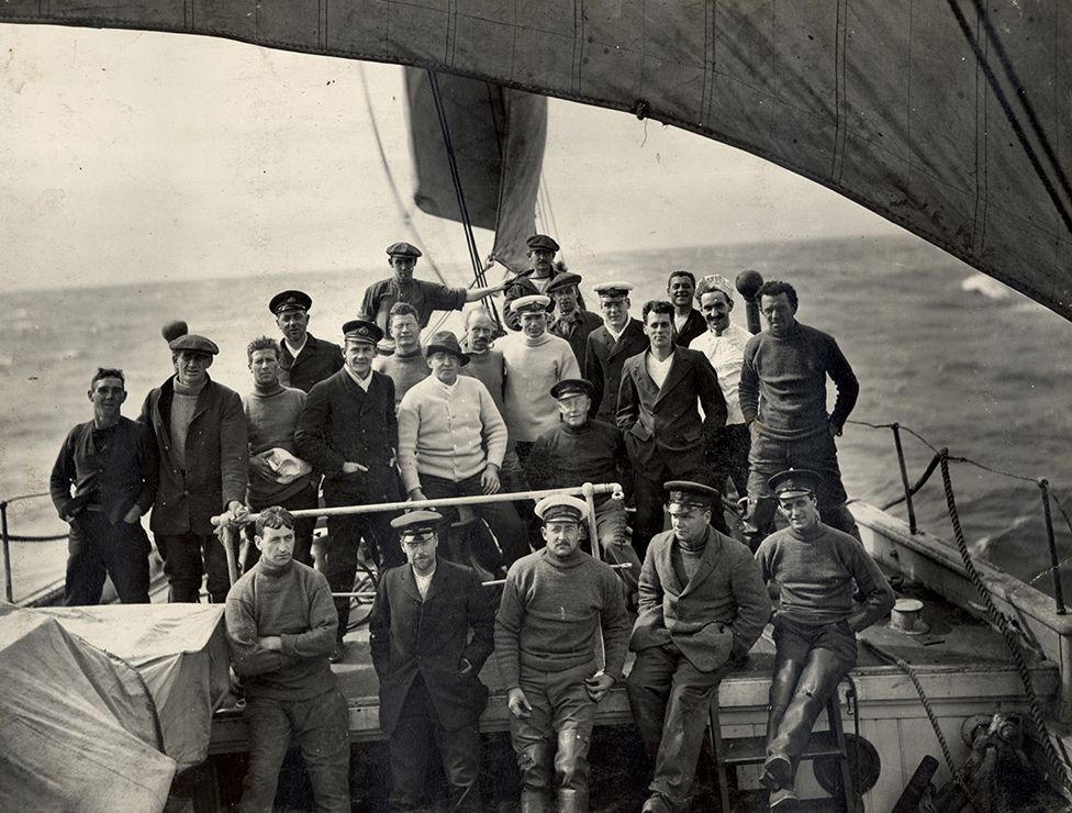
IMAGE SOURCE,SPRI/UNI OF CAMBRIDGEImage caption,
The entire crew survived the ship's loss in the ice

December 1914: Endurance departs South Georgia
February 1915: Ship is thoroughly ice-locked
October 1915: Vessel's timbers start breaking
November 1915: Endurance disappears under the ice
April 1916: Escaping crew reaches Elephant Island
May 1916: Shackleton goes to South Georgia for help
August 1916: A relief ship arrives at Elephant Island

However, this is but one uncertainty that needs to be considered when examining the reliability of those coordinates.
Not often recognised is that Worsley didn't get a fix on the expedition's position until fully 19 hours after the Endurance had gone down.
On the day of the sinking, a view of the Sun, needed to make a navigational observation, was impossible because of thick cloud.
And neither was it possible in the two days before the sinking. Worsley's coordinates rely on an estimate of the direction and speed of the shifting sea-ice during those three "missing" days.

Bergman, Mearns and Stuart are convinced, though, having looked at all the issues, that the real longitude is off to the east.
Their latest paper, they say is "a more complete, accurate and reliable basis for determining the most probable sinking location of Endurance".
It's been shared with the Endurance22 project which is currently headed into the Weddell Sea to look for the wreck with underwater robots.

The project's exploration director, the marine archaeologist Mensun Bound, said the paper had been read with interest, although he did not disclose whether its analysis would influence his team's thinking. Everyone must have their own assessment.


Interestingly, this past week has marked the 30th anniversary of the start of Ice Station Weddell (ISW). This was a joint US-Russian ice camp that came very close to the presumed sinking location.

"It was set up from the (Russian ice-breaker) Akademik Fedorov on a multi-year drifting ice floe near 71.4° South," recalls Laurie Padman from the Seattle-based Earth & Space Research institute.

"The camp's track paralleled the last days of Shackleton's Endurance in 1915. I spent several weeks at ISW, my first Antarctic 'cruise', as US Chief Scientist.

"We collected atmospheric, sea-ice and ocean data for about four months, before ISW was recovered near 66° South by the (US icebreaker) Nathaniel B Palmer," he told BBC News.

Beyond the crew of the Endurance and the Ice Station, very few people have ever ventured into the west-central Weddell Sea, one of the most inhospitable parts of Antarctica.

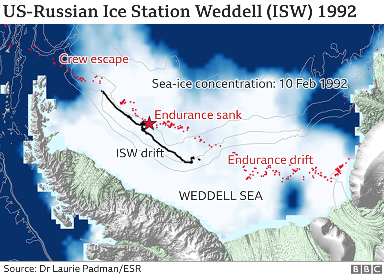
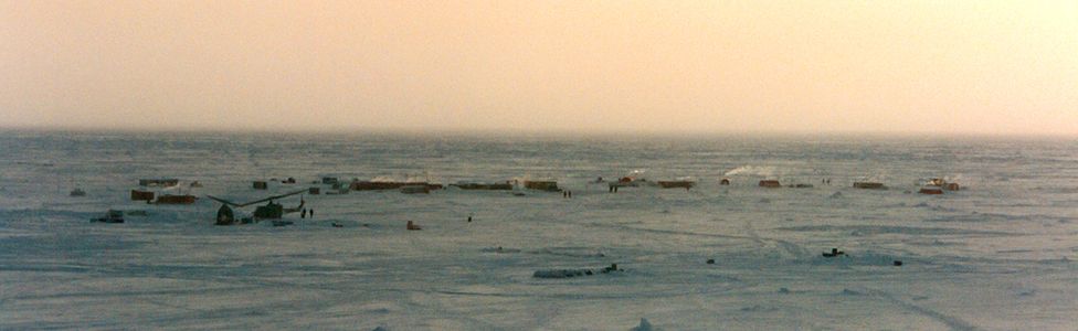
Image source, NSF/USAPI
Ice Station Weddell passed very close to the presumed sinking location

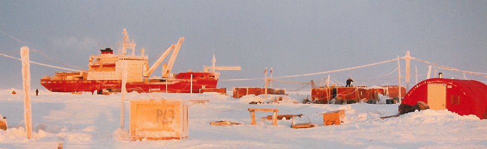
Image source, USAPImage caption,
The Russian icebreaker Akademik Fedorov set up the drifting ice camp 
 
Links :

Thursday, February 17, 2022

Four-story high rogue wave breaks records off the coast of Vancouver Island

 
The MarineLabs sensor buoy which detected the record-breaking rogue wave off of Ucluelet, British Columbia.

From CNN by Caitlin Kaiser and Tom Sater

(CNN)A rogue wave measuring 58 feet (17.6 meters) tall was recorded off the coast of Vancouver Island, breaking the record for proportionality at three times the size of surrounding waves.

"Only a few rogue waves in high sea states have been observed directly, and nothing of this magnitude.
The probability of such an event occurring is one in 1,300 years," said Johannes Gemmrich, one of the lead researchers on rogue waves at the University of Victoria.
The wave made a splash in the scientific community for being proportionally the most extreme rogue wave ever recorded.
Although it occurred in November 2020, the study confirming it was just released February 2 of this year.

A rogue wave is exactly how it sounds: unexpected and terrifying.

"They look like a large four-story lump sticking out of the water with a large peak and big troughs before it," Scott Beatty, CEO of MarineLabs, the company operating the buoy which measured the wave, told CNN.
In the past few decades, what was once known as marine folklore has now been accepted as real by scientists.
"Rogues, called 'extreme storm waves' by scientists, are those waves which are greater than twice the size of surrounding waves, are very unpredictable, and often come unexpectedly from directions other than prevailing wind and waves," the National Oceanic and Atmospheric Administration (NOAA) explained.
 

The MarineLabs rogue wave had a ratio of maximum height to significant wave height (Hmax/Hs) of 2.9, the highest ratio recorded to date.
The surface elevation signal was measured in two independent ways: a GPS based method and an IMU based method.
The conservative (smaller) Hmax of 17.6m was used for the study.

In simplified terms, "A rogue wave is actually just a wave that is large compared to the surrounding wave field," Gemmrich clarified.

Overall size doesn't matter, but the comparison in size to other waves does.
Thus, while a wave achieving a four-story height equivalent is impressive, its magnitude being three times that of its surrounding waves is what landed it in the record books.
The first rogue wave recorded, known as "The Draupner Wave," was measured in 1995 off the coast of Norway at 84 feet (25.6 meters) with surrounding waves of approximately 40 feet (12 meters), making the original rogue wave about twice the size of those around it.

The record-breaking rogue wave recorded in November 2020 measured at almost 58 feet (17.6 meters) in comparison to surrounding waves of around 20 feet (6 meters), blowing the original proportions out of the water.
 
The wave was measured via a MarineLabs buoy about 4.3 miles off the coast of Ucluelet,
Vancouver Island, British Columbia

Recording these "killer waves" is no easy feat 

The rogue wave in the study was measured via a MarineLabs buoy approximately 4.3 miles (7 kilometers) off of the coast of Ucluelet, British Columbia.

"We're a real-time intelligence company, and we provide real-time updates on what is going on along the coastline, including wind, waves, and other data," Beatty explained.
The company produced a video simulation of the buoy around the time the rogue wave came through, showing the swell in comparison to the smaller surrounding waves.

 
The problem lies in how to continuously track rogue waves once identified by a sensor.
"Most observations are at a single buoy, a single location, and so the wave passes through, and we know at this moment it was this high, but we don't know how long.
That is the big science question," Gemmrich noted.

One thing is known for sure: Rogue waves are not afraid to rock the boat.

Such waves can pose a significant threat to marine operations as well as the public due to their immense power and lack of predictability, Beatty stressed.

"They are unexpected, so the vessel operator has little warning.
If it is high enough that it can cause some damage to the vessel, the operator has no time to change course or react to it." Gemmrich added.

One common misconception Gemmrich wanted to emphasize is rogue waves are not to be mistaken for tsunamis.
Although both are known for being large waves, the way they come about is completely different.
"Rogue waves are generated by wind, so they are just a rare occurrence of wind generated waves.
Whereas a tsunami is generated most commonly by an earthquake, underwater earthquake, or as we've seen recently a volcano eruption," Gemmrich stated.

Coastal communities everywhere are vulnerable to rogue waves.
According to Gemmrich, anywhere exposed to water could experience a rogue wave, though places with strong currents may be more likely to see them.
As for Vancouver Island, there was no reported damage from the rogue wave, as it occurred too far offshore.
However, they can present onshore danger if they originate closer to the coast.

To ensure better safety in the future, the scientific community is pushing for better research and forecasting to help prevent any damage to maritime operations or the public.
Jennie Lyons at NOAA pointed out there are specialized distinctions for rogue waves.
A "sneaker wave" typically describes a rogue wave condition along the beach because it sneaks up on you.
Rogue waves out over open water much larger than those around it, are often called "freak" waves.
And rogue waves large enough to damage a ship or cause a ship to roll more than normal are called "killer waves," because if they are severe enough, the damage could capsize a ship, potentially killing people.
MarineLabs has a system of 26 buoys placed strategically in the oceans surrounding North America with hopes to more than double their number by the end of 2022.

"We are aiming to improve safety and decision-making for marine operations and coastal communities through widespread measurement of the world's coastlines," Beatty stated.
 
Links :

Wednesday, February 16, 2022

Can autonomous, seafloor-scanning robots speed up offshore wind development?


From Morning Brew by Greace Donnelly


Bedrock, an early-stage startup, wants to shrink the time it takes to map the ocean floor—a key step in rolling out wind turbines.
Francis Scialabba


Nearly every time humans go into the deep sea, we discover new species.
Scientists estimate that we have classified as little as 9% of all marine life.
And the mystery extends beyond life and to topography, too—at present, we’ve only mapped about 20% of the Earth’s seabed.

Making progress on the latter point—seafloor mapping—is crucial to measuring climate change and deploying ways to combat it.

“The data we collect connects to climate science, site assessment for wind-energy farms, site assessment for potential marine resources, habitats, fisheries, marine management—anything like that,” Rachel Medley, chief of the expedition and exploration division at the National Oceanic and Atmospheric Administration (NOAA), told Emerging Tech Brew.

Bedrock is building ocean drones to map the seafloor in an effort to help fill one of the largest knowledge gaps on the planet

But the process of scanning the seafloor is expensive and time-consuming.
Bedrock, a two-year-old, Brooklyn-based startup, aims to make the process up to 10 times faster with its electric, autonomous underwater vehicles (AUV) that can navigate along the ocean floor in waters up to 300 meters deep.
Bedrock is still in the early stages of testing this tech—it has only built one AUV so far—but it raised $8 million in a seed round last March and is hiring “aggressively” to grow the current team of ~20 full-time employees, its CEO and co-founder, Anthony DiMare told us.

To begin with, the startup is tailoring its tech to the seafloor-mapping needs of the offshore-wind industry, which is gaining some momentum in the US.
The Biden administration is pushing to add 30 GW of offshore wind power by 2030.
That would mean about 2,000 turbines along the coast of the US.
Right now, there are only seven.

Meeting that 2030 target could trigger $12 billion in annual investments in domestic offshore wind projects, and help accelerate wind power’s prominence in the US electrical mix, from about 8% today to 20% in 2030.

In addition to the one AUV in use now, another is being built.
Bedrock began construction on its own production facility in Richmond, California, at the end of 2021 and aims to build at least 25 of its AUVs by the end of the year, DiMare told Emerging Tech Brew.
These battery-powered AUVs can operate for 24 hours at a time and typically travel at speeds of about 2 to 3 knots (~2 to 4 miles per hour).

Bedrock surveys

Searching the seabed

Before any turbines go into the water, offshore wind developers have to determine the landscape of the seabed, catalog the species living in the area, and measure potential environmental impacts.

Seafloor mapping today requires deploying a large, manned ship and using sonar-equipped devices and autonomous surface vessels to collect data about water depth and temperature, as well as the landscape and sedimentary makeup of the ocean floor.
For offshore wind developers, this means a 200- to 300-foot, highly specialized ship that can operate 24 hours a day.

“We’ll start with a broad oceanographic survey that will include what we refer to as marine geophysical and geotechnical information,” Jesse Baldwin, head of US site investigation at offshore wind developer Ørsted, told Emerging Tech Brew.
“We’re collecting a lot of that remote sensing data.”

This initial survey usually takes about six months and the process costs tens of millions of dollars, Baldwin said.
DiMare believes Bedrock’s tech can address several of the bottlenecks in the current mapping process.


Bedrock

Rather than waiting weeks or months for a massive ship to sail to the area you need to survey, Bedrock’s AUVs are small enough to be shipped or even checked as luggage on a flight and can be launched directly from the shore without the need for a boat.

“I’m trying to help enable that at a 10 times faster rate than what they’re doing now,” DiMare said of Bedrock’s technology.
In other words, if the current process takes about six months, Bedrock aims to shrink that to about three weeks.

Medley, who co-chairs one of the interagency working groups collaborating on an effort to map the outer boundary of the US seabed by 2030, says AUVs can play a role in collecting seafloor data.
NOAA already uses autonomous technology for some tasks, but Medley doesn’t necessarily see them as a replacement for ships.

"All autonomous systems complement ship activities,” she said.
“And usually, you can use them as a force multiplier, to be able to achieve a broader goal, rather than just doing it with one particular platform."

And as more wind farms are built, companies will also need a way to check on the integrity of their turbines during construction and over their lifespan afterward.

“I do think that there is certainly going to be an avenue for companies like ours to use autonomous solutions in the future,” Baldwin said, with the caveat that these technologies will have to be able to meet Ørsted’s data quality standards.
For now, the company still uses traditional ocean survey equipment, which is either mounted directly to the ship or towed behind it, he said.

Bedrock says it’s currently working with one customer in the offshore wind industry as well as another renewable energy customer and ocean and earth science companies, but declined to name any clients.

Although the company is focused on offshore wind, AUVs could also be used to build the maps needed for ocean carbon sequestration, laying telecom cables, underwater data centers, and decommissioning oil and gas pipelines, Bedrock says.
And by getting its AUVs closer to the seabed, the company says it can use a higher-frequency sonar for these missions that is less likely to disturb marine life than the signals sent out by vessels on the surface.

Deep-sea data

Bedrock

Under the traditional methods, managing the enormous datasets collected by ships that don’t always have an internet connection can be slow and complicated.
Even onshore, sharing terabytes of seafloor mapping data among stakeholders can be cumbersome.

NOAA makes its information publicly available, but DiMare said his request for NOAA’s data on the seafloor off the coast of New York took three weeks and involved shipping physical hard drives.
NOAA told us hard drives are only used for large data requests, and even then only if a user explicitly requests the physical process rather than a piecemeal download.

Along with the AUVs, Bedrock says it is building a platform for its customers to more easily process and share the data collected about the seafloor, though it’s not technically possible to transmit the full datasets from their point of collection via today’s wireless methods.

“This will be one of the largest geospatial datasets in existence and we are collecting it in the least connected part of the world,” DiMare said.
“So the challenges will exist around figuring out how to manage fleets—thousands of [AUVs]—get them recharged, and then get data back to land, where we can use cloud systems to make intelligent decisions.”

If Bedrock is able to deliver on that vision—to build a system that can efficiently provide a detailed understanding of the bottom of the ocean—it could be a boon not only to business, but also to science more broadly.
The company is also involved in an international effort called Seabed 2030, that aims to map the entire ocean floor by the end of the decade.

DiMare hopes someday the world will have a fresh seafloor map each year.

“What is most exciting to me is we are going to find things and discover things and be able to do things that we’ve never been able to do before,” he said.
“There’s not too many other environments, spaces, data gaps of this magnitude, where you just don’t know what we’re going to find.”
 
Links :

Tuesday, February 15, 2022

The seamanship of going aground


From YachtingMonthly by Pete Goss

Many of us will have run aground at some point in our sailing life. Pete Goss examines intentional and accidental going aground and the best methods for getting off


Going aground, I suspect,is far more common than we think.
It’s one of those things that falls into the category where the measure isn’t the cock-up itself but the number of people that witness it.

Often private affairs, groundings are kept safely tucked away in the sheepish pen.
This is such a shame as lessons and reminders not being broadcast can fan further incidents.

In this article I will share some personal reflections and anecdotal incidents to open up the subject of grounding and hopefully stir an awareness of how to prepare or react.

It is a huge subject that could fill an entire book so my hope is that the touch points I examine and discuss here will encourage further reflection and the introduction of routines that can be drawn down with immediate effect.

Going aground intentionally

In areas that dry out, grounding, rather than being a dirty word becomes a daily reality.
This is where many lessons can be learned with the biggest influence being boat choice.

Bilge keels, lifting keels, centre boarders, legs and cradles.
My personal preference is the centre board because it can act as a sounding stick that simply pivots without serious impact on grounding.


Going aground happens to us all.
Being alert to the dangers and ready to respond is critical to how we fare when the inevitable happens.
Photo: Ben Sutcliffe-Davies

Centre boarders have the additional benefit of fixed ballast to fully maintain righting moment, even with the board up.
Unlike bilge keelers, good windward performance is maintained and the hull is low down for boarding when dried out.

This for me is the answer which leaves a fin keel if you are dead set on windward performance.
The best solution I have seen for drying out a fin-keeled boat on a regular basis is a cradle, of which there are good examples in Looe Harbour.

Against a wall

Beyond day-to-day berthing, reasons for drying out range from scrubbing the bottom, changing anodes, checking impellers and rudders, or sheltering from a storm.

To dry out a fin-keeled boat, it’s best to find a good wall to dry out against and locals will point you in the right direction.
I always check the site at low water to ensure the bottom is suitable and to measure the hull contact point for any obstructions in the wall.
This will also indicate whether a ladder will be required to access the coach roof once dried out.

At the same time I will put a position mark on the wall where the shrouds should line up.
Don’t forget to drain the water tanks to reduce weight and place movable ballast such as the anchor, life raft and sails towards the inner side deck to encourage a heel towards the wall.


Check at low tide before drying out a fin keeler.
Photo: Theo Stocker

A spinnaker halyard made ashore is essential.
A plank outside the fenders protects against a rough and uneven wall.
To avoid point loading the hull, I have round fenders to fill the widening gap as the hull curves away from the wall.

Bilge-keels

Bilge-keelers require a flat surface with easy access to the shore, preferably avoiding mud, which spreads like nothing else.
As an aside we had a Prout Snowgoose as a family banger which we continuously dried out, necessitating a hardwood shoe to protect the glass keels.

Most lifting-keel and centre-board craft settle bow-down, so I like to find a suitable incline to level the boat.
The most important thing here is to ensure that you’re made fast to the shore with the addition of a couple of anchors out to sea.

One of these should be much further out than the other so that you can raise the first and then use the last to drag yourself well offshore.
If the engine fails, this offers sufficient room to drop it again.
On this note, pay attention to the forecast – the wind might not be in quite the same direction when you re-float.

In a similar vein, pay close attention to the swell forecast; I’ve known big swells arrive out of a perfectly calm blue day which can work their influence well inland.

I always call the local harbour master to check for the possibility of wake.
I remember a yacht that was just about to float outside a French fishing port when a rush of trawlers headed out at full throttle for the morning catch.
It was awful to watch as the boat bashed away for an hour.
The trawlers, despite being called on VHF and waved down from a dinghy couldn’t give a monkeys.

It’s worth noting here that the worst kind of impact for a keel is vertical shock loads with the boat dropped onto the seabed by waves.
The loads drive straight up into the structure with nothing to dissipate the impact, such as the bow dipping down when hitting the bottom when under way.
The result is often catastrophic.


Looe Harbour in Cornwall has cradles for fin keelers to take the ground

This happened to a friend of ours and was exacerbated by a deep rudder that also hit the bottom to take out the rudder bearings.
We’ve resolved this on our new boat with lifting rudders.

Storm protection

There are many reasons for drying out, from maintenance to simply enjoying the upper reaches of a river or creek.
One that is rare but should be kept in mind is storm protection.

In hurricane areas there is nothing like a mangrove swamp to dissipate waves and offer lots of secure points to which you can make fast.

Some of our big UK depressions warrant hiding away and our estuaries are littered with handy little mud creeks to nose into.
One thing I would warn against is being stranded above the high water mark by a storm surge.

I have recced a few spots along the south coast that would suit our boat should a hundred-year storm show its face.
Sheltered from wind in all directions, out of the main channel where flooding rain water can generate strong currents, beyond falling trees and with plenty of strong points to which you can moor.

Going aground unintentionally

While it may be obvious that avoiding grounding in the first place is covered by the practice of good seamanship, within that catch all phrase, I think it worth highlighting a few pointers that I have found to be helpful.

Navigation is key and talking to a number of insurance companies a common suggestion is to carry paper charts.
I wouldn’t put to sea without an electronic chartplotter – they are wonderful – but I still treat them as an aid to traditional methods.
True, we spend a lot on charts but I wouldn’t be without them and evidence would back this up.

You only have to study the Team Vestas Wind disaster during the Volvo Ocean Race to see the hidden risks that come with electronic charts.
Here was a top line boat filled with some of the best sailors and navigators in the world and yet they sailed straight into a reef at full speed.
It beggars belief until you dig a bit to realise ‘there but the grace of God go I’.
I always ask ‘What would I do if our power went down?’ and so I carry everything required including a Walkers towed log.

Planning risk


When passage planning I mentally project a colour-coded risk assessment across the plan.
This visual reference highlights areas that require extra concentration, as it is so easy, particularly when tired, to creep into a vulnerable area without realising.

In really dodgy areas I’ll actually pencil a boundary that, when crossed, must prompt a higher state of alertness with the skipper on deck, a crew briefing and the implementation of appropriate procedures such as a crew member at the bow, kedge anchor rigged and dinghy launched.
It can also include areas of no-go in darkness.
Red areas require the passage plan to be checked after a night’s sleep.

The overriding rule of thumb is to listen to your instinct, ‘if in doubt stay out’.

Navigational error

It’s essential to keep a regular log recording barometric pressure, wind direction and position.
An hourly plot on my chart provides a helicopter view and often highlights hazards that can be hidden by layering on a chart plotter.


Some shallow harbours and anchorages are worth taking a calculated risk to reach.
Photo: Pete Goss

Use of a simple handheld compass is a terrific and easy way of checking things.
I lay off an approach bearing and use the main compass to check things are lining up as they should.
This practice came from a cruise in the Baltic when we arrived soon after a late thaw thanks to a delayed spring.

Making down the centre of a perfectly buoyed channel towards a marina we were shocked to run hard aground.
Fortunately it was soft mud and we were able to reverse out on a rising tide.

It wasn’t until I took a bearing that we realised the winter ice had shifted the markers to the east a hundred metres before perfectly re-laying them as the ice thawed.
On the hard was a yacht that had suffered the same fate at six knots on a falling tide.
Out of desperation they decided to drive back into the channel through the mud with the helm hard over and engine revs at full power.
When they discovered this wasn’t enough they got the harbour master to tow at 90º off the bow and collectively generated enough torque to tear the hull away from the keel.

If ever there was a lesson in the fragility of both navigational aids and of a yacht’s structure being asked to withstand that for which it wasn’t designed, then here it was.

This fragility was later underlined as I made a night approach in bad conditions to an unknown harbour. I was grubbing around searching through the mist and sheeting rain, stopwatch in hand, for a light flashing three in 10.
To my great relief it popped up in a lull and was confirmed by the stopwatch.

Shortly afterwards I noticed surf under the bow and just managed to turn back to sea, heart in mouth.
It turned out that three cars, with a fourth following
10 seconds later, had driven round a tight bend.
I saw what I wanted to see and nearly lost a yacht.


Once aground, protecting the boat from further damage is the main consideration.
Photo: Nigel Calder

The first example underlines the benefit of traditional skills, and the second the benefit of a chart plotter.
 
Taking risk

There are times, under the right circumstances, that warrant taking on a greater risk of grounding.
There are some amazing shallow anchorages and passages that are a bit close to the bone.

I have used a drone to tease out a passage through a narrow rock-strewn inlet in Maine. At low water I’ve set my own withies using branches.
In the Scilly Isles I’ve walked a tidal passage using a handheld GPS to provide waypoints for the plotter.
In the right circumstances and conditions these are fun and rewarding exercises.

Other causes Common causes of groundings beyond navigational error are loss of power, loss of steerage, dragging the anchor and swinging into shallows.
Solutions should be thought through from emergency steering to auxiliary power.

On our Garcia Exploration 45, Pearl of Penzance, we could drop the dinghy outboard onto the transom. In the case of our new boat, Oddity, we have two lifting rudders to avoid damage and offer complete redundancy.


Many estuaries offer deeper pools across shallow bars. Anchor off and inspect by dinghy first if you are unsure.
Photo: Nigel Calder

Make sure you have a well-serviced engine with a dedicated and annually-tested start battery.
Years of happy sailing breeds complacency and, if not prepared, circumstances can quickly escalate.

We had a huge lump of fishing net stop our engine dead as we rounded a particularly dodgy headland in southern Brittany.
We were an hour behind schedule and the tide was carrying us onto the rocks.
Fortunately I had left plenty of sea room, my mask, snorkel, fins and knife were ready and I was over the side in a flash.
A close call, with preparation saving the day.

Harbourmasters are always sweeping up boats after a storm and, from my time spent working on the tugs in Plymouth, the majority could have been avoided with better maintenance of ground tackle below and improved chafe protection above.
If you are expecting a gale or leaving the boat for a long period then shackle your anchor chain to the mooring.

Unintentional Groundings – Response

Should you go to ground under way or at speed, crew safety comes first, followed by extraction from the situation.
Check the crew; a common injury of a dead stop is broken ribs.
I always sleep feet forward to save my neck. MOB is also common so a quick crew count is imperative followed by donning life jackets.

Check the keel bolts and keel matrix for damage and bilges for water, taste it in case the issue is ruptured water tanks.
Check the bulkheads, looking for crazed gelcoat.
Be thorough, as shock loads can travel to odd places before delivering their final destructive blow.
Check the engine mounts before powering up the engine and slowly build the revs feeling for unusual vibrations.


Do not be tempted to put crew in a vulnerable position.
Lifting a laden dinghy will be far more effective in getting the boat to heel and reduce the keel’s draught.
Photo: Lester McCarthy/YM

It’s common for the rig to be damaged so whip round the chain plates, scan the rig with binoculars and give it a good shake.
If you’re not stuck fast, make for calm waters as soon as possible to reduce keel loads.

In a seaway raise the main to steady the boat and avoid wrenching the keel about.
After any grounding, no matter how soft, the boat must be lifted for a thorough check of the hull, keel and rudder.

Most insurance policies will cover the lift and survey, whether there is damage or not.
If you track back from a lot of keel losses there will often be an un-checked grounding hiding in its past.


If any work boats are available locally, their extra weight and horsepower might help pull you off. Photo: Graham Snook/YM

During the Three Peaks race we bounced on the bar at Ravenglass and during a later gale found that the keel box had started to separate from the hull.
Every time we came off a wave the box moved and sprayed water across the cabin.
We had done a thorough ‘on the ground inspection’ but on reflection we should have retired and lifted her.

If chartering I dive on the keel to check for surface damage and insist on a lift out if needs be.
It’s just not worth the risk.

Falling tide

It’s not until you have gone aground on a falling tide that you realise how quickly the levels fall.
It’s horrifying; there’s no time to think and barely enough to act.
Routines need to be in place with equipment to hand for immediate deployment.

Check the tide; if you’re lucky and it’s rising, put all the crew on the bow and try to back off. Launch the dinghy to circle the boat with a lead line to establish the best escape route.
I am told there are very good hand-held echo sounders but have no experience of them.

Top up the kettle before running the fresh water tap to clear the tanks.

Heel the boat

If the above doesn’t work, heel the boat.
Putting people on the boom makes them vulnerable and has limited effect, so hitch up the dinghy to the spinnaker halyard, chuck in sails, kedge anchor, crew and any easily-moved equipment.


Use whatever is to hand to protect the hull from rough ground.
Photo: Kieran Flatt/YM

I set the spinnaker pole out with a guy fore and aft to stabilise it.
The halyard is then run though a bowline on a rope that returns inboard through the pole end.
Once the boat has heeled enough for gravity to take the halyard beyond the radius of the pole the line can be released.

Make sure the dinghy fastenings can take the load or, in the case of an inflatable, have webbing strops.
Once the boat is heeled try and motor off but be aware that the engine might not be picking up as much oil from the sump as it should.

All this must be done in the blink of an eye so practise it and have it already set up if you suspect you might be caught out.

Get people to assist

In the Bahamas, we helped a yacht off a bar with 10 dinghies and a fishing boat off the spinnaker halyard.
The fishing boat pulled the guard rails under whilst the rest of us pushed in the direction we wanted the boat to go.

All pretty agricultural but it saved the boat thanks to a clear plan and some forthright leadership to create a cohesive effort and quell a thousand daft ideas.


1Shock loads can travel and dissipate in hidden corners, such as the keel matrix bonding, or bonded-in bulkheads, as above.
Photo: Nigel Calder

Staying put

If you can’t get off accept it and swiftly move into phase two.
As Einstein said, ‘stupidity is repeating the same action and expecting a different outcome’.

Radio the authorities, heel the boat up the incline – a kedge anchor off the spinnaker halyard is good for this.
It might sound daft but I always contact the designer to make sure that hatches will remain above the water as the tide rises.
If this is not the case, carry hatch boards and some tubes of silicone.

Lighten the boat by taking gear ashore.
Lay out anchors so the incoming tide doesn’t carry the boat further inshore.
Put ropes under the hull so that you can secure fenders from both top and bottom at the point of contact.

It might sound drastic but if the ground is rough, utilise sails, cushions and locker lids or internal doors. You’ve just gotta do what you gotta do; I have a friend who walked ashore, borrowed shovels from a farmer and spent six hours digging a channel between the hull and deeper water to great effect.

Call for help

The rule of thumb is to expend as much energy into getting afloat as the tide allows.
Success can rest on the smallest detail and it’s too late if you ‘just don’t quite make it’.

If none of the above works then it’s time for phase three which necessitates dispassionate assessment. Is a Pan Pan or Mayday appropriate?
Call the insurers, maintain the log and take pictures.
Call the authorities for support in extracting the crew, salvaging equipment and removing environmentally hazardous materials such as fuel and gas.

Discuss drastic measures such as the RNLI or a trawler simply dragging her off. In dire straits you might require a helicopter as in the Scillies with Storm Evert.
In remote areas you might be stranded for a while so consider communications, food, shelter and warmth ashore.
 
Links :

Monday, February 14, 2022

What rowing solo across the ocean teaches you about solitude

 
"I was inspired to write this book by the coronavirus crisis, and the many people who are struggling with feelings of fear, isolation, and loneliness. I spent up to five months completely alone when I was rowing solo across oceans. My feelings of aloneness and fear were very real. I had to find coping strategies, and eventually came to appreciate solitude as a pathway to emotional maturity and self-reliance."
[Photo: Flickr user Bytemarks]
 
From Fastcompany by Judith Humphrey

Roz Savage rowed solo across three oceans, so she knows a thing or two about isolation—and resilience.

Roz Savage has rowed solo across three oceans—the Atlantic, the Pacific, and the Indian—in a small boat.
She earned four Guinness World Records.

She was alone at sea up to five months at a time, journeys she recounts on her website, and in her new book, The Gifts of Solitude. 
The insights she provides about solitude are powerful ones, especially for anyone dealing with isolation during the COVID-19 pandemic.


In 2005, Roz Savage quit her high-powered London job to become an ocean rower.
She's crossed the Atlantic solo, and just started the third leg of a Pacific solo row, the first for a woman. Why does she do it?
Hear her reasons, both deeply personal and urgently activist. 

I interviewed Savage recently and drawing upon her experience at sea, she offers seven practical tips for anyone sheltering at home:

1. BREATHE

First, delight in slow, deep breaths.

“I discovered the power of breathing when I was rowing across the Atlantic Ocean,” says Savage. “There were so many life-threatening situations that made me panic. For example, when the boat’s electrical system went down or the winds were blowing fiercely, or when my four—and only—oars broke, I felt panic-stricken. I would take deep breaths, and that would calm me.”

Panic is a natural response to the pandemic. 
“But by breathing, we can each dissipate that fear,” she says. 
“We can only take one breath at a time, and that breath is always in the present. So breathing deeply situates us in the moment and prevents us from worrying about the future.”
 
2. HARNESS YOUR INNER VOICE

Second, take control of your inner voice and make it your ally, not your opponent.
“During times of crisis,” Savage explains, “we may find ourselves battling with the voices in our head. When we are alone, we are brought face-to-face with our inner voices, which can be harsh.”

“When I was rowing, I struggled with these voices,” she said, “especially in the Atlantic, my first voyage. Then one day another ocean rower sent me a lovely message: ‘It’s lucky you’re tougher than most.’ His words inspired me, and I actually rowed to those words. With each oar I pulled, I said to myself, ‘Tougher than most.’ It became a soothing mantra.”

That advice is useful for all of us.
Whether your mantra is “I’ll get through this,” or “This is an opportunity for me to be courageous,” find an expression that reflects your best sense of self.
Get your inner voice on your side.
 
3. REACH OUT –AND CONNECT

Savage rowed solo across the three oceans, but satellite phone communications kept her in touch with her friends and shore team.
She posted daily blogs from her boat to share her adventures with old and new friends.

While we’re unfortunate to live in a world with COVID-19, we’re fortunate to live in a time when we have so many ways to connect with family, friends, and colleagues—from postings on social media to Zoom and FaceTime.
None of these portals is the same as in-person contact, but they are a good antidote to being alone.
So use them.

Pick up your phone and call those you care about
 Call an old friend and say, “I’ve been thinking of you,” or contact family members and tell them you love them.
All this goodness is a gift of solitude, so take advantage of it.
 
4. FOCUS ON WHAT YOU CAN CONTROL

Fourth, focus on what you can control, and try to move beyond the areas you can’t.

Savage told me: “When I was on the boat I tried to control the ocean, but that didn’t work. Some days I could go 36 miles without a single oar stroke. On other days I could row 24 hours straight and not even go 36 miles. I couldn’t control the winds, waves, and currents. But what I could do was show up and row for 12 hours each day. I focused on that.”

Bring order to your life, even though the world remains a distressing place.
Set a schedule, as Savage did, and follow it.
Make sure it includes things like exercise, reading, eating, family, entertainment, and whatever gives you pleasure and a sense of fulfillment.
Commit to something you can control.
 
5. TALK OUT LOUD, SING, DANCE, BE SILLY

Next, cultivate your sense of humor.
“When I was rowing,” Savage says, “it was hard sometimes to laugh. But one day when I was feeling quite depressed I looked at myself—completely naked, as ocean rowers often are, with only a sun hat and rowing gloves on, singing along with Abba’s “Dancing Queen,” . . . blaring away in the middle of the ocean. I thought, ‘This is so ridiculous.’ I just had to laugh.”
 
6. EMBRACE NATURE

Sixth, find beauty and comfort in nature.
“I found . . . that nature can be harsh, but it also was my entertainment, especially after my stereo broke,” says Savage.
“It inspired me, especially looking at the night sky, gazing at all the stars, whose light I realized took thousands of years to get to us. . . . My own personal frustrations seemed very small.”

When you feel overwhelmed, look to nature.
Take pleasure in the sight of birds, enjoy a romp with your dog, or the spring flowers.
Relish the beauty of your natural surroundings.

7. LEARN WOOLGATHERING

Seventh, practice “woolgathering”—a lovely term that refers to daydreaming.
It comes from the practice of gathering the loose tufts of wool on bushes, left by passing sheep.

“In the middle of the ocean, it’s easy to daydream,” Savage says.
 “There’s not as much sensory input as we have on land, where we’re bombarded with media, conversation, and tight schedules. When there isn’t as much coming into our heads, there’s an opportunity to think freely, to dream.”

When we are alone or sheltering in place we have an opportunity to become childlike and more open to the wonders of life.
Enjoy the chance you have to be away from your normal routine.
Spend time dreaming.
 
Links :

Sunday, February 13, 2022

Kelly Slater - 2022 PipeMasters at almost 50

The GOAT steals the Pipe Show once again 
Internationally renowned surfer, Kelly Slater, has won the 2022 World Surf League's Billabong Pro Pipeline title in Hawaii just a week before his 50th birthday.