
Saturday, September 16, 2023
Friday, September 15, 2023
Champagne, caviar and perilous waters: Have cruises become too adventurous for their own good?
 Ocean Explorer remains aground after attempting to free itself and a fishing boat attempted to pull it free (SIRIUS/Arctic Command photos)
Staggeringly beautiful, but treacherous and highly dangerous in the wrong circumstances, the relatively unexplored coast of Greenland has become one of the most sought-after prizes for expedition cruises.
In the maritime world, this Danish territory is one of the remotest places on earth, with vast swathes of its eastern coastline uncharted, leading mariners to note ironically that the surface of the moon has been better documented than the waters around these parts.
In the maritime world, this Danish territory is one of the remotest places on earth, with vast swathes of its eastern coastline uncharted, leading mariners to note ironically that the surface of the moon has been better documented than the waters around these parts.


Alpefjord in the GeoGarage platform (DGA nautical raster chart)
But the thrill of sailing into such an unknown wasteland, populated by polar bears and musk oxen, is a key part of its appeal for the new generation of expedition cruise ships now venturing into this isolated region.
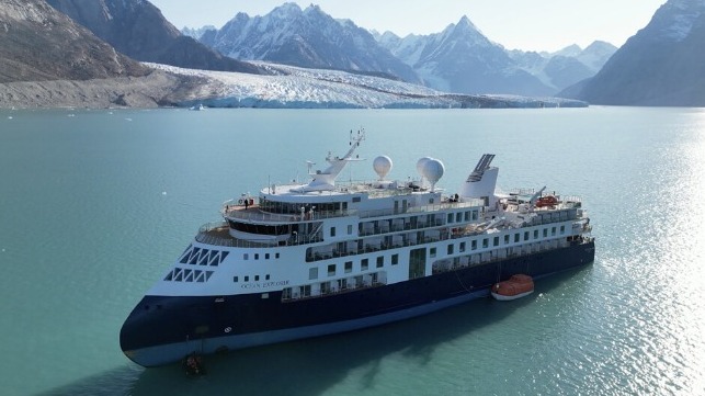
The MV Ocean Explorer, a Bahamas-flagged Norwegian cruise ship with 206 passengers and crew, which has run aground in northwestern Greenland is seen on Tuesday, Sept. 12, 2023.
(SIRIUS/Joint Arctic Command via AP)
This week’s news that expedition ship Ocean Explorer has run aground in Alpefjord, high up on Greenland’s east coast in the Northeast Greenland National Park – an area that is almost the size of France and Spain combined and with no permanent human habitation – struck a personal chord with me.
Cruise ship that charges $33,000 per person is stuck in Greenland’s Arctic
CREDIT: DANISH AIR FORCE/ARCTIC COMMAND
I was in the vicinity just a few weeks ago aboard luxury expedition ship Seabourn Venture that departed Iceland’s capital Reykjavik to explore Greenland’s eastern and western coasts during an unforgettable two-week voyage.
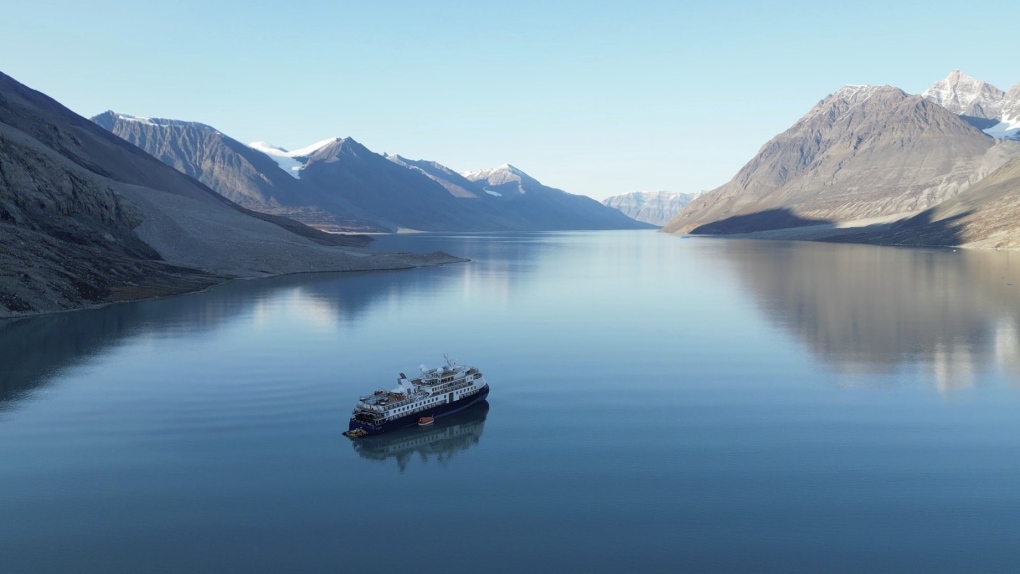
Our first stop was Scoresby Sound, which sits slightly south of Alpefjord, bordering the southern flank of the national park.
This network of giant fjords stretching for 68 miles dwarfs its better-known contemporaries in Norway, with towering cliffs hundreds of feet high, separated by azure ribbons of glaciers and vast winding waterways.


source : Maritime Bulletin
Due to this summer’s heavier than usual ice floes, caused by a greater amount of ice breaking away from the Greenland Ice Sheet, which covers nearly 80 per cent of the landmass (an area three times the size of Texas), ours was the first ship to enter the fjord system this year as it was previously icebound.
What greeted us was a study in frozen magnificence, with icebergs majestically floating like a procession of giant sculptures carved into intricate shapes by the elements.
For Seabourn Venture’s British captain Simon Bishop and his bridge team, such beauty is laced with potential peril, commanding vigilance at all times.
Explaining the lack of nautical charts detailing Greenland’s east coast, he explained: “We are dealing with data from the 1960s, mainly because the infrastructure of the east coast is poor so there is a lack of detail.”

Mighty glacier in the Alpe Fjord, East Greenland
While Greenland’s west coast is covered by more thorough digital navigational aids, Seabourn Venture’s bridge crew plotted its eastern route by pencil using a traditional paper chart which showed only limited routes through Scoresby Sound where the channels and depths were recorded.
Having been launched by US line Seabourn last year, Seabourn Venture has the latest technology to help it navigate these areas and is one of the first ships equipped with a special ice radar to help it to detect such hazards.
Another tool at its disposal is a forward-looking sonar, which enables the ship to enter uncharted waters. This works with a Zodiac boat sailing ahead of the ship, carrying a special wide-angle multibeam camera that scans and maps the seabed, creating 3D images transmitted straight to the bridge.
On our voyage, it enabled us to explore uncharted waters on a couple of occasions, but heavy ice floes still meant a planned island stop had to be abandoned as it was considered unsafe.
Wherever we went on this voyage, there was no doubting that safety was always the uppermost concern of the officers and crew.
Travelling on such a ship, where our complement of 181 passengers was surrounded by luxurious touches, with no shortage of caviar and champagne, it is also deceptive, enabling travellers to experience the pristine beauty of this environment while insulating them from the rawness of the elements.
Travelling on such a ship, where our complement of 181 passengers was surrounded by luxurious touches, with no shortage of caviar and champagne, it is also deceptive, enabling travellers to experience the pristine beauty of this environment while insulating them from the rawness of the elements.
There are no shortage of luxurious touches aboard Seabourn Venture
“We are travelling on what is like a spaceship, drinking champagne and in the remotest region of the world, yet in the harshest environment and it is easy to forget this,” said the ship’s expedition leader Fridrik Fridriksson.
How Ocean Explorer, which was sailing for Australian cruise operator AE Expeditions (known outside the UK as Aurora Expeditions), ran aground on Monday afternoon is not known.
This modern ship, launched in 2021, is described as having “the latest cutting-edge technology, sustainability and navigation capabilities”.
A statement from the company said the 206 passengers (mainly Australians, but with some Britons), the expedition team and crew were safe and well and in no immediate danger, with ample supplies.
However, such is the remote location that according to a statement from the Danish military’s Joint Arctic Command, its nearest available inspection vessel Knud Rasmussen was 1,200 nautical miles away and could not reach Ocean Explorer until Friday at the earliest.
JAC’s head of operations, Brian Jensen, is quoted by Reuters as describing the situation as a “worry” as the nearest help was so far away and the weather could be unfavourable.
CREDIT: Sara Macefield
“However, in this specific situation, we do not see any immediate danger to human life or the environment, which is reassuring,” he said.
Bloomberg reports that two attempts by the ship to free itself on high tides have failed.
Adventure cruising has been one of the fastest growth areas of the cruise market in recent years with the expanding number of ships equipped with the latest technology pushing back the boundaries of expedition cruising.
According to CLIA, the cruise association, the number of passengers sailing on expedition voyages more than doubled between 2016 and 2022.
Akvile Marozaite, co-founder of the Expedition Cruise Network, said AE Expeditions’ ships are “some of the most technologically advanced ships in the sector” and that the grounding was an “incredibly rare and unlikely event”.
But with an increasing number of ships sailing into ever-more remote regions it raises the question of what happens if and when something goes seriously wrong.
As Captain Bishop said: “The challenges in Greenland are the ice and being so remote. That means we have to be prepared for the unknown.”
Links :
- AP : A cruise ship with 206 people onboard has run aground in Greenland / Stranded luxury cruise ship MV Ocean Explorer has been pulled free at high tide in Greenland
- Maritime Executive : Efforts fail to free cruise ship grounded in remote, Northern Greenland
- Bloomberg : Freed Cruise Ship Shows Risks of More Traffic in Remote Arctic / Luxury Cruise Ship Gets Unstuck After Four Days in Greenland’s Arctic
Thursday, September 14, 2023
Why does the prime meridian pass through Greenwich?

The traditional Greenwich Meridian (dashed line) goes through the Royal Observatory of Greenwich and the actual zero meridian is a bit off (solid line).
Image credit: Malys et al., Journal of Geodesy 2015 / Google Maps/Infoterra Ltd/Bluesky
Image credit: Malys et al., Journal of Geodesy 2015 / Google Maps/Infoterra Ltd/Bluesky
From El Pais by Rafael Clemente
In the past, the zero meridian used to be established coinciding with the last known land, beyond which there was only unexplored ocean
For centuries, the problem of determining the position of a ship on the high seas was a difficult one, although latitude and longitude pose two very different difficulties.
Latitude is measured with respect to a very clear reference point: the Equator.
On the other hand, for longitude there is no specific starting point, since all meridians are the same.
Latitude could easily be established simply by measuring the height of the North Star above the horizon (in the Southern Hemisphere, the Southern Cross offered an acceptable if not nearly as accurate substitute).
During the day, the reference was the Sun, although the calculation required some corrections according to the time of day and the time of the year, and was therefore only within the reach of trained professionals.
Longitude was another matter.
The concept of a “meridian” did not appear until the 16th century.
Medieval navigators calculated their course by dead reckoning or by applying “recipes” drawn up by cartographers.
These routes established nautical days between origin and destination, guided by the wind or following a given parallel.
Needless to say, these specialists guarded their knowledge (and their business) so jealously that once the routes had been established on their navigation charts, they used to give the client a simple indication of the directions to follow in each section of the voyage and erased all the annotations made on their maps so they could reuse it.
In the past, the zero meridian was established using the last known land, beyond which there was only unexplored ocean.
It seems that Ptolemy used the Canary Islands or, more likely, Cape Verde.
All longitudes were measured from there to the East, since the meaning of negative numbers was not yet widespread.
Columbus was the first to notice that the compass needle did not point due north, but as he moved across the Atlantic, the deviation decreased until magnetic and geographic north coincided.
There was nothing special about that meridian; it just seemed like a “natural” way to establish a reference.
Although the method of determining longitude at sea by magnetic declination would not be practical due to irregularities in the magnetic field.
The Treaty of Tordesillas, which established the zones of Portuguese and Spanish influence in the New World, only prescribed that the demarcation line would be found 370 leagues to the west of the Cape Verde Islands.
Much more than the 100 leagues established the previous year by papal bull, but no specific reference to degrees of longitude.
Geographers engaged in endless discussions about how many leagues were covered by one degree.
And later, if the line (defined as “from pole to pole”) extended to the other hemisphere, since the areas of the Pacific that could be colonized depended on it.
For many years, Cape Verde would serve as a more or less official reference point for the zero meridian.
In the middle of the 16th century, Mercator transferred it to the island of Fuerteventura, but that was not a universal agreement either, since each cartographer used to assign the meridian where it best suited him for practical, nationalist, or religious criteria.
Thus, the origin of longitudes was located briefly in Jerusalem, Rome, Pisa, Saint Petersburg, the Great Pyramid of Cheops, and Copenhagen (perhaps in homage to Tycho Brahe).
In the 17th century, Cardinal Richelieu decreed that France would adopt the meridian that used the island of El Hierro, at 19º 55′ West, which would then be rounded to 20º only so that 0º would pass through Paris.
For a long time, longitude could only be calculated by astronomical methods.
Lunar eclipses offered a good system: they occurred simultaneously throughout the planet, but each observer saw them at a different time, depending on their geographical position.
Columbus himself tried twice during his second and fourth voyages; although the few events available at the time did not offer many guarantees.
Other astronomers, including Galileo, suggested using a very accurate cosmic clock: the eclipses of Jupiter’s satellites.
Calculation tables were compiled to help with the task.
In theory, it might have worked on dry land, but locating them from the heaving deck of a ship at sea was impossible.
By the eighteenth century, the calculation of longitude was still an unresolved problem.
The methods were estimated by determining the position based on the course and path taken, which resulted in errors of tens of kilometers.
It was the cause of numerous tragedies: there were captains who were unable to find their reference islands and were so lost that they did not know if they were to the east or west, while, in the meantime, half the crew died of scurvy; or shipwrecks like the one in the Scilly Islands in which the British navy lost four ships of the line and more than two thousand lives in a single night.

Following these incidents, the British Admiralty promoted the search for a more reliable system for calculating longitude.
At least with an acceptable margin of error.
For a long time it was known that the solution was to compare the local time with the time at the reference meridian, but since there were no reliable clocks, it had to be calculated by other methods.
The most commonly used was lunar distances.
In essence, it was based on measuring the angle between the center of the moon and a bright star.
The stars were fixed, but the position of the Moon changed throughout the night.
Astronomers could calculate how it varied minute by minute and record the results in tables referring to a reference meridian.
In general, of course, the same one from where the calculations had been made.
It was certainly a formidable job, requiring the collective effort of several generations of mathematicians.
Because it was not only about predicting distances, but also helping with the multiple corrections that would be required.
For example, the effect of refraction caused by the atmosphere or the different apparent size of the Moon depending on whether it was at its apogee or perigee, which, in turn, affected the determination of its center.
It was the fifth Astronomer Royal, Nevil Maskeline, who, with the publication of the Nautical Almanac (1767), would give a great boost to the method of calculating lunar distances.
It was not a fast or convenient system: it required complex calculations that could take more than four hours to reach an acceptable result.
Maskeline himself, during a trip to the island of Saint Helena, took eight hours.
Around this time, an amateur watchmaker and carpenter named John Harrison built the first marine chronometer that was accurate enough to keep time to within a few seconds of error, despite the rough conditions of a sea voyage.
With its help, the calculation of the length was not only quick and easy, but much more accurate.
The downside to Harrison’s watch was its price, since it was a genuine piece of precision manufacturing.
So, until it became more affordable over time, sailors continued to use the method of lunar distances.
And since the Almanac tables had been calculated from the royal observatory in Greenwich, its meridian (and its local time) became a “de facto” reference.
In the second half of the 19th century, the need to adopt a common reference became more and more evident, not only because of navigation imperatives, but also to unify railway timetables.
In the United States, each population center was governed by a schedule that referred to its own meridian, taking Washington as its origin (which had also served to establish the limits of numerous states in the Midwest).
After several attempts, in October 1884 an international conference was convened in Washington with, among other things, the purpose of officially defining the Greenwich meridian as the origin of longitude measurements.
The agreement was adopted by 23 votes to one.
Only the Dominican Republic voted against; France and Brazil abstained.
In fact, France would still resist accepting the pre-eminence of Greenwich for thirty years, to the point of resorting to the euphemism “Paris mean time minus 9 minutes and 21 seconds.”
Links :
- IFLScience : Why Is The Greenwich Meridian Not Where It Should Be?
- RMG : The Prime Meridian
- GeoGarage blog : Opinion: How the Prime Meridian changed the world / Farewell Greenwich Mean Time / Lines of Longitude explained, with maps / 22nd October 1884: International Meridian Conference in ...
Wednesday, September 13, 2023
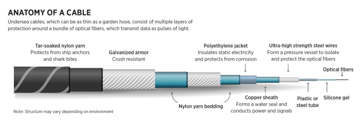
The Coast Guard should lead to protect undersea cables
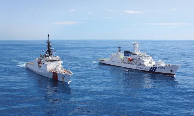
The Coast Guard cutter Kimball (WMSL-756) and Japan Coast Guard ship Akitsushima operating together in February 2021.
The Coast Guard,
alongside partner nations, could use a national security cutter and a
seagoing buoy tender with an embarked law enforcement detachment to
provide a tactical counter to Chinese vessels threatening undersea
cables.
U.S.
Coast Guard Diffuse Authority
Coast Guard Diffuse Authority
From USNI by Lt Andrew Nidbala & Ryan Berry USCG
Tonga, an island nation in the Pacific, lost almost all contact with the rest of the world for five weeks in early 2022.
The eruption of an underwater volcano severed its only submarine cable, effectively halting financial transactions, trade, and tourism.
The only outside contact was provided by a weak satellite signal with an hours-long queue.
Devastating both Tonga’s economy and its people, the blackout also proved the vulnerabilities of undersea cables.
Now, imagine a similar scenario involving Guam, but during a conflict.
Home to a critical U.S. military contingent, this U.S. territory remains lightly defended, especially considering “war games often predict early and sustained Chinese missile strikes on Guam” in the event of military conflict.
Now, imagine a similar scenario involving Guam, but during a conflict.
Home to a critical U.S. military contingent, this U.S. territory remains lightly defended, especially considering “war games often predict early and sustained Chinese missile strikes on Guam” in the event of military conflict.
A coordinated severing of the cables connecting Asia, Hawaii, and the rest of the United States could cause an information blackout that could devastate Guam’s economy and significantly handicap the U.S.
military’s regional capabilities and command and control.
Consider a second, gray zone scenario: Chinese fishing vessels coordinate a cable-severing operation and “inadvertently” damage the undersea cables connecting Taiwan to the outside world.
The island’s internet-reliant infrastructure, communications, and trade snap to a halt as satellite internet is wholly overwhelmed, and a quasi blockade involving Chinese fishing vessels and its maritime militia obstructs private industry’s repair vessels.
To provide support, the United States is faced with the strategic dilemma of initiating military action against ostensibly nonmilitary targets if diplomatic efforts fail to bring an acceptable resolution.
After a blackout lasting several weeks, China offers to fix the issue and fully integrate Taiwan with the mainland, effectively consuming the island without a direct military confrontation.
As basic necessities increasingly demand internet connections, damage to these undersea cables threatens both national and global security in a way the United States has not yet determined how to mitigate.
However, the U.S.Coast Guard could be a balanced, high return-on-investment solution.
By designating the Coast Guard as the lead agency for the undersea cable risk, the United States can align strategic and tactical preparations with operational capability to better prepare for and respond to potential threats.
As the leader of the Global Maritime Operational Threat Response (MOTR) Coordination Center, the Coast Guard should identify specific organizational responsibilities and develop plans to counter the undersea cable threat instead of treating the issue as one requiring only a general threat response.

High Risk, Low Security
Undersea cables carry about 95 percent of the world’s transnational internet traffic and support trillions of dollars in daily financial transactions.5 They are largely taken for granted, however, particularly as new satellite constellations such as Starlink are developed.
Satellite internet is critical, but its weak signals and limited capacity mean it will never be a sufficient alternative.6 The complex international politics of the ocean further cloud the issue and create a veil of secrecy exploited by bad actors worldwide.
Though discussed in limited circles, issues in the maritime space usually garner public attention only after serious incidents or disasters.
Unintentional physical damage is the most common hazard to undersea cables.
Within the current network of more than 500 cable lines, more than 100 cable breaks occur annually, primarily because of fishing and anchor gear damaging and/or pulling up cables.
Natural disasters also pose a threat.8 The Taiwan earthquake in 2006 disrupted business and communication throughout East and Southeast Asia.
Natural disasters also pose a threat.8 The Taiwan earthquake in 2006 disrupted business and communication throughout East and Southeast Asia.
The repairs required almost half the cable-servicing vessels around the world.
Unintentional electronic threats pose perhaps the least danger to undersea cables but can expose potential vulnerabilities.11 Examples include software bugs involving cable remote-management or landing-station systems.
Though correctable with timely software updates, electronic vulnerabilities could be exploited by bad actors.
Intentional threats, whether physical or electronic, are commonly treated as black swan events, but the coordinated sabotage of the Nord Stream pipeline in September 2022 underscores their reality.
Both historic wartime examples and recently severed cables in northwest Europe, Vietnam, and Taiwan show what a targeted, yet deniable, physical attack might look like.
A cable break caused by a shipping container in the Mediterranean in 2008 temporarily halted nearly all U.S. military communications and remote operations in Iraq.
One consideration is the attempted decoupling of U.S. adversaries from existing undersea cable networks.
China has become a serious competitor and is using its state-sponsored Digital Silk Road to decrease its reliance—and that of other countries—on U.S. undersea cables.
One consideration is the attempted decoupling of U.S. adversaries from existing undersea cable networks.
China has become a serious competitor and is using its state-sponsored Digital Silk Road to decrease its reliance—and that of other countries—on U.S. undersea cables.
The threat of China intentionally severing U.S. cables while using domestic networks to partially shield itself and others from collateral harm is increasingly concerning.
For the United States, responsibility for responding to threats to undersea cables below the strategic level is spread among an amalgam of agencies and involves a notable absence of operational leadership.
At the strategic level sits Team Telecom, chaired by the secretaries of the Departments of Homeland Security (DHS) and Defense (DoD) and the Attorney General and advised by other cabinet-level leaders.
This team has taken decisive action to support U.S. national security interests through undersea cable contracts and licensing, but efforts at the strategic level alone are not enough to mitigate U.S. and allied vulnerabilities.
At the tactical and operational levels, the United States has no coherent response vision.
The Federal Communications Commission (FCC) is responsible for licensing cable landings in the United States, but it has called for a lead agency in undersea cable protection and response.
At the tactical and operational levels, the United States has no coherent response vision.
The Federal Communications Commission (FCC) is responsible for licensing cable landings in the United States, but it has called for a lead agency in undersea cable protection and response.
An internal working group called for the FCC to “liaise with the U.S. Department of Homeland Security, which serves as the lead agency for critical infrastructure protection in the telecommunications sector.”
DHS is officially responsible under the National Infrastructure Protection Plan (NIPP), but the organization’s lack of publicly published acknowledgment or plans, which are arguably necessary given the complex, multinational nature of the problem at the intersection of public and private interests, indicates absence of preparation.
The United States’ cable security fleet (CSF) consists of two subsidized, on-call cable vessels.
The creation of the CSF under the Maritime Administration was a significant step forward, but as discussed in an October 2022 Proceedings article, its future remains unclear.
The United States’ cable security fleet (CSF) consists of two subsidized, on-call cable vessels.
The creation of the CSF under the Maritime Administration was a significant step forward, but as discussed in an October 2022 Proceedings article, its future remains unclear.
The CSF’s seemingly standalone nature, uncertain future, and limited assets make its ability to coordinate a prompt and appropriate response questionable.
A recent Congressional Research Service (CRS) report highlights the need for a comprehensive solution.
While discussing DHS’s planning deficiencies, it also recommends Congress consider appointing “a lead agency to coordinate undersea telecommunication cable security.”
A recent Congressional Research Service (CRS) report highlights the need for a comprehensive solution.
While discussing DHS’s planning deficiencies, it also recommends Congress consider appointing “a lead agency to coordinate undersea telecommunication cable security.”
This CRS report and several U.S. think tank analyses underscore the international nature of this vulnerability.
A Comprehensive Solution
For such a comprehensive issue, a lead agency must be multifaceted.
As a maritime agency, the Coast Guard has domestic and international authorities in both peace and war.
It is integrated into DHS, DoD, and the intelligence community.
The Coast Guard has a rich history of supporting maritime commerce and infrastructure.
It is responsible for the Marine Transportation System (MTS) under the NIPP.
While the current Maritime Commerce Strategic Outlook includes electronic systems supporting vessels and port infrastructure, under the MTS, undersea cables are also information technology infrastructure. The Coast Guard has acknowledged this nexus while expanding into the cyberspace domain.
Its Cyber Strategic Outlook includes undersea cables within its definition of the MTS.25Furthermore, because DHS is the responsible agency under the NIPP, the Coast Guard should embrace this leadership role.
A maritime threat issue requires leadership from a maritime organization, and the Coast Guard is the only service or agency with the right balance of capabilities and authorities.
And while the MOTR plan provides excellent single-crisis coordination and response, the MOTR community does not plan for, train for, and respond to long-term strategic threats such as those involving undersea cables.
This demands specific agency designation, preparation, and response capabilities.
The Coast Guard offers the best, most practical solution.
Potent Operational and Organizational Capabilities
On the water, the Coast Guard’s specialized cutters and crews provide a range of capabilities.
On a daily basis, cutter commands and crews apply legal authority in complicated jurisdictional environments, solve novel problems during search-and-rescue and other missions, and coordinate on-scene efforts with numerous agencies with differing authorities.
Because of the wide range of scenarios facing undersea cable disruption and response, and especially considering the unique circumstances surrounding public and private responsibility for undersea cables, the Coast Guard offers the most practiced mariners capable of leading a response at the scene.
The Coast Guard’s shoreside functions are similarly tailored for this leadership role—it has premier experts in both maritime response and investigation.
Any Coast Guard operation also involves a group of specialists coordinating logistics from shore.
Response experts are literate in cyber threats and operational conditions, trained under the Incident Command System (ICS), accustomed to applying skills and authorities across agencies, and experienced in planning emergency responses and coordinating multinational efforts.
In addition, the Coast Guard regularly investigates maritime incidents, both in its law enforcement capacity and during official inquiries into large-scale events, such as the recent pipeline disruption off Southern California. The Coast Guard is well positioned at the intersection of several commercial, military, and intelligence communities.
The value of the Coast Guard’s independent representation in the intelligence community merits emphasis.
The unique demands of such a complicated subject as the undersea cable threat and the catastrophic danger of cable destruction or sabotage require high-level coordination, specifically involving intelligence collection and threat identification.
While the Coast Guard is interoperable with DoD forces for most military operations, especially during war, it is a peacetime law enforcement agency.
This has proved particularly effective in the Pacific, where the Coast Guard has embarked on a relationship-building campaign.
Imagine the 2006 Taiwan earthquake under Coast Guard leadership.
The Coast Guard could have immediately coordinated with private industry and developed a thorough understanding of the necessary logistics and timelines.
Japan and the Philippines could have assisted with this planning because they are at either end of the severed cables.
This early coordination would have informed and tailored diplomatic efforts.
Alongside partner nations, a Coast Guard national security cutter and a seagoing buoy tender with an embarked law enforcement detachment could arrive with repair vessels to provide a tactful counter to the Chinese vessels, as well as enhanced logistical support for the repair efforts.
In a similar future situation, the national security cutter’s intelligence capabilities would likely prove invaluable.
Seagoing buoy tenders could enhance logistical support capabilities and augment the law enforcement presence.
While still a dangerous international situation, the Coast Guard’s prompt response could help navigate the crisis and avoid escalation.
Initial Steps
The United States cannot continue to neglect cable security, especially in the current decade of increased competition and gray zone conflict.
The following actions would help lay the groundwork for a coordinated threat reduction:
1. Senior Coast Guard leaders should consider vulnerabilities and possible scenarios vis-à-vis national security and weigh the gain of a practiced response.
2. The Coast Guard should establish a working group to examine requirements to assume lead responsibility for undersea cable threat response. The theme should be operational success in both gray zone and wartime circumstances. At a minimum, this group should:
- Determine requisite information and its sources for proper response planning
- Determine the number of specialized U.S. ships that could contribute to repair operations, including government and private-sector assets
- Examine integration points with other agencies and the private sector
- Propose internal Coast Guard responsibilities
- Recommend an initial plan of action to establish Coast Guard leadership in undersea cable response
Threats to the undersea cable network are incredibly vast and complex, and as adversary gray zone actions and posturing become more frequent, the United States cannot afford to rely on only the thinly stretched private sector.
The exposure may be small, but it is growing, and the consequences of poor response could be grave.
Undersea cable vulnerability can no longer be overlooked, especially when the cost of entry at the federal level involves little more than assigning the mission to an existing, high-performing service—the U.S. Coast Guard.
Links :
- The Diplomat : Navigating China-US Subsea Cable Competition
- India Today : Report says India sniffing internet traffic passing through undersea cables, raises surveillance risk
- PBS : NATO moves to protect undersea pipelines, cables as concern mounts over Russian sabotage threat
- FT : Threats to undersea cables should worry business as well as government
- Reuters : U.S. and China wage war beneath the waves – over internet cables
- Oodaloop : Undersea Telecommunications Cables and the Seabed are Geopolitical Contested Arenas
- GeoGarage blog : The threat to world's communications backbone
Tuesday, September 12, 2023
New hurricane forecasts could predict terrifying explosive intensification
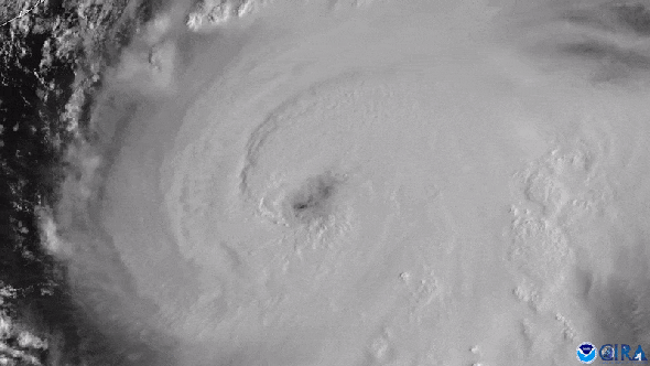
Hurricane Laura underwent rapid intensification over the Gulf of Mexico before it struck Louisiana as a devastating Category 4 storm on August 27, 2020.
Its maximum sustained winds jumped in strength by 63 miles per hour over the previous day.
It was the strongest tropical cyclone to hit the state since Hurricane Camille in 1969.
Its maximum sustained winds jumped in strength by 63 miles per hour over the previous day.
It was the strongest tropical cyclone to hit the state since Hurricane Camille in 1969.
Credit: CIRA/CSU & NOAA
From Scientific American by by Martin J. Kernan
Hurricane forecasters are debuting a new model they hope will better predict when some storms will suddenly and explosively intensify.
Virginia Key sits on Florida’s doorstep, just southeast of downtown Miami, and is firmly in the strike zone of Hurricane Alley—a swath of warm water that is perfect for hurricane formation and stretches eastward across the Atlantic to Africa.
More than 250 hurricanes have hit the U.S. mainland since the mid-19th century, often with catastrophic results.
Virginia Key is also home to the National Oceanic and Atmospheric Administration’s Oceanographic & Meteorological Laboratory, where scientists are hard at work to constantly improve hurricane forecasts.
One of their most pernicious longtime problems is the difficulty of predicting when a relatively minor-seeming storm will suddenly explode in strength and severity—a phenomenon that often takes those in harm’s way by surprise.
“We go to bed, and we see that a storm looks very ragged on the satellite.
And yet we wake up the next morning, and all of a sudden, it’s intensified,” says hurricane researcher Sharanya Majumdar of the University of Miami’s Rosenstiel School of Marine, Atmospheric, and Earth Science, also located on Virginia Key.
“So we all ask, ‘Why did that happen?’”
The answer isn’t always clear, which makes rapid intensification (which meteorologists define as a hurricane’s maximum sustained wind speeds spiking by 35 miles per hour or more over 24 hours) exceedingly difficult to predict.
Accurately predicting a hurricane’s intensity is particularly important, however, because storm force multiplies exponentially with wind speed.
When wind speed doubles, the force exerted on homes, power lines and other infrastructure quadruples.
And studies suggest that more storms will undergo rapid intensification—and do so at faster rates—as the climate warms.
The Hurricane Analysis and Forecast System (HAFS) “moving nest" Model.
Global map showcasing land mass in green and water in black, clouds in white and tropical storms outlined in a green boxes representing the moving nest model.
(Image credit: NOAA)
Now, equipped with a new model that took more than three years to develop, NOAA scientists think they will not only be able to provide earlier warnings of rapid intensification but also better predictions of impacts such as rainfall and storm surge.
Forecasters at the National Hurricane Center will begin using the new model, called the Hurricane Analysis and Forecast System (HAFS), this summer.
“We can’t improve the forecast fast enough, in my mind, to overcome the quadrupling of people living in [coastal] areas in a 15-year period,” says Frank Marks, director of hurricane research at NOAA’s Atlantic Oceanographic and Meteorological Laboratory.
One of the most sobering cases of rapid storm intensification was Hurricane Charley in 2004.
Warnings went up along Florida’s southwestern coast well in advance of the storm.
For about 24 hours before Charley hit, it was forecast to strengthen from a Category 2 to a Category 3 storm.
But in just five hours on August 13—and less than six hours before landfall—the storm’s winds shot up by 34 mph.
By the time it struck Captiva Island in Florida, it had 150-mph winds, just a few miles per hour shy of Category 5 status.
It was the strongest storm to hit Florida since Category 5 Hurricane Andrew decimated the city of Homestead in 1992.
Charley caused more than $15 billion in property damage, and only its small size and relatively fast forward speed kept it from being far more destructive.
“Any time a storm undergoes intensification close to land—but especially if that intensification is underforecast or not forecast at all—the public is at much greater risk because they will be underprepared,” says hurricane researcher and modeling expert Kristen Corbosiero of the University at Albany.
“Thus, the potential loss of life and damage to infrastructure will increase substantially.”
Certain key factors determine whether a tropical cyclone (the broad term for a tropical storm or hurricane) forms, how strong it can get and how quickly it ramps up.
The engine that powers every tropic cyclone is convection: enormous volumes of moist, rising air create a vacuum at the surface that sucks in surrounding air as spiraling winds.
This convection is fueled by warm ocean waters and high humidity, whereas dry air cools a storm through evaporation and impedes convection.
Calm skies must also prevail because crosscutting winds called shear can rip holes in a nascent hurricane’s vortex.
So getting information about a storm’s environmental conditions “is very important—but it’s not sufficient to say for certain if rapid intensification can occur or not,” says John Kaplan, a NOAA research meteorologist.
Credit: CSU/CIRA & NOAA
A storm’s internal physics are also crucial to the process.
For example, if the thunderstorms around its center are very symmetric, the pressure “drops like a rock,” Marks says—and the lower the center’s pressure, the higher the winds swirling around it.
Corbosiero, who is not involved in the HAFS work, explains that such symmetry keeps the heat released by developing clouds trapped in the eye wall of the storm.
This, in turn, fuels more convection.
The cylindrical eye wall of the hurricane must also remain straight up and down, not tilted.
If it tilts, the heating spreads over a larger area, and the pressure drop isn’t as dramatic, Corbosiero says.
Limitations in capturing these internal processes with models meant that as recently as the early 2010s, forecasts predicted only 12 percent of rapidly intensifying tropical storms.
Over the following decade, scientists were able to use extra funding from Congress to dispatch drones and crewed “hurricane hunter” aircraft to gather more data on wind speeds, humidity and temperature directly from storms’ eye walls.
This more detailed data let computer models more accurately depict—and therefore predict—storm behavior, helping meteorologists improve their forecasts.
Current models accurately predict rapid intensification 32 percent of the time, according to Mark DeMaria, a former NOAA hurricane forecaster and now a senior research scientist at Colorado State University.
“The inherent predictability of rapid intensification may be low,” DeMaria says, because small, unobservable changes in how a vortex develops may have an outsize impact on when the phenomenon occurs.
Equipped with HAFS, forecasters hope to improve their record by catching at least half of rapidly intensifying storms.
HAFS provides more detailed representations of a storm’s internal dynamics and more data to work with, and it can also incorporate those data faster than current models do—meaning forecasts can be updated more often.
Another key innovation involves “nesting” the HAFS model inside the larger Global Forecast System (GFS) model, where HAFS scans the ocean like a magnifying glass at higher resolution than previous hurricane models.
This nesting lets forecasters tackle another major challenge: reckoning how large-scale atmospheric features, such as cold fronts and high-pressure zones, influence a hurricane’s internal physics.
“A cold front somewhere in a different region of the globe might influence the track and intensity of a hurricane,” says NOAA senior meteorologist and chief HAFS architect Sundararaman “Gopal” Gopalakrishnan.
HAFS becomes officially operational on July 1, which means that forecasters at the National Hurricane Center may rely on it for guidance, along with other models, in making their predictions this summer.
Gopalakrishnan says he is excited to see how HAFS performs and expects it to do a much better job than the model it’s replacing.
“We’re going to be watching it like a hawk,” Marks says.
Links :
- Wired : The Rapid Intensification of Hurricane Lee Is a Warning
- Scientific American : How Hurricanes Jova and Lee Rapidly Exploded into Category 5 Storms
- NOAA : NOAA launches new hurricane forecast model as Atlantic season starts strong
- Nature : For essential weather predictions, look to the cloud
- GeoGarage blog : NOAA launches new hurricane forecast model
Monday, September 11, 2023
Unidentified golden specimen captures public imagination
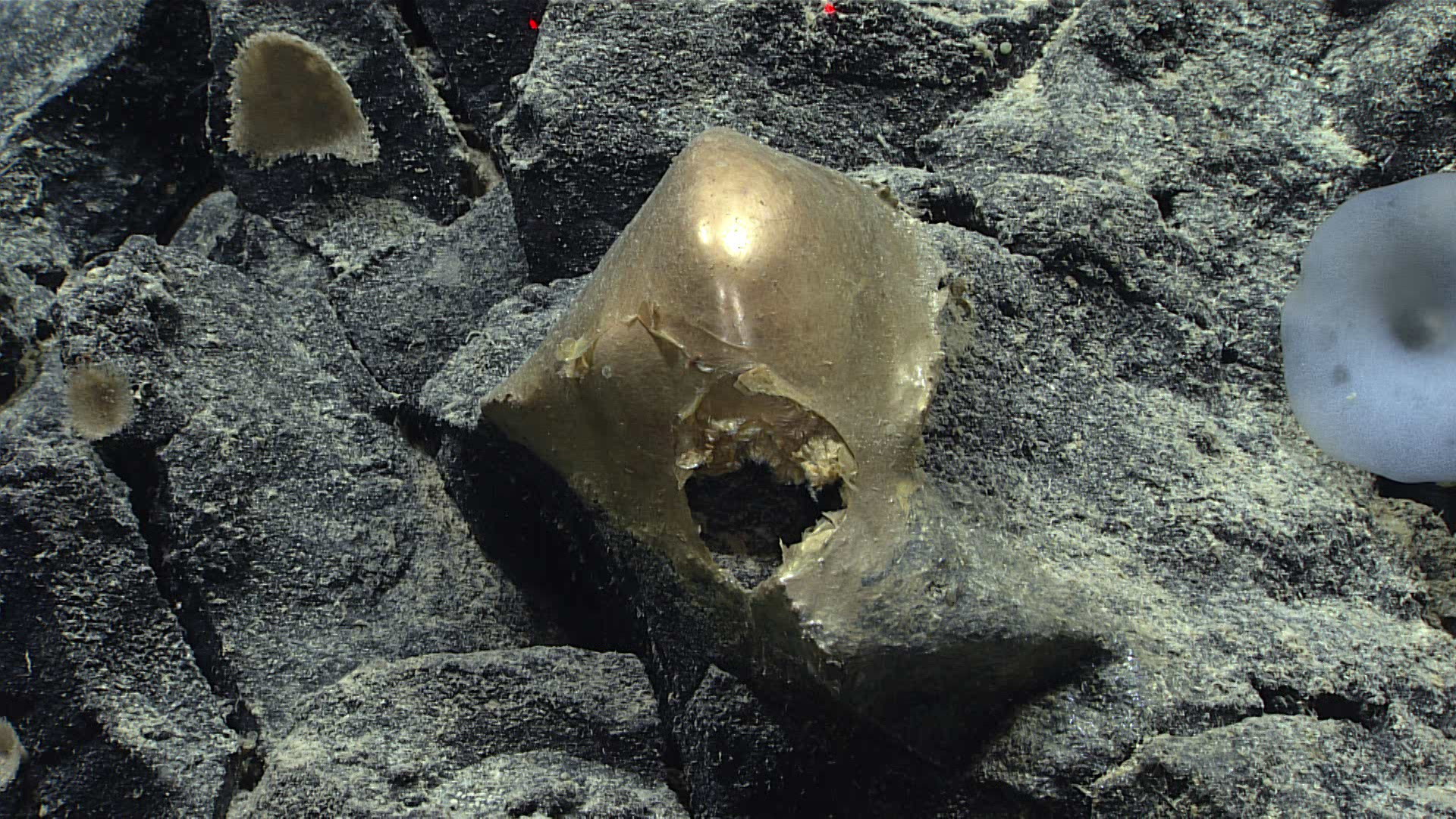
This unidentified specimen, seen in situ on a rocky outcropping at a depth of about 3,300 meters (2 miles), was seen on August 30, 2023, during Dive 07 of the Seascape Alaska 5: Gulf of Alaska Remotely Operated Vehicle Exploration and Mapping expedition.
Image courtesy of NOAA Ocean Exploration, Seascape Alaska.
Download larger version (jpg, 1.3 MB).
Image courtesy of NOAA Ocean Exploration, Seascape Alaska.
Download larger version (jpg, 1.3 MB).
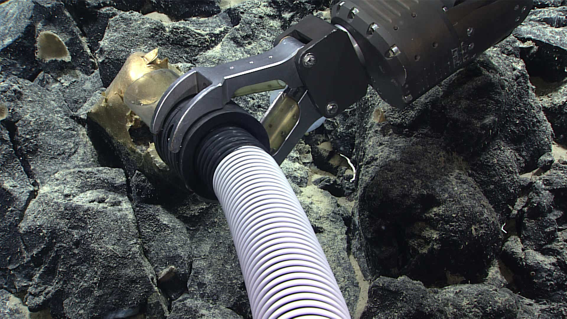
This unidentified specimen, seen on Dive 07 of the Seascape Alaska 5: Gulf of Alaska Remotely Operated Vehicle Exploration and Mapping expedition, was collected using a suction sampler on remotely operated vehicle Deep Discoverer.
Image courtesy of NOAA Ocean Exploration, Seascape Alaska.
Download largest version (1.3 MB).
Download largest version (1.3 MB).
On August 30, 2023, while using remotely operated vehicles to dive on a small seamount in the Gulf of Alaska, mission personnel aboard NOAA Ship Okeanos Explorer came across a confounding sight.
While gliding over a rocky outcrop at a depth of about 3,300 meters (2 miles), they found what one of the videographers onboard helping to document the dive first referred to as a “yellow hat.”
Amid a smattering of white sponges, this smooth, gold, dome-shaped specimen, a little over 10 centimeters (4 inches) in diameter, was tightly adhered to a rock.
A small hole or tear near its base revealed a similarly colored interior.
As cameras zoomed in, scientists were stumped as to its identification, with initial thoughts ranging from a dead sponge attachment, to coral, to an egg casing.
While the find perplexed and inspired an air of creative imagination in many watching the dive live, it has also captured public imagination, inspiring a host of news articles across the country and beyond.
Invoking almost fairytale-like imagery, the specimen has since been dubbed a “golden orb” and even a “golden egg,” by media outlets.
'I don't know what to make of that': mysterious golden orb found on Alaskan ocean floor
"Isn’t the deep sea so delightfully strange?” said NOAA Ocean Exploration’s Sam Candio, expedition coordinator for the ongoing Seascape Alaska 5: Gulf of Alaska Remotely Operated Vehicle Exploration and Mapping expedition that the still-unidentified specimen was found on.
He elaborated, “While we were able to collect the 'golden orb' and bring it onto the ship, we still are not able to identify it beyond the fact that it is biological in origin.
We likely won't learn more until we are able to get it into a laboratory setting where we can continue to pull from the collective expertise of the scientific community with more sophisticated tools than we are able to maintain on the ship.
While somewhat humbling to be stumped by this finding, it serves as a reminder of how little we know about our own planet and how much is left to learn and appreciate about our ocean.”
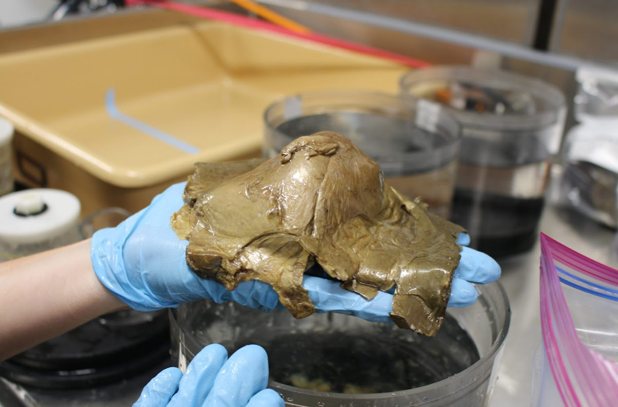
This unidentified specimen, photographed in the wet lab on NOAA Ship Okeanos Explorer, was seen and collected on August 30, 2023, during Dive 07 of the Seascape Alaska 5: Gulf of Alaska Remotely Operated Vehicle Exploration and Mapping expedition.
Image courtesy of NOAA Ocean Exploration, Seascape Alaska.
Image courtesy of NOAA Ocean Exploration, Seascape Alaska.
While it's still unclear if the golden dome is associated with a known species, a new species, or perhaps represents an unknown life stage of an existing one, Sam elaborated on the importance of ocean exploration.
“New species have the potential to reveal new sources for medical therapies and vaccines, food, energy, and other societal benefits and knowledge.
Collectively, the data and information gathered during this expedition will help us close gaps in our understanding of this part of the planet, so we can better manage and protect it.”
The Seascape Alaska 5: Gulf of Alaska Remotely Operated Vehicle Exploration and Mapping expedition continues through September 16, 2023, with livestreamed remotely operated vehicle dives happening daily
Anyone can join live at https://oceanexplorer.noaa.gov/livestreams/welcome.html
Links :
Sunday, September 10, 2023
It's clear: this squid is awesome
Amazing footage of a glass squid, Taonius borealis, seen at a depth of 700 meters (2,300 feet) during the first dive of the Seascape Alaska 3 expedition.
The red organ in the center of the squid is its digestive gland, flanked on either side by two white, crescent-shaped organs that are the squid’s gills.
Also visible below each eye are photophores, which are light-producing organs.
The eye movements shown in the video are thought to be the squid blinking.
This is a fairly common squid in these waters, but the close-up imagery captured here was anything but!
Subscribe to:
Posts (Atom)