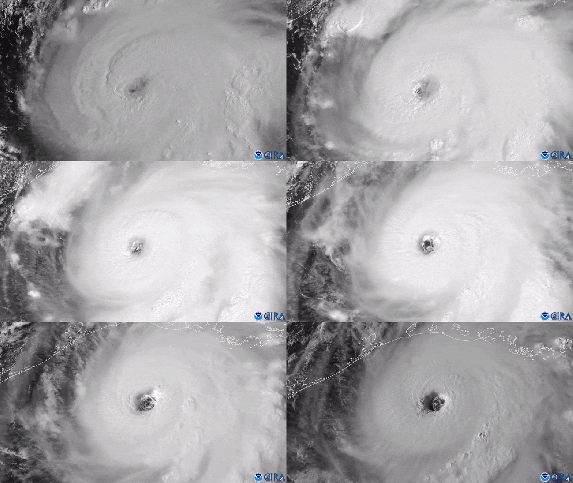
Hurricane Laura underwent rapid intensification over the Gulf of Mexico before it struck Louisiana as a devastating Category 4 storm on August 27, 2020.
Its maximum sustained winds jumped in strength by 63 miles per hour over the previous day.
It was the strongest tropical cyclone to hit the state since Hurricane Camille in 1969.
Its maximum sustained winds jumped in strength by 63 miles per hour over the previous day.
It was the strongest tropical cyclone to hit the state since Hurricane Camille in 1969.
Credit: CIRA/CSU & NOAA
From Scientific American by by Martin J. Kernan
Hurricane forecasters are debuting a new model they hope will better predict when some storms will suddenly and explosively intensify.
Virginia Key sits on Florida’s doorstep, just southeast of downtown Miami, and is firmly in the strike zone of Hurricane Alley—a swath of warm water that is perfect for hurricane formation and stretches eastward across the Atlantic to Africa.
More than 250 hurricanes have hit the U.S. mainland since the mid-19th century, often with catastrophic results.
Virginia Key is also home to the National Oceanic and Atmospheric Administration’s Oceanographic & Meteorological Laboratory, where scientists are hard at work to constantly improve hurricane forecasts.
One of their most pernicious longtime problems is the difficulty of predicting when a relatively minor-seeming storm will suddenly explode in strength and severity—a phenomenon that often takes those in harm’s way by surprise.
“We go to bed, and we see that a storm looks very ragged on the satellite.
And yet we wake up the next morning, and all of a sudden, it’s intensified,” says hurricane researcher Sharanya Majumdar of the University of Miami’s Rosenstiel School of Marine, Atmospheric, and Earth Science, also located on Virginia Key.
“So we all ask, ‘Why did that happen?’”
The answer isn’t always clear, which makes rapid intensification (which meteorologists define as a hurricane’s maximum sustained wind speeds spiking by 35 miles per hour or more over 24 hours) exceedingly difficult to predict.
Accurately predicting a hurricane’s intensity is particularly important, however, because storm force multiplies exponentially with wind speed.
When wind speed doubles, the force exerted on homes, power lines and other infrastructure quadruples.
And studies suggest that more storms will undergo rapid intensification—and do so at faster rates—as the climate warms.
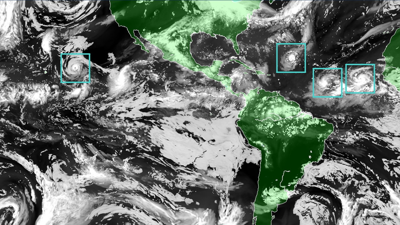
The Hurricane Analysis and Forecast System (HAFS) “moving nest" Model.
Global map showcasing land mass in green and water in black, clouds in white and tropical storms outlined in a green boxes representing the moving nest model.
(Image credit: NOAA)
Now, equipped with a new model that took more than three years to develop, NOAA scientists think they will not only be able to provide earlier warnings of rapid intensification but also better predictions of impacts such as rainfall and storm surge.
Forecasters at the National Hurricane Center will begin using the new model, called the Hurricane Analysis and Forecast System (HAFS), this summer.
“We can’t improve the forecast fast enough, in my mind, to overcome the quadrupling of people living in [coastal] areas in a 15-year period,” says Frank Marks, director of hurricane research at NOAA’s Atlantic Oceanographic and Meteorological Laboratory.
One of the most sobering cases of rapid storm intensification was Hurricane Charley in 2004.
Warnings went up along Florida’s southwestern coast well in advance of the storm.
For about 24 hours before Charley hit, it was forecast to strengthen from a Category 2 to a Category 3 storm.
But in just five hours on August 13—and less than six hours before landfall—the storm’s winds shot up by 34 mph.
By the time it struck Captiva Island in Florida, it had 150-mph winds, just a few miles per hour shy of Category 5 status.
It was the strongest storm to hit Florida since Category 5 Hurricane Andrew decimated the city of Homestead in 1992.
Charley caused more than $15 billion in property damage, and only its small size and relatively fast forward speed kept it from being far more destructive.
“Any time a storm undergoes intensification close to land—but especially if that intensification is underforecast or not forecast at all—the public is at much greater risk because they will be underprepared,” says hurricane researcher and modeling expert Kristen Corbosiero of the University at Albany.
“Thus, the potential loss of life and damage to infrastructure will increase substantially.”
Certain key factors determine whether a tropical cyclone (the broad term for a tropical storm or hurricane) forms, how strong it can get and how quickly it ramps up.
The engine that powers every tropic cyclone is convection: enormous volumes of moist, rising air create a vacuum at the surface that sucks in surrounding air as spiraling winds.
This convection is fueled by warm ocean waters and high humidity, whereas dry air cools a storm through evaporation and impedes convection.
Calm skies must also prevail because crosscutting winds called shear can rip holes in a nascent hurricane’s vortex.
So getting information about a storm’s environmental conditions “is very important—but it’s not sufficient to say for certain if rapid intensification can occur or not,” says John Kaplan, a NOAA research meteorologist.
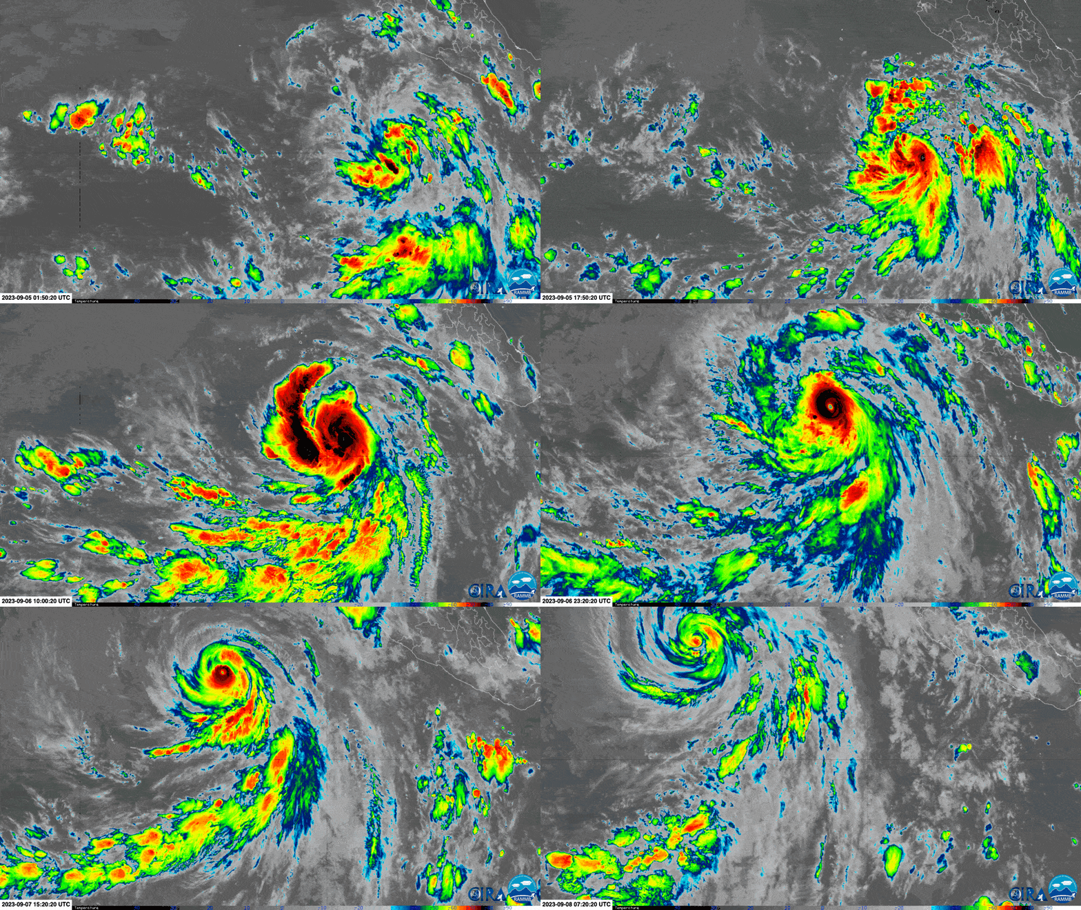
Credit: CSU/CIRA & NOAA
A storm’s internal physics are also crucial to the process.
For example, if the thunderstorms around its center are very symmetric, the pressure “drops like a rock,” Marks says—and the lower the center’s pressure, the higher the winds swirling around it.
Corbosiero, who is not involved in the HAFS work, explains that such symmetry keeps the heat released by developing clouds trapped in the eye wall of the storm.
This, in turn, fuels more convection.
The cylindrical eye wall of the hurricane must also remain straight up and down, not tilted.
If it tilts, the heating spreads over a larger area, and the pressure drop isn’t as dramatic, Corbosiero says.
Limitations in capturing these internal processes with models meant that as recently as the early 2010s, forecasts predicted only 12 percent of rapidly intensifying tropical storms.
Over the following decade, scientists were able to use extra funding from Congress to dispatch drones and crewed “hurricane hunter” aircraft to gather more data on wind speeds, humidity and temperature directly from storms’ eye walls.
This more detailed data let computer models more accurately depict—and therefore predict—storm behavior, helping meteorologists improve their forecasts.
Current models accurately predict rapid intensification 32 percent of the time, according to Mark DeMaria, a former NOAA hurricane forecaster and now a senior research scientist at Colorado State University.
“The inherent predictability of rapid intensification may be low,” DeMaria says, because small, unobservable changes in how a vortex develops may have an outsize impact on when the phenomenon occurs.
Equipped with HAFS, forecasters hope to improve their record by catching at least half of rapidly intensifying storms.
HAFS provides more detailed representations of a storm’s internal dynamics and more data to work with, and it can also incorporate those data faster than current models do—meaning forecasts can be updated more often.
Another key innovation involves “nesting” the HAFS model inside the larger Global Forecast System (GFS) model, where HAFS scans the ocean like a magnifying glass at higher resolution than previous hurricane models.
This nesting lets forecasters tackle another major challenge: reckoning how large-scale atmospheric features, such as cold fronts and high-pressure zones, influence a hurricane’s internal physics.
“A cold front somewhere in a different region of the globe might influence the track and intensity of a hurricane,” says NOAA senior meteorologist and chief HAFS architect Sundararaman “Gopal” Gopalakrishnan.
HAFS becomes officially operational on July 1, which means that forecasters at the National Hurricane Center may rely on it for guidance, along with other models, in making their predictions this summer.
Gopalakrishnan says he is excited to see how HAFS performs and expects it to do a much better job than the model it’s replacing.
“We’re going to be watching it like a hawk,” Marks says.
Links :
- Wired : The Rapid Intensification of Hurricane Lee Is a Warning
- Scientific American : How Hurricanes Jova and Lee Rapidly Exploded into Category 5 Storms
- NOAA : NOAA launches new hurricane forecast model as Atlantic season starts strong
- Nature : For essential weather predictions, look to the cloud
- GeoGarage blog : NOAA launches new hurricane forecast model


No comments:
Post a Comment