Saturday, September 11, 2021

Image of the week :largest island in the North Sea bay of Kattegat, Denmark

Amazing layers of turbid waters surrounding and moving around the island which is the largest in the North Sea bay of Kattegat, northern Denmark Læsø ("Isle of Hlér") 
@CopernicusEU Sentinel2  2021-08-30
 
courtesy of Iban Amestoy
 
Læsø island with the GeoGarage platform

Friday, September 10, 2021

Arctic’s ‘last ice area’ may be less resistant to global warming

 
The German research icebreaker Polarstern heading toward the North Pole through thin ice last August.

From NYTimes by Henri Fountain

The region, which could provide a last refuge for polar bears and other Arctic wildlife that depends on ice, is not as stable as previously thought, according to a new study.

Last August, scientists aboard an icebreaker that had been drifting with the ice across the Arctic Ocean in a yearlong research expedition decided to take a detour to the North Pole.

They needed to get there quickly, so they used satellite data to find a route where the concentration of sea ice was low enough for the icebreaker, the Polarstern, to push through easily.
They found it in an unlikely place, the Wandel Sea, just north of Greenland.

“This area used to be one that was chock-full of this old, thick sea ice,” said Melinda Webster, a researcher at the University of Alaska Fairbanks who was on board for this part of the Mosaic expedition. 
“It’s not what we encountered when we went through there.”
 
Instead, the ice was thin and there was plenty of open water, Dr. Webster said.

Scientists have now shown why ice conditions in the Wandel Sea were vastly different last summer.
The warming Arctic climate thinned the ice, they say, and an unusual shift in winds pushed much of it out of the sea.
 

“As it is typically with extreme events, there’s an underlying climate change component,” said Axel J. Schweiger, a climate scientist at the University of Washington and the lead author of a paper describing the research published Thursday in the journal Communications Earth & Environment.

The findings have potentially troubling implications for the Wandel Sea and nearby waters north of Canada, a region often referred to as the “last ice area.”
Because a circular ocean current, the Beaufort Gyre, tends to keep ice trapped there, climate models have predicted that it will likely retain ice as warming causes the rest of the Arctic Ocean to become ice-free in summers, perhaps in the next few decades.

If this region does remain full of ice, it may provide a last summer refuge for polar bears and other Arctic wildlife that is dependent on sea ice.
But the new research suggests the area may be less resilient to warming, and that similar periods of low ice concentrations are to be expected.

“This region is not as stable as we used to think,” said Luisa von Albedyll, an ice-dynamics researcher with the Alfred Wegener Institute in Germany, who also was aboard the Polarstern when the route was chosen. Neither she nor Dr. Webster was involved in the new research.

Dr. Schweiger and other researchers had seen and studied thinning ice in the Wandel Sea in recent years, including a time in 2018 when a large area of open water, called a polynya, had opened.
The experience of the Polarstern also piqued Dr. Schweiger’s interest.
The route “normally wouldn’t be the first choice for an icebreaker captain,” he said.
 

Using satellite images and computer models that simulated sea ice, he and his colleagues showed that most of the effect on the ice in the Wandel in 2020 could be linked to natural variability in the winds in the area.

Those winds normally blow from the north and, with the Greenland and Canadian coasts to the south, tend to keep the ice in place.
 
In August 2020 they shifted so they were blowing in the opposite direction, causing much of the ice to leave the sea and drift elsewhere.
 

But the simulations also showed that climate change played a role by melting and thinning the ice, as it has elsewhere in the Arctic Ocean in recent decades.
While the world overall is warming as a result of human-caused emissions of carbon dioxide and other heat-trapping gases, the Arctic is warming about two and a half times faster than average, much faster than other regions.

The researchers also looked at what might have occurred in previous years under the same wind conditions that existed last summer, using data beginning in 1979, when modern satellite imagery of the Arctic began.

The analysis showed that if the same shifting winds had occurred in 2018 and 2019, similar low-ice conditions would have resulted.
“But the likelihood that this would have happened with ice from 1979 is a lot smaller,” Dr. Schweiger said, because the region had not warmed as much at that point and the ice was thicker.

Dr. Webster said the study provided a “very reasonable explanation” for what occurred last summer. And it illustrated an important point about the effects of climate change in the Arctic, she said.

“As sea ice thins and as it becomes more seasonal, it becomes more sensitive to what’s happening in the atmosphere and ocean,” she said. 
“So windy conditions will play a larger role.”

“What we experienced last summer was unprecedented,” Dr. Webster added.

Thursday, September 9, 2021

This barnacle-inspired glue seals bleeding organs in seconds

 
If you want to solve a problem, you can probably find an animal that’s already evolved to solve it.
Photograph: Paul Maguire/Getty Images
 
From Wired by  Max G. Levy
 
EXCESSIVE BLEEDING IS, in some sense, an engineering problem.
 
“For us, everything is a machine, even a human body,” says Hyunwoo Yuk, a research scientist in mechanical engineering at MIT.
“They are malfunctioning and breaking, and we have some mechanical way to solve it.”

About 1.9 million people die every year from blood loss, sometimes from trauma, sometimes on the operating table.
Bleeding bodies are wet, prone to infection, and need urgent care.
Yet it’s hard to create a seal on wet tissue, and most commercial products used to stop dangerous bleeding rely on coagulants which take minutes to work.
Some people don’t have minutes.

For the last seven years, Yuk’s team has been developing an entirely different approach to stopping bleeding: glue.
More specifically, glue inspired by barnacles.
Yuk says barnacles hold an evolutionary solution to the problem of sticking to surfaces that are resistant to getting stuck.
In a study published this month in Nature Biomedical Engineering, his team demonstrated how this arthropod-like glue can stop bleeding in seconds.

In the experiment, Yuk treated rats with bleeding heart and liver injuries with products typically used by surgeons.
No dice—the bleeding continued.
On others, he squeezed on the lab’s oily paste.
“Exactly the same injury could be sealed in just 10 seconds or so,” he says.

The rats survived thanks to the glue, and so did pigs that were tested by Yuk’s collaborators at the Mayo Clinic.
Their evidence, although still preliminary, bodes particularly well for human surgical patients with blood, heart, and liver disorders.
“My overall impression of this material is that it's incredible,” says Hanjay Wang, a resident in Stanford University’s Cardiothoracic Surgery Department who was not involved in the study.
“It definitely fills a need, especially in the emergency setting, when you need to just get control.”

THE TEAM OF engineers knew they might find inspiration in the animal world.
“The driving force for nature's evolution is survival,” Yuk says.
If you want to solve a problem, you can probably find an animal that’s already evolved to solve it.
Barnacles caught their attention, he says, because they are annoyingly sticky: “It's sticking on rock, sticking on rusted steel, it’s sticking on slimy surfaces like whales and turtles.”

Barnacles cling thanks to a cement of proteins secreted from glands along each animal’s “forehead.” But the secret sauce—well, more of an oil—is a cocktail of lipids that first sweep contaminants away from surfaces so the proteins can do their thing.
“So basically they are terraforming the target substrate,” Yuk says, priming it for a fast, strong seal.

And it turns out that you need a similar superpower when trying to seal up bleeding animal tissue.
In a way, says Yuk, blood is a “contaminated fluid” because it’s not a homogeneous liquid—it’s filled with blood cells.
For an adhesive to work, you’ve got to shove those cells out of the way.

Instead of using actual barnacle proteins for their test glue, Yuk’s team referred to it as a kind of chemical rubric for devising a high-pressure physical barrier.
In place of sticky protein particles, they repurposed a previous lab invention: biocompatible adhesive sheets made from a cocktail of organic molecules, water, and chitosan—a sugar found in hard shellfish exoskeletons.
(Barnacles use a similar compound called chitin, and chitosan is already used widely in wound dressings.)
Then they tossed the sheets into a cryogenic grinder that pulverized them until they turned into shards roughly one hundredth of a millimeter across.

As the blood-repelling agent, they used silicone oil, which is already used in medicine as an inert lubricant for surgical tools, and as a substitute for vitreous fluid after retinal detachments.
The microparticles and oil mixed to create a glue with the look and feel of a cloudy white toothpaste.

 
Barnacles use similar contaminant-repelling oils in order to stick to ships and whales. 
Photograph: Hyunwoo Yuk
 
The paste passed through a gauntlet of mechanical tests to record how tightly—and quickly—it could seal issue samples.
Yuk squeezed the paste from a syringe onto a sliver of pig heart, then pressed a tiny metal spatula against it.
Under that pressure, the silicon oil cleared away debris and fluid.
At the same time, the mass of sticky microparticles congealed with the edges of proteins jutting from the tissue’s surface.
A strong bond formed within seconds.

Yuk then compared the barnacle glue to products used by surgeons, sealant pastes like Surgiflo and a coagulation patch called TachoSil.
In comparison, the barnacle glue formed a bond that was eight times tougher.
And when tested on an isolated pig aorta for its “burst pressure”—the limit before a seal ruptures—Yuk’s glue held firm at up to twice the expected pressure from blood flow.

Encouraged, the team was ready to test their invention on live animals.
Anesthetized rats bleeding from 2-millimeter knicks in their heart chamber muscles received either the barnacle glue or one of two commercial alternatives: Surgicel and CoSeal.
But only the glue overcame the pressure produced by the beating heart to form a seal—the bleeding stopped in seconds.
(You can see the video here, but be warned, it’s graphic.) 
“It was very visually shocking,” Yuk says.

The team repeated similar tests on rats’ livers, an important region for bleeding studies, since it’s the body’s most vascularized organ.
Again, the glue stopped the bleeding in seconds.
And two weeks later, the holes in the hearts and livers remained sealed up tight.
“That rat could wake up and recover.
We could cuddle her while we were in the husbandry room,” Yuk says.

 
The barnacle-inspired glue is made from a mixture of sticky microparticles and silicone oil, which repels blood away from tissue.
Photograph: Hyunwoo Yuk

Then came the pigs.
Yuk looped in a team at the Mayo Clinic that was better equipped to operate on large animals.
The team wanted to avoid relying on the blood’s natural coagulation ability, since many people undergoing surgery have clotting issues themselves.
So, before any experiments, the three test pigs received heparin, a blood thinner.
The researchers cut three holes, 1 centimeter wide and 1 centimeter deep, in each of the animals’ livers, then treated the nine injuries with either the paste or a TachoSil patch.

Tiffany Sarrafian, one of the team’s veterinary surgeons, says she’s never seen anything work like this glue.
“We just put the paste on, and we're counting” for a few seconds, Sarrafian says, recalling the procedure.
“You take your hand off and you're like, ‘Hang on, there's no blood!’ It was pretty amazing.”

Sarrafian had planned that if the comparison commercial patch didn’t work after three minutes, she would reverse the anticoagulant in order to keep the pigs alive, and then allow them to clot and heal naturally.
But she added another step to stop the bleeding faster: plopping on a pea-sized squeeze of the experimental glue.
“It kind of is miraculous, in a way,” she says.

To be fair, coagulant patches like TachoSil aren't designed to stop heavy streams of blood from tissue with unclottable injuries.
But, in medicine, that’s an unmet need, says Christoph Nabzdyk, a cardiac anesthesiologist and critical care physician on the Mayo team.
“With aging populations, you have more and more patients that have either acquired bleeding disorders or are ultimately on blood thinners,” he says.
“The problem of bleeding, and bleeding control is substantial.”

He and Saraffian add that having an inexpensive glue that stops major bleeding andgoes on already-wet surfaces would be potentially lifesaving for patients, and it would be particularly useful in places without a lot of surgical resources, like in wilderness areas, combat zones, or less developed countries.

“Nothing in the material there is totally new, but this concept is really cool and unconventional,” says Shrike Zhang, a biomedical engineer who leads a lab at Harvard Medical School.
While materials like silicone oil and the adhesive ingredients are commonplace, their combination makes for something exciting.
”It's pretty early, but the animal data are pretty strong,” he continues.

But, says Wang, the Stanford cardiothoracic surgery resident, there are still elements that need to be optimized before the adhesive could be used in humans.
A glob of glue that seals damaged tissue in an emergency, or sticks to surrounding healthy tissue, could complicate any surgeries that follow.
“The question is, will you be able to operate in that area?” he asks.

Yuk’s team devised a solution to reverse this type of adhesive seal, and preliminary results in rats are promising.

They also want to know how long that seal lasts; ideally, it should not dissolve until after the tissue has healed on its own, but it also shouldn’t last forever.
The new study shows that the paste dissolves noticeably within 12 weeks, based on microscope images in a separate experiment using rats.
Depending on the injury and healing response, that may be plenty.

Another challenge is that other types of sealants are known to kill tissue over time.
Wang—and Yuk—note that a long-term study will be essential.
So far, their longest observation on bleeding organs is about one month after the glue’s application, using the pigs from the Mayo Clinic test.

And while it may still be many years before a sealant paste replaces the trusty suture, both surgeons and mechanical engineers would welcome the ability to glue patients back together quickly, to make bodies once again run like well-oiled machines.

Wednesday, September 8, 2021

The South China Sea reveals China’s grand strategy

 
From National Interest by Akshobh Giridharadas 

To understand China’s grand strategy, particularly Xi’s long-term game, one needs to understand Beijing’s belligerence in the South China Sea.

Fire and water are juxtaposed in the phraseology of elements, but Robert Kaplan’s book Asia's Cauldron: The South China Sea and the End of a Stable Pacific alludes to how a large water body is now a simmering cauldron.
If modern-day geopolitical advantages are said to be shaped by three things, trade, natural resources, and supply chains, then all those three aspects are epitomized by who controls the South China Sea.

In terms of natural resources, the South China Sea has 11 billion barrels of oil, around 190 trillion feet of natural gas, 40 percent of global liquified natural gas (LNG), and 12 percent of the world’s fisheries, caught by 50 percent of all the fishing vessels globally.
When it comes to trade, 30 percent of the world’s shipping trade flows through these waterways; that is around between $3-5 trillion worth of trade—or somewhere between the economies of India and Japan.
Anything with the “Made in China” tag likely flows through this region.

This region services a market of 2.2 billion people, China’s 1.5 billion and around 650 million people in the region that the Association of Southeast Asian Nations (ASEAN) calls home.
That itself is one-quarter of global humanity in just a single region.

The Militarization of the South China Sea


Fiery Cross Reef is one square mile in size and home to a military base with a 10,000-foot airstrip and a missile defense system, radar system, and about 200 troops.
It’s not the fifteenth century, so China hasn’t just innocuously planted its flags and posted a watchtower there.
Satellite images show that Fiery Cross Reef was established in 2016, but, strangely enough, it was just rocks and gravel two years before that; the base didn’t exist in 2014.
This isn’t the only one either: there are five other military bases in the South China Sea—Cuarteron Reef, Mischief Reef, Subi Reef, Gaven Reef, Hughes Reef.

In 2014, satellite images showed that Chinese naval ships were collecting rock and gravel and consolidating various archipelagos in the South China Sea, building islands.
And from this, they had seaports, naval bases, and islands.
China says its outposts are not militaristic, but its actions say otherwise.

The Elephant in the Room is the Dragon

China’s grand strategy is having a vantage point and key assets in both the Pacific Ocean and the Indian Ocean, and the South China Sea is that crucial nexus in between.
Presently, five countries in the ASEAN region lay claim to the South China Sea: Malaysia, Indonesia, Vietnam, Philippines, and Brunei.
Taiwan also has its own claims.

As it stands, the United Nations Convention on Law of the Seas (UNCLOS) which first came about in 1973 (replacing Freedom of the Seas) was signed by over 150 countries, including China.
It clearly states that a country’s territorial waters are within 12 nautical miles of its coast.
Interestingly, the more important clause, particularly pertinent to the kerfuffle in the South China Sea, is that countries have an exclusive economic zone (EEZ) up to 200 natural miles off their shore.
This includes free passage, access to all natural resources including, energy, fisheries, and, of course, trade routes.
Any area that is outside the EEZ is deemed as international waters.

As China’s position on the world stage grew, so did its presence in the South China Sea.
Even though China is a signatory to UNCLOS, it cleverly skirts around the issue of being a signatory by using the nine-dash line.

According to Kaplan, “The origins of the nine-dash line can be traced back to the official maps made by the Nationalist Kuomintang (also known as the Chinese Nationalist Party) government before and after World War II.” But some reports suggest that China has referenced fifteenth-century naval expedition maps and even asked cartographers in 1929 to demarcate the territory along the nine-dash line.
If the partition of the subcontinent has taught us anything, drawing lines on the map can never end well.
Les footballeurs français et leurs femmesMarie France

With this nine-dash line, China is able to claim 1,800 km (or 1,100 miles) of territory, which is 90 percent of the waters.
China’s claims emerged for those islands from 1907 to 1947, even as China’s internal turbulence saw the nationalists and communists dueling for supremacy, the world was being singed with both World Wars, and Imperial Japan was brutally laying its own claim to the region.
Accuracy aside, from Beijing’s perspective, in some ways, there has always been a consistency to China’s claims, which even predates the founding of the United Nations and ergo predates UNCLOS.

From the turn of the twentieth century, there was always a colonial presence: Britain in the Malaya Peninsula (Malaysia and Singapore), the Dutch in Indonesia, France in Indochina (Vietnam), and Japan during its occupation during World War II.
It became an emotional question for Beijing, where China wanted to stand up to the world and reclaim its civilizational glory, secure its fragile land and maritime borders, and assert its sovereignty in the South China Sea.
But the turbulence increased further in between the 1960-70s when oil was discovered, increasing the region’s allure.

China’s claims have now taken on a life of their own.
For China is not just claiming all the water, but the islands, the seabed, the resources in it, and the airspace above it too.
And in 2013, Beijing added a tenth line—to include Taiwan.
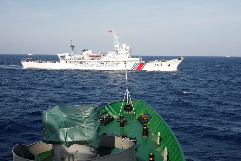
Beijing’s Belligerence

The Spratly Islands are clustered in the heart of the South China Sea, and China wants to claim them to extend its EEZ all the way to the borders of Vietnam and the Philippines.
This has now in the geopolitical lexicon come to be codified as the “cabbage strategy” (surrounding contested islands with as many ships as possible).
In May 2013, China sent ships to Ayungin Shoal, and like wrapping leaves around a cabbage, surrounded the island.
This created a blockade and precluded the Philippines from receiving food and other essential supplies.
This struggle of surrounding islands with ships and building military bases is closer to the concept of Salami slicing—where China takes a series of smaller provocations beneath the threshold of war to attain a much larger strategic objective.
But Beijing’s bellicosity doesn’t end there; In 2015, China declared anything above the South China Sea was now part of its air identification zone.
No wonder that Steve Bannon, a hawkish former adviser to President Donald Trump, once said that a war in the South China Sea would be inevitable.

Enter America

The militarization of the South China Sea is tempestuous, but it wouldn’t be a geopolitical conflict without U.S.
involvement.
While the United States lays no claim to the South China Sea, the region is central to Washington’s Pacific Command and Pacific fleet.
Washington frequently sends its foremost naval assets like the USS Ronald Reagan into the waters.
U.S.
destroyers have come close to Subi Reef, irking Beijing, which sent out its own destroyer ship in response.
The United States is committed to enforcing the idea of the Freedom of the Seas, and it sees this sacrosanct philosophy in peril in the South China Sea due to Chinese actions.

The Quadrilateral Security Dialogue (Quad), a strategic partnership between Japan, the United States, Australia, and India, has become a bulwark against Chinese aggression in the region.
While it is not accurately described as an “Asian NATO,” it is clearly a pact with a focus on mutual security.

In the final days of its term, the Trump administration released a slew of measures against China, particularly with sanctions the over South China sea.
Former Secretary of State Mike Pompeoturned up the heat on China when he said to ASEAN “Don’t let the Chinese communist parties walk all over us.” Pompeo added that the South China Sea is not China’s maritime empire and that Beijing “does not respect fundamental democratic values as those enshrined in the ASEAN charter.”

The Chinese navy’s expansion has become a concern for the United States and ASEAN nations.
The Department of Defense has stated that China may be the first to attach anti-ship ballistic missiles, colloquially known as “carrier killers” in the South China Sea.
Beijing has alluded to Barack Obama’s pivot to Asia as a clever ruse to lure the ASEAN member nations to turn against China—what Beijing sees as turning “friends” into foes.
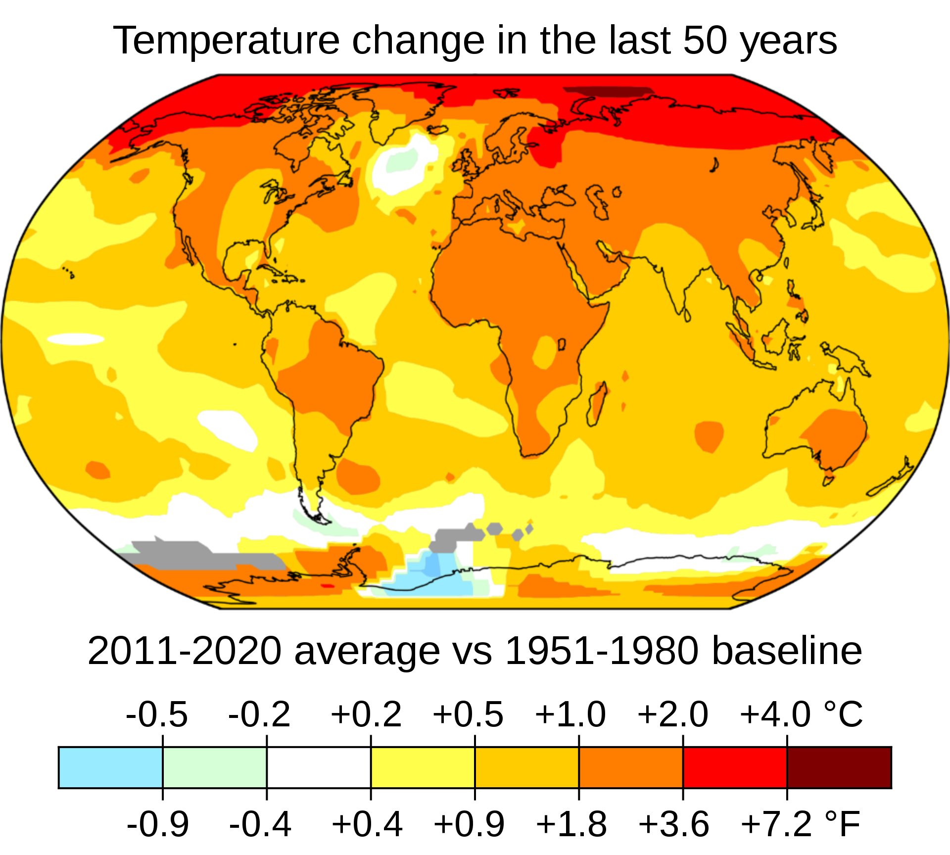
How 2008 Changed the World

The year 2008 was seminal for two reasons.
One, of course, was the impending collapse of the financial system, because as America sneezed, the rest of the world caught the cold.

Second, the Beijing Olympics was a grand spectacle, not just for Michael Phelps’ aquatic prowess or Usain Bolt’s Cheetahesque pace, but it was China’s announcement to the world that Beijing was ready to dictate the twenty-first century’s economic growth.

After Xi Jinping arrived on the scene in 2012, there have been fundamental differences in how China approaches its foreign policy and economic objectives.
From Deng Xiaoping to Xi Jinping, China moved from a “peaceful china rise” behind the scenes into adopting a new sense of bellicosity, one where its diplomats embrace a wolf-warrior style assertive diplomacy.

Beijing’s general military philosophy is called active defense, perhaps closer to salami slicing, where China engages in the minimum provocative measures to raise a counterstrike from its adversaries, thus presenting Beijing with opportunities to strike back with a further vengeance.

Since Xi arrived, China’s coast guard, navy, and People’s Liberation Army have all adopted a sense of active defense.
According to one such report, a disgruntled Chinese voice shouted over the radio as a Philippine military plane flew in the South China Sea, "Philippine military aircraft, I'm warning you again: leave immediately or you will bear responsibility for all the consequences.
How long this competition remains mired in harsh rhetoric and legal battles before missiles start flying is anyone’s guess.

The South China Sea’s Future

So how do these tempestuous waters turn tranquil? Broadly speaking there are three likely scenarios as it stands.

First, there is what Beijing wants: where the ASEAN countries kowtow to China and understand the asymmetry of power and the importance of China’s economic needs.
Much like Game of Thrones’ Lannisters, the implication is that China will not forget to pay its debts and will recompense the ASEAN countries through some form of trickle-down economics by way of investments—Beijing’s infamous debt trap diplomacy—or be their naval guardians, dislodging decades of Washington’s regional security presence.

Second, there is a scenario where China reaches a compromise between itself and the South China Sea’s other claimants.
What that compromise looks like is as murky as the waters, partial pun intended.

Third, there is the scenario that everyone wants to avoid: the outbreak of regionwide warfare.
While today it appears unlikely that tensions will spill over, neither China, it’s neighbors, nor the United States are backing down from their positions, which may only harden further with time.

There is also a fourth scenario, but that is least likely to happen.
In this situation, China says walks away from its claims, and the other five regional players go back to enjoying the fruits of their own UNCLOS-codified EEZs unmolested by Chinese aggression.

One thing is for certain, however.
To understand China’s grand strategy, particularly Xi’s long-term game, one needs to understand Beijing’s belligerence in the South China Sea.
The region holds vast economic incentives through trade routes, supply chains, and natural resources in oil and fish that China’s Brobdingnagian population needs.
Ever-interested in attaining economic hegemony, China knows it must also get weaker states to acquiesce to its economic plans that offer costly developmental loans in exchange for political or economic concessions in the future—the so-called debt-trap diplomacy.
Then there is China’s military posturing through its bases in the Spratlys and Paracels, which is an extension of China’s ideological need to secure its fragile maritime and land borders after a century of humiliation.
China is pursuing all of these things through its wolf-warrior diplomacy, meeting critiques with corrosive aggressive countering, and not overly concerning itself with international opprobrium.
Xi Jinping has made clear that he will secure what the Chinese Communist Party believes are China’s core interests, at all costs, and the rest of the world had better take note.

Links :

Tuesday, September 7, 2021

Robo-penguin: how artificial birds are relaying the secrets of ocean currents

Researchers hope to use artificial intelligence to allow the robot penguins, named Quadroins, to interact with each other.
Photograph: Hereon/Florian Büttner
 
From The Guardian by Florian Sturm

They can go on research missions in stormy weather, dive to 150 metres and could soon be ‘singing’ signals.
These penguin-like devices are helping to explain the eddies that are key to all life

If it looks like a penguin and swims like a penguin – but it’s actually a robot – then it must be the latest advance in marine sensory equipment.

The Quadroin is an autonomous underwater vehicle (AUV): a 3D-printed self-propelled machine designed to mimic a penguin in order to measure the properties of oceanic eddies.

It was developed by Burkard Baschek while head of Germany’s Institute of Coastal Ocean Dynamics at the Helmholtz Centre Hereon in Geesthacht after he watched more than $20,000 of his equipment sink to the bottom of the Pacific Ocean.

 
A Nasa image of the eddies and small currents just below the ocean’s surface, showing the swirling pattern of phytoplankton blooms in the southern Atlantic Ocean.
Photograph: Nasa/Zuma/ Rex/Shutterstock


Eddies are small ocean currents that other research methods have struggled to capture.
They influence all the animals and plants in the seas as well as the Earth’s climate, driving roughly 50% of all phytoplankton production.
The base of the marine food chain, phytoplankton and other marine plants such as kelp and algal plankton also produce up to 70% of atmospheric oxygen.

“Every fourth breath each human takes depends on those small ocean eddies,” says Baschek, who is now director of the German Oceanographic Museum in the northern port of Stralsund.

Despite their significance, eddies are poorly understood within the scientific community because they are small; some are just 10 metres across, and they have an average lifespan of 12 hours, posing a huge challenge for ocean observations.
Few detailed measurements even exist.

Baschek first developed an array of about 20 sensors attached to a rope, to be towed behind a ship to measure key oceanographic variables in the eddies – such as temperature, salinity, pressure, chlorophyll and oxygen.
But the rope would catch on rocks, fishing nets or containers – sending all the data to the seabed.

“The only way to avoid such underwater hazards was to develop a device which can do these measurements without being tied to a rope,” says Baschek.
 
 
A gentoo penguin.
The birds’ shape provided the optimal model to make the Quadroin as streamlined as possible, the team found. 
Photograph: Xinhua/Rex/Shutterstock

The solution came from Rudolf Bannasch and his team at the Berlin-based company EvoLogics, which specialises in bionics based on natural evolution.
Bannasch knew exactly what Baschek needed: a penguin.
“Penguins provide a shape with optimal streamlining characteristics,” says Bannasch.
His studies in wireless underwater navigation and communication systems suggest that penguins are 20% to 30% more streamlined than anything designed in a laboratory, ideal for the high-speed measurements Baschek sought.

In April, the first Quadroin prototype – the name derives from “quadro”, after the four propellers that move the AUV, and “penguin” – had its maiden voyage in a lake near Berlin.
It has a maximum speed of eight knots (9.2mph) and uses the same sensors that used to be towed on a rope.
The Quadroin, however, can roam freely through the water, avoiding obstructions, to depths of 150 metres.

One element in the study of eddies that has stumped scientists is that they need to be measured in multiple locations simultaneously.
Bannasch and his colleagues are working to create two more artificial penguins that would act as a “swarm”, swimming in unison and communicating with each other.

“We developed the first singing underwater modems so that the Quadroins will able to send and receive chirping signals similar to those of dolphins,” says Bannasch.

 
Burkard Baschek with the artificial penguin he helped develop.
It can dive to 150 metres and avoid obstacles.
Photograph: Hereon/Florian Büttner

Along with other miniature sensors, such as GPS, integrated into the metre-long body, the robo-penguins can relay data to each other as well as in real time to a research ship.
The company aims to use artificial intelligence to allow smart group behaviour and decision-making, so the Quadroins know what measurements mean and what steps to take next.

Though developed to measure quickly evolving oceanic processes, the 25kg (55lb) Quadroins could also be used for surveys in environments where other vehicles are unable to go – for example, under sea ice or in shallow water.
“They can be parked in docking stations and go on regular research missions when storms make it impossible for vessels to leave the port.
In the North Sea, for instance, this is the case almost every second day,” Baschek says.

At about €80,000 (£69,000) apiece, the Quadroins are not cheap, though that is roughly the same as the cost of hiring a fully equipped research vessel for just one day.
Most other high-performance AUVs are also more expensive and less versatile.
The hope is that the Quadroins could make remote marine studies much more accessible to universities, research institutes and oceanographic firms that lack huge budgets.

As for losing them to the bottom of the ocean, the artificial penguins have a final trick that also mimicks their real-life counterparts: if the electronics fail and the sensors go dark, they float.
 
Links :

Monday, September 6, 2021

Lidar helps to illuminate the future of oceans

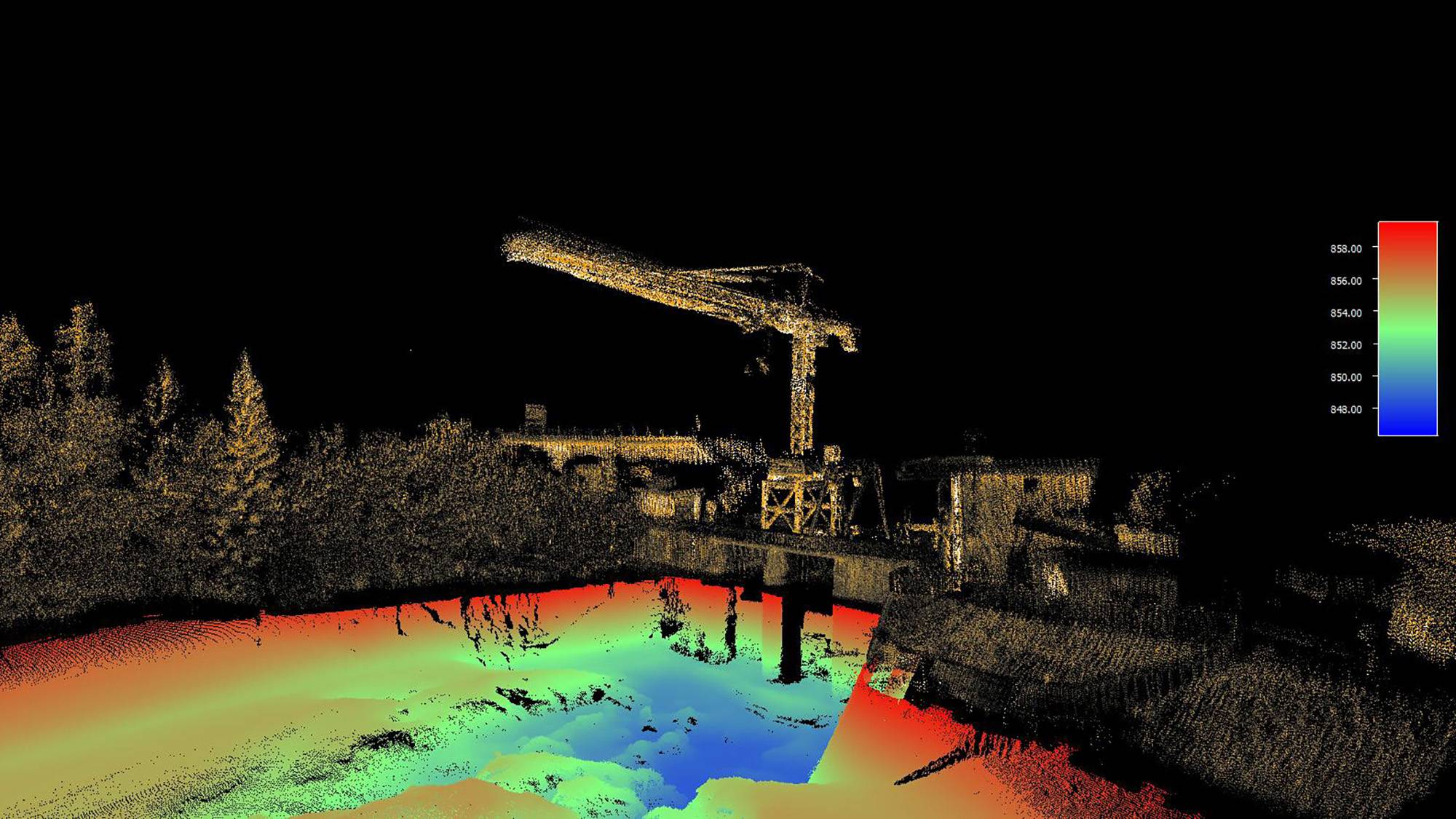
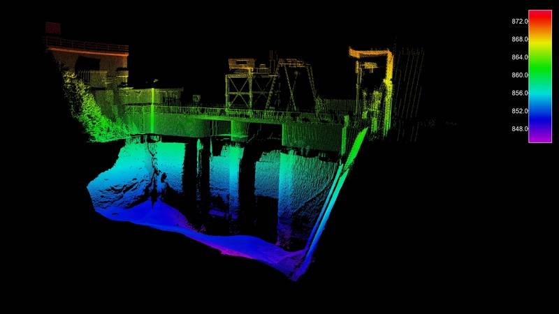
35kg RAMMS ALB sensor offers a unique combination of scanning capability (2ppm density & 3x Secchi penetration), and small form-factor.
© Fugro
 
From MarineTechnology by Celia Konowe
 
The statement that 80% of our world’s oceans remain unexplored is well known—and possibly, overstated.
Observance of United Nations World Oceans Day on June 8 underscored the deter-mination to better understand and protect our waters.
While limitations in the ocean still inhibit the same level of progress that we’ve achieved on Earth’s terrestrial surface, some of the same technology is playing a role in the game of marine catch-up.


Lidar, which stands for “light detection and ranging,” utilizes laser light to measure distances on Earth and produce 3D models of the surveyed area.
The technology is either topographic or bathymetric, employing a near-infrared laser for the former and a water-penetrating green laser for the latter.
Lidar data enables countless applications, including examining natural and manmade environments, transportation routes, and maintenance inspection.
In the marine world, lidar has gained a reputation for increasing our exploratory efforts and, more recently, for examining the coastal ecosystems, communities, and structures that grow increasingly sen-sitive to climate change and intensifying weather patterns.

Lasers: A Shore way to Protect the Coast

Velodyne Lidar, a lidar solutions company based in California, has recently partnered with Sea-bed B.V., a technical solutions group from the Netherlands, to help complete a lidar mobile mapping system.
With the goal of protecting sensitive shorelines through sustainable planning, Velodyne’s contribution is the Puck lidar sensor, which will complement Seabed’s existing map-ping technology.

“Velodyne produces technology to help machines ‘see’—the Puck can be considered the eyes of the application.
It collects real-time, surround view, 3D-distance and calibrated reflectivity measurements to detect potential hazards, even in a wide variety of lighting and environmental conditions, including in the dark, where cameras struggle,” Executive Director Europe Erich Smidt explained.
Velodyne’s Puck sensor will help provide holistic, above-water point cloud da-ta, including specific measurements of inshore, nearshore and inland waterways from up to 100 meters away, and is designed to be mobile and easy to use without specific training, saving both time and money in data collection.

The implications of this work are seemingly limitless.
Aside from conserving sensitive historic and marine environments, Velodyne’s lidar technology can be paired with a bathymetric echo-sounder to provide complete, above- and below-water 3D imaging.
This data can be used to assess bridges, piers, dams and other infrastructure, further helping sustainability planning, as well as navigation safety.
Sustainability, though, may be a growing cause.

 
An artist rendition of Standford’s photoacoustic airborne sonar system operating from a drone to sense and image underwater objects.
© Kindea Labs


Fugro is also tackling the coastline protection head on.
For the first time in the UK (previous ap-plications have occurred in North American and the Caribbean), its Rapid Airborne Multibeam Mapping System (RAMMS) will be used to collect bathymetric lidar data.
Coastal flooding has become a concern due to rising sea levels and intensifying weather patterns and the Depart-ment of Agriculture, Environment and Rural Affairs (DAERA) in Northern Ireland has called for a study of the 763 km coastline.
“A recent report by The Lightsmith Group has highlighted costs of $167 to $357 billion a year by 2030 to tackle climate change in developed countries with an expected $119 billion of global costs annually linked to extreme weather events by 2040,” said Chris Boreland, Fugro’s business development manager for remote sensing and mapping solu-tions.
Unfortunately, this means that human-made and natural environments along coastlines will be at the forefront of climatic impact in the coming decades.DAERA’s hope is to create a baseline survey across Northern Ireland that will identify areas at highest risk of coastal erosion and flooding now and into the future.
The consequent 3D model will be a tool for policymakers and coastal managers alike.
“The issue is that the coastal envi-ronment, particularly the nearshore or ‘white ribbon’ region, is extremely challenging to sur-vey,” Boreland explained.
“Survey vessels can’t get close enough due to the shallow water and wave action, and it’s too dangerous for onsite surveyors to wade out.”

Fugro’s RAMMS sensor can be operated from a small aircraft or unmanned aerial vehicle to capture high-resolution data three times the depth of visual water clarity.
The system pulses rapid beams of light from the sensor, which travel to the ground or seafloor and are then re-flected back.
The returns are collected by the system and converted into a surface map of the ground or seafloor.
What makes RAMMS unique, Boreland explained, is that it uses a green la-ser.
“The light penetrates the water column and can return seafloor data to 3× Secchi depth, which means three times the penetration depth of natural sunlight in a given water column.”

RAMMS can also be combined with other remote sensing technologies for variety of imaging needs, bathymetric or topographic.
Additional applications include nautical charting, coastal and marine engineering, coastal zone management, and storm modelling.
Fugro hopes their work with DAERA is only the start: “The implications of this could be the roll-out of this technol-ogy across most of Europe’s coastline to help countries understand how erosion there will affect them in the medium-to-long term,” Boreland said.
Some scientists, however, are taking the capabilities of lidar a little farther.

Velodyne's Puck sensor was selected for Seabed's iLiDAR mobile mapping system.
© Seabed


Seeing Beyond the Laser

The abilities and scope of lidar applications have advanced significantly in recent years, provid-ing more technological solutions to climatic and other challenges faced by the marine industry.
Subsea exploration has remained a fascinating mission for humankind with most of our oceans remaining unexplored, despite technological advancements, due to crushing pressures, freezing temperatures, and pitch-black darkness.
One tactic to overcoming these limitations, however, may use more than just lidar.

Engineers at Stanford University have developed an aerial solution for underwater imaging by combining light and sound, each filling in the gaps created by the other.
Electromagnetic radia-tion (such as visual light, microwave, and radar signals) loses energy when passing from the air to the water and vice versa; soundwaves struggle in a similar sense.
The hybrid Photoacoustic Airborne Sonar System (PASS) leverages the best of both, with the hope of eventually conduct-ing largescale aerial marine surveys that are comparable to those of Earth’s terrestrial land-scapes in terms of feasibility and detail.

PASS works to circumvent the air-water interface, first firing a laser from the air that is ab-sorbed at the water’s surface.
As the laser is absorbed, it generates ultrasound waves that re-flect off underwater structures, whether natural or manmade, and then travel back to the sur-face.
The returning soundwaves, recorded by transducers, are still sapped of some of their en-ergy upon breaching the surface, but less than in sonar-only applications since energy is pre-served by generating the soundwaves with a laser.
Software is then used to piece the acoustic signals together into a 3D model.
“Similar to how light refracts or ‘bends’ when it passes through water or any medium dense than air, ultrasound also refracts.
Our image reconstruc-tion algorithms correct for this bending that occurs when the ultrasound waves pass from the water into the air,” said Amin Arbabian, study leader and Stanford associate professor.
While current experiments are being performed in static water, work is being done to transi-tion PASS for use in water with waves, a more challenging task.
In the future, tests will be con-ducted in a larger setting, eventually moving into open-water environments, making PASS and the future of lidar technologies truly boundless.

 
The iLiDAR system conducts 3D data capture of intricate measurements of inshore, nearshore and inland waterways from up to 100 meters away.
© Seabed


A Mappable Future

In an ever-changing world, surrounded by oceans that remain largely a mystery in their com-plexity yet increasingly sensitive to climate change, lidar technology has paved a path towards further exploration and understanding.
Its applications have proliferated beyond protecting sensitive marine and coastal environments.
“Lidar can also be deployed for the updating of nautical charts and most recently, we have deployed it on cable landing sites connected to off-shore wind farms and undersea fiber communication projects.
Moving into the future, this technology will become the standard solution for mapping and ongoing monitoring of the white ribbon around our coastlines,” said Boreland.

Additionally, lidar has found a home in the realms of maritime vessels, security, shipping and container handling, and automated guided vehicles by providing real-time position data on people, objects and port infrastructure.
“Lidar-powered automation can improve efficiency and safety, while also reducing costs and risks in seaport, marine and intermodal terminal opera-tions,” explained Smidt.
“Lidar sensors are becoming a valuable component to port equipment and vehicles, helping to enhance reliability and predictability.”

As lidar becomes more autonomous, affordable, and effective, our opportunities to explore and protect expand as well.
The ticking clock of climate change and human’s unsatiable curiosity are our motivators, pushing the boundaries of what is known in the name of need and knowledge.
This year’s World Oceans Day webinars and social media reinforced the centrality of oceans for maintaining all life on Earth.
Rapidly improving lidar technology and creative, new applications for it represent vectors to achieve that mission.
The resulting solutions and discoveries will be as boundless as the seas below.
 
Links :

Sunday, September 5, 2021