Friday, January 24, 2020

Australia (AHS) layer update in the GeoGarage platform

15 nautical raster charts updated & 1 new inset added

Storm Gloria generates the biggest wave ever recorded in the Mediterranean

Watch how Storm Gloria-produced swells hit Portocolom in Spain's Balearic Islands, and Platja de la Mar Bella, in Barcelona.

From Surfer Today

On January 20, 2020, Spain's Ports of the State announced the largest significant wave height in recorded history in the Mediterranean Sea.

According to the Spanish meteorologists and oceanographers, Storm Gloria generated a record-breaking significant wave height of 8.44 meters (27.69 feet) off the port city of Valencia, in Spain.

The previous significant wave height record in the Mediterranean Sea had been set at 8.15 meters (26.73 feet) and was recorded in 2003 in Mahón, Menorca.

The authorities estimate that this time, Storm Gloria produced waves of 13.5 meters (44.29 feet).

Storm Gloria, which continues to affect much of the western Mediterranean, including France and Portugal, has already smashed several significant wave height records according to the network of deep-sea buoys.

This historical maximum, the highest data measured in the western Mediterranean, has been obtained by an ocean buoy located near Valencia.


Significant Wave Height

The significant wave height parameter is equivalent to the mean wave height of the highest third of the waves and coincides with the height of the waves that an experienced observer would estimate at any given moment in the sea.

On the other hand, the significant wave height measured by buoys is a critical statistical parameter transmitted in real-time via satellite to describe the swell position in relation to the coastline.

However, the height of a wave by itself is not as representative as significant wave height, i.e., measuring a large individual wave in the open ocean does not mean that it will arrive at the coastline with the same size.

Gloria's effects have also been noticeably felt inside the ports.

In the Port of Valencia, the tide gauge reached a significant wave height of 2.11 meters (6.9 feet) and a maximum wave height of 3.28 meters (10.76 feet).

This is also the maximum record ever recorded by this station since the installation of the sea level sensor in 2006.

These have not been the only wave records beaten during the passage of Storm Gloria.

The Dragonera buoy, in the Balearic Islands, also belonging to the deep-water buoy network of Spain's Ports of the State, also recorded a historical maximum since it was put into operation in 2006.

On January 20, at 3 am (local time), the buoy registered 7.97 meters (26.14 feet) of significant wave height, beating its previous record of 6.33 meters (20.76 feet) obtained in January 2017.

This buoy provides maximum wave height data in real-time and delivered a new record of 14.2 meters high in the same period.

A Deep-Water Buoy Network

The Spanish deep-water buoys are anchored in open waters, at depths between 400 and 2,000 meters (1,312-6,561 feet).

They are equipped with a wave sensor, weather sensors (wind, air temperature, and atmospheric pressure) at about three meters high, and oceanographic sensors at three meters of depth (currents, temperature, and salinity).

In the upper part, they carry luminous beacons, and their position is communicated to the Marine Hydrographic Institute for signaling in the nautical charts.

These buoys are not adrift but, instead, have a complex anchoring line that keeps them in a fixed position.

Every hour, the wave sensor records a 30-minute wave log.

The data produced is complex and cannot be transmitted in real-time. Instead, it is stored onboard, and processed inside the buoy by a computer.

The system performs a statistical analysis of the information and calculates the so-called "integrated parameters": significant wave height, average wave period, average ave direction, etc.

These wave parameters, along with extra meteorological and oceanographic data, are sent by satellite in real-time, since the buoys are too far from the coast for radio communication to be effective.

The buoys' maintenance is performed every four or six months.

That's when the buoy is completely revised: the anchoring line, each and every one of the sensors onboard, batteries, satellite transmission systems, light beacons, electronics, and structural parts.

Then, the raw data that is stored aboard the buoy is downloaded for later analysis in Spain's Ports of the State.

Links :

Freedom of navigation and the Law of the Sea

photo : US Navy on Wikimedia Commons

From PolicyForum by Sam Bateman

Rights and freedoms in the South China Sea – a practical perspective

The terms ‘freedom of navigation’ and ‘international waters’ frequently crop up in regional security discussion.
Unfortunately, their meaning can be problematic, especially when applied to the South China Sea, Sam Bateman writes.

The law of the sea is notoriously complex and often misused.
The 1982 UN Convention on the Law of the Sea (UNCLOS) talks about both ‘freedoms’ of navigation and ‘rights’ of navigation.
It does not use the term ‘international waters’.

The two large archipelagic states, Indonesia and the Philippines, don’t like the term ‘freedom of navigation’ applied to their waters because it’s an affront to their sovereignty.
Nowhere in their waters is navigation a ‘freedom’.

A ‘right’ has a more restrictive meaning than a ‘freedom’.
The difference is not great in English, but it is in Bahasa, in Indonesia, where a ‘freedom’ is a ‘kebebasan’ and a ‘right’ is a ‘hak’.
A ‘kebebasan’ is absolutely free, but a ‘hak’ is a favour or franchise where the party that grants it retains the right to set conditions.

Innocent passage through territorial sea is a ‘right’ of navigation subject to numerous restrictions – it can be suspended, there is no associated right of overflight, and a range of activities are prohibited during passage, such as fishing and the launching of aircraft.
Submarines are required to navigate on the surface and show their flag.

UNCLOS introduced the regime of ‘transit passage‘ through straits used for international navigation.
This overcame a limitation – that the extension of the maximum width of the territorial sea to 12 nautical miles meant that many straits around the world, including the Straits of Hormuz, became enclosed within the territorial sea of the bordering states, and thus subject to the restrictive Innocent passage regime.
Transit passage cannot be suspended and allows for access by all ships and aircraft in their normal mode of operation.

Similar considerations applied for archipelagic states.
A measure for Archipelagic sea lane passage was introduced to overcome the limitation that innocent passage only might apply in archipelagic waters.
It’s broadly similar to transit passage, but subject to additional limitations.

In particular, ships and aircraft are restricted to routes normally used for international navigation.
Unlike transit passage, Archipelagic sea lane passage is also described in UNCLOS as a ‘right’, rather than a ‘freedom’.

All this means there is no simple idea of what constitutes a freedom of navigation – other than in the most general sense.
The term ‘freedom of navigation’ can mean something different according to the particular geographical, political, or legal situation in which it’s applied.
Further, what might be referred to as a ‘freedom’ can have limitations, in practice, navigation is rarely a true ‘freedom’.

The United States uses the term ‘international waters’ to include the 200 nautical mile Exclusive Economic Zone (EEZ) with the high seas.
These are defined by the United States Navy’s Commander’s Handbook on the Law of Naval Operations as ‘All waters seaward of the territorial sea are in which the high seas freedoms of navigation and overflight are preserved to the international community.’

 EEZ in the South Sea China with the GeoGarage platform

This definition overlooks the fact that the concept of the EEZ is based on a compromise.
The EEZ was developed because there were two views during UNCLOS negotiations regarding its nature.
Developing countries saw it as an extension of national jurisdiction where coastal states would enjoy sovereignty subject to certain limitations.
However, the maritime powers, led by the United States, saw the zone as part of the high seas where coastal states had rights over resources, but where all freedoms of navigation and overflight associated with the high seas would apply.

The compromise was that the EEZ should be a separate zone in its own right, neither high seas nor territorial sea, with EEZ’s demanding their own distinctive legal regime as set out in UNCLOS.

Donuts holes in international waters, interactive map : its author, Dmitriy Skougarevskiy, who holds a doctorate in international law, wanted to show the flaws in the law of the sea.

According to UNCLOS, foreign states must exercise their rights and duties in an EEZ with ‘due regard’ to the rights and duties of the coastal state.
The problem arises as to what constitutes a lack of ‘due regard’.
Interfering with a coastal state’s right to explore and exploit the resources of its EEZ or its duty to preserve and protect the EEZ’s marine environment, for instance, would not be considered ‘due regard’.

The Navy handbook mentioned earlier makes no mention of any limitations on high seas’ freedoms of navigation and overflight in an EEZ.
By not recognising these limitations, the handbook turns the clock back to the American position prior to UNCLOS, when they argued that the EEZ was an extension inwards of the high seas.

As the United States is not a party to UNCLOS, use of the term ‘international waters’ opens it up to criticism that it is ignoring the EEZ‘s carefully balanced compromise between the interests of coastal states and the major maritime powers.

The terms ‘freedoms of navigation’ and ‘international waters’ can both be misused and are even deliberately misleading, especially in the South China Sea case.
The ‘freedoms of navigation’ under threat in the South China Sea are not general.

In the South China Sea case, the ‘freedoms’ under threat are specifically the right of warships to pass through the territorial sea of another country without prior notification or authorisation, and the right to conduct ‘military activities’ in the EEZ of another country, both of which are arguably not ‘freedoms’ at all.

In international law, the word ‘right’ is intentionally used to describe these two ‘freedoms’, because neither is an unencumbered ‘freedom’, and this choice was deliberate.

Talk that China threatens the ‘freedom of navigation’ of commercial shipping in the South China Sea is reductive and harmful.

The views of China and the United States are miles apart on these issues.
The truth lies somewhere in between their respective positions, but most Southeast Asian countries are closer to China on these issues rather than to the United States because of the implications of the ‘freedom of navigation’ discussion for coastal states.

While the EEZ is an area where high seas freedoms of navigation and overflight are preserved subject to the limitations noted above, it’s also a zone where the relevant coastal states have important rights and duties.
Referring to the South China Sea as ‘international waters’ ignores the fact that it’s comprised largely of the EEZs of the disputing countries.

The terms ‘international waters’ and ‘freedom of navigation’ are often misused in describing the South China Sea situation.
These descriptions can be both misleading and provocative, and, as a habit, should preferably be put to bed and out of use by the United States and its allies.

Links :

Thursday, January 23, 2020

Mysterious GPS outages are wracking the shipping industry


From Fortune by Katherine Dunn

The call came in by radio one evening last September, at around 9 p.m.
On the line was the master of a tanker, approaching the end of a monthlong journey from the Port of South Louisiana and carrying more than 5,000 metric tons of ethanol.
The message was urgent: The ship’s GPS signal had suddenly disappeared—leaving the crew to navigate Cyprus’s shoreline in the dark.

On the other end of the line was the pilots’ office at the Vasiliko oil terminal, whose staff oversees shipping traffic at Vasiliko’s harbor on Cyprus’s arid, palm-fringed southern coast.
Stelios Christoforou, the pilot on duty, recognized the gravity of the situation right away.
In daylight, an experienced ship captain can maneuver using paper maps, markers, and the coastline as guides.
But at night, GPS becomes a critical tool in unfamiliar waters—especially near Cyprus, where NATO and Russian warships roam.
And any accident could spill the tanker’s cargo across miles of coastline.

Christoforou gave the tanker’s master detailed instructions over the radio.
It was crucial that the ship avoid a hard-to-see fish farm that could block its path to the west, he explained.
He then went out to meet the ship by tugboat; there, he assumed the controls and guided the tanker into the harbor.
Christoforou knew the coast’s ins and outs intimately, having worked in the port for six years.
Still, these situations made him uneasy.
In years past, GPS had occasionally disappeared near Vasiliko for a few seconds, but lately it was vanishing for hours or entire days at a time.
“It’s not normal,” the pilot says.

In Cyprus, the not-normal has become routine: The global positioning system signal has been unreliable for much of the past two years.
The outages have turned the tiny Mediterranean nation into a case study for a growing global problem: intentional interference with the planet’s most widely used navigation aid.

The sources of such disruptions are hard to trace.
But navigation experts agree that they’re on the rise, often in conjunction with crime or armed conflict.
And the expanding interference has exposed vulnerabilities for GPS and for the oceangoing shippers who depend on it—an industry that handles more than 80% of global trade, according to the International Maritime Organization, the United Nations regulatory agency.

In recent years, GPS has become so reliable and so ubiquitous that you can forget it’s even there—much less that it can fail.
But it’s surprisingly easy, it turns out, to knock the system into disarray.
The shipping industry, meanwhile, appears underprepared to cope with breakdowns and unwilling to invest in self-defense in the absence of the kind of Exxon Valdez–like disaster it has so far been fortunate to avoid.
Rick Hamilton, GPS information analysis team lead at the U.S.
Coast Guard Navigation Center, says shippers and governments alike face an existential question: “How much risk are you willing to take to avoid spending a whole lot of money?”

Like another revolutionary technology, the Internet, the global positioning system began as a Pentagon project; it’s still maintained by the U.S. Air Force.
But in the mid-1990s, it was opened to civilians, and in 2000 the government stopped degrading the civilian signal, making GPS stronger and more reliable and hastening its adoption worldwide.

The system has rivals in Russia, China, and the EU—collectively known as Global Navigation Satellite Systems (GNSS).
But GPS’s supreme advantage is its extensive coverage: A network of at least 24 live satellites positioned around the globe means you are always in sight of at least four, and a receiver—whether in an oil tanker or your smartphone—can triangulate your exact location.

Today GPS is ingrained in daily life, and especially so in business.
It is used to guide ships, planes, and trains; by cranes in ports to find and stack containers; and by trucks to deliver those goods to warehouses and stores.
Farming, mining, drilling for oil: Each depends on GPS in ever-growing degrees.

Christopher Nolan teaches “celestial navigation” to mid-career ship officers, most of whom have rarely or never had to use it.
Photograph by Jeremy Lange for Fortune

But as GPS has become commonplace, the risks associated with losing it have grown.
In a June 2019 paper prepared for the Department of Commerce, the research nonprofit RTI International estimated the cost of a 30-day GPS outage in the U.S. at $1 billion per day.
The marine industry would be among those hit hardest, because of the bottlenecks an outage would cause in ports and waterways.
And U.S. losses would represent only a fraction of the worldwide impact.

It would take Bond-villain-level exploits to knock GPS offline entirely.
But on a local level, all satellite navigation systems are vulnerable.
Their signals, which grow weaker as they travel from orbit to earth, are often interrupted accidentally, by atmospheric disturbances or faulty equipment.
They can also be interrupted on purpose, by transmitters beaming a conflicting signal, a technique known as “jamming.”
Typically, the stronger the conflicting signals, the farther that disruption will reach.

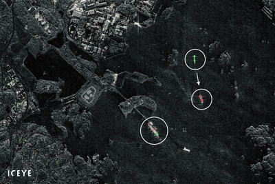
More sophisticated, and more malicious, is “spoofing,” which creates fake signals that convince the receiver it is somewhere it is not.
Done correctly, spoofing can go undetected—and is capable of leading an oil tanker, for example, off course in open water.

High-powered jamming and spoofing are usually the work of armies and intelligence services.
Military ships employ sophisticated anti-jamming technology; as GNSS-guided missiles and drones assume growing roles in combat, the cat-and-mouse of satellite disruption has become a given.
Indeed, as tensions mounted between the U.S.
and Iran in 2019, what appeared to be jamming and spoofing occurred in and near the Strait of Hormuz, the oil-shipping choke point between Iran and the Persian Gulf states.

Tools Chris Nolan uses to teach “celestial navigation.”
Photograph by Jeremy Lange for Fortune

But commercial vessels seldom carry such technology.
That’s worrisome, because small-scale GPS disruption has become something almost anyone can do.
Off-the-shelf jammers, though illegal in the U.S.
and many other countries, are easy to find online for as little as $20, with prices rising as their range increases.
Drug-smuggling networks use jammers to mask their activities; illegal fishing operations use them to obscure where they got their catch.
And thieves who steal shipping containers deploy jammers to block the trackers hidden inside them.

Perhaps more unsettling, spoofing is no longer particularly difficult either.
In 2013, Todd Humphreys, director of the Radionavigation Laboratory at the University of Texas at Austin, spoofed a 213-foot, $80 million yacht.
Last June, an Israeli cybersecurity firm called Regulus announced that it had spoofed a Tesla Model 3. (Tesla dismissed the report as a marketing ploy and said it did not have any safety concerns related to the report.)

As GPS has become democratized, in other words, so has disruption—making interference difficult to track or even quantify.
In 2018, the Coast Guard began publishing excerpts from reports about GPS outages, including those involving “unknown interference”—a category that includes suspected jamming or spoofing.
Those published reports number in the low hundreds worldwide, but Rick Hamilton adds that that’s “a very, very, very small subset of what’s going on out there.”
An EU-funded project, Strike3, underscores how much bigger the problem may be.
From December 2017 to October 2018, it recorded 15,200 interference “events”—of which “many hundreds” were strong enough to disrupt satellite navigation systems entirely.

Beginning in February 2016, ships near the city of Kerch and other ports along the Black Sea began experiencing odd navigation glitches.
Over the following months, GPS locations for thousands of ships appeared to suddenly accelerate and move dozens of miles inland—usually to airports.
These “spoofs” all took place near a geopolitical hotspot: Kerch is in Crimea, which Russia annexed from Ukraine in 2014.

Those incidents turned out to be the leading edge of a wave of GPS interference events involving commercial ships and aircraft.
(See the accompanying timeline.)
Many took place near contested borders or zones of armed conflict.
And one particular region became a locus of anxiety: the eastern Mediterranean.

The region’s biggest shipping conduit is the Suez Canal, which conveys around 1,500 ships a month between the Red Sea and the Mediterranean, many of them oil tankers bound for Asia or the EU.
The “East Med” is also ringed by areas of active combat, including a simmering insurgency on Egypt’s Sinai Peninsula and the devastating multisided conflict in Syria.
And at the hub of this troubled region is Cyprus—whose strategically important ports are refueling points not just for ships using the Suez but also for warships patrolling Syria’s waters.

Tools Chris Nolan uses to teach “celestial navigation.”
Photograph by Jeremy Lange for Fortune

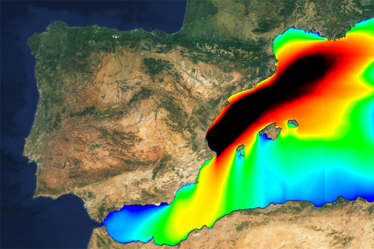
On the south coast of Cyprus, where Stelios Christoforou works, GPS began to act strangely in January 2018.
On vessels offshore or in port, loud alarms would sound as their captains lost the ability to see their GPS location.
The alarms would blare as long as GPS was absent: hours, even entire days.
Other times, the ships’ GPS locations would be visible—but in impossible places.
“Sometimes you see the tugboats in the mountains,” Christoforou says.

The disruptions weren’t confined to Cyprus.
Beginning in 2018, NATO and the U.S. Coast Guard registered outages across much of the East Med—as far north as Turkey, east to Lebanon and Israel, and south to the Mediterranean entrance of the Suez Canal, across a range of at least 65,000 square miles.
“It’s a very congested area, and disruption in GPS and navigation could have devastating consequences,” says Chronis Kapalidis, a former lieutenant commander in the Greek Navy and a maritime security researcher at shipping consultancy HudsonAnalytix.
By the end of 2019, GPS disruptions across the Mediterranean had been reported to the Coast Guard 38 times, referencing hundreds of incidents, including some farther to the west, to the coasts of Libya and Malta.

Unlike with most GPS interference, authorities believe they’ve tracked some East Med disruptions to their source.
Investigations by the European aviation agency Eurocontrol and the Cypriot Department of Electronic Communications connected the outages to jamming signals from Syria and concluded they were a by-product of the conflict there.
(Neither agency has widely publicized the finding, but both confirmed it to Fortune.)

In March 2019, a report by Humphreys, the Texas GPS expert, and the Center for Advanced Defense Studies, a research center in Washington, D.C., went further in assigning blame.
The authors traced the jamming to the Khmeimim air base on Syria’s coast, the “nerve center” of Russia’s military operations in that country—around 137 nautical miles from Vasiliko.
The disruptions were unusually strong and sophisticated, and the authors surmised that they were intended to protect Khmeimim from missiles and drones.
The same report pointed to a Russian role in the 2016 Black Sea spoofing.
It noted that many of those incidents coincided with visits by top Russian officials, including President Vladimir Putin—suggesting a protective effort of another kind.

Russia has consistently denied roles in GPS disruptions; Russian authorities did not respond to requests for comment from Fortune.
But experts caution that Russia’s emergence as a plausible culprit for some interference doesn’t account for the phenomenon’s growing frequency.
In other hotspots, questions about culpability persist.
In the Suez, outages have been variously (and speculatively) blamed on Egyptian authorities fighting insurgents and on illegal fishing.

In December, the NATO Shipping Centre, which works with commercial shippers, said that interference continued in the East Med, with “potentially dangerous consequences.” In Vasiliko, outages have tapered off recently.
Still, Christoforou and his fellow pilots remain on alert in case something goes wrong.
“I worry a little bit when the vessels approach in the night,” he confesses.

At the governmental level, concern over interference is growing, but action isn’t imminent.
Last June, 14 maritime groups wrote to the Coast Guard, asking it to work with the International Maritime Organization to resolve the GPS outage issue.
In December, the Coast Guard told Fortune it was still in talks with the State Department about how to proceed.

With state actors sluggish, responsibility falls to shipowners and ship-management companies.
Shippers have been reluctant to speak openly about the GPS issue, however, or about what they’re doing to bolster their defenses.
Of the 26 ship-management companies contacted for this story, only two, Cyprus’s Lavar Shipping and Norway-based Wilhelmsen, admitted on the record that their ships had experienced GPS interference.

Multiple shipping experts described an industry in transition.
Generally, captains and crews have the skills to cope with GPS outages.
But broader changes over the past 25 years have increased shippers’ dependence on satellite navigation.
Ships have become bigger, faster, and more automated, while crews have shrunk.
Offshore infrastructure has proliferated—think undersea cables, aquaculture, and wind farms—making marine space much more crowded.
At the same time, says Jonathan Turner, director of the English marine consultancy NLA International, a younger generation of sailors “are switching from dependency on their own skills to rely on some machines,” leaving older crew members worried about a “skill fade” among sailors unprepared for life without GPS.

No one interviewed for this story thought the disruptions outweighed GPS’s advantages: charting a course across open waters, making ports more efficient, and rescuing crews in emergencies.
But while a constellation of reinforcement options exist—including more robust anti-jamming receivers, land-based backup systems, or more training—those options cost serious money.
A military-grade anti-jamming antenna, for example, costs about 10 times as much as a regular antenna.

Such investments can seem daunting in an industry that reported profit margins of less than 1% in 2019.
The shipping world is grappling with slowing trade, overcapacity, and new, costly fuel regulations.
The upshot, sources tell Fortune, is that shipowners will be loath to pay much for GPS defenses until outages cross over from a nuisance to a crisis—that is, until a major accident occurs.

More than 5,000 miles from Cyprus, in Beaufort, N.C., Christopher Nolan has made a career of showing merchant mariners how to navigate without GPS.
The former Coast Guard officer teaches “celestial navigation,” which involves determining one’s location using little more than the position of astronomical bodies in relation to the horizon—in essence, the way Magellan did it.

Nolan’s students include college-age kids and amateurs but also mid-career officers.
For them the two-week courses are a requirement for licenses to command large vessels outside U.S.
coastal waters.
Some have studied traditional navigation, but they tend to be rusty.
“It’s a perishable skill,” says Nolan.
“Once you’ve passed your exam, you’re never tested on it again.”
And many younger mariners have never operated in a GPS-free world.

Nolan isn’t alone in bringing old-school methods back into the curriculum.
In 2015, the U.S. Naval Academy resumed teaching celestial navigation to all incoming officers.
The academy attributed the decision in part to the rise of cyberthreats that could impede electronic navigation.
The class of 2017 was the first in at least 15 years to graduate with core training in the discipline.

Navigating by the stars is far less accurate than GPS, and far more time-consuming.
But these basic seafaring skills may soon be tested more frequently than ever before in the GPS era.
Nolan says his wife, Kellee, a commander in the Coast Guard, teaches her subordinates a timeless rule of thumb.
“Look out the window, look at the chart, and look at the GPS,” he says.
“In that order.”


Every year, more dead zones

GPS outages have gradually grown more prevalent over the past four years; many have occurred near global conflict zones.

February 2016: Black Sea ports

Hundreds of ships report seeing their GPS locations suddenly migrate dozens of miles inland.
A report by U.S.
researchers later links many of the incidents to visits to Russian-annexed Crimea by President Vladimir Putin and other senior Russian officials.

March–April 2016: South Korea

A six-day outage near the North Korean border affects more than 1,000 planes and 700 ships.

Late 2017–present: Suez Canal

Persistent GPS outages plague the Egyptian shipping artery.
Potential causes include an insurgency in the nearby Sinai Peninsula and illegal fishing operations.
Fall 2017 and Fall 2018: Russian-Scandinavian frontier

Finnish and Norwegian authorities complain about jamming and spoofing of GPS signals near their borders with Russia during NATO military exercises in the region.
Russian officials deny responsibility.

January 2018–September 2019: Cyprus and the “East Med”

Sporadic outages across the eastern Mediterranean, concentrated around Cyprus and near Lebanon and Israel.
Cypriot and U.S. investigators link the disruption to military activity in Syria.

June–July 2019: Israel

Weeks of disruptions are reported by pilots taking off and landing at Tel Aviv’s Ben Gurion airport.
An Israeli official publicly blames Russia; a Russian official calls the charge “fake news.”

Links :

Wednesday, January 22, 2020

Iceye releases dark vessel detection product

Iceye released a product Jan. 20 to detect vessels at sea that have turned off their Automatic Identification System transponders.
The product is designed to help government agencies, nongovernmental organizations and commercial customers curb drug and human trafficking, find vessels fishing illegally and enforce rules against illegal transshipment of goods.
The image shows dark vessels near the Port of Singapore.
Credit Iceye

From SpaceNews by Debra Werner

Radar satellite operator Iceye released a product Jan. 20 to detect dark vessels, ships at sea that are not identifying themselves with Automatic Identification System (AIS) transponders.

Iceye combines observations from its constellation of three synthetic aperture radar satellites with other data sources to provide customers with radar satellite images of vessels that are not broadcasting their identification, position and course with AIS transponders.
The technology is designed to help government agencies, nongovernmental organizations and commercial customers curb drug and human trafficking, find illegal fishing vessels and enforce rules against illegal transshipment of goods, Finland-based Iceye said in a Jan. 20 news release.

 Dark Vessel Detection solution can detect vessel location information and radar satellite images even when the AIS transponders are turned off
see interactive Demo
credit : Iceye

Dark vessel detection is a popular application for radar satellites which gather data day, night and in all weather conditions, Pekka Laurila, Iceye co-founder and chief strategy officer told SpaceNews. With three satellites in orbit, Iceye offers customers the ability to frequently revisit areas of interest. In addition, the company has developed machine learning algorithms to speed up dark vessel detection, he added.

In this composite visualization, vessels in the port of Gothenburg, Sweden, are detected changing their position with just minutes between two combined SAR satellite images.
Elements shown in green represent the position of elements only seen in the prior image, and elements in red represent elements only in the following image.
One of the vessels is leaving the port, and another is slowly approaching the oil terminal visible in the scene.

Not all vessels that have turned off their AIS transponders are conducting illegal activity.
There are more mundane reasons.
A vessel’s AIS transponder might not be working.

“The intent of a dark vessel detection product is to reduce the search space for customers,” Laurila said.
“They can focus on a few targets versus a very large number.”

Iceye is preparing to expand its constellation from three to five satellites, Laurila said.
Within weeks, Iceye plans to begin operating two additional satellites.
Then, the company will be able to respond more quickly to customers seeking imagery of specific targets and customers seeking frequent imagery updates, he added.

Iceye provides SAR imagery with a range of resolution and swath sizes, including SAR imagery with a resolution of less than one meter.

Links :

Tuesday, January 21, 2020

Can a ‘crowdsourcing’ approach make the American weather model best in the world?

American model forecast for Saturday January 18th, 2019
NOAA

From Forbes by Marshall Shepherd

I just spent last week in Boston at the American Meteorological Society’s Centennial meeting.
It is one of the largest gatherings of weather expertise in the world.
During the week, the word “EPIC” was prevalent in several panel discussions, scientific presentations, and lunchtime conversations.
EPIC stands for Earth Prediction Innovation Center.
Herein, I provide a “101” on EPIC, and some insight on why some believe that it is a game changer for weather forecasting.

I spent 12 years in the government as a scientist at NASA.
I have served on numerous advisory panels for NASA, NOAA, and other government agencies.
With hesitancy, I admit to being able to speak “inside the beltway jargon” though increasingly wary of it as my tenure outside of Washington lengthens.
If you spend any amount of time with NOAA or NASA officials, the conversation often devolves into acronyms and a barrage of buzz-wordy terms that sound like a foreign language to the average citizen.
Yet, it is not uncommon to hear someone in the public talk about the “European vs the American Model.”

It is an amusing discussion because people clearly have some sense that the “Euro” model is superior to the U.S. global forecast system.
However, it is also clear to me that many of those same people think the difference in quality is similar to a “horse and buggy vs a high performance German-engineered car.”
The performance is actually closer to two high-performance cars with one having a bit more features and horsepower.
During my week in Boston among weather experts, it was clear to some colleagues that the EPIC concept was not well-understood so imagine how the public is going to grasp it.

First, let’s review a description of EPIC mentioned in The Weather Research and Forecasting Innovation Act of 2017:
EPIC will advance weather modeling skill, reclaiming and maintaining international leadership in the area of Numerical Weather Prediction, and improving Research to Operations (R2O) by: Leveraging the weather enterprise to provide expertise on removing barriers to improving NWP; Enabling scientists and engineers to effectively collaborate in areas important for improving operational global NWP skill, including model development, data assimilation techniques, system architecture integration, and computational efficiencies; Strengthening NOAA’s ability to undertake research projects in pursuit of substantial advancements in weather forecast skill; Utilizing and leveraging existing resources across NOAA’s enterprise; and Creating a community global weather research modeling system.
Weather Research and Forecasting Innovation Act of 2017
Yep, this sounds like Beltway language doesn’t it.
The Capital Weather Gang’s Jason Samenow has an excellent translation.
Writing in the Washington Post, Samenow said, “Whereas historically it has been difficult for the outside research partners to test, evaluate and provide feedback on the American modeling system, EPIC will provide the framework for a “community modeling” effort.”
Simply put, EPIC will allow experts from across the weather enterprise to work together towards the U.S. modeling system of the future.

Much of the focus on the U.S. standing in weather modeling compared to the Europeans was brought into focus after Hurricane Sandy in 2012.
The “Euro” model saw the “hard left” turn several days in advance that would ultimately bring the storm into the Northeast.
The Europeans invest significantly more resources into the computing and modeling aspects of weather forecasting.
NOAA has to invest in computers, models, satellites, radars, personnel at National Weather Service offices, weather balloons, ocean monitoring, fisheries, instruments, climate prediction and more.
It is a different philosophy rather than the U.S. being “asleep at the wheel.”
Dr. Neil Jacobs, a veteran of the private and public sector, is the interim Administrator of NOAA (his confirmation is pending).
He, with the backing of federal law, is upping the ante on U.S. investments in weather modeling, and EPIC is a key centerpiece of the strategy.

Dr. DaNa Carlis is the Program Manager for EPIC in NOAA’s Office of Weather and Air Quality.
Carlis is as close to the program as anyone and understands the need to clarify the message on EPIC.
His perspective is captured below.
The goal of EPIC is to accelerate scientific advancements from the research community to produce the most accurate and reliable operational modeling system in the world.
NOAA is working closely with the Unified Forecast System (UFS) community to provide its operational modeling suite to the weather enterprise for community-based modeling.
In doing so, NOAA along with our partners will be able to leverage each other's model advancements across systems that are shared and adopted within the UFS framework.
DaNa L. Carlis, Ph.D.
OWAQ Program Manager for NGGPS/EPIC NOAA's Office of Oceanic and Atmospheric Research
Universities, federal labs, and private sector partners will be conducting research through a common infrastructure aligned with NOAA's operational modeling suite.
NOAA officials like Carlis believe this arrangement will accelerate the transition of new ideas and methodologies from research to practical operations.
Carlis told me, “It's an exciting time at NOAA and with the support of the community, we believe we can develop the best weather prediction system in the world.”

This all sounds great, and I will be watching closely.
There will certainly be challenges ahead:
  • Is it a “bricks and mortar” or virtual center?
  • What is the governance structure?
  • How will intellectual property and security issues be resolved?
  • What about competitive advantage vs public good in public-private interactions?
  • How are legacy functions within the NOAA community maintained as resources move into EPIC and/or other community research efforts?
Tropical Storm Imelda drenched parts of Texas in 2019
NASA

These are just questions that I thought of, and I am not a weather modeling expert.
However, during my testimony before the House Science Committee last year, I was very bullish on EPIC and the concept of a “crowdsourced” weather modeling effort.
Challenges with rainfall forecasts in Tropical Depression Imelda in Texas (2019) and rapid intensity changes observed with Hurricane Michael (2018) affirm the need for the EPIC framework.
I believe EPIC is a positive step to ensure a more nimble and responsive U.S.
weather model capability as we keep pace with or attempt to surpass other global modeling efforts.
J.Marshall Shepherd, PhD, University of Georiga, Testimony to U.S. House of Represenatives Science Committee

Links :

Monday, January 20, 2020

Ravenous wild goats ruled this island for over a century. Now, it's being reborn.

The island of Redonda, once thought doomed by ravenous goats and rats.
photo : by Ed Marshall, Redonda Restoration Programme

Frm National Geographic by Michaël Hingston


The rocky island of Redonda, once stripped of its flora and fauna by invasive species, makes an astonishingly quick comeback.
What’s the secret to its recovery?


It takes four hours to sail to Redonda, but only two minutes of wandering around here before the first dragon appears.

This tiny, secluded island in the Caribbean West Indies, an imposing piece of old volcano ringed by hundred-foot cliffs, is covered with bushes and knee-high grass that can obscure some of the unusual species that call it home.
The nests of various boobies and frigate birds are scattered amidst the greenery underfoot, while their owners dot the sky overhead by the dozens.
Tree lizards and pygmy geckos, both native to the island, linger in nearby patches of shade.
And the Redonda ground dragon, a rare, six-inch, all-black lizard, is even bolder: I stop walking for a few seconds and lean against the rusted remains of a cable head, and an entire lounge of them emerges and runs across my sneakers.

 Redonda island with the GeoGarage platform (NGA nautical raster chart)

It wasn’t always this way.
In fact, if you’d visited Redonda even five years ago—no easy feat, then or now—you’d have seen a place that locals from nearby Antigua (of which Redonda is technically part) had written off as a dying island falling into the sea.
For a half century in the late 19th and early 20th centuries, Redonda bustled with activity as the site of a mine that used a large pulley system to lower buckets of guano and phosphates—used as fertilizer—down to the shoreline below.
More than 100 men were employed at the mine’s peak, most of whom lived full time on the island.

But the mine shut down following the outbreak of World War I, and two critical things were left behind: goats and rats.
For the next hundred years, these foreign species would team up to eat everything in sight until there was nothing left but dust and scraps of old machinery.

In recent years, however, a stunning ecological turnaround has taken place on Redonda at a rate faster than even its most optimistic supporters could have imagined.
For many people, “rewilding” brings to mind a quiet and passive process, like stepping away from a garden to let the natural weeds back in.
For the Redonda Restoration Programme, rewilding has been a more complicated journey involving helicopters, goats wrapped in plastic, mountaineers armed with rat poison, and protective gear made out of pool noodles and yoga pants.

Long gone? Not so fast.

For a long time, Redonda was assumed to be beyond repair, in part because of the scope of the damage from the animals, in part because of the island’s inaccessibility, and in part because the very idea of conservation took time to catch on in the area.

“By and large, conservation in Antigua is seen as an elitist thing,” says Natalya Lawrence, a coordinator with the non-profit Environmental Awareness Group, which oversees the Redonda restoration project.

The Redonda tree lizard (Anolis nubilus), one of the reptiles that rebounded after invasive species were removed from the island.
photo by Ed Marshall

“If you have money, you can be concerned with trees and lizards.
But if you need a dollar today to feed your children today, you don’t really have time to see the long-term effects.”

The EAG was started in the late 1980s and has since grown to include many restoration projects in and around Antigua.
Over the past few decades, they’ve managed to eradicate rats from more than a dozen islands in the area.
Still, Redonda, which looms on the southwest horizon, was always the organization’s dream project.
And finally, in 2016, after multiple rounds of stakeholder consultations and feasibility studies, a group of volunteers set up camp on the island’s main plateau and got to work.

Goats on Redonda before they were airlifted to Antigua.

The first step was relocating Redonda’s herd of approximately 60 wild goats.
Volunteers went in with a plan, but after two months they’d only managed to capture a single animal.
“Those goats were so smart,” remembers Shanna Challenger, coordinator for the Redonda Restoration Programme, with a laugh.
“They would look at our snares, and jump over them.”

Lures of food and fresh water had no effect, either.
In the end, a larger group of workers managed to round up the goats by hand and transport them off of the island via helicopter.
To keep them calm, each goat was placed up to its neck in a plastic bag, was blindfolded with a hood made of old yoga pants, and had its horns protected with foam pool noodles for the 20-minute flight back to Antigua.

At the same time, that larger group (which included representatives from several organizations, including Fauna and Flora International and Wildlife Management International) was also tasked with eradicating the roughly 6,000 black rats that had infested every corner of the island.
Those rats were big and they were voracious: By the time workers returned to check on their poisoned traps, other rats had already started eating their dead brethren.
And because so much of Redonda is virtually inaccessible to humans, the EAG also hired climbers from the British Mountaineering Council to scale the cliffs and plant poison in the island’s hardest-to-reach nooks and crannies.

Once the goats and rats were officially gone, the EAG decided to wait to see what kinds of regrowth would happen naturally before taking further action.
As it turned out, they didn’t need to do much of anything.
Within a year, land-bird populations had increased tenfold.
Rare endemic species like the ground dragon and tree lizard have seen their populations spike as well.
Even the color of the island itself has changed, from brown to green, as the native grasses and trees have returned more quickly than expected.
A study from 2012 counted 17 different types of vegetation growing on Redonda; the latest count, from 2019, showed 88.

 photograph courtesy EAG Antigua

Plans for the future

As with many conservation projects, there’s no such thing as a hard-and-fast completion date.
While human visitors to Redonda remain few and far between, the EAG continues to monitor the island to make sure that the regrowth continues apace, and that rats or other invasive species don’t suddenly reappear.
A plan to turn Redonda and its surrounding waters into a permanent nature reserve, meanwhile, is currently before the Antiguan government.

Either way, for the EAG, Redonda is already a capstone in decades of rewilding work.
The speed of the island’s regrowth demonstrates not only that conservation is effective, but also that even the most seemingly barren places can be saved.
“With a little bit of help,” Challenger says, “nature can recover.”

Lawrence says she hopes that people around the world will admire Redonda, but also understand and celebrate all of the hidden work that goes into a rewilding project of this scale.
It’s easy, she says, for people to marvel at how beautiful an island is.
“But they don’t know the work that goes into keeping it that way.”

Links :

Sunday, January 19, 2020

Le Belem : le film

Le Belem - Le film from dolly on Vimeo.
Manon discovers the ship and life on board.
A nice trip in the Baltic during the 2019 season, a trip open to all...
"There is no place where one can breathe more freely than on the deck of a ship."
Elsa Triolet