This stunning image by amateur photographer Nima Sarikhani just won the Wildlife Photographer of the Year People's Choice Award.
"Sarikhani's breathtaking and poignant image allows us to see the beauty and fragility of our planet," Natural History Museum director Dr Douglas Gurr said.
"His thought-provoking image is a stark reminder of the integral bond between an animal and its habitat and serves as a visual representation of the detrimental impacts of climate warming and habitat loss."
Sarikhani made the image after three days searching for polar bears through thick fog off Norway's Svalbard archipelago.
It’s the body of water that instils fear and inspires sailors in equal measure. Six hundred miles of open sea, and some of the roughest conditions on the planet – with an equally inhospitable land of snow and ice awaiting you at the end of it.
“The most dreaded bit of ocean on the globe – and rightly so,” Alfred Lansing wrote of explorer Ernest Shackleton’s 1916 voyage across it in a small lifeboat. It is, of course, the Drake Passage, connecting the southern tip of the South American continent with the northernmost point of the Antarctic Peninsula.
Once the preserve of explorers and sea dogs, the Drake is today a daunting challenge for an ever-increasing number of travelers to Antarctica – and not just because it takes up to 48 hours to cross it. For many, being able to boast of surviving the “Drake shake” is part of the attraction of going to the “white continent.” But what causes those “shakes,” which can see waves topping nearly 50 feet battering the ships? And how do sailors navigate the planet’s wildest waters? For oceanographers, it turns out, the Drake is a fascinating place because of what’s going on under the surface of those thrashing waters. And for ship captains, it’s a challenge that needs to be approached with a healthy dose of fear.
The world’s strongest storms
The Drake Passage can see waves of up to 49 feet. Mike Hill/Stone RF/Getty Images
At around 600 miles wide and up to 6,000 meters (nearly four miles) deep, the Drake is objectively a vast body of water. To us, that is. To the planet as a whole, less so.
The Antarctic Peninsula, where tourists visit, isn’t even Antarctica proper. It’s a thinning peninsula, rotating northwards from the vast continent of Antarctica, and reaching towards the southern tip of South America – the two pointing towards each other, a bit like a tectonic version of Michelangelo’s “Creation of Adam” in the Sistine Chapel.
That creates a pinch point effect, with the water being squeezed between the two land masses – the ocean is surging through the gap between the continents.
“It’s the only place in the world where those winds can push all around the globe without hitting land – and land tends to dampen storms,” says oceanographer Alexander Brearley, head of open oceans at the British Antarctic Survey.
Winds tend to blow west to east, he says – and the latitudes of 40 to 60 are notorious for strong winds. Hence their nicknames of the “roaring forties,” “furious fifties” and “screaming sixties” (Antarctica officially starts at 60 degrees).
But winds are slowed by landmass – which is why Atlantic storms tend to smash into Ireland and the UK (as they did, causing havoc, with Storm Isha in January buffeting planes to entirely different countries) and then weaken as they continue east to the European continent.
With no land to slow them down at the Drake’s latitude anywhere on the planet, winds can hurtle around the globe, gathering pace – and smashing into ships.
Drake Passage with the GeoGarage platform (UKHO nautical raster map)
“In the middle of the Drake Passage the winds may have blown over thousands of kilometers to where you are,” says Brearley. “Kinetic energy is converted from wind into waves, and builds up storm waves.” Those can reach up to 15 meters, or 49 feet, he says. Although before you get too alarmed, know that the mean wave height on the Drake is rather less – four to five meters, or 13-16 feet. That’s still double what you’ll find in the Atlantic, by way of comparison.
And it’s not just the winds making the waters rough – the Drake is basically one big surge of water. “The Southern Ocean is very stormy in general [but] in the Drake you’re really squeezing [the water] between the Antarctic and the southern hemisphere,” he adds. “That intensifies the storms as they come through.” He calls it a “funneling effect.”
Then there’s the speed at which the water is thrashing through. The Drake is part of the most voluminous ocean current in the world, with up to 5,300 million cubic feet flowing per second. Squeezed into the narrow passage, the current increases, traveling west to east. Brearley says that at surface level, that current is less perceptible – just a couple of knots – so you won’t really sense it onboard. “But it does mean you’ll travel a bit more slowly,” he says.
For oceanographers, he says, the Drake is “a fascinating place.”
It’s home to what he calls “underwater mountains” below the surface – and the enormous current squeezing through the (relatively) narrow passage causes waves to break against them underwater. These “internal waves,” as he calls them, create vortices which bring colder water from the depths of the ocean higher up – important for the planet’s climate.
“It’s not just turbulent at the surface, though obviously that’s what you feel the most – but it’s actually turbulent all the way through the water column,” says Brearley, who regularly crosses the Drake on a research ship. Does he get scared?
“I don’t think I’ve ever been really fearful, but it can be very unpleasant in terms of how rough it is,” he says candidly. Fear breeds fear
In 2010, tourist ship Clelia II declared an emergency after suffering engine failure in the Drake.
Fiona Stewart, Garett McIntosh/AP
One other key thing that makes the Drake so scary: our fear of the Drake itself.
Brearley points out that until the Panama Canal opened in 1914, ships going from Europe to the west coast of the Americas had to dip round Cape Horn – the southern tip of South America – and then trundle up the Pacific coast.
“Let’s say you were shipping goods from western Europe to California. You either had to offload them in New York and do the journey across the US, or you had to go all the way around,” he says. It wasn’t just large cargo ships, either; passenger ships made the same route.
There’s even a monument at the tip of Cape Horn, in memorial of the more than 10,000 sailors who are believed to have died traveling through.
“The routes between the south of South Africa and Australia, or Australia or New Zealand to Antarctica, don’t really lie on any major shipping routes,” says Brearley. “The reason it’s been so feared over the centuries is because the Drake is where ships really have to go. Other parts [of the Southern Ocean] can be avoided.”
‘We don’t gamble’
Captain Stanislas Devorsine regularly crosses the Drake. Sue Flood/Ponant Photo Ambassador
Navigating the Drake is an extremely complex task that demands humility and a side of fear, says Captain Stanislas Devorsine, one of three captains of Le Commandant Charcot, a polar vessel of adventure cruise company Ponant. “You have to have a healthy fear,” he says of the Drake. “It’s something that keeps you focused, alert, sensitive to the ship and the weather. You need to be aware that it can be dangerous – that it’s never routine.”
Devorsine made his Drake debut as a captain over 20 years ago, sailing an icebreaker full of scientists over to Antarctica for a research stint. “We had very, very rough seas – more than 20 meter [66 feet] swells,” he says. “It was very windy, very rough.” Not that Ponant’s clients face anything like that. Devorsine is quick to point out that the comfort levels for a research ship – and the conditions it will sail in – are very different from those for a cruise. “We are extremely cautious – the ocean is stronger than us,” he says. “We’re not able to go in terrible weather. We go in rough seas but always with a big safety margin. We’re not gambling.”
Even with that extra safety margin, though, he admits that crossing the Drake can be a hairy experience. “It can be very rough and very dangerous, so we take special care,” he says. “We have to choose the best time to cross the Drake. We have to adapt our course – sometimes we don’t head in our final direction, we alter the course to have a better angle with the waves. We might slow down to leave a low pressure path ahead, or speed up to pass one before it arrives.” The ‘Drake shake’ and broken plates
Captains check the weather up to six times a day before departure to ensure a safe crossing. Jamie Lafferty
Of course, every time you get on a ship – whether it’s a simple ferry ride or a fancy cruise – the crew will already have meticulously planned the journey, checking everything from the weather to the tides and currents. But planning for a crossing of the Drake is on a whole new level.
Weather forecasting has improved in the two decades since Devorsine’s first ride, he says – and these days crew start planning the voyage while passengers are making their way to South America from all over the globe.
Sometimes they leave late; sometimes they head back early, to beat bad weather. Devorsine – who makes the return journey about six to eight times per year – estimates that the unusually calm “Drake lake” effect happens once in every 10 crossings, with particularly rough conditions (that “Drake shake”) once or twice in every 10 journeys.
Of course, he knows what’s in store long before the passengers reach the ship.
“We look ahead to have the best option to cross. Normally I look at the weather 10 days or a week before, just to have an idea of what it could be,” he says.
“Then I check the forecast once per day, then two or three days before departure I start looking at it twice per day. If it’s going to be a challenging passage you look every six hours. If you have to adjust your departure time, then you look at it very closely to be very accurate.”
His safety margin means that he’s calculating a route that will get you across not just alive, but also as comfortably as possible. Hearing an anecdote about broken crockery and furniture on another operator, he sighs, “That’s a bit too far for me.”
“Before you have any issue with a storm, you have to keep a comfortable ship,” he says. The safety margin is to be sure that the guests will enjoy being in Antarctica, and that we won’t turn around because we have a problem… like injured people.”
In extreme conditions, he orders extra weather advice from Ponant HQ, but if you’re imagining the staff on the bridge desperately radioing for advice as waves batter the ship, think again.
“It would never happen to be in the middle of the Drake with bad conditions, needing assistance from headquarters because it would mean we didn’t have any safety margin before departure. When we cross and it’s going to be challenging, we have a big safety margin and the ship is not at all in danger.”
They are in contact with headquarters with high level satellite antennae throughout the crossing, with both satellite and radio backup if needed – Devorsine says he can’t imagine ever losing contact, whatever the weather.
A dangerous thrill
Aurora Expeditions' Greg Mortimer ship has a patented bow to make a Drake crossing more stable. Tyson Mayr/Aurora Expeditions
Devorsine, who now spends 90% of his time sailing in polar waters, feels at home on the Drake. “When I was a little child, I read books about the maritime adventures of sailors and polar heroes,” he says. “I was attracted by tough things – I like challenges. This is why I followed the path to be able to sail in these areas.”
His first experience of the area was doing a “race around the world” in a sailboat as a youngster, heading south from his native France and rounding Cape Horn. “It was my dream because it’s difficult, dangerous and challenging,” he says.
He’s not the only one. Some guests are drawn to Antarctica trips because of the tough journey. “I guess [they] are attracted by these areas [of the Southern Ocean] because it’s wild, it can be rough, and it’s a unique experience to go there,” he says.
Not everone’s a thrill-seeker though. As managing director of Mundy Adventures, an adventure travel agency, Edwina Lonsdale is dealing with a clientele already used to discomfort – yet she says crossing the Drake is a “conversation topic” during booking. “it’s something we would raise to make sure people are completely aware of what they’re buying,” she says. “[Going to Antarctica] is a huge investment – you need to talk through every aspect and make sure nothing’s an absolute no.”
Lonsdale advises that passengers nervous of feeling sick should choose their ship carefully. In the past, vessels heading to Antarctica tended to be uncomfortable metal boxes built to take a heavy beating. But in recent years, companies have introduced more technically advanced vessels: like Le Commandant Charcot, which was the world’s first passenger vessel with a Polar Class 2 hull – meaning it can go deeper and further into the ice in polar regions – when it debuted in 2021.
Movie recorded on an Expedition Cruise to the Antarctic Circle, February/March 2011.
On Sunday 6th March we were sailing through the Drake Passage back to mainland Argentina on our ship, the MS Expedition, when a big storm blew up.
The Captain reported it was a Force 12, with gusts of wind upto 70 Knots and 30-40ft waves/swell. Certainly a lovely and exciting crossing, and totally living upto the name "Drake Shake", when storms like this happen on this stretch of water.
Two of Aurora Expeditions’ ships, the Greg Mortimer and Sylvia Earle, use a patented inverted bow, designed to slide gently through the waves, reducing impact and vibration and improving stability, rather than “punching” through the water as a regular bow shape does, which makes the bow rock up and down.
Lonsdale says that the fancier the vessel and the offerings onboard, the more distractions you’ll have if bad weather hits. Newer boats often have more spacious rooms and bigger windows so that you can watch the horizon, which helps to lessen seasickness. If the budget allows, she says, book a suite – you won’t just get more space, you’ll (likely) have floor-to-ceiling windows, too.
But a word of advice – she recommends a careful selection not just of the right operator for you, but of the ship itself. “Just because a company has a fleet with a very modern ship doesn’t mean the whole fleet will be like that,” she says.
‘Act before you start spewing’
At Cape Horn there's a monument marking the 10,000 sailors thought to have died navigating the Drake. DreamPictures/Photodisc/Getty Images
So you’ve conquered your fears, booked your ticket and you’re about to set sail. Bad news: the captain is predicting the Drake shake. What to do?
Hopefully you’ve come prepared. Most ships have ginger candies on offer during bad weather, but bring your own, as well as any anti-seasickness medication you want to take. Some passengers swear by acupressure “seeds”: tiny spikes, attached to your ears with a sticking plaster, designed to stimulate acupuncture points. Some ships offer acupuncture onboard; alternatively you can get it done beforehand, since the seeds last for some time.
Devorsine’s top tips are to keep your eyes on the horizon, hold onto the handrail when walking around, be careful around doors, and “don’t jump out of bed.”
Jamie Lafferty, a photographer who leads excursions on Antarctic cruises, says that of his 30-odd crossings, “I’ve had one where it felt like I was going to fall out of bed and that was the second time, way back in 2010 when there was a lot more guesswork involved. Crossing the Drake Passage is much, much more benign than it used to be thanks to the accuracy of modern forecasting models and stabilizers on more modern cruise ships. This doesn’t mean it’ll be smooth, but it’s vastly less chaotic and unpredictable than it used to be.”
His top tip? “Take seasickness medication before heading out into open sea – once you start spewing, tablets aren’t going to be any use.”
Warren Cairns, senior researcher at the Institute of Polar Sciences of the National Research Council of Italy, has a bit of extra help.
“The only thing that works for me is going to the ship’s medic for a scopolamine patch,” he says. “It’s so rough, normal seasickness pills are just to get me to the infirmary.” Although he has it worse than the average tourist – on trips to Antarctica, their research ships have to pause for hours to take samples. “The waves come from all sorts of directions as the thrusters keep it in place,” he says. “When you’re underway it’s a much more regular motion.”
Lonsdale says it’s important not to fight it if you feel ill: “Just go to bed.” But equally, she says, don’t expect it: “It may be calm. You may not feel ill.”
People suffer differently from seasickness she says. “The Pacific has very long, slow swells, Channel crossings [between the UK and France] have quite a bouncy experience. Lots of people say crossing the Drake in very rough weather is uneven enough to not make them ill at all.” On that plate-smashing crossing, for example, this reporter – who was watching 40-foot waves from the observation deck – never got sick.
Remember that however it feels, you’re safe. “There’s an extraordinary level of safety in the build of those ships doing this,” says Lonsdale. Add in the safety margins that the likes of Devorsine build in, and you’re in uncomfortable, but not dangerous, territory.
And if all else fails, remember why you’re there.
“The motivation and excitement to discover those latitudes is very important to fight the seasickness,” says Devorsine. Lonsdale agrees. “If you were going to the moon, you’d expect the journey to be uncomfortable but it’d be worth it,” she says. “You just have to think, ‘This is what I need to get from one world to another.’”
Which is annoying; wave energy is super-reliable, super-predictable, and available 24/7 at coastlines worldwide, which is right where a lot of people tend to like living.
It should be a dream addition to the renewable energy mix.
But it's moving so slowly that you have to wonder where the holdup is.
WaveRoller - Plug Into Wave Energy
The idea behind the Waveroller struck when a diver noticed a large hatch on a shipwreck moving back and forth with considerable power as waves passed over it, and wondered if the same "surge" effect, which causes water particles to move back and forth in horizontal elliptical shapes close to the shore, could be harnessed to drive a hydraulic piston and generate electricity.
That light bulb moment was in 1993, when Michael Jordan was cementing Charles Barkeley's legacy as a ringless wonder in the NBA Finals, and The Simpsons was hitting its stride in season five.
We're talking "who needs a Quickie-Mart" and Homer joining a barbershop quartet.
That long ago.
It took until 1999 to test a proof of concept, then until 2005 before small-scale test farms were installed in Scotland and Ecuador, then until 2016 to get a design manufactured, assembled, tested and certified around Europe.
The first commercial WaveRoller, a 350-kW unit, was connected to the grid in 2019, 800 m (2,600 ft) off the Portuguese coast at Peniche.
Here it is, brand spankers, being towed out and deployed.
WaveRoller deployment
Aaaand here it is, being pulled out for inspection two years later.
Part of the problem might be fairly clear; the ocean is a harsh mistress.
Anything you leave in there is battered by salt, eaten by corrosion and merrily settled by barnacles
Mind you, AW Energy wasn't unhappy with this result: "We are delighted to confirm that the unit and its external components are in excellent condition, just take a look at the photo as proof of this system’s durability and quality," reads the company Facebook page from the day it was hauled ashore.
Since 2020, the company has worked on a project supported by EU funding, to adapt the WaveRoller and its associated bits and pieces for serial manufacturing, as well as for deployment in arrays of between 10-24 WaveRoller units.
These arrays, called WaveFarms, will sit on the sea bed between 8 and 12 meters of depth, no further than 2 km (1.3 miles) from shore.
Each WaveRoller is rated for 1 MW of peak power production, and in a 2023 study published in Renewable Energy, we learn that each is expected to produce between 624-813 MWh per year.
In terms of levelized cost of energy (LCoE), the WaveRoller comes out by far the most cost-competitive of the five technologies studied, with a LCoE of US$100-150/MWh.
That's well within reach of offshore wind, for comparison, which cost somewhere between US$82-255/MWh in 2022 according to the US DoE, and has enjoyed many years of commercial development to get costs into that ballpark.
The WaveRoller sits on the sea floor, partially or fully submerged, harnessing the surge effect caused by waves as they approach the shore
Matthew Pech, CFO of AW-Energy, said in a press release that WaveRoller can “deliver electricity closer to baseload power than other renewables, and keep Europe at the forefront of innovative renewable technologies.”
The WaveFarm project "enabled AW-Energy to take significant steps towards positive cash generation, both for the company and the European ocean energy sector, by readying the technology and the company for commercial deployment of the devices, and in developing the sales pipeline itself. ”
The company "envisions a global project pipeline of 150 MW for the WaveFarm solution," and "anticipates an addition of €275 million to the European economy and the creation of 500 jobs over the next decade."
Said pipeline is looking a tad bare as it stands; the company has signed a memorandum of understanding (MoU) with a clean energy company in Namibia, with a view to deploy a WaveFarm on the coast of Swakopmud.
The MoU is a rather slippery document, worth more than a handshake but much less than a contract. That's about all we can find at this point, no matter how much the company is envisioning.
Forgive our impatience here, but we're gunning for cost-effective clean energy solutions that can bolster renewable power grids globally.
It's been 31 years since the light bulb moment in this case, so how long's it going to be until waves are powering more actual light bulbs?
The United Nations believes that there are at least three million shipwrecks on the ocean floors, sparking a centuries-long obsession with these sunken vessels and the wealth they might carry.
Shipwrecks–there’s something infinitely fascinating about them. Whether it be a wreck as famous as the Titanic or the lesser-known shipwrecks of the Great Lakes, every single one of them is interesting. These shipwrecks have spawned books, movies, and even songs like Gordon Lightfoot’s “The Wreck of the Edmund Fitzgerald”.
Maritime history is full to the brim of shipwreck stories, and their individual tales of heroism, tragedy, and everything in between.
For those interested in the history of shipwrecks, there is plenty of material to keep them busy, because it’s estimated that there are at least 3 million shipwrecks scattered across the ocean floors.
Here we won’t be able to go over those 3 million wrecks, but we are going to take a look at the most famous shipwrecks in history. When it comes to man versus the power of the ocean (or lake!) we don’t always win, and these shipwrecks offer a stark reminder of that truth.
The USS Arizona
Name: USS Arizona (BB-39) Type of Ship: Pennsylvania-class battleship Length: 608 ft (185.3 m) Date of Wreck: December 7, 1942 Reason for Wreck: Sunk during the attack on Pearl Harbor
The USS Arizona was the second Pennsylvania-class battleship ever built, and it would be the last. Like other ships on that fateful day, the USS Arizona was sunk when Japan launched its attack on Pearl Harbor off the coast of Hawaii.
Just past 8 a.m. on December 7, ten Nakajima B5N2 Japanese torpedo bombers attacked the Arizona. The Arizona was hit by a number of bombs, causing the battleship to sink beneath the waves, killing 1,177 crew members that were aboard.
USS Arizona
While the four hits landed by the Japanese planes were the catalyst for the sinking, what truly destroyed the battleship was the magazine explosion that detonated in response to the bombs.
The results of the magazine explosion were devastating, sealing the fate of the USS Arizona.
In 1989, the USS Arizona was declared a National Historic Landmark. It remains where it sank, and is visited by over 2 million people a year.
RMS Titanic
Name: RMS Titanic Type of Ship: Olympic-class ocean liner Length: 882 ft 9 in (269.1 m) Date of Wreck: April 15, 1912 Reason for Wreck: Struck an iceberg, broke in half, and sank.
No list of famous shipwrecks is complete without the RMS Titanic. Once called the unsinkable ship, the RMS Titanic sank on its maiden voyage, cementing itself in history as the most memorable shipwreck of all time.
When the ship went down, it took 1,514 lives with it. The Titanic’s tragic sinking inspired media such as James Cameron’s 1997 hit movie Titanic.
In 1985 an expedition was finally able to find the remains of the Titanic, and this allowed the discovery that the ship had been split in two before sinking. For the first time since its sinking, the world was able to look upon the Titanic once more, reigniting interest in the ship that is still going strong today.
Subsequent expeditions to the Titanic have been fairly common, but the depth that the ship is at makes visiting it incredibly dangerous.
This was made tragically apparent when in June 2023 a submarine, Titan, created by the company OceanGate was lost while taking civilians down to see the Titanic. The small submersible imploded, and all 5 lives on board were lost.
RMS Lusitania
Name: RMS Lusitania Type of Ship: Ocean liner Length: 787 ft (239.9 m) Date of Wreck: May 7, 1915 Reason for Wreck: Hit by a torpedo fired from a German U-boat
Unlike the aforementioned ocean liner, the Titanic, the RMS Lusitania lived a long and productive life before her sinking. Lusitania completed 202 trans-Atlantic crossings during her time in service.
During World War I, many ships were converted for battle, and while Lusitania could be converted to an armed merchant cruiser if needed, she was operating as a commercial passenger ship (although she was carrying some munitions, they made up a small portion of her total cargo).
It was during one of these commercial cruises when a torpedo from German U-boat U-20 struck her on the starboard bow.
The loss of life was catastrophic–out of 1,962 passengers and crew, 1,191 perished.
It didn’t take long to locate the wreckage of the Lusitania–it was found on October 6, 1935, only 11 miles from the lighthouse at Kinsale, Ireland. Due to the nature of its sinking, it was in poor shape, but four propellers were recovered, with three being put on display.
The sinking of the Lusitania caused anger and shock to ripple across the world, and along with Pearl Harbor, her sinking greatly contributed to the US joining World War II.
HMS Erebus and Terror
Name: HMS Erebus and HMS Terror Type of Ship: Hecla-class bomb vessel and Vesuvius-class bomb vessel Length: 105 ft (32 m) and 102 ft (31.09 m) Date of Wreck: Roughly assumed to have been abandoned in April of 1848 Reason for Wreck: Caught in ice flow, damaged, and abandoned.
Once one of the greatest mysteries in maritime history, some light has been shed on the sinking of the Erebus and Terror in recent years, but there are still countless unanswered questions.
Unlike most of the ships on our list, it’s difficult to pinpoint when the Erebus and Terror sank, but what we do know is that the entire crew of both ships were lost.
The Erebus and Terror set off from Europe to find the Northwest Passage in 1845. The expedition was named after the captain of the Erebus, Captain Sir John Franklin. Within 3 years, the ships were abandoned, trapped in the ice, and hopelessly stuck.
What happened to the crew from there is still unknown, but some hypotheses are death by exposure after abandoning the ships or lead poisoning from faulty welding on the cans of food.
Many missions were sent out over the years to discover the fate of the Franklin Expedition, but it wasn’t until September 2, 2014, that the Erebus was discovered. Almost exactly two years later on September 3, 2016, the Terror was also found.
Both wrecks were in amazing condition considering how old they were. Remarkably, the ship’s bell was recovered from the Erebus and can be viewed at Nattilik Heritage Centre, in Gjoa Haven, King William Island, Nunavut, Canada.
SS Sultana
Name: Sultana Type of Ship: Steamboat Length: 260 feet Date of Wreck: April 27, 1865 Reason for Wreck: Boiler explosion caused by faulty repairs
It might surprise you to learn that the deadliest maritime disaster in United States history isn’t an ocean liner or even a battleship. The holder of this unfortunate record is actually a steamboat, called the SS Sultana, and she went down in the Mississippi River.
Sultana was a passenger steamboat, and her capacity was listed at 376 passengers. On the morning of April 15, 1865, steamboat Captain James Mason was offered a deal.
A boat was needed to take released Union prisoners of war from the south to the northern states now that they were free. Mason would be paid by the head for the prisoners he could take, and he readily agreed.
On April 24, she was loaded with prisoners as well as normal passengers and crew members. Despite the Sultana only having a capacity of 376, she was severely overloaded, and by the time she left port she was carrying 2,128 people.
The overloaded ship, combined with a faulty boiler that had only been haphazardly repaired, was a recipe for disaster.
On the night of April 27, the boilers on board violently exploded without warning. The hot steam and the force of the explosion killed many people in an instant. The steamboat caught fire once the furnace boxes were exposed, and even more lives were lost when the damaged smokestacks began to collapse on passengers.
Those who survived the initial blast had to compete with the freezing water of the Mississippi. Luckily, some were saved by other nearby ships, but many weren’t so fortunate.
The wreck of the Sultana was not found at the bottom of the river when it was discovered. Instead, the burnt wreckage was found in 1982 beneath a Soybean field in Arkansas.
This strange placement occurred because of the Mississippi River’s ever-changing course, which left the remains of the tragic steamboat on dry land.
MV Doña Paz
Name: MV Doña Paz (formerly the Himeyuri Maru) Type of Ship: Passenger ferry Length: 305 ft (93.1 m) Date of Wreck: December 20, 1987 Reason for Wreck: Collision with the MT Vector
When the Doña Paz was first built, she went by a much different name, the Himeyuri Maru. Built in Japan, Doña Paz was launched in 1963, but by 1975 she was purchased by a shipping line in the Philippines known as Sulpicio Lines.
The capacity of the Doña Paz was 1,518 passengers, but the night she sank, she was severely overcrowded and was carrying over 4,000 passengers.
Thousands of these passengers were not listed on the manifest, making rescue and recovery even more difficult.
Doña Paz was on the way to Manila when, on December 20, 1987, she collided with an oil tanker called the MT Vector.
The collision itself was terrible and violent, but it also caused oil to leak from the Vector and both ships to catch fire. One survivor recounts that there was so much oil that even the sea was burning.
Along with being overcrowded, the Doña Paz was wholly unfit for any sort of passenger travel, but this wasn’t known until it was too late.
Sources suggest that the Doña Paz didn’t have a radio, making it impossible for the Vector to warn them of the oncoming collision. This also made it impossible for Doña Paz to call for help once she was struck. Even worse, the crew made no efforts to organize or provide any assistance to the passengers in the panic.
But the worst piece of negligence discovered was that the life jacket lockers were locked up.
Doña Paz sank in two hours, and her few survivors were forced into the freezing, shark-filled water in the dark. They were surrounded by the dead and the drowning with no life jackets and no sense of where they were. Two hours after that, the Vector sank as well.
The sinking of the Doña Paz is the deadliest peacetime disaster in maritime history. While the true number of passengers is unknown, when combined with the death toll from the Vector, 4,385 people died that night, and only 26 would survive.
The wrecks of both the Doña Paz and the Vector were found at the same time, in April 2019. Video footage of the discovery was released, and both ships were found to be in good condition.
SS Edmund Fitzgerald
Name: SS Edmund Fitzgerald Type of Ship: Lake freighter Length: 729 ft (222 m) Date of Wreck: November 10, 1975 Reason for Wreck: Lost in a storm on Lake Superior
When she was launched, the Edmund Fitzgerald was the largest ship on the Great Lakes, and while she doesn’t hold that distinction anymore, she does remain the largest to ever sink on the Great Lakes.
The sinking of the Edmund Fitzgerald is somewhat of a mystery–not for the reason, which was unquestionably the storm over Lake Superior that night–but in the details. The last time the ship was radioed, her captain answered a simple “We’re holding our own.”
And the Edmund Fitzgerald was never heard from again.
We don’t have an exact time that the Edmund Fitzgerald went down, but we do know that it was on November 10, 1975. At the time, the storm that the ship was mired in had sustained winds over 50 knots, and waves as high as 25 were recorded.
By the time she sank, Edmund Fitzgerald had reported to the ship that was following behind, the Arthur M. Anderson, that she was taking on water, and that the ship had developed a list.
Not long after that report, Captain Earnest M. McSorley of the Edmund Fitzgerald radioed the Arthur M. Anderson to let her know that the radar on the Fitzgerald had failed and asked the Anderson to keep track of the ailing ship.
The last haunting correspondence was received on the Anderson at 7:10 p.m. that night. The Anderson couldn’t find Fitzgerlad on their radar, and there was no sign of the bigger ship.
Captain Cooper of the Arthur M. Anderson was a hero that night, even if the Edmund Fitzgerald was lost. Cooper waited only nine minutes after the last transmission to call the United States Coast Guard and report trouble for the other ship.
He was initially brushed off, and Cooper contacted other ships to have them check their radar for the Edmund Fitzgerald instead, to no avail. He continued to call the USCG throughout the night until finally he was taken seriously.
The discovery of the wreck of the Edmund Fitzgerald was accomplished by a U.S. Navy Lockheed P-3 Orion aircraft that was used to detect magnetic anomalies–usually submarines, but in this case, the lake freighter–on November 14, 1975.
Ukraine wants to keep trade flowing and destroy Russia’s fleet
On september 19th military and civil shipping officers huddled in a secret control room to watch the Resilient Africa as it departed Odessa’s Chornomorsk port. As the first vessel to enter and leave using Ukraine’s new emergency shipping corridor, established after the collapse of a un-brokered grain deal, tensions were high. Russia had warned it could open fire on ships using the corridor. Emergency services were on standby. “We readied ourselves for any scenario,” says one of those present in the room. “We were really quite nervous.” In the event, the ship sailed without incident, hugging 150km of Ukrainian coastline before entering first Romanian, then Bulgarian territorial waters, and continuing on through the Bosphorus to its eventual destination, Haifa.
The declaration of a shipping corridor in defiance of Russian bombardment was always going to be risky. But for Ukraine, it was a strategic necessity. Before the war, 60% of the country’s trade went through its deep-sea ports, travelling to markets in Africa and the Middle East as it had done for centuries before. Russia’s decision to reimpose a blockade was an act of economic war. So, secretly, Ukraine began developing its own alternative route. It chose the shallowest waters, safe from Russian submarines, and close enough to the coast to be covered by shore artillery. “We believed it would work, but it was about convincing others,” says Yury Vaskov, Ukraine’s deputy infrastructure minister. The first ships sailed at a loss, but confidence has seen the cost of insuring ships that take the route fall by three quarters, and profits return. Nearly 500 vessels have followed the Resilient Africa in and out of Odessa.
image: the economist
With 6.3m tonnes of goods exported in December, the Odessa region’s three ports—Odessa itself, Chornomorsk and Pivdenny—are now almost back to pre-war volumes. On an unusually sunny day in late January, the port of Odessa clinked to the rhythm of metal on metal. Fourteen ships stood loading in dock. Another 11 hung on the horizon, waiting their turn to be inspected by border officials, who shuttled in and out on speedboats. The border service is not only inspecting goods on board these days, but also checking for Russian saboteur groups, which remain a threat. Another wartime change has seen all traffic in the region subordinated to a single maritime command. “We connect traders with the emergency services, ecological services, weather reports, missile attacks, and air raid alerts,” says Yuriy Lytvyn, head of Ukraine’s Sea Port Authority. “It’s a unique lego puzzle, a crazy amount of work.”
On dry land, the work is much the same as it ever was: delicate, demanding, dangerous. Dockers down their tools only during air raid alerts, which can last several hours at a time. The raids add about 30% to loading times, says Denys Paviglianiti-Karpov, head of the Odessa port authority. But the constant threat of missiles and drones means no one is in the mood to cut corners. “Crimea is just 160km away and the missiles sometimes land even before the sirens start,” he says. Inside the port, you don’t have to look hard to grasp the mortal dangers. The wreckage of the passenger terminal, mangled by an Onyx anti-ship missile on September 25th, is Russia’s most prominent calling card. But it is rare to see an intact roof or undamaged window here, with glass now mostly substituted by corrugated plastic sheeting. The roads are pockmarked. A smell of burning lingers. In all, Russia has attacked nearly 200 port facilities since it withdrew from the grain deal in July, killing five port workers and injuring 23.
Ukraine has released dramatic footage of sea drones sinking a Russian warship in the Black Sea overnight.
The drones were filmed homing in on the Ivanovets, a Tarantul-class missile corvette, over choppy waters as the Russian sailors on board fired a hail of bullets at them.
They struck the ship’s hull multiple times, causing heavy damage which eventually sank the vessel.
“As a result of a number of direct strikes to the hull, the Russian vessel sustained critical damage causing immobilisation – it heaved aft and sank,” Ukraine’s Ukraine’s military intelligence agency (GUR) said.
Russia has not commented on the incident and the numbers of casualties and survivors are not known.
Ukraine had to work hard to establish its own corridor, overturning Russia’s dominance of the Black Sea without a single working warship. According to Navy spokesman Dmytro Pletenchuk, the unlikely success came in three phases. The first breakthrough came in the early weeks of the full-scale war, when Ukraine prevented an amphibious landing. It was a close run thing, but the key moment was halting the Russian westward encirclement of Odessa 100 km away at Voznesensk in March 2022. Two months later, Ukraine was able to impose a 100-nautical-mile buffer in the north-western part of the Black Sea after destroying Russia’s Moskva flagship and regaining control of the strategic Snake Island. The third phase, completed over 2023, saw Ukraine push Russian warships entirely from the north-western, central and even south-western parts of the Black Sea.
This final part of the jigsaw was predicated on Ukraine’s maritime forces — the navy, domestic intelligence (sbu), military intelligence (hur), border guards and army—developing a new arsenal of cruise missiles and naval drones to hunt and sink Russian warships. In total, Ukraine has destroyed at least 22 of the 80 working combat vessels of Russia’s Black Sea fleet, and damaged another 13. These figures would be even greater had Russia had not salvaged a few sunken ships. Now, not even the eastern coast of Crimea is considered safe, and Russia’s most capable ships are sheltering in Novorossiysk, 600km away. “It’s a matter of time before we destroy the Black Sea Fleet in its entirety,” says Mr Pletenchuk.
Crucially, Ukraine’s new deterrence capability has also allowed it to make a bet: Russia will not deliberately attack a foreign merchant ship. Not only would an attack invoke international opprobrium, but the threat of escalation now means it would increase insurance premiums right across the Black Sea, including for Russia-bound shipping. The bet has largely worked, with the exception of one Liberian-flagged ship, which was probably struck by accident while docked in Pivdenny port in November 2023. Ukrainian officials believe the dangers to shipping are only acute while a ship is in dock. Russia can and does throw glide bombs from the air in the general direction of the emergency corridor. Mines from the second world war are also an occasional problem. Both are a nuisance, but not enough to deter large cargo ships.
The return of Odessa’s deep sea ports comes as a timely boost to Ukraine’s battered economy. Oleksiy Sobolev, Ukraine’s deputy economy minister, says the unblocking of the sea is forecast to add at least $3.3bn to exports in 2024, adding useful exchange-rate stability and a predicted 1.23 percentage points to GDP growth. But any boom will take a while to trickle down into strained government budgets. Traders are likely first to work through their significant wartime losses, says Serhiy Marchenko, the finance minister. “The fiscal effect of the corridor might only become clear in 2025.”
Those involved are too cautious to declare victory. One trader, responsible for one of Odessa’s largest private terminals, asked not to be named because he feared Russia would target his business. Mr Vaskov admits that the new corridor does not yet have enough air defences, international monitoring and, ideally, international military escorts to make it fully secure. But its functioning at the worst of times had proven a point: shipping can continue even during Russia bombardment. Ships can be found, crews can be found, and captains with conflict experience can be found. Mr Vaskov recalls a text message he received from the Resilient Africa shortly after it had docked in Israel. The ship’s captain had written back to say another war had broken out. “Felt safer in Chornomorsk,” he quipped. It raised a rare laugh in the ministry.
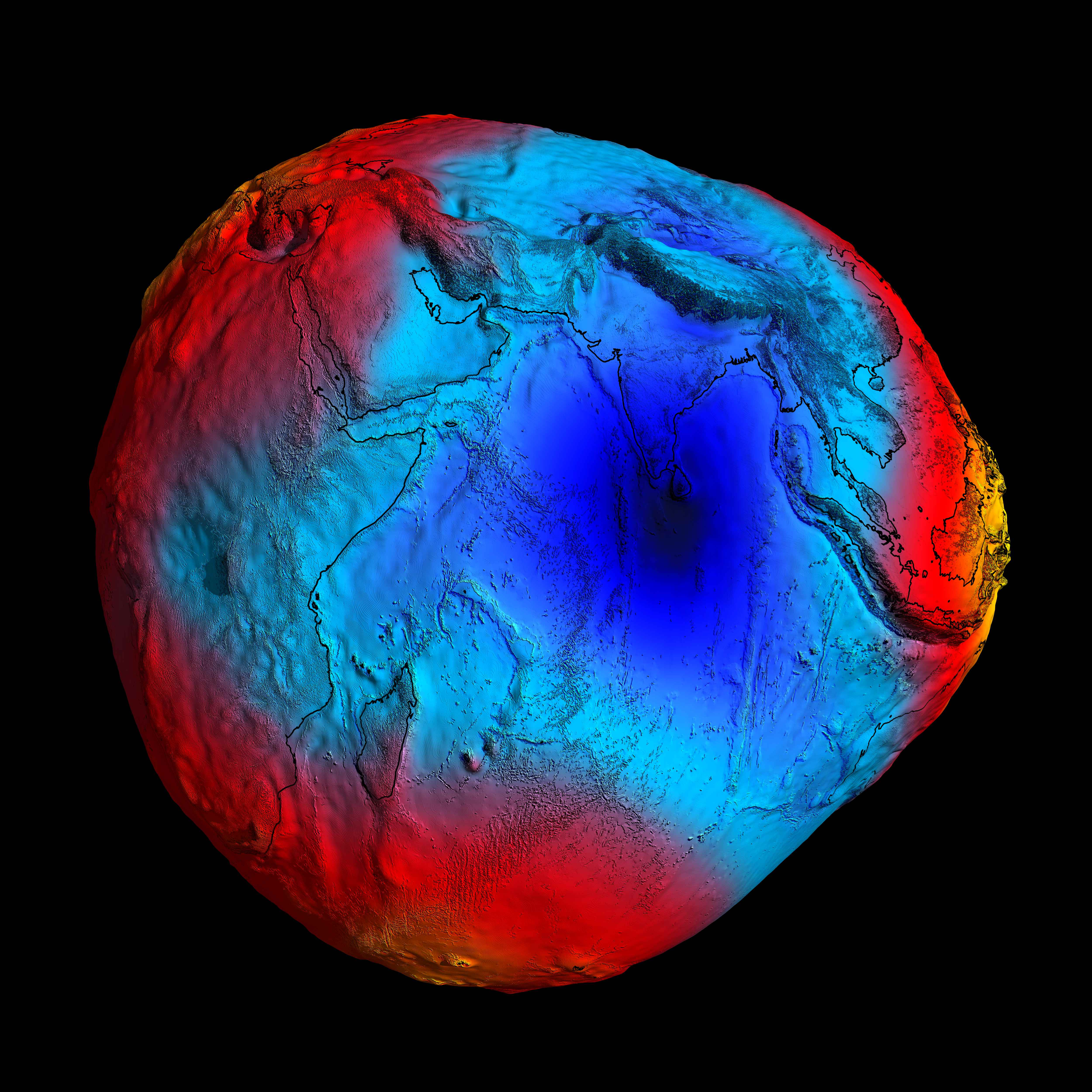
The colors on this map represent deviations in height from an ideal geoid, with blue being lower and yellow/red being higher. The Indian Ocean anomaly is clearly visible, in dark blue.
Seventy-five years after the anomaly's discovery, scientists have finally figured out why sea levels are so much lower here.
The Indian Ocean is home to the world’s largest gravity anomaly. It was first discovered in 1948, but explained only in May of this year. Indian scientists say it was caused by fragments of the ancient Tethys Ocean floor.
Dear Indian Ocean, please don’t take offense, but: Why is your gravity hole so big?
That question had been baffling scientists ever since the hole was discovered back in 1948.
Now a team from the Indian Institute of Science (IISc) thinks they have found the answer:
The “hole” in the Indian Ocean is caused by fragments from the sunken floor of another, much older ocean.
In a mysterious part of the Indian Ocean, the pull of gravity is much weaker than anywhere else on Earth.
This gravity hole, the world’s largest (and deepest) gravitational anomaly, is officially known as the Indian Ocean Geoid Low (IOGL).
(A geoid is a theoretical model of sea levels worldwide, with its irregularities corresponding to variations in the Earth’s gravity.)
F.A. Vening Meinesz demonstrating the operation of his gravimetric device, nicknamed the “Golden Calf.” (Credit: Utrecht University Archive / Museum, CC BY-SA 3.0)
There’s nothing mysterious per se about gravitational variation, which corresponds to differences in the density of the subsurface (and submarine) layers of rock.
What was unexplained, was the size and amplitude of the anomaly in the Indian Ocean.
More air than water
The gravity hole is centered about 1,200 km (750 mi) southwest of Kanyakumari (a.k.a. Cape Comorin), the southernmost tip of the Indian subcontinent.
The circular depression in the ocean has an area of about 3 million sq km (1.2 million sq mi), which is almost the size of India itself.
Due to lower local gravity, the sea level in the IOGL is up to 106 m (348 ft) lower than the global average.
That adds up to a huge volume of air where there should be water. A back of the envelope calculation suggests that, due to the anomaly, about 100 cubic km (25 cubic miles) of water is being displaced.
The anomaly was discovered by Felix Andries Vening Meinesz, a Dutch geophysicist who had invented a device to measure gravity at sea.
(It was nicknamed the “Golden Calf,” because of its color and because sailors on submarines carrying the instrument had to remain motionless in their bunk during measurements, a nuisance for which they received extra pay.)
As a pioneer of submarine gravimetry, Vening Meinesz spent much of his career roaming the oceans in submarines and research vessels.
He discovered several anomalies in Earth’s gravitational field, which he attributed to plate tectonics, none larger or stronger than the one in the Indian Ocean.
Gravimetrical-Geological Map from 1935 of the East Indian Archipelago by Vening Meinesz, et al. This map may be the first to hint at the correlation between gravity and bathymetry.
(Credit: NOAA Central Library Historical Collection / Public domain)
The eminent Dutchman — one of his research fellows was the geologist B.G. Escher, the brother of the graphic artist M.C. Escher — was thinking in the right direction, but his era lacked the computing power to pinpoint a more proximate cause.
The actual cause of the IOGL remained unknown until last May, when the journal Geophysical Research Letters published a study by IISc researchers.
Starting the clock 140 million years ago, the IISc team ran various simulations through a supercomputer to explore how tectonic and volcanic forces shaped the world as we know it.
The models that produced a gravity hole closely resembling the actual IOGL all had one thing in common: low-density magma plumes rising up to displace higher-density material, weakening the area’s gravity.
How it all went down
Here’s the likely scenario: Around 120 million years ago, the Indian plate broke off from the supercontinent of Gondwana, and went on a collision course with the Eurasian plate.
That collision would eventually give rise to the Himalaya mountains.
But before it got there, the Indian plate passed over the Tethys plate, closing up the ancient ocean of that name.
Image produced in 2011 by the European Space Agency’s Gravity field and Ocean Circulation Explorer (GOCE) satellite, the most accurate map of the Earth’s geoid produced until then.
As fragments of that plate — so-called “Tethyan slabs” — were shoved deeper into Earth’s mantle, they displaced some of the material trapped in what is known as the “African blob,” a continent-sized bubble of magma about 1000 km (600 miles) under East Africa.
Some 20 million years ago, that relatively light substance rose toward the surface in plumes.
Together with the mantle structure near the geoid low, those plumes are responsible for the gravitational anomaly off India’s southern tip, the IISc team writes.
While the researchers were able to stick an estimate on the age of the geoid low, it’s hard to predict when or if it will ever shift or disappear.
Flying fish can make powerful, self-propelled leaps out of water into
air, where their long, wing-like fins enable gliding flight for
considerable distances.
It appears these Flying Fish are in a no win
situation, picked off above the surface by Frigatebird's and devoured
underwater by the Dorado.
 This stunning image by amateur photographer Nima Sarikhani just won the Wildlife Photographer of the Year People's Choice Award.
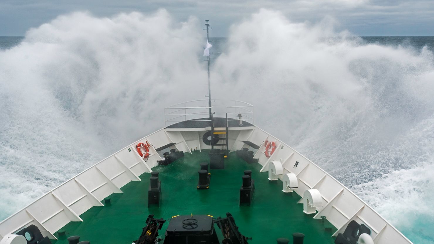
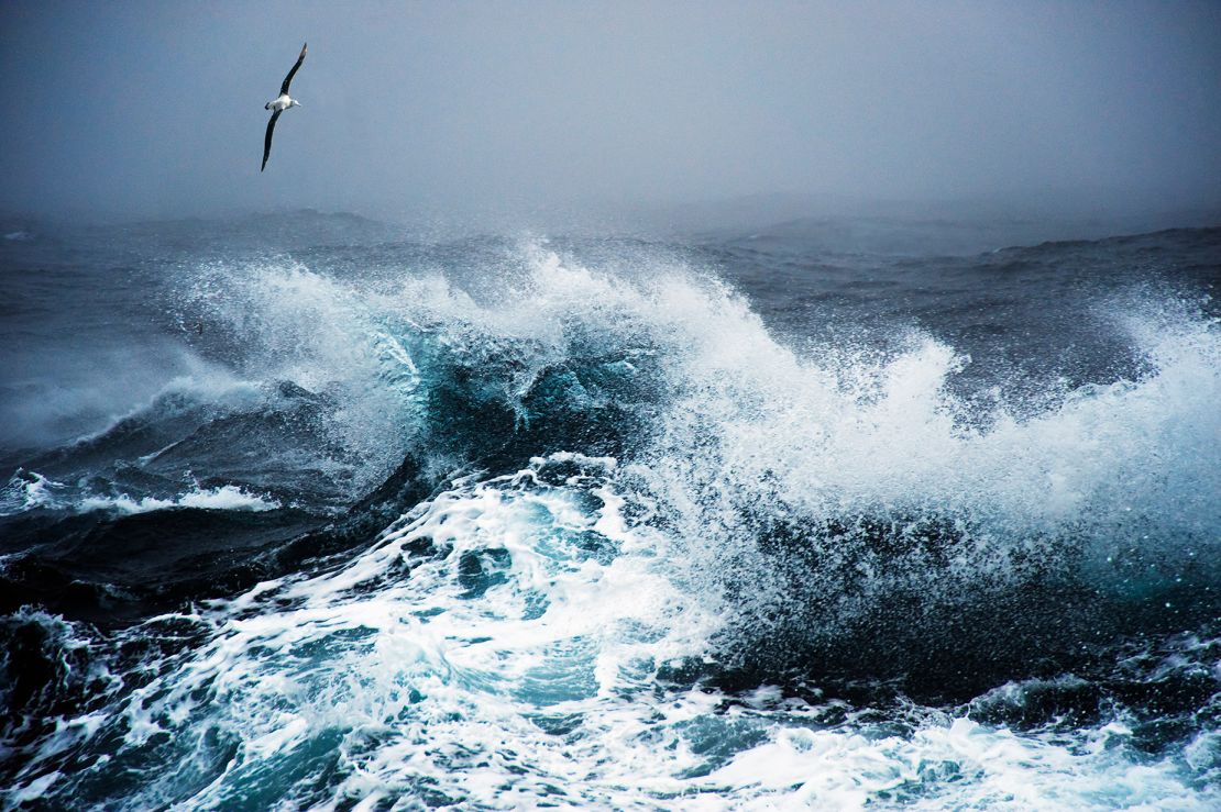

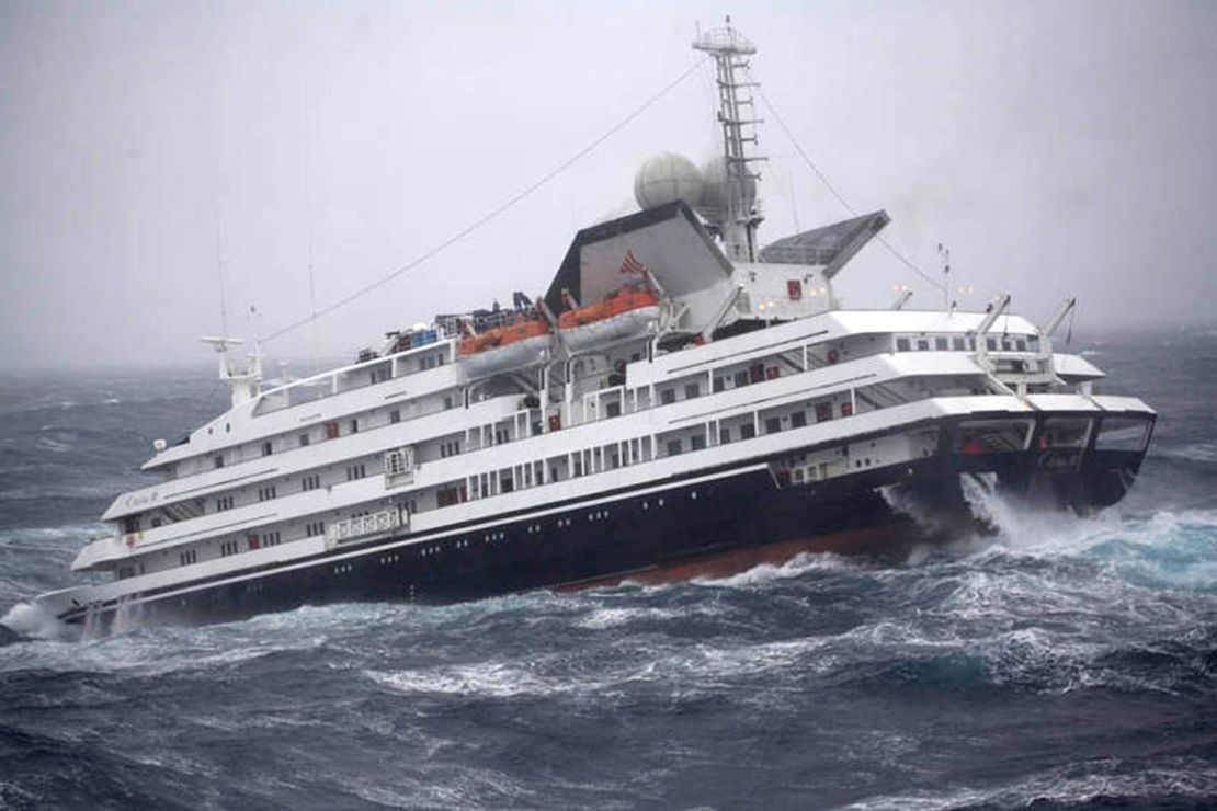
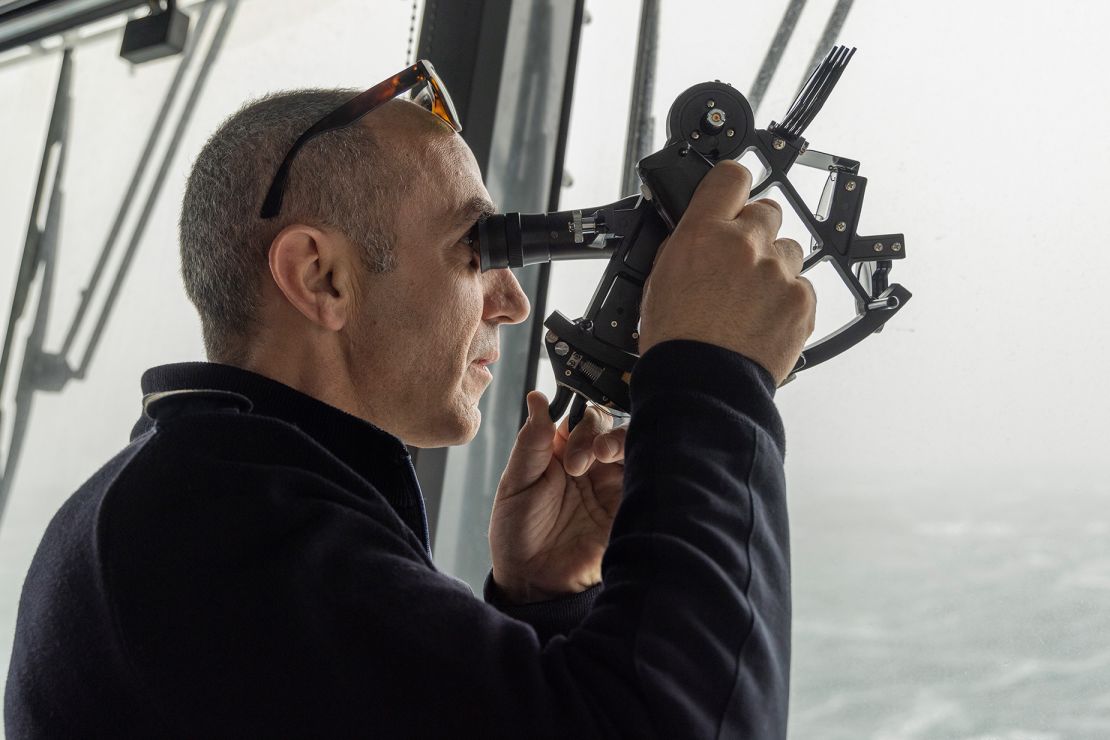

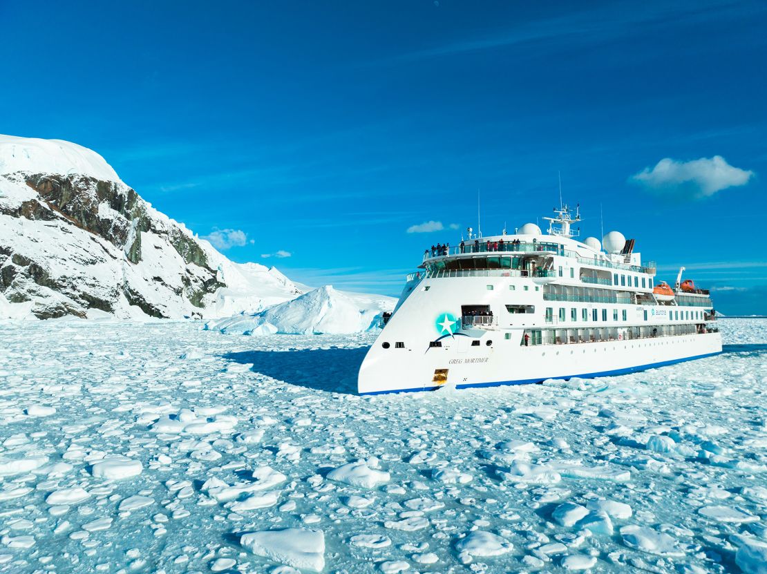
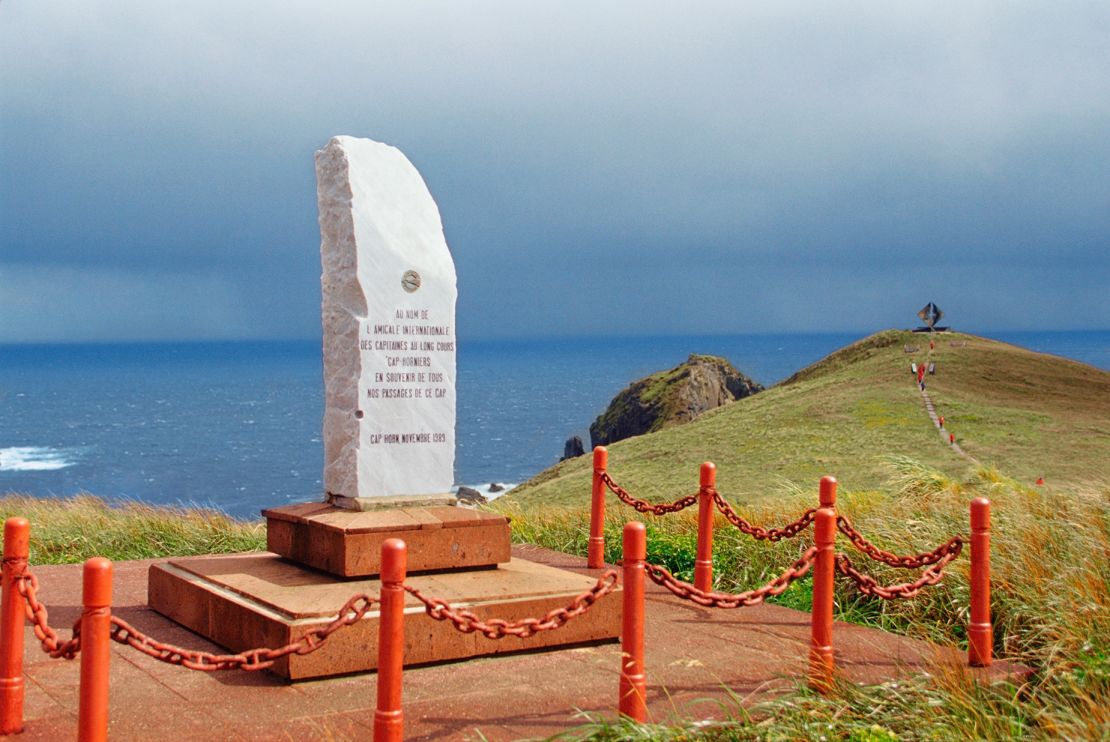
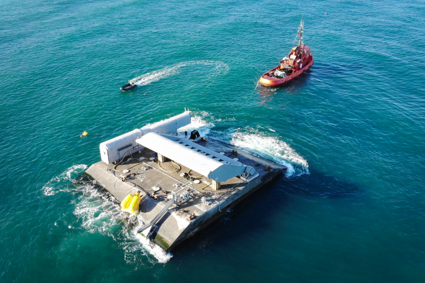

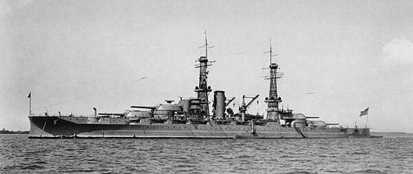
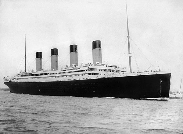
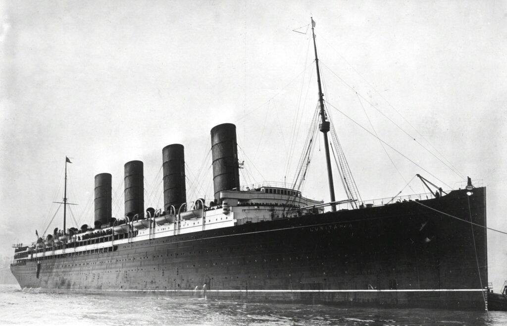

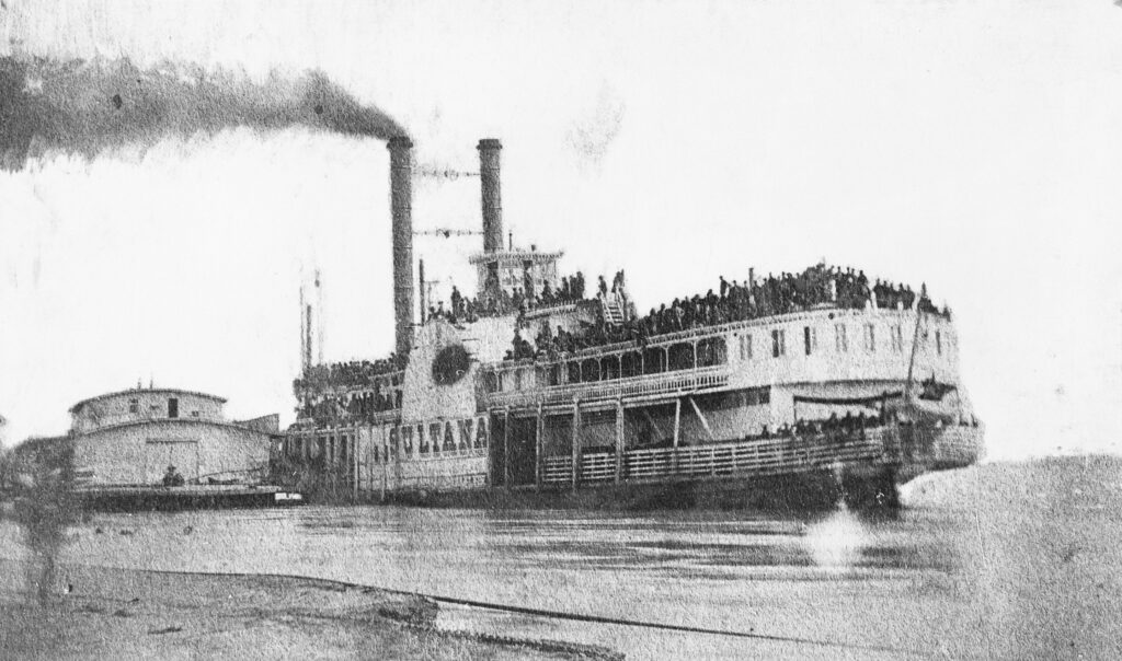
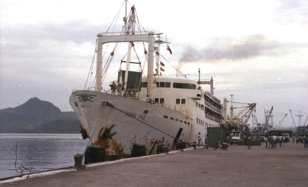
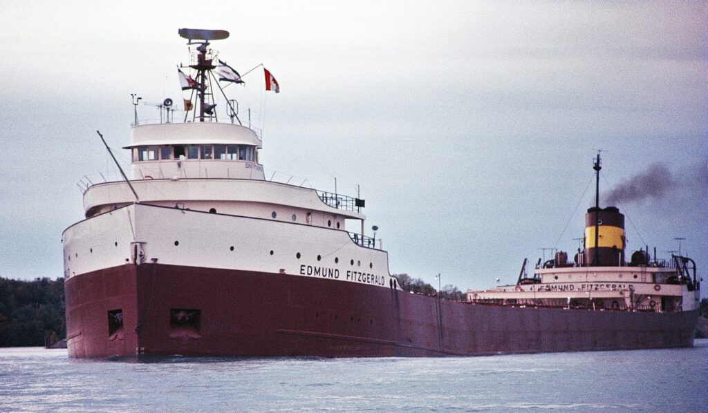
 image: getty images


