Saturday, March 30, 2024

What is a perigean spring tide?


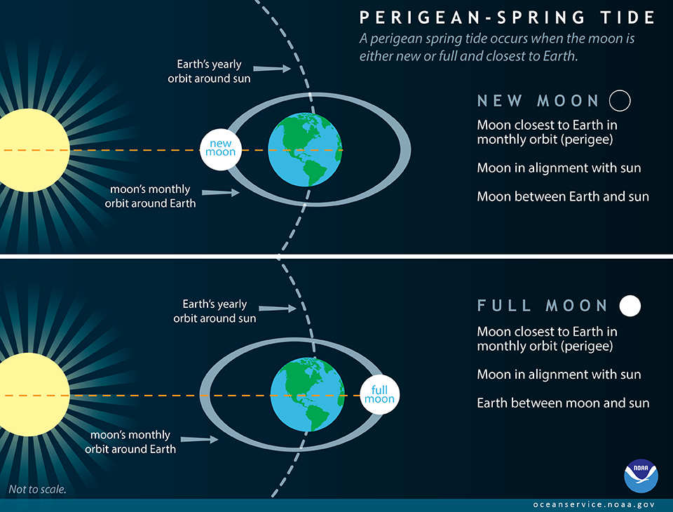
A perigean spring tide occurs when the moon is either new or full and closest to Earth. 
 
From NOAA
 
Often between 6-8 times a year, the new or full moon coincides closely in time with the perigee of the moon — the point when the moon is closest to the Earth.
These occurrences are often called 'perigean spring tides.'
High tides during perigean spring tides can be significantly higher than during other times of the year.

In order to understand the phenomenon called a 'perigean spring tide,' you first have to know that the gravitational pull of the moon and the sun cause tides.
Tides are actually long-period waves that roll around the planet as the ocean is 'pulled' back and forth as the moon and the sun interact with the Earth in their monthly and yearly orbits.

The next thing you need to know is that the moon follows an elliptical path around the Earth in its monthly orbit, and the Earth follows an elliptical path in its yearly orbit around the sun.
This means that, at times, the moon and the sun are closer to Earth.
At other times, they are farther away.
What happens when the moon and the sun are close to the Earth? You guessed it: the gravitational pull they exert is stronger, resulting in slightly higher tides.

While both the moon and the sun influence tides, the moon plays a much larger role because it is so close to the Earth.
Its gravitational pull is about twice as strong as that of the sun.
Now consider these two cases: 

The Effect of a Full or New Moon


During full or new moons — which occur when the Earth, sun, and moon are nearly in alignment — average tidal ranges are slightly larger.
This occurs twice each lunar month (about 29.5 days on average).
The moon appears new (dark) when it is between the Earth and the sun.
The moon appears full when the Earth is between the moon and the sun.
In both cases, the gravitational pull of the sun is ‘added’ to the gravitational pull of the moon on Earth, causing the oceans to bulge a bit more than usual.
This means that high tides are higher and low tides are lower than average.
These are called 'spring tides.'


NOAA's High Tide Bulletin and Flooding Reports

There are many factors that cause the tides to be higher than what is "normally" seen from day to day.
Our monthly bulletin tells you when you may experience higher than normal high tides where you live.
We also publish annual high tide flooding reports that present a broad outlook of what to expect for a given year in terms of high tide flooding, as well as a summary of high tide flooding events for the previous calendar year. 

The Effect of Perigee

Once about every 28 days, the moon reaches a 'perigee,' its closest point of approach to the Earth.
This is the point at which the gravitational pull of the moon is strongest.
During these periods there will be an increase in the average range of tides.
Conversely, about 14 days following the perigee, the moon reaches an ‘apogee’, its furthest point of approach to the Earth.
This is the point at which the gravitation pull of the moon is weakest.
During these periods there will be a decrease in the average range of tides.

What happens when a full or new moon coincides with perigee? 

Full or New Moon + Perigee

Typically between 6-8 times each year, the new or full moon coincides closely in time with the perigee of the moon — the point when the moon is closest to the Earth.
These occurrences are often called 'perigean spring tides.' 
The difference between perigean spring tides and spring tides that occur closer to the moon’s apogee are location dependent and significantly influenced by tidal range, but can be quite large.
It is not uncommon for high tides during a perigean spring tide to be more than a foot higher than high tides during ‘apogean spring tides’.
In places like Anchorage, Alaska, which has a tidal range over 30 feet, the difference between spring tides can be 3 feet or more at high tide!

It's also important to note that other factors influence the height of the tide as well.
Seasonal effects on mean water level and the tide, like higher water level due to the thermal expansion of warmer water, can sometimes mean that some of the highest tides of the year are not perigean spring tides.

Perigean Spring Tides and Coastal Flooding

Coastal flooding doesn't always occur whenever there is a perigean spring tide.
However, perigean spring tides combined with seasonal changes in the tide and mean sea level may cause minor coastal flooding in some low-lying areas, often referred to as “high tide flooding” or “nuisance flooding”.
Major coastal flooding typically occurs in response to strong onshore winds and barometric pressure changes from a coastal storm.
If a storm strikes during a perigean spring tide, flooding could be significantly worse than it otherwise would have been.
In some instances, perigean spring tides have coincided with a shift in offshore ocean circulation patterns and large scale shifts in wind that have resulted in unexpected coastal flooding.
It is expected that occurrences of minor high tide flooding at the times of perigean spring tides will increase even more as sea level rises relative to the land.
NOAA’s tide and tidal current predictions take into account astronomical considerations due to the position of the moon and the sun.

Friday, March 29, 2024

Flight MH370 is still missing after ten years – forensic experts explain what we know and why we haven’t found the plane

An image from 17 March 2014 showing Filipino artists with a depiction of flight MH370, created to express solidarity with the passengers.
AMIEL MENESES / EPA IMAGES

From The Conversation by Jamie Pringle / Alastair Ruffell  / Ruth Morgan

It has been ten years since Malaysian airlines flight MH370, carrying 239 passengers and crew on board, disappeared less than one hour after taking off from Kuala Lumpur on 8 March 2014.
It has become one of the great unsolved mysteries of modern times and is a puzzle that has remained resolutely unsolved.

Theories abound on the flight’s disappearance and current location of the wreckage.
Unusually, all communications aboard the plane were switched off shortly after take-off.

Intermittent satellite location information subsequently suggested it was flown south on a very different flight path than expected, to a remote and deep ocean area of the Southern Indian Ocean before contact was lost.

When actively searching for MH370, sophisticated international surveillance aircraft initially conducted over 300 flights to visually look for plane debris on the surface.
Then surface and submersible vehicles conducted further surveys, searching over 120,000 sq km of ocean before ending the search in 2017.

The effort to find MH370 became one of the most expensive aviation searches in history.
These surveys used both sonar (active acoustic instruments to image the sea floor to locate the aircraft), and also listening devices to pick up the aircraft’s flight data recorder.

Confirmed MH370 plane debris were found on Reunion Island in July 2015, and off the coast of Mozambique in February 2016, which was consistent with what we know about ocean currents.
In 2018, OceanInfinity, a private exploration company, also searched 25,000 sq km but without success.

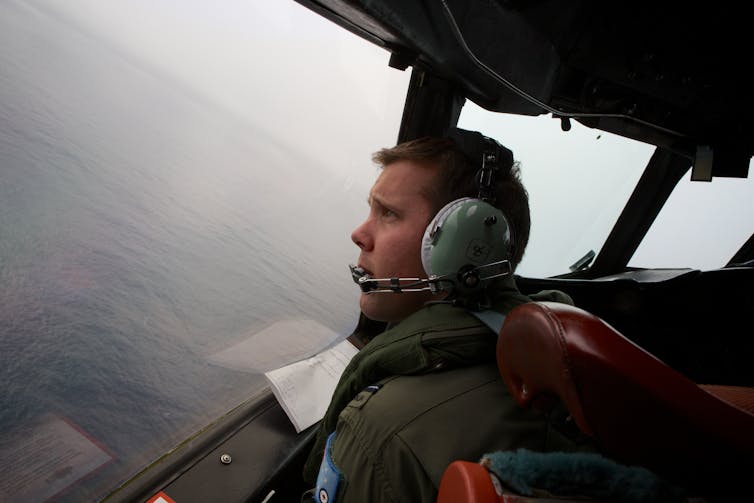
A Royal Australian Air Force flying officer looks out for signs of MH370 during a search in bad weather on 24 March 2014.

Since then, a mixture of highly trained experts and members of the public have sought to assist the search.
These efforts have varied from simple to really advanced data analysis.
They have attempted to map the locations and timings of plane debris, and other maritime debris, as well as model drift currents.
In doing so, they are attempting to reconstruct where these may have originated from, which is no small task.

Analysis of the MH370 flight path has been pieced together from two different types of radar – primary and secondary – as well as the intermittent data “pings” from the plane to the Inmarsat satellite.
The results suggest that it diverted south from its intended flight path.

Another technique called weak signal propagation (WSPR data (a way of using radio emission to track objects such as planes), had defined a specific but very large search area, some of which has already been searched.

Available hydroacoustic data (based on the way sound propagates in water) of the sea floor has also been analysed.
However, only a relatively small area was covered and the marine sea floor in this region can be very rugged.
There are deep submarine canyons that can hide objects much bigger than a plane.

Lessons from studying past flight disasters also informed the search.
These included the 2009 Yemenia plane crash in the Indian Ocean.

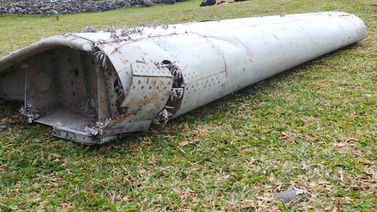
A flaperon from MH370 washed up on Reunion island in the Indian Ocean.
ZINFOS974 / EPA IMAGES
 
Recovery operation

For inland or coastal water searches, a phased investigation strategy is suggested as best practice, where investigators look to identify water depths, major current strengths and directions, together with pre-existing site information, before specialist search teams are employed using methods, equipment configurations and personnel that have all been accredited.

However this reliance on technology can be problematic.
Even in small waterways, the presence of vegetation in the search area or a target buried by sediment can make these searches difficult.

Much of the Southern Indian Ocean sea floor is rugged and relatively unmapped, with water depths of up to 7.4km.
It’s away from regular shipping lanes and commercial flight patterns, with few fishing boats, no significant land masses and some of the worst winds and weather in the world.
These factors also make it a very challenging area to search. 

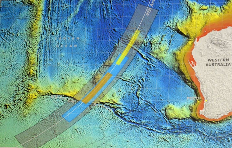
Parts of the seafloor in the area where MH370 went missing are extremely rugged.
ALAN PORRITT / EPA IMAGES


In deep water (more than 2km to 3km) deploying sonar is cumbersome and prohibitively expensive.
It also takes a long time to generate data.
A major challenge for scanning technologies is achieving accuracy at these kinds of depths due to the scattering of the signal caused by uneven, especially rocky substrates on the sea floor.

The development of more advanced autonomous submersible vehicles may hold the key to finding MH370 in the Southern Indian Ocean, along with post-processing of raw data which can clarify what can be attributed to rocks as well as sea-floor hummocks and pockets.


This can distinguish between the sea floor and the objects being searched for.
However, the area where MH370 disappeared is vast, meaning future searches will remain just as challenging as when the plane first went missing in 2014.

Links :

Thursday, March 28, 2024

National security leaders worry about U.S. failure to ratify Law of the Sea treaty


From CBS News by Bill Whitaker , Aliza Chasan , Heather Abbott, LaCrai Scott

Hundreds of former national security, military and political leaders are calling on the Senate to ratify the United Nations' Law of the Sea, warning last week in a letter to lawmakers that China is taking advantage of America's absence from the treaty.

Countries that ratified the Law of the Sea treaty are now rushing to stake claims on the international seabed for deep sea mining.
At stake are trillions of dollars worth of strategic minerals strewn on the ocean floor, essential for the next generation of electronics.
China has five exploration sites, 90,000 square miles –the most of any country.
The U.S. has none.
It is blocked from the race because of the Senate's refusal to ratify the Law of the Sea.

"We are not only not at the table, but we're off the field," lawyer John Bellinger, who was a legal adviser to former President George W. Bush, said.
"The United States probably has got the most to gain of any country in the world if it were party to the Law of the Sea Convention, and conversely, we actually probably have the most to lose by not being part of it." 
 

What can be gained from the Law of the Sea Treaty and deep sea mining

Vast quantities of minerals are scattered across the ocean floor.
Researchers have found potato-sized lumps of rock, known as nodules, filled with cobalt, nickel, manganese and copper — some of the most valuable metals on earth.
They're vital for everything from electric cars to defense systems.

To avoid a free-for-all, 168 countries, including China, have signed onto the United Nations Law of the Sea treaty, which divides the international seabed.

The United Nations adopted the Convention on the Law of the Sea (UNCLOS) in 1982.
Often called the constitution for the ocean, the treaty codifies existing international law on freedom of navigation.
It also created the International Seabed Authority, which regulates the new deep sea mining industry.

President Bill Clinton signed the treaty, but it was dead on arrival in the Senate who refused to ratify the treaty, saying it undercut American sovereignty.

Why the U.S. won't ratify the treaty

Despite broad bipartisan support — including efforts by five presidents — the treaty has hit a wall in the Senate year after year.

Bellinger, who was a legal adviser to former President George W. Bush, testified in favor of the treaty at Senate hearings in 2012.
While Bush was not a fan of U.N. treaties, Bellinger said Bush supported the Law of the Sea Treaty, not only for codifying access to the ocean floor, but also because the treaty guarantees the freedom of navigation around the world that's so important to the Navy.

In 2012 – the last time the Senate held hearings on the treaty – the Law of the Sea had the support of the president through the intelligence community, big oil, major business groups and the U.S.
military, Bellinger said.
He thought it was a slam dunk.

It failed.

The conservative Heritage Foundation convinced 34 Republican senators to vote against the treaty, saying it would subjugate the U.S. to the U.N.
"The opposition was not on national security reasons or on business reasons," Bellinger said.
"It to me seemed just a reflexive ideological opposition to joining the treaty."

Heritage Foundation senior policy analyst Steven Groves also testified in 2012.
He said the U.S. didn't need anyone's permission to mine the seabed.
His views haven't changed.
"What businessman in their right mind said, 'I'm going to invest tens of billions of dollars into a company that I will then have to go…and ask permission from an international organization to engage in deep seabed mining,'" Groves said.
He insists American companies are staying away not because the U.S. hasn't ratified the treaty, but because deep sea mining isn't viable.
"If China wants to go and think that it's economically feasible to drag those nodules up to the surface and process them, let them do it" Groves said.
"The United States has decided to stay out of the game. The one U.S. company that had rights to the deep seabed got out of the game, that's Lockheed Martin."

But Lockheed Martin has not entirely quit.
The defense giant had rights to four Pacific seabed sites; it sold two and is holding onto two in case the treaty passes.
But Lockheed told "60 Minutes" that if the U.S. doesn't ratify the treaty, it can't dive in.

Ambassador John Negroponte, a former director of National Intelligence in the Bush administration, said the Heritage Foundation is still standing in the way.
"What Heritage is saying is 'we don't even want to give 'em a chance.
We have—we know the answer already.
And I, you know, I think that's sort of hypothetical thinking," Negroponte said.
"The pragmatic approach would be to say, 'OK, let us have access and see what happens.'"
 
How the U.S.'s failure to ratify the treaty could hurt American business, empower China's economy

With seabed mining starting as early as next year, China is in place to dominate it.
China already controls a near monopoly of critical minerals on land.
Now it wants to extend that control to the ocean floor.
If it succeeds, there are national security fears the U.S. could end up even more dependent on China for these critical minerals.

"If they end up being the largest producer and we're not producing at all from the ocean…I think then that might place us in a difficult economic position," Negroponte said.
In the years since 2012, China has become more assertive on the international scene, especially in the South China Sea, Negroponte said.
"And then with respect to deep seabed mining, they're eating our lunch," he said.

Unless America ratifies the treaty, it won't have a say in drafting environmental rules for seabed mining that are underway now.
With the U.S. absent, China is the heavyweight in the room at the International Seabed Authority.

"We are conceding," Negroponte said.
"If we're not at the table and we're not members of the Seabed Authority, we're not going to have a voice in writing the environmental guidelines for deep seabed mining.
Well, who would you prefer to see writing those guidelines? The People's Republic of China or the United States of America?"

Military concerns over the U.S. failure to ratify the treaty

Concerns over China's expansive powers in the deep sea are about more than mining.
Many national security, military and political leaders are warning that China is taking advantage of America's absence from the treaty to pursue overall naval supremacy.

Thomas Shugart, a former U.S. Navy submarine warfare officer and a senior fellow at the Center for a New American Security, said being outside the treaty undercuts American credibility while China is laser-focused on building its maritime power.
Shugart said China's deep sea miners have a second mission: collecting information for the Chinese military.

"If you're going to find submarines in the ocean, you need to know what the bottom looks like.
You need to know what the temperature is.
You need to know what the salinity is," Shugart said.
"If China is using civilian vessels to sort of on the sly do those surveys, then that could improve their ability to find U.S. and allied submarines over time as they better understand that undersea environment."

Shugart also said China is flexing its maritime muscle by claiming the South China Sea as its private ocean.

The country has challenged the treaty's navigation laws that ensure safe passage by harassing passing ships, including the U.S. Navy.
China has fired water cannons at its neighbors, caused collisions and even flashed a military-grade laser at ships.

For Groves, of the Heritage Foundation, that's why the treaty is meaningless.
"It's China who is a party to the treaty who doesn't obey the rules of the road," Groves said.
"They're the ones getting into near collisions with U.S. vessels in the South China Sea. The United States respects and adheres to international law. It is the Chinese who are the scofflaws here. And the idea that the U.S. joining the treaty would somehow change that Chinese behavior has no basis in reality."

But Shugart said that when the U.S. calls out China for violating the law, China responds, "well you're not a signatory… so what do you have to say about it?"
"We are in a messaging contest and an effort to win hearts and minds all over the world against what is clearly our greatest strategic competitor," Shugart said.

In Washington, Negroponte's group continues to lobby the Republican holdouts in the Senate as China forges ahead.
When "60 Minutes" reached out to those senators who torpedoed the treaty in 2012, their opposition today was as strong as ever.

"It just doesn't make sense to a conservative to say, 'these minerals that are in the deep seabed are so important to the United States, we are done without those, let's put an international bureaucracy in charge of getting us access to them,'" Groves said.

Sen. Mike Lee, a Republican from Utah who opposed the treaty in 2012, maintains that there's nothing in the Law of the Sea that advances America's interests.
"The U.S. needs to reject the constant impulse to cede sovereignty by allowing unelected and unaccountable global bureaucrats [to] regulate away new frontiers," Lee told "60 Minutes" in a recent statement.
"Ratification today would be a win for the climate lobby and the global elites who feel entitled to govern from the shadows.
I remain opposed to ratification of UNCLOS because the price of admission is a nonstarter."

Links :

Wednesday, March 27, 2024

Antarctic sea ice near historic lows; Arctic ice continues decline

Visualization of Antarctic sea ice on February 20, 2024, when sea ice there hit its lowest annual extent.<br />Earth is seen from the bottom, with the South Pole in the center.<br />The continent is white and has some sea ice surrounding it.<br />The rest of the globe is blue ocean water in this view.

Visualization of Antarctic sea ice on March 14, 2024, when Arctic sea ice hit its maxium extent.<br />Earth is seen from the top down, with the Arctic in the center.<br />Green and white land can be seen above and below it.<br />Open ocean is blue on the left and right sides of the globe.<br />Arctic sea ice extends from Greenland and parts of Canada to Russia.
Sea ice at both of Earth’s poles continued declining in 2024.
Antarctic sea ice reached near-historic lows on Feb.
20 and Arctic sea ice is the 14th lowest on record, NSIDC reports.
However, it’s too soon to know whether recent sea ice lows at the South Pole point to a long-term change rather than a statistical fluctuation.

From NASA by James Riordon

Sea ice at both the top and bottom of the planet continued its decline in 2024.
In the waters around Antarctica, ice coverage shrank to near-historic lows for the third year in a row.
The recurring loss hints at a long-term shift in conditions in the Southern Ocean, likely resulting from global climate change, according to scientists at NASA and the National Snow and Ice Data Center.
Meanwhile, the 46-year trend of shrinking and thinning ice in the Arctic Ocean shows no sign of reversing.

“Sea ice acts like a buffer between the ocean and the atmosphere,” said ice scientist Linette Boisvert of NASA’s Goddard Space Flight Center in Greenbelt, Maryland.
“Sea ice prevents much of the exchange of heat and moisture from the relatively warm ocean to the atmosphere above it.”

Less ice coverage allows the ocean to warm the atmosphere over the poles, leading to more ice melting in a vicious cycle of rising temperatures. 
Historically, the area of sea ice surrounding the Antarctic continent has fluctuated dramatically from year to year while averages over decades have been relatively stable.
In recent years, though, sea ice cover around Antarctica has plummeted.
 
On Feb. 20, 2024, Antarctic sea ice officially reached its minimum extent for the year.
This cycle of growth and melting occurs every year, with the ice reaching its smallest size during the Southern Hemisphere’s summer.
According to the National Snow and Ice Data Center, this marks the second-lowest sea ice extent recorded by satellites, reflecting a trend of declining coverage over time.
Credit: NASA’s Goddard Space Flight Center/Scientific Visualization Studio
Download this video in HD formats from https://svs.gsfc.nasa.gov/14538.

“In 2016, we saw what some people are calling a regime shift,” said sea ice scientist Walt Meier of the National Snow and Ice Data Center at the University of Colorado, Boulder.
“The Antarctic sea ice coverage dropped and has largely remained lower than normal.
Over the past seven years, we’ve had three record lows.”

This year, Antarctic sea ice reached its lowest annual extent on Feb.
20 with a total of 768,000 square miles (1.99 million square kilometers).
That’s 30% below the 1981 to 2010 end-of-summer average.
The difference in ice cover spans an area about the size of Texas.
Sea ice extent is defined as the total area of the ocean in which the ice cover fraction is at least 15%.
This year’s minimum is tied with February 2022 for the second lowest ice coverage around the Antarctic and close to the 2023 all-time low of 691,000 square miles (1.79 million square kilometers).
With the latest ice retreat, this year marks the lowest three-year average for ice coverage observed around the Antarctic continent across more than four decades.

The changes were observed in data collected with microwave sensors aboard the Nimbus-7 satellite, jointly operated by NASA and the National Oceanic and Atmospheric Administration (NOAA), along with satellites in the Defense Meteorological Satellite Program.

Meanwhile, at the other end of the planet, the maximum winter ice coverage in the Arctic Ocean is consistent with an ongoing 46-year decline.
Satellite images reveal that the total area of the Arctic Ocean covered in sea ice reached 6 million square miles (15.65 million square kilometers) on March 14.
That’s 247,000 square miles (640,000 square kilometers) less ice than the average between 1981 and 2010.
Overall, the maximum winter ice coverage in the Arctic has shrunk by an area equivalent to the size of Alaska since 1979.

This year’s Arctic ice maximum is the 14th lowest on record.
Complex weather patterns make it difficult to predict what will happen in any given year.


The Arctic Ocean sea ice reached its annual maximum on March 14, continuing the long-term decline in ice at the poles.
Chart by Lauren Dauphin/NASA Earth Observatory, using data from the National Snow and Ice Data Center. 
 
This chart shows the daily sea ice extent through early March 2024 (red) compared to the 2023 record low (orange) and the average extent from 1981 to 2010 (blue).
The recent minimum tied with February 2022 for the second-lowest ice coverage around Antarctica and was close to the 2023 all-time low of 1.79 million square kilometers (691,000 square miles).
With the latest ice retreat, this year marked the lowest three-year average for ice coverage ever observed around the Antarctic continent.
 
Shrinking ice makes Earth more susceptible to solar heating.
“The sea ice and the snow on top of it are very reflective,” Boisvert said.
“In the summer, if we have more sea ice, it reflects the Sun’s radiation and helps keep the planet cooler.”

On the other hand, the exposed ocean is darker and readily absorbs solar radiation, capturing and retaining that energy and ultimately contributing to warming in the planet’s oceans and atmosphere.

Sea ice around the poles is more susceptible to the weather than it was a dozen years ago.
Ice thickness measurements collected with laser altimeters aboard NASA’s ICESat-2 satellite show that less ice has managed to stick around through the warmer months.
This means new ice must form from scratch each year, rather than building on old ice to make thicker layers.
Thinner ice, in turn, is more prone to melting than multi-year accumulations.

“The thought is that in a couple of decades, we’re going to have these essentially ice-free summers,” Boisvert said, with ice coverage reduced below 400,000 square miles (1 million square kilometers) and most of the Arctic Ocean exposed to the Sun’s warming glare.

It’s too soon to know whether recent sea ice lows at the South Pole point to a long-term change rather than a statistical fluctuation, but Meier believes long term declines are inevitable.

“It’s only a matter of time,” he said.
“After six, seven, eight years, it’s starting to look like maybe it’s happening.
It’s just a question of whether there’s enough data to say for sure.” 
 
Links :

Tuesday, March 26, 2024

Triton’s new personal sub is much more than a superyacht yoy


AVA on a Bahamian demo dive, exploring the wonder under the ocean.
AVA (Advanced Versatile Acrylics).
It has arc seating for -nine- persons to a depth of 660 feet (about 4x maximum scuba depth).
Photo by Nick Verola

From Forbes by Kathleen Turner 
 
Fun? Absolutely.
Beautiful? From both technical and design standpoints, a resounding yes.
Safe? No question.
Useful? Let me count the ways.
Triton’s new sub is a crowd-pleaser that can seat up to eight passengers plus pilot, in a stylish, relaxed, ultra-safe bubble that gives guests a phenomenal view of the undersea world.

Triton recently sent an invite to join CEO Patrick Lahey and eight guests on a demo dive in the Bahamas.
It was, in a word, extraordinary.
Details? Read on.

Meeting AVA

Arriving at the FBO in Freeport after a quick hop from Nassau, the other guests and I jumped onto a tender headed for the offshore supply ship, Go America.
We could see the bright yellow sub on her stern as we sped out across the aquamarine waves.
The group was a mixture, some with many sub dives under their belt, along with a few neophytes, but we were all were excited about meeting AVA.


AVA on board Go America, readying for the dive.
photo by K L Turner

As we stepped from the tender to the ship, AVA greeted us, nonchalantly hooked up to the 8-ton crane.
Her bright yellow cape wrapping a large ellipse of unbelievably clear acrylic, AVA flashed her mechanical smile as she awaited her swim.
A stunning creature, shiny yellow fenders defined by crisp black accents and flawless elliptical acrylic capsule, revealed her spacious interior with an arc of seating for nine.

AVA is Triton’s new submersible model, the 660/9, meaning she can dive to a depth of 660 feet with seating for nine.
AVA, for Advanced Versatile Acrylics, is the first sub with a free-form acrylic pressure hull.
In a world of orbs, AVA is an egg offering a range of creative uses for 6,300 liters of air conditioned, beautifully lit interior space with surround sound.
Think undersea luxury with cocktails, intimate coral reef dinners, distinctive weddings, VIP casinos, or perhaps even the discovery of a new ocean species.
It has happened.


A 3/4 profile of Triton's 9-person submersible, AVA, prior to showing us the Bahamas from a new perspective beneath the waterline
photo by K L Turner 

Down The Hatch

Our shoes off and cameras ready, the crane lifted AVA’s compact shape into the water as we tendered out to make an easy climb through the 23.6-inch hatch.
We chose seats, with the captain centered, and all of us wide-eyed, gap-mouthed passengers in a gentle curve.


Closing the hatch on Triton's 9 person sub, AVA, in preparation for the dive.
photo by K L Turner 

Chris, our pilot, was undergoing training, with Triton CEO Patrick Lahey to his right, and another experienced pilot to his left.
Both pilots from the Scenic Eclipse luxury adventure cruise line were working through the commissioning process in anticipation of offering tours to cruise guests.

Confident in their abilities, Lahey explained, “Both very experienced pilots, they’ve done hundreds and hundreds of dives on the sub they already have on the Scenic Eclipse I. This sub is going on the Scenic Eclipse II.”
Lahey also lightheartedly noted that both he and Chris were just “two guys from Ottawa,” an unlikely origin for their respective careers.


Patrick Lahey, Triton CEO, and Scenic Eclipse pilot Chris preparing on our way down to the sea floor
photo by K L Turner 

Chris, carefully explaining the safety features on board, noted, “We always dive in positive buoyancy.
The sub will always want to come to the surface on its own.” 
Chris then gave us all the details regarding the multiple safety preparations, adding that the sub had run through all the systems with the DNV, Det Norske Veritas, completing the final step in the certification of a new sub.
It took six months longer than expected, Lahey commented, “Sometimes when you’re doing something unique and creating something extraordinary, it takes a little longer.”

Lahey noted of this training dive, “We are there for them and we support them fully.
The idea is that they should be able to operate and maintain their own craft.
Certainly, there’s nothing on this sub that’s any more complicated than the things that are on their vessel.
This is infinitely simpler than the vessels they live and work on.”


Triton's new 9-person submersible, AVA, from the back looks just as sleek.
photo by K L Turner 

Knowing the extensive testing and certification this sub has undergone, I had no question about our safety.
Shades of James Cameron, Ray Dalio, and Victor Vescovo, we were on our way down.

Chris explained that the noise we were about to hear would come from letting air out of the valves to adjust the thrusters.
A good heads up, the sub was quite silent inside with no background noise when the whoosh of the thrusters sent bubbles up.
Shortly, we were below the waterline, peering into the ocean.


Bubbles up, as Triton sub AVA dives below the surface of Bahamian waters.
photo by K L Turner 

Into The Magic

Softly, silently, save for our own chatter, we gently descended.
That’s where the magic begins.

Lahey introduced us to this world, commenting, “It makes the experience of being in a sub very immersive.
You feel like you can touch things.
There’s no difference between where the acrylic starts and the water begins.”

AVA’s flawlessly clear acrylic is the same refractive index as water, making the surrounding hull miraculously disappear.
The view was wondrous, removing the perception of any barrier between us and the sea.
It truly seemed we could reach out and touch the flora and fauna as we cruised among the parrotfish and undulating sea grass.

Lahey added, “If I see something cool and I point it out to you, you’ll get to see it as well.
That’s part of what makes this elliptical pressure boundary unique,” alluding to AVA’s distinctive benefits.


An overhead shot of Triton sub AVA shows the elliptical pressure boundary that virtually disappears once submerged, owing the same refractive index as water.
 Photo by Nick Verola
 
Cruising The Ocean Floor

Very quiet and very blue, with wondrous forms and figures, the sea floor reached out in front of us as we gracefully hovered just above, navigating the terrain.
At an almost therapeutic speed, forcing us to slow our gaze as we explored the panorama; above, below, far and wide; AVA gave the perception of slowing time as well.

Chris commented, “Everything is in slow motion, as Lahey added, “Cousteau said it best, ‘Speed is the enemy of observation,’ so if you want to look at things, take your time to explore.”
And we did.

Back To The Surface

I could have stayed there for hours, but all too soon, Chris was communicating with Go America to coordinate our position for surfacing.
Lahey noted that radio frequencies and traditional communications systems like VHF radios do not function in a marine operation.

“Once you go under water all radio frequencies are lost, so you don’t have GPS, you don’t have VHF radios,” Lahey explained, “You have to use sound, so that’s why we use sonar for navigating, seeing far beyond our distance.”

So Much To Explore

Triton has provided subs for a variety of research, leisure, and tourism uses, with a perfect record of over 10,000 dives including some to the deepest trenches.
Their subs have played important roles in OceanX, National Geo, and countless discovery dives.
With a planet that is about 70 percent water, there is a world of exploration now open to us.

With a number of models of varying depth ratings and passenger numbers, the subs range in price from $2.5 million to $40 million, with most around $4.75 million.


Triton 9-person sub AVA showing her magical elliptical pressure boundary and sunny, mechanical smile
photo by Nick Verola

It will take some work to bring ocean exploration to the level of space exploration, but with tools like AVA and her fleet of sisters, the time is right, whether for science, leisure, commerce, and beyond, for discovery.
Take a ride.
You will not regret it.
 
Links :

Monday, March 25, 2024

Advancements in satellite technology enhance coastal bathymetry measurements


Summary: A research team from Korea has developed a new model for satellite-derived bathymetry (SDB), which has the potential to revolutionize the way we measure depths in coastal waters.
Utilizing machine learning, this approach aims to overcome the limitations of traditional SDB methods influenced by water clarity and seabed composition.
Their promising work, which could impact marine navigation and environmental monitoring, has been detailed in the Journal of Applied Remote Sensing.


From YTech News by Igor Nowacki

Coastal bathymetry, a critical component of maritime operations and environmental research, has seen a revolutionary advancement through the adoption of satellite imaging techniques.
A Korean research team, including Dr. Tae-ho Kim from Underwater Survey Technology 21 (UST21), has been instrumental in refining these techniques, crafting a model that utilizes machine learning to improve the accuracy of water depth estimations from space.
Their commitment has culminated in an innovative study published in the Journal of Applied Remote Sensing.

Historically, bathymetric data were difficult to amass due to factors such as cost and accessibility.
Traditional methods using shipborne echo sounders faced challenges like adverse weather and limited coverage.
The new model seeks to alleviate these barriers by extracting depth information from satellite images captured by the European Space Agency’s Sentinel-2A/B missions.

In an effort to generate a robust SDB model, the team selected three distinct coastal regions of the Korean Peninsula, each offering unique environmental variables for analysis—Samcheok’s clear waters, Cheonsuman’s turbid conditions, and Hallim’s diverse seabed sediments.
The model was trained using this diverse satellite imagery alongside echo sounder-derived nautical charts, serving as validated reference points.

Machine learning techniques, particularly the application of a random forest algorithm, play a pivotal role in the model’s capacity to adapt to varying coastal environments.
By assessing how light penetrates and reflects off of different marine landscapes, this algorithm allows for more precise depth calculations across a spectrum of coastal conditions.
It promises significant improvements in SDB, a critical tool for marine safety, resource management, and environmental stewardship.

Visualization of global satellite-derived bathymetry from EOMAP.
(Image courtesy: EOMAP)


Industry Background & Market Forecasts

The maritime industry relies heavily on accurate bathymetric data for various applications such as navigation, laying underwater cables, dredging, and environmental protection.
The market for bathymetry has been growing due to advancements in related technologies, including satellite-derived bathymetry, and an increasing interest in marine environments for exploration, tourism, and conservation.
The coastal zone management sector also benefits from precise bathymetric data, facilitating shoreline protection and sustainable exploitation of coastal resources.

Market forecasts suggest a positive trend for the growth of the satellite-based earth observation market, within which SDB is a niche but growing segment.
As countries invest more in coastal management and marine spatial planning, accurate and cost-effective bathymetric data becomes increasingly important.
Satellite-derived bathymetry services are becoming an attractive solution in this scenario, especially for areas where traditional survey methods are not feasible or economically viable.

Geographic location of training areas. Sentinel-2A/B RGB images of (a) Cheonsuman, (b) Hallim, and (c) Samcheok. The blue boxes indicate three additional test areas, different from the training areas. Deokjeok in Yellow Sea, Seongsan in South Sea, and Sokcho in East Sea.

Current Progress in SDB Technology

The milestone achieved by the Korean research team is part of a broader industry effort to leverage machine learning and artificial intelligence (AI) in the realm of earth observation.
Their work aligns with other technological advancements that aim to improve data acquisition and processing capabilities in environments where traditional methods are limited.
The accuracy of SDB methods has been steadily improving, resulting in increased resolution of the seabed mapping and extended capabilities in deeper waters.

Major players in the satellite imagery and remote sensing field continue to launch more sophisticated satellites capable of providing higher resolution images, which in turn contribute to the refinement of SDB methods.
In addition to the European Space Agency’s contributions with the Sentinel missions, other organizations and companies are also deploying satellites which could further enhance the capabilities of SDB.

Challenges Facing the Industry

Despite advancements, there are several challenges that remain within the industry.
The quality and accuracy of SDB can still be limited by factors such as water clarity, surface waves, seabed reflectivity, and the presence of marine flora and fauna.
Furthermore, the effective integration of machine learning models into operational SDB services requires extensive validation and continuous adjustments to cope with the dynamic marine environment.

Another significant issue is the availability of open-source data and the need for collaboration between different entities to enable the creation of comprehensive global bathymetric datasets.
Moreover, there are concerns regarding matters of data security and privacy, especially when it involves sensitive maritime domains.

Potential Impact


The pioneering work of the Korean research team has the potential to impact several spheres including maritime safety, where enhanced SDB can greatly improve navigational charts, particularly for previously unmapped or inaccurately charted coastal areas.
The improvement in SDB technologies is also crucial for timely environmental monitoring and response—be it for oil spill containment, coastal erosion, or habitat preservation efforts.

In terms of resource management, better bathymetric maps can aid in the sustainable development of marine resources, including fishing zones, aquaculture sites, and renewable energy installations like wind farms.
The advancements can also benefit archaeological exploration by making ancient submerged landscapes more accessible for study, which was once only possible with expensive underwater surveys.

Given the rapid evolution of technologies and the rising importance of cost-effective and high-quality marine data, the SDB industry is poised for significant growth and innovation in the coming years, benefiting a range of stakeholders from policy makers to the scientific community and commercial enterprises.

Links :

Sunday, March 24, 2024

France & misc. (SHOM) layer update in the GeoGarage platform

 195 nautical raster charts updated

Millions of years in a picture : UK sea stacks

 
Side shot of the Dun Briste sea stack Downpatrick Head, Co. Mayo, Ireland


Living 50 metres off the north Mayo coast at Downpatrick Head sits the 45 metre high, flat topped sea stack - Dún Briste.
 Localization with the GeoGarage platform (UKHO nautical raster chart)

Orkney’s coastline (in Scotland) is littered with sea-stacks, caves and natural arches.
 
Yesnaby Castle, Orkney Mainland, Scotland
 
North Gaulton Castle, South of Yesnaby
 
The Old Man of Hoy in Orkney seen from the north photo
© Copyright Nick McCaffrey

Links :