
Summary: A research team from Korea has developed a new model for satellite-derived bathymetry (SDB), which has the potential to revolutionize the way we measure depths in coastal waters.
Utilizing machine learning, this approach aims to overcome the limitations of traditional SDB methods influenced by water clarity and seabed composition.
Their promising work, which could impact marine navigation and environmental monitoring, has been detailed in the Journal of Applied Remote Sensing.
From YTech News by Igor Nowacki
Coastal bathymetry, a critical component of maritime operations and environmental research, has seen a revolutionary advancement through the adoption of satellite imaging techniques.
A Korean research team, including Dr. Tae-ho Kim from Underwater Survey Technology 21 (UST21), has been instrumental in refining these techniques, crafting a model that utilizes machine learning to improve the accuracy of water depth estimations from space.
Their commitment has culminated in an innovative study published in the Journal of Applied Remote Sensing.
Historically, bathymetric data were difficult to amass due to factors such as cost and accessibility.
Traditional methods using shipborne echo sounders faced challenges like adverse weather and limited coverage.
The new model seeks to alleviate these barriers by extracting depth information from satellite images captured by the European Space Agency’s Sentinel-2A/B missions.
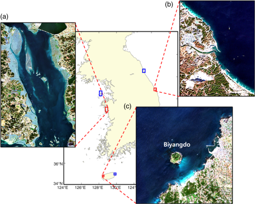
In an effort to generate a robust SDB model, the team selected three distinct coastal regions of the Korean Peninsula, each offering unique environmental variables for analysis—Samcheok’s clear waters, Cheonsuman’s turbid conditions, and Hallim’s diverse seabed sediments.
The model was trained using this diverse satellite imagery alongside echo sounder-derived nautical charts, serving as validated reference points.
Machine learning techniques, particularly the application of a random forest algorithm, play a pivotal role in the model’s capacity to adapt to varying coastal environments.
By assessing how light penetrates and reflects off of different marine landscapes, this algorithm allows for more precise depth calculations across a spectrum of coastal conditions.
It promises significant improvements in SDB, a critical tool for marine safety, resource management, and environmental stewardship.
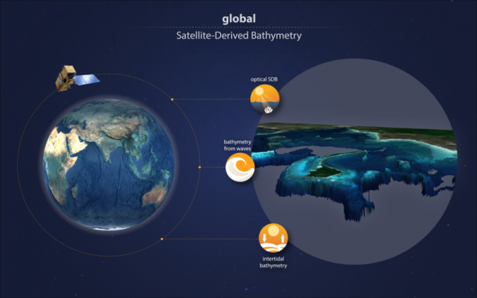 Visualization of global satellite-derived bathymetry from EOMAP.
Industry Background & Market Forecasts
The maritime industry relies heavily on accurate bathymetric data for various applications such as navigation, laying underwater cables, dredging, and environmental protection.
The market for bathymetry has been growing due to advancements in related technologies, including satellite-derived bathymetry, and an increasing interest in marine environments for exploration, tourism, and conservation.
The coastal zone management sector also benefits from precise bathymetric data, facilitating shoreline protection and sustainable exploitation of coastal resources.
Market forecasts suggest a positive trend for the growth of the satellite-based earth observation market, within which SDB is a niche but growing segment.
As countries invest more in coastal management and marine spatial planning, accurate and cost-effective bathymetric data becomes increasingly important.
Satellite-derived bathymetry services are becoming an attractive solution in this scenario, especially for areas where traditional survey methods are not feasible or economically viable.
Current Progress in SDB Technology
The milestone achieved by the Korean research team is part of a broader industry effort to leverage machine learning and artificial intelligence (AI) in the realm of earth observation.
Their work aligns with other technological advancements that aim to improve data acquisition and processing capabilities in environments where traditional methods are limited.
The accuracy of SDB methods has been steadily improving, resulting in increased resolution of the seabed mapping and extended capabilities in deeper waters.
Major players in the satellite imagery and remote sensing field continue to launch more sophisticated satellites capable of providing higher resolution images, which in turn contribute to the refinement of SDB methods.
In addition to the European Space Agency’s contributions with the Sentinel missions, other organizations and companies are also deploying satellites which could further enhance the capabilities of SDB.
Challenges Facing the Industry
Despite advancements, there are several challenges that remain within the industry.
The quality and accuracy of SDB can still be limited by factors such as water clarity, surface waves, seabed reflectivity, and the presence of marine flora and fauna.
Furthermore, the effective integration of machine learning models into operational SDB services requires extensive validation and continuous adjustments to cope with the dynamic marine environment.
Another significant issue is the availability of open-source data and the need for collaboration between different entities to enable the creation of comprehensive global bathymetric datasets.
Moreover, there are concerns regarding matters of data security and privacy, especially when it involves sensitive maritime domains.
Potential Impact
The pioneering work of the Korean research team has the potential to impact several spheres including maritime safety, where enhanced SDB can greatly improve navigational charts, particularly for previously unmapped or inaccurately charted coastal areas.
The improvement in SDB technologies is also crucial for timely environmental monitoring and response—be it for oil spill containment, coastal erosion, or habitat preservation efforts.
In terms of resource management, better bathymetric maps can aid in the sustainable development of marine resources, including fishing zones, aquaculture sites, and renewable energy installations like wind farms.
The advancements can also benefit archaeological exploration by making ancient submerged landscapes more accessible for study, which was once only possible with expensive underwater surveys.
Given the rapid evolution of technologies and the rising importance of cost-effective and high-quality marine data, the SDB industry is poised for significant growth and innovation in the coming years, benefiting a range of stakeholders from policy makers to the scientific community and commercial enterprises.
- PHYS : Estimating coastal water depth from space via satellite-derived bathymetry
- YouTube : Satellite Laboratory for UN Ocean Decade Designing observing systems for ocean boundaries
- SpaceDaily : New Satellite Technology Maps Coastal Depths with Enhanced Precision
- Cordias : Powerful tool surveys water depth in shallow waters from space
- Marine Technology : Danish Geodata Agency, EOMAP to Chart the Shallow Waters of Denmark
- Hydro : EOMAP to provide global shallow water bathymetry for Copernicus Marine Service
Hydro : The role of satellite-based mapping in hydrography
ReplyDelete