Saturday, April 19, 2014

Big shore break

Gas Chambers is a fast, hollow and shallow point break type of wave.
Being that it is a high performance wave it is well suited for the average to pro level surfer.
Sandy's beach is the host of Gas Chambers, located on the North Shore of Oahu about a 1/4 of a mile north of Ehukai Beach Park and 1/2 a mile west of Sunset Beach Park.

Friday, April 18, 2014

Frigid Winter? Blame 4,000 years of wild Jet Streams


The polar jet stream can travel at speeds greater than 100 mph.
Here, the fastest winds are colored red; slower winds are blue.

From LivScience by Becky Oskin

This winter's wild weather got its start 4,000 years ago, a new study finds.
The roaring jet stream, whose swooping winds drove frigid cold in the East and record warmth in the West this winter, first started twisting and turning about 4,000 years ago, according to a new analysis of ancient rainfall records from North America.
Jet stream winds race from west to east, and kinks in the narrow atmospheric current can suck Arctic cold south or hold warm air in place.

The study shows the jet stream's plunging pattern is a long-standing natural phenomenon.
However, the findings also suggest that global warming may boost the frequency or intensity of the curves, which would mean more winter extremes in the United States and Canada, the researchers said.
The study was published today (April 16) in the journal Nature Communications.

"The pattern we've observed points to a strong potential for an increase in winter extremes in the future," said Gabe Bowen, a study co-author and paleoclimatologist at the University of Utah.
Bowen and his co-authors examined the 8,000-year history of a weather pattern called the Pacific-North America Teleconnection.
The teleconnection refers to blobs of high and low atmospheric pressure above the Pacific Ocean and North America that direct the jet stream's strength and location.

Lead study author Zhongfang Liu, now at the Tianjin Key Laboratory in China, tracked the jet stream's location for the past 8,000 years with oxygen isotopes (atoms of the same element with different numbers of neutrons) from caves and lake sediments.
The ratio of certain oxygen isotopes reveals the history of rainwater, such as how cold the air was when the water fell and where the water came from.
Looking at the rainwater's history helps trace the pattern of the jet stream, which drives storms across the continent.
The team also compared their rainfall records with tree ring records and more recent instrumental data.

What is the jet stream?
How does the jet stream affect our weather?
This animation explains how the jet stream works.

 The rainfall patterns reveal the jet stream was relatively "flat," moving straight and steady from about 8,000 to 4,000 years ago, the study reports.
Then, about 4,000 years ago, the amount of solar energy reaching the Northern Hemisphere dropped. (This drop was caused by Earth's 20,000-year precession, the slow change in its rotation axis.)
The change in the sun's energy altered worldwide climate, such as triggering a stronger El Niño/La Niña cycle and a shift in monsoonal rainfall over India and Pakistan.

The jet stream pattern also shifted 4,000 years ago, going from flat to curvy over a period of about 500 years, the researchers found.
For example, the isotopes show more Arctic air moving south in the East, and more tropical air heading north in the West, consistent with wrinkles in the jet stream.
The curves help explain why some parts of North America became colder or wetter, while others grew drier or warmer, Bowen said.
"We knew the changing seasonality of the climate in North America wasn't uniform, and we were able to link it to this change in the jet stream," Bowen said.

These maps show winter temperature patterns (top) and winter precipitation patterns (bottom) associated with a curvy jet stream.
Credit: Zhongfang Liu, Tianjin Normal University, China

Sun to blame?

So was this winter's bizarre weather the result of natural climate swings?
Not at all, Bowen said.
"All things being equal, with the solar forcing that kicked in 4,000 years ago, we'd actually expect to be heading the other way now and starting to decrease the jet stream curviness," Bowen told Live Science.


A short review of how the jetstream and Rossby waves work, and some emerging indications that the dynamics may be changing in a warming world.

Several recent studies have argued that the jet stream's twists and turns are being exacerbated by climate change.
That's because the jet stream's high-speed air current forms at the border between hot and cold air masses.
As global warming changes the distribution of hot and cold air on the planet, the location and pattern of the jet stream may change too.

"Whether the Pacific-North America Teleconnection will continue to vary in the future as it has for the past few thousand years will have important implications in terms of water availability and climate in the western United States," said Max Berkelhammer, a hydrologist at the University of Illinois, Chicago, who was not involved in the study

But until now, only a century of instrumental records have been available to model the jet stream's response to global warming.
The new study "gives us a good look at natural variability so that we can gain a better understanding about how the jet stream has responded to past changes," said Lesleigh Anderson, a research geologist with the U.S. Geological Survey who was not involved in the study
"This is what we need to know to better understand what could happen in the future with rising carbon dioxide."

Thursday, April 17, 2014

Theories on how a South Korean passenger ferry suddenly sank


The vessel was travelling from Incheon port, in the north-west, to the southern resort island of Jeju.
Most of the people on board were high school students.
  
From CNN

As divers searched frigid waters off South Korea in low visibility, hoping to save hundreds of passengers, a dominant theory began to emerge about how the ferry sank.

Area of the sinking on the GeoGarage nautical chart viewer

It most likely struck something in the water, said Peter Boynton, a retired U.S. Coast Guard captain.
"The speed with which this ferry began to list and then roll over on its side suggests significant damage, most likely causing major flooding that would cause a vessel of this size -- almost 500 feet long -- to quickly roll onto its side. That's very likely the result of significant damage," he said.
Some passengers reported hearing a loud bang before the ship began sinking.
That could be from cargo shifting or "some other internal damage," Boynton told CNN's "New Day." "But it does sound, from initial reports, it was more likely that something was struck."


When the ship left Seoul, it traveled through fog, which may have put it off course, said Mary Schiavo, former inspector general for the Department of Transportation.
"So if they hit something, that would have meant they were out of the channel, which is quite easy to do," Schiavo said.
But the South Korean Oceans and Fisheries Ministry said Thursday that the ferry did not deviate significantly from its intended route.
The agency approved the ferry's intended route, and "there was no huge difference between their plan and the actual track chart," spokesman Nam Jae Heon said.

 Rescue crews attempt to save passengers from the ferry.

Schiavo said other possibilities include engine failure or an explosion, particularly in the engine room.
"But that probably alone wouldn't account for the sinking this quickly. It probably was something else that happened," she said.
Making matters worse, the ferry carried dozens of vehicles. Once an auto deck is breached, "it's typically open to very significant flooding," Boynton said.
That could explain "why the ferry in just a matter of hours began to roll onto its side so quickly."
Coast guard and navy ships, as well as fishing boats, rushed into the area.


 Rescue teams and fishing boats try to rescue passengers on April 16.

For rescue divers, a combination of factors makes saving people especially difficult: very cold waters, strong currents and low visibility, made worse by nightfall.
"The underwater challenges are very, very significant and pose, I would think, tremendous risk for the people who I'm sure are doing their best to help," Boynton said.
For the passengers, the most immediate danger is the cold.
"Pretty much everyone we saw was wearing a life jacket," journalist Andrew Salmon reported on CNN International.
"So the concern is hypothermia. If you're not picked up within two hours, you're in significant danger -- your body core goes cold."

 Military and civilian ships and helicopters have been searching for survivors

Some of the rescued passengers report that when the ship began to sink, they were told to jump into the water immediately -- and not to take time to get into life boats.
Sometimes after a breach, as the water begins gushing in, "there's a sucking, there's a motion, that just makes it impossible to fight," Schiavo said.
"So the order to abandon ship might have indicated that. ... It's almost like a suction that occurs when the water starts coming on, and you can't fight it."
But other passengers said they were told to stay on the ship. Sometimes, "conflicting commands" are given, Schiavo said.
"There can be a lot of confusion in an event like this."

Links :
  • BBC : South Korea ferry: Hundreds missing as ship sinks

NZ Linz update in the Marine GeoGarage

As our public viewer is not yet available
(currently under construction, upgrading to Google Maps API v3 as v2 is officially no more supported),
this info is primarily intended to
our iPhone/iPad universal mobile application users
(Marine NZ on the App Store) 
and our B2B customers which use our nautical charts layers
in their own webmapping applications through our GeoGarage API.  


8 charts have been updated in the Marine GeoGarage
(Linz March update published March 21, 2014

Today NZ Linz charts (180 charts / 313 including sub-charts) are displayed in the Marine GeoGarage.

Note :  LINZ produces official nautical charts to aid safe navigation in New Zealand waters and certain areas of Antarctica and the South-West Pacific.


Using charts safely involves keeping them up-to-date using Notices to Mariners
Reporting a Hazard to Navigation - H Note :
Mariners are requested to advise the New Zealand Hydrographic Authority at LINZ of the discovery of new or suspected dangers to navigation, or shortcomings in charts or publications.

Wednesday, April 16, 2014

US NOAA update in the Marine GeoGarage

As our public viewer is not yet available
(currently under construction, upgrading to Google Maps API v3 as v2 is officially no more supported),
this info is primarily intended to our iPhone/iPad universal mobile application users

(Marine US on the App Store)
and also to our B2B customers which use our nautical charts layers in their own webmapping applications through our GeoGarage API.

17 charts have been updated in the Marine GeoGarage
(NOAA update March 2014)

  • 11349 ed46 Vermilion Bay and approaches
  • 11353 ed7 Baptiste Collette Bayou to Mississippi River Gulf Outlet;Baptiste Collette Bayou Extension
  • 11468 ed44 Miami Harbor
  • 12241 ed23 York River Yorktown and Vicinity
  • 12327 ed106 New York Harbor
  • 13221 ed60 Narragansett Bay
  • 13241 ed18 Nantucket Island
  • 13244 ed42 Eastern Entrance to Nantucket Sound
  • 14804 ed25 Port Bay to Long Pond;Port Bay Harbor; Irondequoit Bay
  • 14805 ed25 Long Pond to Thirtymile Point;Point Breeze Harbor
  • 14845 ed28 Sandusky Harbor
  • 14863 ed32 Saginaw Bay;Port Austin Harbor;Caseville Harbor;Entrance to Au Sable River;Sebewaing Harbor;Tawas Harbor
  • 14915 ed26 Little Bay de Noc
  • 18580 ed23 Cape Blanco to Yaquina Head
  • 25647 ed12 Pillsbury Sound
  • 25663 ed29 Pasaje de San Juan to Puerto de Humacao and Western Part of lsla de Vieques
  • 25664 ed18 Pasaje de Vieques and Radas Roosevelt
Today 1025 NOAA raster charts (2167 including sub-charts) are included in the Marine GeoGarage viewer (see PDFs files)

Note : GeoGarage blog : Great Lakes mariners get new NOAA nautical chart for St. Mary’s River


How do you know if you need a new nautical chart?
See the changes in new chart editions.
NOAA chart dates of recent Print on Demand editions

Note : NOAA updates their nautical charts with corrections published in:
  • U.S. Coast Guard Local Notices to Mariners (LNMs),
  • National Geospatial-Intelligence Agency Notices to Mariners (NMs), and
  • Canadian Coast Guard Notices to Mariners (CNMs)
While information provided by this Web site is intended to provide updated nautical charts, it must not be used as a substitute for the United States Coast Guard, National Geospatial-Intelligence Agency, or Canadian Coast Guard Notice to Mariner publications

Please visit the
NOAA's chart update service for more info.

Power from the oceans: Blue energy

Marine Current Turbines' tidal-energy converter in Strangford Lough, UK, generates power with underwater blades that can be raised for maintenance. (Siemens)

From Nature by Jeff Tollefson

After years in the doldrums, the quest to harvest energy from the oceans is gathering speed.

Several kilometres off the coast near Perth in Western Australia, hidden beneath the waves and out of sight of watchful boaters, three giant buoys will soon begin producing electricity as they bob to the rhythm of the Indian Ocean.
At 11 metres wide and 5 metres tall, the squat orange floats look a bit like giant pumpkins.
As waves pass by, the tethered buoys will drive hydraulic pumps on the sea bottom, converting the motion of the ocean into 720 kilowatts of electricity to power a nearby naval base.

Perth Wave Energy project animation

Carnegie Wave Energy of North Fremantle, Australia, plans to have the system — the latest attempt at harvesting power from the sea — up and running by June.
The pilot project will generate a lot of press, but veterans of the marine-energy field will watch warily to see how it fares.
This industry has taken a slow road: none of the myriad devices designed thus far has proved its worth in the highly competitive energy market, and few have survived prolonged exposure to the harsh conditions in the sea.
Despite an overall investment of around US$735 million over the past decade by a dozen leading companies, marine power from tide and waves has yet to take off.
In fact, it remains the most expensive form of power on Earth.

But the outlook has brightened for those hoping to tap this source of energy.
In the past few years, several major industrial leaders have acquired start-up companies that harvest energy from tides, the easiest type of marine power to capture.
In March, three projects were approved for Canada's Bay of Fundy, home to some of the largest tides on the globe.
The wave-energy industry, which is targeting a much larger but more elusive resource, has had a few setbacks, including a decision to scale back plans for an array off the coast of Oregon last month.
But there is little doubt that both types of marine energy will eventually grow.
Last year, the London-based consultancy Bloomberg New Energy Finance projected that up to 22 tidal projects and 17 wave projects generating more than one megawatt of electricity — enough to power around 250 homes — could be installed by 2020.

In theory, oceans could power the entire globe without adding any pollution to the atmosphere.
And they could provide a more dependable source of electricity than the wind or sun.
They are also geographically convenient: roughly 44% of the global population lives within 150 kilometres of the coastline.

Some nations have been using large, dam-like structures to block off inlets and draw power from tidal flow for decades, but the latest approaches are designed to be less intrusive.
Although the potential environmental impacts are still under investigation, many researchers say that the sea could turn out to be an even more benign source of power than wind.

Indeed, energy experts envisage a day when the sea will deliver a significant amount of reliable carbon-free power to islands and burgeoning coastal cities around the world.
“It has proved harder than people had expected at the start, but it has also proved possible,” says Neil Kermode, managing director of the European Marine Energy Centre, the leading test facility for wave- and tidal-energy devices in the Orkney Islands, UK.
“We have shown that you can make electricity from moving sea water, and that's a huge step forwards.”

Shifting tides

Twice a day, some 350 million cubic metres of tidal water flows through a narrow strait into Strangford Lough — a small inlet southeast of Belfast, UK — and then back out to sea.
With each trip, it passes a pair of 16-metre-long propellers attached to a central tower that is anchored to the floor of the channel.
The force of the water, equivalent to a wind blowing at 555 kilometres per hour, spins the propellers at up to 15 revolutions per minute, generating 1.2 megawatts of electricity.

In addition to the traditional propeller, tidal-power companies have experimented with contraptions such as corkscrews, hydrofoils and underwater kites.
The device used in Strangford Lough, however, is leading the way.
Built by Marine Current Turbines in Bristol, UK, the design has generated more than 90% of the industry's power to date, according to the company.


The achievements attracted the interest of engineering giant Siemens in Munich, Germany, which took control of the company in 2012.
Marine Current Turbines is now preparing to deploy its first array of five 2-megawatt machines — each costing roughly £9 million (US$15 million) — off the coast of Wales by 2016.
As well as boosting the size of the machines, the company added a third blade to reduce vibrations and make the machines more durable, says chairman Kai Kölmel.
But he cautions that progress is likely to be incremental.
“I think some of the venture capitalists are disillusioned, but this is not a quick-buck industry,” he says.
“The wind industry didn't start up rapidly either.”

Even with major companies such as Siemens entering the game, the biggest challenge remains attracting the money needed to do the engineering and build prototypes, says Christopher Sauer, chief executive of Ocean Renewable Power Company, based in Portland, Maine.
Sauer's company has developed and deployed, albeit briefly, a unique device off the coast of Maine that looks a bit like the spinning blades of a combine harvester.
The company is now working on a second-generation device that should be ready for deployment as early as 2015.
“We're doing the best that we can with the money we have,” he says.

Waves of energy

The power of waves is vast, but developing machines that can reliably extract that energy and withstand the often-punishing environment represents a wholly different kind of challenge. Companies have explored designs ranging from swinging flaps to gyroscopic devices that convert the rocking of a ship into a circular motion to drive an onboard generator.
Each has its advantages, but the idea behind Carnegie Wave Energy's bobbing buoys in Australia was to escape the rough battering of waves at the surface.
The submersion has the added advantage of keeping the devices out of sight and avoiding the debates over aesthetics that have arisen with wind farms.

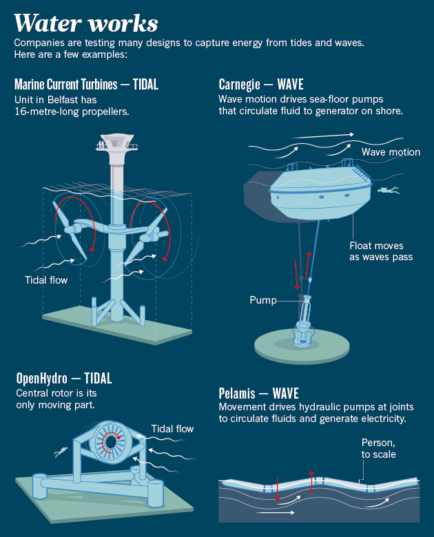
As the waves carry the buoys up and down, the sea-floor pumps circulate fluid through a closed loop that extends roughly 3 kilometres to an onshore generation facility (see 'Water works').
Operating like a bagpipe, the system accumulates pressure and then releases it gradually to generate a constant flow of electricity.
Each of the three devices can generate up to 240 kilowatts of energy.

“This is obviously not a commercial project, but there's not a commercial wave-energy facility in the world at the moment,” says Carnegie's chief operating officer Greg Allen.
Nonetheless, it represents progress, he says: each device generates three times more power than the version that was tested in the same waters in 2011.
Allen says that the first commercial projects could come as early as 2018.
To gain a toehold in the market, the company aims to compete with diesel-fired power generators on islands.

E.ON Pelamis machine in Orkney, April 2012

Pelamis Wave Power, based in Edinburgh, UK, has taken a different approach.
It uses a set of five connected buoys that float on top of the ocean and wriggle in the waves like a snake.
The segments move independently, and hydraulic pumps at each of the joints use the motion to drive fluids to an on-board generator.
The company is currently testing a pair of 750-kilowatt machines at the Orkney Islands testing site.
One of these is operated through a partnership with Scottish Power Renewables, a utility based in Glasgow.
New components have helped to reduce internal wear and tear in the hydraulic system, and the company is now working on algorithms that will allow the device to adjust each of its 16 hydraulic pumps individually and maximize energy production as it rides the waves.

The company hit some rough waters last year when the German energy firm E.ON pulled out of a partnership after a three-year project to test one of the devices in the Orkney Islands.
Founder and chief executive Richard Yemm remains optimistic, and says that the device is still in the water and producing power.
But he acknowledges that the company needs to strengthen its bonds with the industrial energy sector.
“We need the big industrial skills that the big companies have,” he says.

One reason that wave energy has attracted less commercial interest is that no one has yet managed to produce machines that can withstand the rough and tumble of the seas and produce electricity around the clock for sustained periods, says Angus McCrone, chief editor at Bloomberg New Energy Finance.
“These companies have gone through a lot of money,” he says, “and now the industry finds that it is going to have to spend significantly more to get the devices to commercialization.”

Green machines

The marine-energy industry has also encountered wary regulators who are well aware of controversies surrounding bird deaths caused by wind turbines.
Before Marine Current Turbines was allowed to start testing, it had to place seal spotters atop its turbines, who would hit an emergency cut-off button if any seals approached (which did not happen). And fears that seabed-mounted turbines designed by OpenHydro in Dublin, Ireland, could turn orcas into whale sushi nearly killed a proposal to test the devices in the Puget Sound near Seattle, Washington.

Gayle Zydlewski, a fish biologist at the University of Maine in Orono, says that she was able to capture only limited data on fish moving around and through Ocean Renewable Power's tidal unit in Maine.
Fish mostly seemed to avoid the turbine, she says, but she wonders: “What happens when you have another one next to it?”
Her team is still collecting baseline data, and her goal is to improve her models and understand how much fieldwork will be needed to determine potential impacts.

Others are busy in the lab. Biologists with the US Department of Energy have shot fish through turbines and exposed them to electromagnetic fields similar to those that surround the cables that transport the power back to shore.
Neither seemed to cause any permanent damage, according to the department.
In the case of the orcas in Puget Sound, energy-department researchers at the Pacific Northwest National Laboratory in Richland and Sandia National Laboratories in Albuquerque, New Mexico, studied a worst-case scenario: what if a curious orca stuck its head inside one of the turbines?
The teams scoured the literature, tested various rubber materials as surrogates for whale skin and built a model to understand the potential impact of a blade strike (see go.nature.com/aaptn2).
When a dead whale washed up onto the shore near Seattle last year, the scientists performed a computed tomography scan on the skull to look at skin and blubber thickness and used the information to improve their models.
They also took some whale skin and tested its strength in the lab.

The upshot of the study, released in January, was that an orca that got struck on the head by a turbine blade would probably swim away with little more than a bruise, says biological oceanographer Andrea Copping from Pacific Northwest National Laboratory, who led the effort.
“When whales hit a ship, it's the jawbone break that causes the death, but there wasn't enough force for that to happen,” she says.
The proposal to test the turbines in Puget Sound was approved by the Federal Energy Regulatory Commission on 20 March.

Copping is also heading an international collaboration that is pulling together all the environmental research on tidal- and wave-energy development.
The goal is to determine the most likely impacts and concentrate the research on those.

Its first report, issued in January 2013, focused on three areas: animal interactions, turbine noise and the effect of taking energy out of the marine system and slowing down the flow of water.
Thus far, the team reports, there is no evidence that there would be significant effects on marine animals or water flow, although the influence of large arrays is difficult to project.

The issue of sound could be more difficult to resolve.
Researchers have taken detailed measurements of individual devices, and blasted fish at volume levels that the animals would experience if they were effectively strapped to the turbines for 24 hours. Apart from some tissue damage, equivalent perhaps to what a teenager would experience at a rock concert, Copping says that the fish seem to be okay.
But the broader effects of an array of devices in an environment that is already saturated with sound from the motion of water as well as the loud drone of ships are hard to forecast.
A little noise might help the animals to avoid the machines, but too much could trouble whales and other animals that use sound to communicate.“Many or all of these projects are going to need a good deal of monitoring,” Copping says.
“The oceans are everybody's backyard.”

Developers, researchers and environmentalists all agree on one thing: to understand both the economics and the environmental impacts, the industry needs to put more machines in the water.
Bloomberg's McCrone says the projections for wave power are likely to drop in their next assessment, owing to declining industrial interest and the cancellation of some projects.
But he also believes that both sectors will eventually mature.

Bay of Fundy's world class tidal resource

One of the current hot spots is Canada's Bay of Fundy, which will soon host three projects, including a 4-megawatt installation featuring two devices from OpenHydro that will produce enough power for 1,000 homes by 2015.
If all goes well, the company hopes to expand the array to eventually generate 300 megawatts.
Although that would equal just one small coal-fired electricity plant, it would be a significant step forward for marine power.

“It will take off eventually,” McCrone says.
“There's a lot of energy in the sea.”

Tuesday, April 15, 2014

MH370: How do underwater sonar subs work?


The Bluefin-21 sonar device will search for Malaysia Airlines Flight 370 underwater
in "a slow and painstaking process."
 
From CNN

Four pings and an oil slick (JACC Press conf).
That's what the search for Malaysia Airlines Flight 370 has yielded so far.
No signs of wreckage, no assurances of exactly where the plane might be.
So officials are launching their next option: an underwater vehicle to scan the ocean floor.
But even that vehicle -- the Bluefin-21 -- faces plenty of challenges in finding the plane carrying 239 people.

3D animation of an Autonomous Underwater Vehicle (AUV) that surveys the sea floor.

How does the underwater vehicle work?

The Bluefin-21 is a probe equipped with side-scan sonar, or acoustic technology that creates pictures from the reflections of sound instead of light.
The device sends a pulse that produces a three-dimensional map of the seafloor, according to the U.S. Navy, which owns the Bluefin-21 used in the search.
An operator on the surface programs the vehicle.
"When it reaches the appropriate depth, it will turn on its sensors," said David Kelly, the president and CEO of manufacturer Bluefin Robotics.
"It will then run what's called the lawn mower pattern, which is a series of parallel lines or tracks, where it will go back and forth just like mowing your lawn."

Where will it be launched?

The Bluefin-21 will be launched in the most probable area of the pings that were detected by the Australian ship Ocean Shield.
From there, it will plunge to a depth of 4,000 to 4,500 meters (2.5 miles) -- roughly 35 meters above the ocean floor, the U.S. Navy said.
"It operates at a height above the bottom optimized for its sensors," Kelly said.

How fast and how far will the vehicle go?

The Bluefin-21's first mission will cover about 40 square kilometers (3.1 miles by 4.9 miles).
It'll probably take anywhere from six weeks to two months to scan the entire search area, the U.S. Navy said.
That's because the vehicle crawls at the pace of a leisurely stroll, said Sylvia Earle, an oceanographer from National Geographic who was chief scientist for the National Oceanic and Atmospheric Administration.
But the Bluefin-21 does create good images -- so good that they are "almost a picture of what's there ... but it's imaged with sound instead of with a camera."

What kind of terrain will it have to deal with?

The bottom of the search area is not sharply mountainous -- it's more flat and almost rolling, Australian chief search coordinator Angus Houston said.
But he said the bottom of the area probably has a lot of silt, which can "complicate" the search.
Houston cautioned against beliefs that the underwater vehicle will find wreckage.
"It may not," he said.
"This will be a slow and painstaking process."
When can we learn what the Bluefin-21 sees?
The vehicle has a 24-hour cycle, so it can be deployed only once a day.
And no information will be available until the end of each cycle, Houston said.
It will take two hours for the Bluefin-21 to get down to the search area.
Then it will scour the ocean bed for 16 hours and take another two hours to resurface.
After that, it will take another four hours to download and analyze the data collected, Houston said.
"The rate of information flow is certainly going to be a little bit more than a day apart," Matthews said.
What happens after the pingers die?

What happens if and when debris is found?

Once the debris field is found, other equipment -- such as remotely operated vehicles -- would be brought in to recover the black boxes, Earle said.
ROVs working at depths of 3 miles would require power conveyed down a cable from a ship above, said.
"There are not many pieces of equipment in the world able to do this."
And only a handful of countries have manned submarines capable of descending to such depths -- such as the United States, Russia, Japan, France and China, she said.

Why haven't they found any debris yet?

It's actually not that surprising, said CNN aviation analyst David Soucie, author of "Why Planes Crash."
The model used for tracking the debris could be incorrect, Soucie said.
He said that was the case when investigators were searching for evidence of Air France Flight 447, which plunged into the southern Atlantic Ocean in 2009, killing all 228 people aboard.
"They spent weeks looking for debris in the wrong area," he said.
The lack of debris could also mean that the plane did not break apart on impact, but instead sank largely intact, he said.
If that was the case, it could complicate the effort to retrieve the black boxes, since they were stored inside the tail of the plane.
Investigators would have to dismantle the tail in order to extract them and whatever secrets they may hold.
We heard pings last week.

Will the towed pinger locators be used again?

Probably not.
The plane's black boxes were expected to ping for only about 30 days, and Monday marks Day 38 of the search.
The towed pinger locator and the Bluefin-21 are hosted by the same Australian ship, and only one device at a time can search underwater, Houston said.
And because no new pings had been detected in the past six days, officials have pulled up the pinger locator in order to send down the unmanned vehicle.
Houston said it's unlikely the pinger locator will rejoin the search.
 
What do we know about the oil slick?

On Sunday night, the Australian ship Ocean Shield found an oil slick about 5.5 kilometers (3.4 miles) downwind from where the pings were detected.
A 2-liter sample was collected for analysis.
But it could take a few days to transfer that sample to a task force ship, bring it closer to shore, send it by helicopter to Perth, Australia, and then take it to a lab, Royal Australia Navy Capt. Brett Sampson said.

Will the mystery of Flight 370 be solved once the data recorders are found?

Not necessarily. The voice recorders retain only the last two hours of recordings.
And, since officials believe Flight 370 flew almost seven hours beyond the point where something went terribly wrong, crucial data have almost certainly been erased.
On the positive side, the depletion of the battery will not wipe out data.
Data has been known to survive years in harsh sea water conditions on modern recorders.

Monday, April 14, 2014

The U.S. Navy just announced the end of big oil and no one noticed

Navy researchers at the U.S. Naval Research Laboratory (NRL), Materials Science and Technology Division, demonstrate proof-of-concept of novel NRL technologies developed for the recovery of carbon dioxide (CO2) and hydrogen (H2) from seawater and conversion to a liquid hydrocarbon fuel.

From AddictingInfo

Announcing a major breakthrough, Navy researchers for the first time have converted seawater into CO2 and hydrogen, which could be used to produce jet fuel within a decade.

Surf’s up!
The Navy appears to have achieved the Holy Grail of energy independence – turning seawater into fuel:
After decades of experiments, U.S. Navy scientists believe they may have solved one of the world’s great challenges: how to turn seawater into fuel.

The new fuel is initially expected to cost around $3 to $6 per gallon, according to the U.S. Naval Research Laboratory, which has already flown a model aircraft on it.
Curiously, this doesn’t seem to be making much of a splash (no pun intended) on the evening news. Let’s repeat this: The United States Navy has figured out how to turn seawater into fuel and it will cost about the same as gasoline.

This technology is in its infancy and it’s already this cheap?
What happens when it’s refined and perfected?
Oil is only getting more expensive as the easy-to-reach deposits are tapped so this truly is, as it’s being called, a “game changer.”

I expect the GOP to go ballistic over this and try to legislate it out of existence.
It’s a threat to their fossil fuel masters because it will cost them trillions in profits.
It’s also “green” technology and Republicans will despise it on those grounds alone.
They already have a track record of trying to do this.
Unfortunately, once this kind of genie is out of the bottle, it’s very hard to put back in.

The Navy fleet line, but could be doing so under steam of a new kind of fuel.
The Navy’s 289 vessels all rely on oil-based fuel,
with the exception of some aircraft carriers and 72 submarines that rely on nuclear propulsion.

There are two other aspects to this story that have not been brought up yet:
  1. The process pulls carbon dioxide (the greenhouse gas driving Climate Change) out of the ocean. One of the less well-publicized aspects of Climate Change is that the ocean acts like a sponge for CO2 and it’s just about reached its safe limit. The ocean is steadily becoming more acidic from all of the increased carbon dioxide. This in turn poisons delicate ecosystems like coral reefs that keep the ocean healthy.
  2. If we pull out massive amounts of CO2, even if we burn it again, not all of it will make it back into the water. Hell, we could even pull some of it and not use it in order to return the ocean to a sustainable level. That, in turn will help pull more of the excess CO2 out of the air even as we put it back. It would be the ultimate in recycling. This will devastate oil rich countries but it will get us the hell out of the Middle East (another reason Republicans will oppose this). Let’s be honest, we’re not in the Middle East for humanitarian reasons. We’re there for oil. Period. We spend trillions to secure our access to it and fight a “war” on terrorism. Take away our need to be there and, suddenly, justifying our overseas adventures gets a lot harder to sell.
And if we “leak” the technology?
Every dictator propped up by oil will tumble almost overnight.
Yes, it will be a bloody mess but we won’t be pissing away the lives of our military to keep scumbags in power.
Let those countries figure out who they want to be without billionaire thugs and their mercenary armies running the show.

Why this is not a huge major story mystifies me.
I’m curious to see how it all plays out so stay tuned.

A Navy fuel ship replenishes the the U.S.S. Mount Whitney (right) on the Mediterranean Sea in October 2013.
(U.S. Navy photo by Mass Communication Specialist 1st Class Collin Turner/Released)

UPDATE:
People have been asking for more details about the process.
This is from the Naval Research Laboratory’s official press release:
Using an innovative and proprietary NRL electrolytic cation exchange module (E-CEM), both dissolved and bound CO2 are removed from seawater at 92 percent efficiency by re-equilibrating carbonate and bicarbonate to CO2 and simultaneously producing H2. The gases are then converted to liquid hydrocarbons by a metal catalyst in a reactor system.
In plain English, fuel is made from hydrocarbons (hydrogen and carbon).
This process pulls both hydrogen and carbon from seawater and recombines them to make fuel.
The process can be used on air as well but seawater holds about 140 times more carbon dioxide in it so it’s better suited for carbon collection.

Another detail people seem to be confused about: This is essentially a carbon neutral process.
The ocean is like a sponge for carbon dioxide in the air and currently has an excess amount dissolved in it.
The process pulls carbon dioxide out of the ocean.
It’s converted and burned as fuel.
This releases the carbon dioxide back into the air which is then reabsorbed by the ocean.
Rinse.
Repeat.

Links :
  • AFP : US Navy 'game-changer': converting seawater into fuel

Sunday, April 13, 2014

The Ark: Could Noah's tale be true?


From LiveScience

The new film "Noah" stars Russell Crowe as the man chosen by God to collect pairs of Earth's animals on a massive ark to save them from a global flood.
The film, which opened March 28, is sizing up to be a Biblical blockbuster, replete with star power and stunning special effects.
But how realistic is it?
While many people consider the story of Noah's Ark merely an instructive myth or parable about God's punishment for man's wickedness, others believe that the story is historically accurate.
To them, Noah's tale describes events that really happened only a few thousand years ago.

A plausible ark?

Henry Morris, author of "The Biblical Basis for Modern Science" (Baker House, 1984), a creationist text, states that "The ark was to be essentially a huge box designed essentially for stability in the waters of the Flood rather than for movement through the waters. ...
The ark was taller than a normal three-story building and about one and a half times as long as a football field.
The total volumetric capacity was equal to 1,396,000 cubic feet [39,500 cubic meters] ... equivalent to 522 standard railroad stock cars, far more than enough space to carry two of every known kind of animal, living or extinct."

The flaws in Morris's calculations become evident when you consider that, according to many creationists, Noah's Ark included hundreds of dinosaurs.
That would mean, for example, the brachiosaurus (two of them, of course), each of which weighed about 50 tons and reached 85 feet (26 meters) long.
Even if two representatives all of Earth's animals could somehow fit on the ark, enough space would be needed for drinking water and food for an entire year.

Furthermore, contrary to many depictions of the ark, God actually asked Noah to collect not one but seven pairs of "clean" animals and one pair of "unclean" animals (Genesis 7:2-3) — resulting, in some cases, in fourteen of many animals.
There simply would not be nearly enough space for all of them.

There's also the problem of collecting all those animals in the first place, anthropology professor Ken Feder notes in his book "The Encyclopedia of Dubious Archaeology" (Greenwood, 2010).
"How would koala bears from Australia, llamas from South America and penguins from Antarctica have managed the trip to the ark's location in the Middle East?" Feder writes.
"And how would their human caretakers have looked after this vast menagerie of animals? Noah, his wife, and his three sons and their wives (that's only eight people) providing food and water to the animals would have been an impossible task. What (or who) would the carnivores, living in close quarters with all those delicious herbivores, have eaten?"

Since the ark's purpose was merely to float (and not necessarily go anywhere), it would have had no means of propulsion (such as a sail) or even steering.
According to Morris, "As far as navigation was concerned, God Himself evidently steered the ship, keeping its occupants reasonably comfortable inside while the storms and waves raged outside."

Of course, this rather begs the question, because if God created the global flood and divinely steered the ark, then presumably He could have done any other miracle to assure the success of Noah's mission, from temporarily shrinking all the animals to the size of rats or even allowing them all to live for a year without food or water.
Once a supernatural miracle is invoked to explain one thing, it can be used to explain everything.


A closer look 

Another problem with the Ark story arises becausethere is no evidence for a global flood.
Creation stories from many different religions and cultures include flood stories, and Feder notes that if a worldwide flood had occurred, "The archaeological record of 5,000 years ago would be replete with Pompeii-style ruins — the remains of thousands of towns, villages and cities, all wiped out by flood waters, simultaneously. ...
It would appear that the near annihilation of the human race, if it happened, left no imprint on the archaeological record anywhere."

The lack of physical evidence of the great flood hasn't stopped modern believers from searching for Noah's Ark itself.
But the boat is conspicuously missing. It has never been found despite repeated claims to the contrary.
Forty years ago, Violet M. Cummings, author of "Noah's Ark: Fable or Fact?" (Creation-Science Research Center, 1973) claimed that the Ark had been found on Mount Ararat in Turkey, exactly as described in Genesis 8:4, which states, "and on the 17th day of the seventh month the ark came to rest on the mountains of Ararat."

In February 1993, CBS aired a two-hour primetime special titled, "The Incredible Discovery of Noah's Ark."
It included the riveting testimony of a man who claimed not only to have personally seen the Ark on Ararat, but also to have recovered a piece of it.
The claims were later revealed to be a hoax.
In March 2006, researchers found a rock formation on Mount Ararat that resembled a huge ark, but nothing came of that claim.

A few months later, a team of archaeologists from a Christian organization found yet another rock formation that might be Noah's Ark — not on Mt. Ararat but instead in the Elburz Mountains of Iran. That sensational discovery fizzled out, too.
In 2012, "Baywatch" actress Donna D'Errico was injured on Mount Ararat while on a quest to find Noah's Ark.
She said she had been inspired to search for the Ark ever since she saw a movie about it as a child.

The fact that Noah's Ark has been "discovered" so many times yet remains lost is something of a mystery in itself.
Whether "Noah" floats or sinks at the box office this weekend, it notably doesn't include the tagline "Based on a true story."