Saturday, January 13, 2024

The scary job of US Navy divers working 610m deep in the ocean


How does being deep in the ocean as a US Navy diver feel with saturation diving? 
“A lot of sailors talk about how they feel claustrophobic underwater
 US Navy Atmospheric Diving.
I kind of feel the opposite and am happy to share my experience
 There’s endless space, everywhere.
I remember a particular dive at dusk.
It was getting dark, and I descended to 80 feet in 450 feet of water and used my sonar equipment to locate a “mine shape” (a fake mine for testing & research) for a test we were doing.
I located the mine and grabbed onto the chain attached to the mine and looked down.
The rest of the equipment plunged into absolute darkness.
All I could feel was the vast expanse all around me, and I got the feeling that I might fall.
I just remember holding onto that chain and feeling like an endless fall was imminent.
I snapped back into focus, finished up the job, and went home.”
US Navy Divers are responsible for going underwater to carry out naval operations such as ship repairs and retrieval of ship wreckage.
These naval crew members are also responsible for escorting astronauts when they land in space capsules in the middle of the sea.
For some operations, they have to dive quite deep into the sea and, to successfully carry out such operations, there is a special technique these divers employ.

Friday, January 12, 2024

‘Really a sad day’ as Norway votes to allow deep-sea mining in Arctic waters

Norway is set to become the first country to move forward with deep-sea ùmining in its waters
 
From Mongabay by Elizabeth Claire Alberts

Norway’s parliament has voted to allow deep-sea mining to commence in the Norwegian Sea, a move that has garnered criticism from scientists and environmentalists.
While the Norwegian government insists that it can conduct deep-sea mining in a sustainable way, critics say these activities will put marine ecosystems and biodiversity at risk.
Norway will open a 281,000-square-kilometer (108,500-square-mile) area of the ocean for deep-sea mining, which mostly falls along its continental shelf.

Norway’s parliament has officially voted to allow deep-sea mining to go forward in the Norwegian Sea, despite warnings from scientists and conservationists that it could damage the marine environment.

This result was already anticipated in December 2023 after Norway’s minority government negotiated a deal with opposition parties to open up the ocean off Norway’s coast to deep-sea mining.

The government previously proposed opening a 329,000-square-kilometer (127,000-square-mile) portion of the Norwegian Sea to deep-sea mining.
However, this was later reduced to 281,000 km2 (108,500 mi2), an area nearly the size of Italy.
Most of this region falls across Norway’s extended continental shelf, which is technically in international waters, but over which Norway has jurisdiction.
Another portion falls within the territorial waters of the Svalbard archipelago, which Norway claims as its own exclusive economic zone, although this is contested by nations such as Russia, Iceland, the U.K.
and several EU countries.

Photo of the seabed mining plan from the Norwegian Government website.
Photo: Regjeringen.no
 
Experts say they believe the next step could be the Norwegian Offshore Directorate, the government agency responsible for regulating petroleum resources, inviting companies to bid for exploration licenses, which could happen as early as this year.
However, there’s currently no public timeline of forthcoming events.
 
Activists gathered outside Norway’s parliament, protesting the country’s plans for deep-sea mining.
Image by Greenpeace.


Norway intends to mine for minerals such as magnesium, cobalt, copper, nickel and rare-earth metals found in manganese crusts on seamounts and sulfide deposits on active, inactive or extinct hydrothermal vents.
The government says seabed mining is necessary to ensure that Norway is able to succeed in a “green transition.”

“We need to cut 55% of our emissions by 2030, and we also need to cut the rest of our emissions after 2030,” Astrid Bergmål, Norway’s state secretary for the energy minister, told Mongabay.
“So, the reason for us to look into seabed minerals is the large amount of critical minerals that will be needed for many years.”

Critics, however, say that minerals for renewable energy technologies could be obtained from land-based sources and recycling processes.

Bergmål said deep-sea mining will be done in a “step-by-step approach” and that it will only be permitted to go forward if the Norwegian government can ensure it will be done in a “sustainable way and with acceptable consequences.”

“If there is one country that can do this in a stepwise manner … that is Norway,” Bergmål said, “because when we say that we are going to put the world’s highest standards with respect to environmental concerns, we do it in practice.”

Norway isn’t the only country with ambitions to mine the deep sea.
Other nations, including the Cook Islands, China and Japan, are working on similar plans within their own jurisdictions.
 
Deep-sea coral off the East coast of the U.S.
Image by NOAA Ocean Explorer, Okeanos Explorer 

The high seas, which are areas beyond national jurisdiction, have also been earmarked for seabed mining, particularly in a region of the Pacific Ocean known as the Clarion-Clipperton Zone, where there are vast expanses dotted with potato-shaped polymetallic nodules containing minerals like manganese, nickel, cobalt and copper.
The International Seabed Authority (ISA), a U.N.-mandated mining regulator, has been overseeing negotiations to approve a set of rules that would govern this activity so it could potentially start in the near future.

Peter Haugan, a scientist who serves as policy director of Norway’s Institute of Marine Research and director of the Geophysical Institute at the University of Bergen, said Norway’s plans go against scientific advice and could endanger marine biodiversity.

“Destroying very sensitive and vulnerable areas and eliminating biodiversity … is a real risk,” Haugan told Mongabay.
“It’s really a sad day for Norway.”

Haugan said Norway’s decision could also be a “violation of the law” due to a lack of scientific evidence needed to assess the environmental impacts of future mining activities, which is legally needed for such decisions to be made.

Haldis Tjeldflaat Helle, a campaigner at Greenpeace Norway against deep-sea mining, who participated in a protest outside the Norwegian parliament on Jan.
9, said she’s still hopeful that environmentalists will be able to stop the industry before it goes ahead.

“We will use the tools we have available,” Helle told Mongabay.
“We will continue to do activism against this disruptive industry and try to influence Norwegian politicians to stop deep-sea mining.”

Links :

Thursday, January 11, 2024

Ethiopia’s controversial quest for the sea

Somalia Maps - Perry-Castañeda Map Collection - UT Library Online
For Ethiopia, access to the sea is linked to securing international trade and achieving national security.

From The Washington Post by Ishaan Tharoor

Many centuries ago, chroniclers conjured what was in antiquity called Ethiopia as a realm at the heart of global trade.
The treasures of Rome and India all flowed through its ports along the Gulf of Aden and the Red Sea.
Merchants and pilgrims made their way to the Middle East and Mediterranean world via its caravan routes and docks.
A 6th-century Byzantine historian described a kingdom with a vast fleet of wooden boats.
The ancient Greeks even named the southern part of the Atlantic Ocean, thousands of miles away from the Ethiopian highlands, the Ethiopian Sea.

Somali women gather to march against the Ethiopia-Somaliland port deal at the Yarisow stadium in Mogadishu, Somalia on Jan. 3.
(Feisal Omar/Reuters)


But modern-day Ethiopia is famously landlocked.
Apart from a few decades in the 20th century when Ethiopia had annexed neighboring Eritrea, Africa’s second-most populous nation has never had a coastline.
It maintains a meager, mostly riverine navy and pays tiny Djibouti some $1.5 billion a year for the privilege of accessing its ports and coastal infrastructure.

That’s why Abiy Ahmed, the ambitious Ethiopian prime minister, has long harbored visions of reaching the sea.
He has groused against his country’s “geographic prison” and summoned the legacy of seafaring medieval empires as one the contemporary Ethiopian state must redeem.
Ethiopia’s profound economic woes and constant internecine conflicts have not dented Abiy’s desires for maritime access — indeed, they may fuel them.

And last week, in what was a geopolitical bombshell in the Horn of Africa, Abiy appeared to achieve his goal.
Alongside Muse Bihi Abdi, president of the self-declared breakaway Republic of Somaliland, Abiy announced that the two parties had reached a memorandum of understanding that would see Somaliland lease to Ethiopia some 12 miles of its coastline by the port of Berbera.
In return, the autonomous entity that exists within the internationally recognized territory of Somalia may win something altogether more valuable: diplomatic recognition from Addis Ababa.


Somaliland declared its independence from Somalia three decades ago, amid the wave of turmoil that turned the country into a perennial failed state.
It comprises the northwestern wing of Somalia, and represents the territory once governed under a British protectorate that was separate from the Italian colony that mostly made up the rest of what is now independent Somalia.
The breakaway republic prints its own currency, maintains its own political institutions and has earned a reputation for being one of the more stable corners of the Horn of Africa — certainly more so than the areas controlled by the beleaguered government in Mogadishu.

But, apart from solidarity ties with the self-ruling island of Taiwan, Somaliland has not been recognized by any U.N. member state — and certainly any major regional power in Africa.
The autonomous region’s officials expect this deal, should it come to fruition, may trigger a meaningful shift.

“Their hope is that where Ethiopia goes, the rest of Africa will follow: the African Union is based in Addis Ababa,” explained the Economist.
“Abiy also enjoys strong relations with the United Arab Emirates.
Some foreign diplomats suspect the UAE, which is also close to Somalia’s government, may have played a part in brokering the deal.”

Cash-strapped Ethiopia is also paying for the port access by giving Somaliland’s authorities a stake in their national airline, a major continental carrier.
But the political dividend is clearly the most significant factor here for Somaliland, while Abiy hopes to succeed where previous efforts have failed.

“For years, Ethiopia’s government has sought to diversify its seaport access, including exploring options in Sudan and Kenya,” noted the New York Times.
“In 2018, it signed a deal to acquire a 19 percent stake in the port at Berbera, but the deal fell through.”

Somaliland President Muse Bihi Abdi and Ethiopian Prime Minister Abiy Ahmed in Addis Ababa, Ethiopia on Jan.
1 for the signing of the memorandum of understanding agreement, which allows Ethiopia to use a Somaliland port.
(Tiksa Negeri/Reuters)


Somalia, though, is outraged.
The country’s ambassador in Addis Ababa was recalled.
Protests and rallies against the developments have been held in Mogadishu.
On Saturday, Hassan Sheikh Mohamud, the country’s president, signed a bill that symbolically nullified the agreement between Ethiopia and Somaliland, since the latter exists within Somalia’s internationally-recognized borders.
“This law is an illustration of our commitment to safeguard our unity, sovereignty and territorial integrity as per international law,” he said.

It’s also an illustration of Mogadishu’s toothlessness in recent years, and inability to accept or quash Somaliland’s de facto independence.
But other major international blocs and powers have sided with Somalia: The European Union, African Union, Arab League and Organization of Islamic Countries all issued statements urging Ethiopia not to proceed.

“The Horn of Africa doesn’t need more tensions,” declared Josep Borrell, the E.U.'s top diplomat, after a phone call with Somalia’s president.
 

Why is Ethiopia risking war for a port?
 
The United States called on the dispute to be settled through dialogue; so too did Britain, which issued a statement offering its “full respect” to Somalia’s “sovereignty and territorial integrity.” 
Turkey, which has a significant footprint in Somalia and a tacit rivalry with the UAE in various corners of the region, also voiced its support for Somalia’s “unity.”

Abiy’s critics in the region cast him as a would-be East African hegemon.
But he argued that his nation has no “desire to forcefully coerce anyone” through this deal and simply wants to diversify (and cheapen) its access to the sea.
The move also may boost Abiy at home, buffeted by a tanking economy and ruinous ethnic conflicts.

“It will give Abiy the opportunity to rehabilitate his unpopular image in the country caused by his wars in the Tigray region, the violent insurgencies in Amhara and Oromo regions as well as the economic regression the country faced for the last few years,” Moustafa Ahmad, an analyst and researcher based in Hargeisa, Somaliland’s de facto capital, told Al Jazeera.
“Access to the sea has been presented as an existential issue for Ethiopian leaders over the years, and with this new deal, it will give Abiy domestic political gains.”

J. Peter Pham, a former U.S. ambassador and Washington envoy to the region, shrugged off concerns that a potential pact could stoke a wider crisis.
“It’s a real win-win, and it respects the reality of what’s on the ground in the Horn of Africa and not notional theories,” he told the BBC.
 
Links :

Wednesday, January 10, 2024

Oh good, hurricanes are now made of microplastics

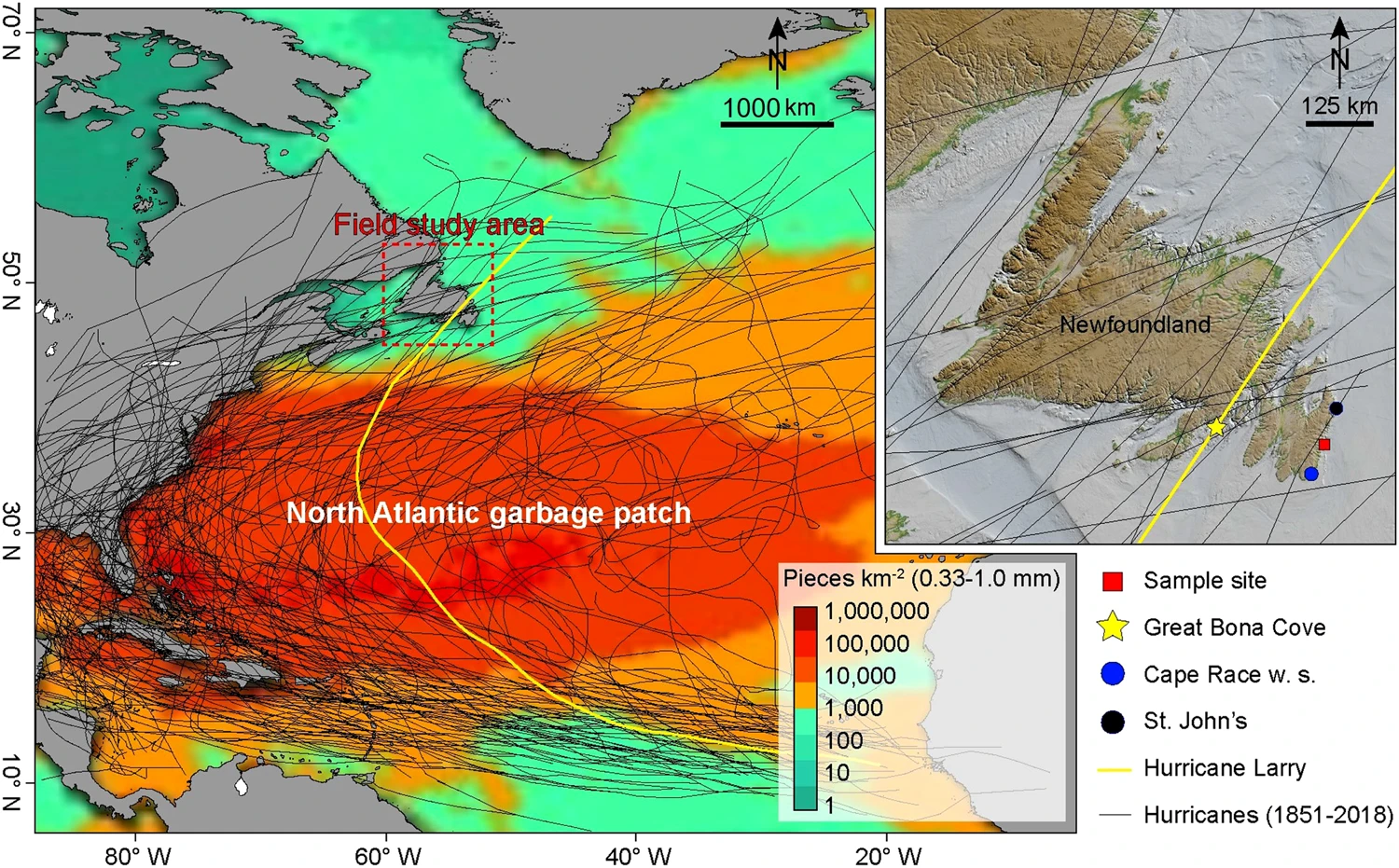
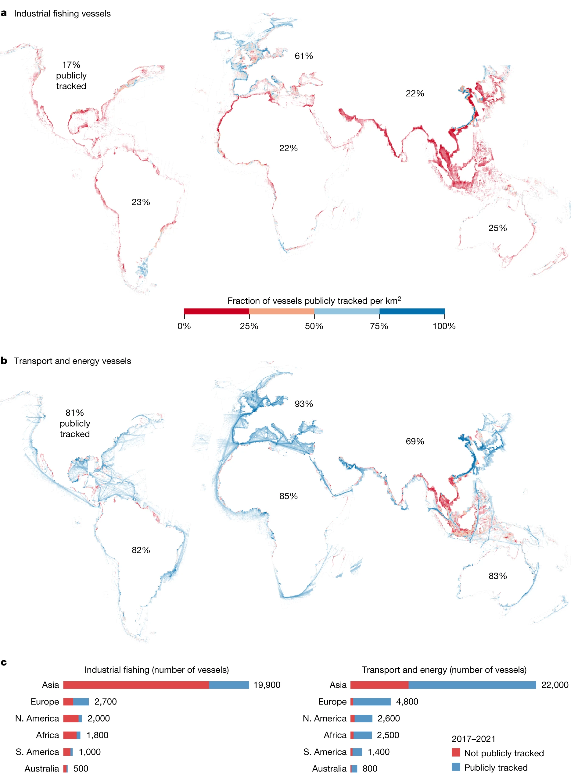
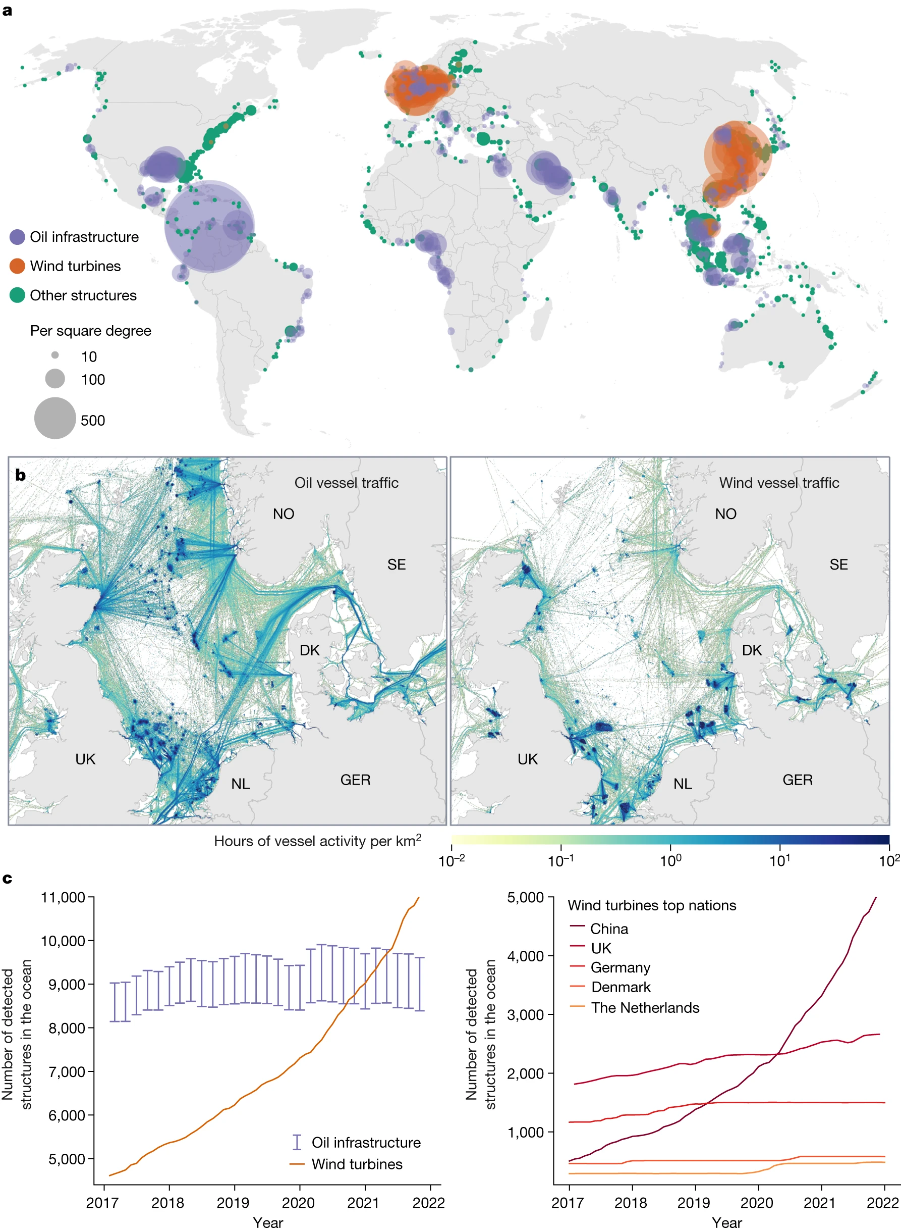
Illustration of the trajectory of all hurricanes since 1851, with emphasis on the trajectory of Hurricane Larry, on the large "garbage stain" of the North Atlantic, with high concentrations of microplastic. Image taken from Ryan et al (2023).
 
From Wired by Matt Simon

When Hurricane Larry made landfall two years ago, it dropped over 100,000 microplastics per square meter of land per day.
It’s another ominous sign of how plasticized the environment has become.


As Hurricane Larry curved north in the Atlantic in 2021, sparing the eastern seaboard of the United States, a special instrument was waiting for it on the coast of Newfoundland.
Because hurricanes feed on warm ocean water, scientists wondered whether such a storm could pick up microplastics from the sea surface and deposit them when it made landfall.
Larry was literally a perfect storm: Because it hadn’t touched land before reaching the island, anything it dropped would have been scavenged from the water or air, as opposed to, say, a highly populated city, where you’d expect to find lots of microplastics.

Anna Ryan collected samples of microplastics near Saint Michaels, N.L., a sparsely populated location with no major industry or other obvious sources of microplastics.
She says even the most pristine places now have plastics in the air.
(Submitted by Anna Ryan.)
 
As Larry passed over Newfoundland, the instrument gobbled up what fell from the sky.
That included rain, of course, but also gobs of microplastics, defined as bits smaller than 5 millimeters, or about the width of a pencil eraser.
At its peak, Larry was depositing over 100,000 microplastics per square meter of land per day, the researchers found in a recent paper published in the journal Communications Earth and Environment.
Add hurricanes, then, to the growing list of ways that tiny plastic particles are not only infiltrating every corner of the environment, but readily moving between land, sea, and air.

As humanity churns out exponentially more plastic in general, so does the environment get contaminated with exponentially more microplastics.
The predominant thinking used to be that microplastics would flush into the ocean and stay there: Washing synthetic clothing like polyester, for instance, releases millions of microfibers per load of laundry, which then flow out to sea in wastewater.
But recent research has found that the seas are in fact burping the particles into the atmosphere to blow back onto land, both when waves break and when bubbles rise to the surface, flinging microplastics into sea breezes.

Amber LeBlanc, a Dalhousie student who helped Ryan collect samples, checks a large glass cylinder set up near Saint Michaels, N.L., during Hurricane Larry.
(Submitted by Anna Ryan )
 
The instrument in a clearing on Newfoundland was quite simple: a glass cylinder, holding a little bit of ultrapure water, securely attached to the ground with wooden stakes.
Every six hours before, during, and after the hurricane, the researchers would come and empty out the water, which would have collected any particles falling—both with and without rain—on Newfoundland.
“It’s just a place that experiences a lot of extreme weather events,” says Earth scientist Anna Ryan of Dalhousie University, lead author of the paper.
“Also, it’s fairly remote, and it’s got a pretty low population density. So you don’t have a bunch of nearby sources of microplastics.”

A sample of the microplastics collected by Dalhousie students durring Hurricane Larry, as seen through a microscope.
(Submitted by Anna Ryan)

The team found that even before and after Larry, tens of thousands of microplastics fell per square meter of land per day.
But when the hurricane hit, that figure spiked up to 113,000.
“We found a lot of microplastics deposited during the peak of the hurricane,” says Ryan, “but also, overall deposition was relatively high compared to previous studies.” These studies were done during normal conditions, but in more remote locations, she says.

The researchers also used a technique known as back trajectory modeling—basically simulating where the air that arrived at the instrument had been previously.
That confirmed that Larry had picked up the microplastics at sea, lofted them into the air, and dumped them on Newfoundland.
Indeed, previous research has estimated that somewhere between 12 and 21 million metric tons of microplastic swirl in just the top 200 meters of the Atlantic, and that was a significant underestimate because it didn’t count microfibers.
The Newfoundland study notes that Larry happened to pass over the garbage patch of the North Atlantic Gyre, where currents accumulate floating plastic.

These new figures from Newfoundland are also likely to be significant underestimates—and necessarily so.
It remains difficult and expensive to look for the smallest of plastic particles: This research searched for bits as small as 1.2 microns (1.2 millionths of a meter), but there were likely way, way more pieces of plastic smaller than that falling into the instrument.
“From previous studies, we know that there’s an exponential curve for particle numbers as you go smaller,” says University of Birmingham microplastic researcher Steve Allen, coauthor of the new paper.
“So we’ve been talking about 113,000 particles per square meter a day of big stuff.
It just must be staggering, what is smaller.”

The researchers could also determine what kinds of plastic had fallen out of the sky.
“We saw not an overwhelming amount of one certain polymer—there’s a real variety,” says Ryan.
“In the ocean, there’s such a mix of particles that you have a little bit of everything.
And also because the hurricane came from so far away: It formed off the west coast of Africa, and you could potentially have particles picked up from all the way back there.”

This echoes what other scientists have been finding with microplastics in the environment.
Microplastic pollution comes from so many sources—our clothing, car tires, paint chips, broken-down bottles and bags—that it’s all mixed into a kind of multi-polymer soup out there.
That’s true both in the oceans and in the sky: In remote stretches of the American West, microplastic-sampling instruments similar to the one in Newfoundland have been gathering huge numbers of particles falling as plastic rain.
Microplastics haven’t just gone airborne, but have become a fundamental component of Earth’s atmosphere.

So microplastics don’t just flush into the sea and stay there—they blow into the atmosphere and back onto land, only to get picked back up again by winds and blown out to sea.
Back and forth, back and forth.
“It’s becoming quite clear that the ocean-to-atmosphere exchange is a very real thing,” says Allen.
“And the numbers in this paper here are just staggering.
It’s arriving in Newfoundland at just the time of year when all the biota—in the ponds and things—are all just trying to fatten up and breed for winter.”

Because microplastics travel so readily on winds and ocean currents, what were once considered pristine environments are now anything but.
Scientists are racing to figure out how the particles are affecting the organisms there.
Microplastics from Europe, for instance, have polluted the Arctic, in turn contaminating the algae Melosira arctica, which grows on the underside of sea ice.
The algae are the very base of the Arctic food chain, meaning all sorts of organisms are consuming them plus their accumulated microplastic.

As if hurricanes couldn’t get any worse, they’re yet another way for plastic particles to spread where they don’t belong.

Tuesday, January 9, 2024

Why mapping the entire seafloor is a daunting task, but key to improving human life


A cross section map of Challenger Deep, the deepest point on planet Earth.
John Nelson/Esri 
 
 From NPR by Regina G. Barber, Berly McCoy, Rebecca Ramirez 
 
Life at the bottom of the ocean is extreme.
It's pitch black, the temperature hovers right above freezing and the pressure is immense.

Although many species have evolved to survive and thrive at these depths, the seafloor is very much uninhabitable to humans.
In fact, only around a couple dozen people have actually been to the deepest part of the ocean floor, a place known as Challenger Deep.


A regular Styrofoam cup (L) next to a Styrofoam cup that traveled to Challenger Deep and back (R). Dawn Wright

Marine geographer Dawn Wright is one of those people. 
"It's a place that can either be horrifying and terrifying or it can be fascinating and infinitely beautiful. And for me, it was the latter."

Wright is the chief scientist of the Environmental Systems Research Institute.
She is also part of a global race to map the entirety of the world's ocean by 2030, which experts say is essential not just for pure scientific knowledge, but human safety and technological advancement. 
 

Challenge accepted

When Wright dropped into Challenger Deep, it was exciting — and purpose-filled.
As a marine geographer, she is interested in the "rocks and the motion at the bottom of the ocean."

Challenger Deep is in the Pacific Ocean inside of the Marina Trench. It's just shy of 11,000 meters, or 6.7 miles, below the ocean surface.
In July 2022, Wright and pilot and ocean explorer Victor Vescovo descended in a small submersible, then called the Limiting Factor.

Wright likens the experience to being in a space capsule.
"You're in a very small space. You're surrounded by instrumentation," she says.
"We had a whole series of oxygen tanks above us because we had 96 hours of oxygen, extra oxygen that we took along in case of emergency."


Dawn Wright (L) and Victor Vescovo (R) descend in a submersible to Challenger Deep, the deepest part of the ocean. Caladan Oceanic

Once the pair descended about 800 meters, they lost sunlight. 
"And it remains that way all the way down to the very bottom," says Wright. 
For her, that darkness made the fireworks show they were about to see that much more amazing.

Worms, jellyfish, anglerfish — "These species that are able to create their own light through bioluminescence," she says.
They use the light to find mates, hunt and — apparently — attempt to communicate with submersibles. 
"Victor noticed flashes of light as we reached that zone in the ocean.
And then he started flashing the lights of the submersible at them. And we saw them flash back."

Delights of deep sea marine creatures aside, Wright and Vescovo were focused on testing a special mapping device.
 
Mapping the seafloor

If so few people make it to the bottom of the ocean, why do we need to map it? It's less for road trips and more for, well, a lot of other things.
One of the most important: monitoring and predicting tsunamis.

That's because most tsunamis are a result of earthquakes on the seafloor.
Wright explains that "when you have that disruption on the ocean floor, the water above the ocean floor gets severely disrupted as well," which can generate large waves that can turn into tsunamis.

By mapping the seafloor, scientists can identify and monitor underwater areas that are earthquake-prone.
That could give coastal areas more warning time in the event of a tsunami.

The bottom of the ocean also serves as an important site for human innovations.
For example, submarine cables stretching between continents account for the vast majority of our internet traffic.
Also, offshore wind farm developers need to know the composition of the seafloor to anchor turbines.

Mapping the ocean floor may also help protect vulnerable marine habitat, or aid in finding people and objects lost at sea.

Historically, satellite data has been key to mapping the ocean, but Wright says these maps are too blurry to see fine details.


Credit: NPR

The solution?
Sound navigation and ranging, or sonar.
"It's like when you get a new eyeglass prescription," she says. 
"Everything comes into focus, and you're seeing things clearly."

The basic principal for sonar mapping is a ship or instrument sends pulses of sound from the ocean surface down toward the seafloor and waits for it to come back up.
Based on the amount of time it takes for the sound to return and factors like temperature and salt content, scientists can get a specific depth.
Scanning a whole area of the seafloor, then, will give you a depth — or bathymetry — map.
In the same way that a topography map shows elevation changes, a bathymetry map shows changes in depth. 

Seabed 2030

Only about 25 percent of the world's seafloor is currently mapped in detail, but an initiative called Seabed 2030 aims to get to 100 percent in just over six years.
The task, led by the Nippon Foundation and GEBCO, may seem daunting, but Wright says that just a few years ago, only around 6 percent of the ocean floor was mapped.

To complete the picture, ocean mappers are looking to industry to fill in some of the gaps. 
"The hope is that we can very quickly get to 40 percent if we can get a lot of these companies to release their data and to make it public," says Wright.

If the entire ocean floor isn't mapped by 2030 — one of many goals of the United Nations' Decade of Ocean Science for Sustainable Development — Wright says the work will continue.
But, she adds, "The longer that it takes us to get too close to 100 percent, for all the reasons that we've talked about, we are just going to be playing with fire, so to speak." 
 
Links :

Monday, January 8, 2024

When fishing boats go dark at sea, they're often committing crimes – we mapped where it happens

Workers flood a Vietnamese-flagged boat caught operating illegally off West Kalimantan, Indonesia on May 4, 2019 in order to sink it.  
 
From The Conversation by Heather Welch, Researcher in Ecosystem Dynamics, University of California, Santa Cruz

In January 2019, the Korean-flagged fishing vessel Oyang 77 sailed south toward international waters off Argentina.
The vessel had a known history of nefarious activities, including underreporting its catch and illegally dumping low-value fish to make room in its hold for more lucrative catch.

At 2 a.m. on Jan. 10, the Oyang 77 turned off its location transponder at the edge of Argentina’s exclusive economic zone – a political boundary that divides Argentina’s national waters from international waters, or the high seas.
At 9 p.m. on Jan. 11, the Oyang 77 turned its transponder back on and reappeared on the high seas.
For the 19 hours when the ship was dark, no information was available about where it had gone or what it did.
 

In a study published in Nov. 2022, I worked with colleagues at Global Fishing Watch, a nonprofit that works to advance ocean governance by increasing transparency of human activity at sea, to show that these periods of missing transponder data actually contain useful information on where ships go and what they do.
And authorities like the International Maritime Organization can use this missing data to help combat illegal activities at sea, such as overfishing and exploiting workers on fishing boats.

Illegal fishing causes economic losses estimated at $US10 billion to $25 billion annually.
It also has been linked to human rights violations, such as forced laborand human trafficking.
Better information about how often boats go dark at sea can help governments figure out where and when these activities may be taking place.

Countries can combat illegal, unreported and unauthorized fishing by checking paperwork, verifying catches and sharing information across borders.
 
Two million gigabytes of satellite imagery from 2017-2021 were analyzed to detect offshore infrastructure in coastal waters across six continents where more than three-quarters of industrial activity is concentrated.
ⓒ 2023 Global Fishing Watch

Going dark at sea

The high seas are the modern world’s Wild West – a vast expanse of water far from oversight and authority, where outlaws engage in illegal activities like unauthorized fishing and human trafficking. Surveillance there is aided by location transponders, called the Automatic Identification System, or AIS, which works like the Find My iPhone app.

Just as thieves can turn off phone location tracking, ships can disable their AIS transponders, effectively hiding their activities from oversight.
Often it’s unclear whether going dark in this way is legal.
AIS requirements are based on many factors, including vessel size, what country the vessel is flagged to, its location in the ocean and what species its crew is trying to catch.

A ship that disables its AIS transponder disappears from the view of whomever may be watching, including authorities, scientists and other vessels.
For our study, we reviewed data from two private companies that combine AIS data with other signals to track assets at sea. Spire is a constellation of nanosatellites that pick up AIS signals to increase visibility of vessels in remote areas of the world. Orbcomm tracks ships, trucks and other heavy equipment using internet-enabled devices.
Then, we used machine learning models to understand what drove vessels to disable their AIS devices.

Examining where and how often such episodes occurred between 2017 and 2019, we found that ships disabled their transponders for around 1.6 million hours each year.
This represented roughly 6% of global fishing vessel activity, which as a result is not reflected in global tallies of what types of fish are being caught where. 
 

This map shows the fraction of fishing vessel activity hidden by AIS disabling events from 2017 to 2019.
Heavy AIS disabling occurred adjacent to Argentina, West African nations and in the northwest Pacific – three regions where illegal fishing is common.
In contrast, the disabling hot spot near Alaska occurs on intensively managed fishing grounds and likely represents vessels going dark to avoid competition with other boats.
Global Fishing Watch, CC BY-ND
 
Data analysis reveals that about 75% of the world's industrial fishing vessels are not publicly tracked, with much of that fishing taking place around Africa and South Asia.
 
in Sicily
 
South Spain

Global Fishing Watch, CC BY-ND

Vessels frequently went dark on the high-seas edge of exclusive economic zone boundaries, which can obscure illegal fishing in unauthorized locations.
That’s what the Oyang 77 was doing in January 2019. 
 
The growing footprint of offshore development extends far beyond the fixed infrastructure.
 
 
Laundering illegal catch

The AIS data we reviewed showed that the Oyang 77 disabled its AIS transponder a total of nine times during January and February 2019.
Each time, it went dark at the edge of Argentinean national waters and reappeared several days later back on the high seas.

During the ninth disabling event, the vessel was spotted fishing without permission in Argentina’s waters, where the Argentinean coast guard intercepted it and escorted it to the port of Comodoro Rivadavia.
The vessel’s owners were later fined for illegally fishing in Argentina’s national waters, and their fishing gear was confiscated.

AIS disabling is also strongly correlated with transshipment events – exchanging catch, personnel and supplies between fishing vessels and refrigerated cargo vessels, or “reefers,” at sea.
Reefers also have AIS transponders, and researchers can use their data to identify loitering events, when reefers are in one place long enough to receive cargo from a fishing vessel.

It’s not unusual to see fishing vessels disable their AIS transponders near loitering reefers, which suggests that they want to hide these transfers from oversight.
While transferring people or cargo can be legal, when it is poorly monitored it can become a means of laundering illegal catch.
It has been linked to forced labor and human trafficking.


Image Credits: Global Fishing Watch
 
Valid reasons to turn off transponders

Making it illegal for vessels to disable AIS transponders might seem like an obvious solution to this problem.
But just as people may have legitimate reasons for not wanting the government to monitor their phones, fishing vessels may have legitimate reasons not to want their movements monitored.

Many vessels disable their transponders in high-quality fishing grounds to hide their activities from competitors. Although the ocean is huge, certain species and fishing methods are highly concentrated. For example, bottom trawlers fish by dragging nets along the seafloor and can operate only over continental shelves where the bottom is shallow enough for their gear to reach.

Modern-day pirates also use AIS data to intercept and attack vessels. In response, ships frequently disable their transponders in historically dangerous waters of the Indian Ocean and the Gulf of Guinea. Making AIS disabling illegal would leave fishing vessels more vulnerable to piracy. 
 

An AIS-equipped system on board a ship presents the bearing and distance of nearby vessels in a radarlike display format. 

Instead, in my view, researchers and maritime authorities can use these AIS disabling events to make inferences about which vessels are behaving illegally.

Our study reveals that AIS disabling near exclusive economic zones and loitering reefers is a risk factor for unauthorized fishing and transshipments.
At sea, real-time data on where vessels disable their AIS transponders or change their apparent position using fake GPS coordinates could be used to focus patrols on illegal activities near political boundaries or in transshipment hot spots.
Port authorities could also use this information onshore to target the most suspect vessels for inspection.

President Joe Biden signed a national security memorandum in 2022 pledging U.S. support for combating illegal, unreported and unregulated fishing and associated labor abuses.
Our study points toward a strategy for using phases when ships go dark to fight illegal activities at sea.

Links :

Sunday, January 7, 2024

Arkea Ultim Challenge


On January 7, 2024 in Brest, 6 exceptional sailors at the helm of extraordinary boats will embark on a unique adventure the ARKEA ULTIM CHALLENGE - Brest, 
 
the first round-the-world race in ULTIM 32/23.
6 sailors, 6 multihull, 1 round-the-world voyage, 1 city of departure and arrival: Brest
 Skippers involved:
Anthony Marchand - Actual Ultim 3
Armel Le Cléac'h - Maxi Banque Populaire XI
Charles Caudrelier - Maxi Edmond de Rothschild
Éric Péron - Adagio
Thomas Coville - Sodebo Ultim 3
Tom Laperche - Trimaran SVR-Lazartigue