Saturday, February 18, 2023

US Gulf of Mexico pipelines map

 
Offshore highlights crude and natural gas pipelines in the US Gulf of Mexico as well as pipeline and lease operators.
source : OffshoreMag 
 
visualization with the GeoGarage platform (NOAA nautical raster chart)
 

Friday, February 17, 2023

London ship insurers accused of enabling fishing vessels to ‘go dark’

Sustainably caught skipjack tuna is offloaded in the Maldives.
Ships that ‘go dark’ are suspected of exploiting overfished tropical tuna stocks.
Photograph: Paul Hilton/Greenpeace


From The Guardian by Keren McVeigh

Complaint says switching off tracking devices should raise ‘red flags’ with insurers, as it could be covering illegal fishing activity and puts crew’s lives at risk


When it comes to illegal fishing, London’s ancient business of ship insurance may not get much attention.
But according to a new complaint, the UK capital’s insurance industry is partly to blame when fishing vessels “go dark” at sea by turning off their mandatory satellite tracking equipment.

In a filing to City of London watchdogs, the ocean conservation charity Blue Marine Foundation has argued that EU-flagged vessels operating in the Indian Ocean that go dark are in likely breach of international, flag state and coastal state law, and that the UK insurance industry is “enabling” them by continuing to provide cover, thereby putting seafarers’ lives at risk.

The complaint, made to the Financial Conduct Authority and the Prudential Regulatory Authority, is based on analysis of what the charity calls “highly inconsistent” use of AIS (Automatic Identification Systems) by 46 EU fishing vessels over four years, mostly owned by Spanish and French companies.

It pointed the finger at three British firms – the Britannia Steam Ship Insurance Association Ltd, British Marine and MS Amlin – for insuring the vessels despite the AIS problems.

A ship’s AIS tracks its location, acting as a safety and navigational aid that, in part, helps captains avoid collisions at sea.
Turning off this system for long periods puts the lives of crew at risk and raises transparency concerns, the charity said.

It said that while there is no suggestion the vessels studied were engaged in illegal activities, switching off AIS should raise “red flags” with insurers, as it means potential illegal or unauthorised activity, such as fishing in unauthorised areas, could be taking place.

One insurer, British Marine, told the Guardian the EU-owned vessels identified by the charity have been placed on its “watch list” because of the findings.

The complaint is based on peer-reviewed legal research by Blue Marine, published last month.
The paper, the Illegality of Fishing Vessels Going Dark and Methods of Deterrence, concluded that insurers have a duty to curb illegal behaviour, and suggested insurers enable vessels to “go dark” as a result of weak due diligence.

Priyal Bunwaree, senior legal counsel at Blue Marine and research author, said: “The legal analysis shows that EU-owned vessels operating in the Indian Ocean and ‘going dark’ could be in breach of AIS laws, and that UK insurers are likely enabling such behaviour by providing them with the cover they need to operate.”

Legal guidance from Lloyds and the Office of Financial Sanctions Implementation (OFSI) states that gaps in AIS transmission are a “red flag” for insurers, Bunwaree said.

The OFSI guidance recognises legitimate reasons for switching off the AIS, but it also states: “AIS is often intentionally disabled by vessels that seek to obfuscate their whereabouts, and is often practised by vessels seeking to conduct illicit trade.”

Jess Rattle, head of investigations at Blue Marine, said: “We are calling on insurers to look into the AIS histories of vessels and carry out thorough risk assessments before deciding to insure them, and to insert clauses into their contracts that mandate the responsible and consistent use of AIS.”

These risk assessments are vital for crew safety and the transparency of fishing fleets operating “out of sight” and exploiting tropical tuna stocks, of which two out of three are currently overfished in the Indian Ocean, she said.
The EU is the largest harvester of overfished yellowfin tuna in the region.

Blue Marine said its monitoring of EU-owned fishing vessel data in the Indian Ocean over four years showed the trend of “highly inconsistent” AIS use was continuing.
A report by Blue Marine and the intelligence company OceanMind found that, between January 2021 and August 2022, EU-owned tuna vessels spent more time “dark” than they did transmitting on AIS.

Every one of the 16 Spanish-flagged vessels that was monitored by Blue Marine spent a month “dark”, it said, with some spending 140 days with their AIS off.
 
Traffic in a part of the Indian ocean of shipping vessels equipped with trackers, 13 February 2023.
Photograph: Marine Traffic (fishing vessels filter)
 
Start points (turquoise) and end points (yellow) for the AIS transmission gaps of one Spanish-owned tuna vessel, 2019-20.
Light blue lines show continuous AIS transmission, red line marks the then-current edge of the Somali HRA. (OceanMind / Blue Marine)

Legitimate reasons for a ship to “go dark” include to avoid detection in a high risk area, such as the one formerly around Somalia for piracy risk.
The recent OceanMind report, however, showed AIS gaps a significant distance from the former high-risk area, which has not existed since January, suggesting they are “highly unlikely” to be related to piracy.

Pablo Trueba, head of intelligence and compliance at OceanMind, said: “Unless you are within or really close to the high risk area for piracy, every other AIS switch-off is a risk indicator to avoid being observed and it could be to conduct unauthorised activities.”

The complaint to legal regulators argues that by continuing to insure vessels going dark in regions affected by sanctions, insurers are failing to follow industry guidance.

Kevin Shallow, director of underwriting for marine at QBE Europe, British Marine’s parent company, said: “Data has only recently been widely available to the industry in a way that gives detailed oversight and allows a more proactive stance in our response to AIS outage, and to deterring IUU (illegal, unreported and unregulated fishing).

“In collaboration with stakeholders across the fishing industry, including our own customers, we are working to improve safety, and identify those operators that do not meet appropriate standards.
In addition, our policy wordings have been strengthened to enable swift action through the withdrawal of coverage.

“However, we also have an obligation to act fairly to our customers and we recognise that there may be legitimate reasons the AIS transponder is turned off or is out of range.”

A spokesperson for MS Amlin said it had “clear controls” and “strict underwriting terms” that govern the actions and operations of any vessel the company insures.

“We do not insure vessels that fail to comply with international maritime laws, and it is made clear to our policyholders that those breaching maritime or indeed any international law, risk rendering their policy invalid,” the spokesperson said.

Britannia was approached for comment but did not respond.
 
Links :

Thursday, February 16, 2023

Antarctic researchers report an extraordinary marine heatwave that could threaten Antarctica’s ice shelves

 
An iceberg calving from Antarctica's Brunt Ice Shelf in February 2021.
Credit: Gallo Images/Orbital Horizon/Copernicus Sentinel Data 2021

From Inside Climate News by Bob Berwyn

The inexorable rise of ocean heat is now evident off the coast of West Antarctica, potentially disrupting critical parts of the global climate system and accelerating sea level rise.


Research scientists on ships along Antarctica’s west coast said their recent voyages have been marked by an eerily warm ocean and record-low sea ice coverage—extreme climate conditions, even compared to the big changes of recent decades, when the region warmed much faster than the global average.

Despite “that extraordinary change, what we’ve seen this year is dramatic,” said University of Delaware oceanographer Carlos Moffat last week from Punta Arenas, Chile, after completing a research cruise aboard the RV Laurence M.
Gould to collect data on penguin feeding, as well as on ice and oceans as chief scientist for the Palmer Long Term Ecological Research program.

“Even as somebody who’s been looking at these changing systems for a few decades, I was taken aback by what I saw, by the degree of warming that I saw,” he said.
“We don’t know how long this is going to last.
We don’t fully understand the consequences of this kind of event, but this looks like an extraordinary marine heatwave.”

If such conditions recur in the coming years, it could start a rapid destabilization of Antarctica’s critical underpinnings of the global climate system, including ice shelves, glaciers, coastal ecosystems and even ocean currents.
Such radical changes have already been sweeping the Arctic, starting in the 1980s and accelerating in the 2000s.

Data collected during Moffat’s most recent research voyage includes the first readings from temperature and salinity sensors that were deployed a few years ago, which will give the scientists a starting point for comparisons.
Moffat said it’s “too early, and difficult” to attribute this year’s conditions to long-term climate change until some peer-reviewed results are published.

“But it seems to me that this might be a really unprecedented event,” he said.
“These episodes of relatively rapid ocean warming that can persist for months have been occurring all over the place.
They haven’t been common in this region.”

He said ocean temperature readings going back to April 2022 speak to the persistence of the warm conditions off the Antarctic Peninsula.
The cruise covered an area more than 600 miles long and criss-crossed waters above the 125-mile wide continental shelf, documenting widespread ocean heating.

“That’s a very significant region,” he said.
“We don’t have data going back 30 years for the entire region.
But for the parts of the shelf for which we do have that data, it really seems extraordinary.
It’s very difficult to warm the ocean, and so when we see these conditions, that really speaks to a very intense forcing.”

A Dangerous Climate Feedback

Greenhouse gases, mostly from burning fossil fuels, are the force behind the warming of the atmosphere and the oceans.
The latest reports from Antarctica raise concern that a perilous climate feedback cycle of warmer oceans and melting ice has started around the continent, said Johan Rockström, director of the Potsdam Institute for Climate Impact Research.

“We know the melting of Antarctica is most sensitive to lubrication by water,” he said.
“It’s the sea melting the ice from below, it’s not atmospheric melting from above.
And this is really, really worrying … and quite surprising, because up until 10 years ago, we were absolutely convinced that the Greenland ice sheet and the Arctic was the more sensitive of the two poles.”


Up until about 2014, science suggested that Antarctica was still gaining ice, but “that has shifted,” he said.
An assessment released that year by the Intergovernmental Panel on Climate Change warned that there is likely an Antarctic tipping point between 1.5 and 2 degrees Celsius warming that would trigger irreversible melting of ice shelves and glaciers.

The Paris Climate Agreement to cap warming in that range was signed the following year with the understanding that a vicious climate cycle in Antarctica has global implications, raising sea level faster than expected, and contributing to the slowdown of the critical Atlantic thermohaline circulation that moves warm and cold water between the poles.
He said research shows that system of currents has been affected by global warming in recent decades, leaving more warm water in the Southern Ocean to drive marine heatwaves.

Instead of flowing northward to the Gulf Stream, the warmer water persists around Antarctica, because ”That whole system has slowed down by 15 percent,” he said.
“So when the circulation slows down, and you have more heat, you get more warm surface water in Antarctica.”
 
The Potential Start of an Icy Death Spiral

Antarctica was seen as a frozen redoubt until very recently because its ice sheets average more than a mile thick and cover an area as big as the contiguous United States and Mexico combined, spreading over about 5.4 million square miles with its center more than 1,000 miles from the ocean.

The continent is also encircled by a swift ocean current—the only one that flows all the way around the world–and an accompanying belt of jet stream winds several miles above it.
Both helped buffer Antarctica’s sea ice, as well as its land-based glaciers and floating ice shelves, from the rapid increase of climate extremes seen in most other parts of the world the past few decades.

But the observations from this year’s conditions may bolster several recent studies showing how global warming is eroding that protection.
An August 2022 study in Nature Climate Change suggested that “circumpolar deep water” at a depth of 1,000 to 2,000 feet has warmed by up to 2 degrees Celsius, which is in turn related to a poleward shift of the westerly wind belt.

That’s a critical depth where the water creeps up the continental shelf and beneath the floating ice shelf extensions of Antarctica’s huge land-based ice sheets, which poses a threat not only to ice in West Antarctica, already known to be vulnerable, but also to the thick, remote ice on the eastern half of the continent.

Warming through the world’s oceans is projected to persist in coming decades, so “the oceanic heat supply to East Antarctica may continue to intensify, threatening the ice sheet’s future stability,” the authors of the 2022 paper wrote.

Another study, published June 2022 in Science Direct, showed that the changes to the winds responsible for pushing the warmer water closer to shore will also persist if greenhouse gas emissions continue, so without immediate action to implement global climate policies, the Antarctic system could loop into a death spiral.

A 2016 study outlined a worst-case scenario in which warming would contribute to a rapid break-up of towering ice cliffs near the shore in a process that could speed up sea level rise, raising the water up to 7 feet by 2100 and 13 feet by 2150, increases that would be very hard to adapt to.

The water’s rise is already accelerating.
In the 1990s, the global average sea level increased at about 3 millimeters per year, but that annual rate increased to 4.5 millimeters in the last five years.
Between August 2020 and January 2021, sea level rose 10 millimeters.
Warming Waters Spread South

Researchers feel those buffering winds and ocean currents when they start their research voyages from South America, Africa or Australia because they have to cross the “Roaring Forties,” latitudes where fierce winds and deck-washing waves toss the vessels for a day or two before they end up in the relative calm of the Southern Ocean, where they can cruise smoothly under misty skies past floating sheets of ice.

The Southern Ocean encompasses all the water below 60 degrees South, and while it’s a mix of Atlantic, Pacific and Indian Ocean waters, it was geographically recognized as a distinct geographic entity by NOAA in 1999, precisely because it’s separated by those currents in the ocean and the sky that enclose Antarctica’s climate and ecosystems.

But it’s now clear that warming is dangerously infiltrating West Antarctica, said Rob Larter, a polar marine scientist with the British Antarctic Surveywho is currently measuring marine sediments in the Southern Ocean from the RV Polarstern to determine how fast and how far ice sheets have moved in the past.

Comparing the marine geology with climate data like temperatures and carbon dioxide levels through the millennia helps show how the ice will respond to human-caused warming, but some of the changes are visible without instruments, Larter said.

“The most striking changes I have witnessed are the retreat of the front of Pine Island Glacier after an abrupt change in its calving style in 2015,” he said, describing one of the glaciers in West Antarctica known to be particularly vulnerable to the warming ocean.
Up until that year, the glacier had been thinning, and then all of a sudden, big chunks started breaking off, he said.
“I visited the front on three different research cruises, in 2017, 2019 and 2020,” he said.
“And each time we had to go about 10 km further upstream due to the rapid retreat resulting from more frequent calving.”

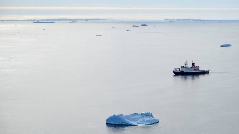
RV Polarstern in a nearly ice-free Bellingshausen Sea
(Photo: Daniela Röhnert).
 
The RV Polarstern is cruising in the Bellingshausen Sea, farther south than Moffat’s ship, but Larter said the ocean surface in their research area is also unusually warm, “largely a consequence of the fact most of the sea ice that’s usually here had melted or drifted away westward by the end of November,” he said.

Sea ice holds the water temperature to about 2 degrees below zero Celsius, Larter said, but the water during his current expedition has been nearly a degree above zero—almost three degrees Celsius warmer than normal.

He said declining sea ice could potentially affect the global ocean temperatures more rapidly by decreasing the flow of frigid water from the Southern Ocean along sea floors farther north
“The dense, cold water formed around Antarctica flows northward and fills the deepest parts of most ocean basins,” he said.
“In doing so it provides an important driver for the overturning thermohaline circulation.”
Those currents help balance the global climate by redistributing massive amounts of heat energy.

The process of producing that dense water starts with sea ice formation and melting, he said.
“Sea ice is a little fresher than the water it forms from due to brine rejection during ice crystal formation,” he said.
“The residual water becomes more saline, which makes it denser, causing it to sink, where it keeps the global refrigerator running as it spreads outward.”

It will be critical to monitor exactly how and where the warming ocean moves toward the ice shelves in West Antarctica, said Ted Scambos, a senior Antarctic researcher with the Earth Science and Observation Center at the University of Colorado, Boulder. 


For now, it’s not clear whether the warmer water will reach the Amundsen Sea,

which holds the Pine Island Glacier and Thwaites Glacier,” he said.
“If it does, or if it’s the start of a patch of warm water that will eventually drift in front of all of those glaciers, then, yeah, we would see a jump in the retreat rates for sure.”

Scambos helps coordinate a global effort studying the region’s most vulnerable ice, and he said the scientists are also probing and prodding far beneath the shelves to learn how the formation of grooves and cracks affects melting.
Sometimes, as the shelf drags across sections of the rough seafloor, the friction opens up gaps that can trigger more crack as the ice sags from above.

“The processes are real,” he said.
“They really do happen, they really do speed things up and they are being incorporated in the models.
But it’s not as dire as some of the more high end forecasts.”

While the tipping points that could cause runaway ice melt are difficult to reach, he said, research like Larter’s sediment maps shows that rapid retreats and meltdowns have happened in the geological past, potentially raising seas 2 to 3 meters in a century to submerge coastlines around the world.

“The runaway aspects of the process take hold fairly slowly.
In the natural world, this process of marine ice instability takes about a millennium,” he said.
But, “if we continue to drive it hard by warming the Pacific, by changing the circulation of air and ocean around Antarctica, we will get the fastest possible version of that marine ice sheet instability.”

Links :

Wednesday, February 15, 2023

Famous Australian beaches vulnerable to severe coastal erosion caused by La Niña

The Sunshine Coast shoreline is estimated to have retreated by 20 metres the past three years.
Photograph: Javier Leon 
 
From The Guardian by Donna Lu

Researchers say erosion of beaches along south-east coast – including at tourist hotspot Noosa – is significantly affecting local biodiversity


Some of Australia’s most famous beaches, including the tourist hotspot Noosa, are increasingly vulnerable to coastal erosion caused by successive years of La Niña, with experts voicing fears for local biodiversity.

Beaches along Australia’s south-east coast erode substantially during prolonged La Niña events, a study analysing four decades of satellite imagery has suggested.

The research comes amid warnings that erosion along Queensland’s Sunshine Coast, after three consecutive La Niña years, is significantly affecting local biodiversity.
 
Sunshine Coast with the GeoGarage platform (AHS nautical raster chart)

Dr Javier Leon, a senior lecturer in physical geography at the University of the Sunshine Coast, has been monitoring the shoreline between Noosa’s Main Beach and Coolum.
He estimated that over the last three years on average the shoreline has retreated by about 20 metres, while the sand dunes have receded between 7m and 10m and vertically eroded by 2m to 3m.

Usually, some turtle nesting occurs along that stretch of coast between November and January – “30 or so every year”, Leon estimates. 
“This year there have been no nests.”
“I’m assuming that it is because the beach and dunes have been eroded so there’s no place where turtles can [make] their nests,” he said, noting that there had been nesting activity further south, where beaches were less eroded.

“If you were to leave  coastal system by itself, the beach would move a lot. The real problem is when you have infrastructure behind, or even worse, on those dunes.” Leon cited Main Beach and Maroochydore as particularly vulnerable areas.

The Queensland analysis is in keeping with the findings of satellite research that studied more than 8,300km of coastline along the Pacific basin, looking at the effects of the El Niño-Southern Oscillation on wave-dominated sandy beaches.

Enso oscillates between warm El Niño, cold La Niña and neutral phases as a result of differences in sea surface temperatures in the Pacific Ocean.

Of the Australian coastline analysed, the researchers found that between 1984 and 2022, 48% of beaches experienced significant erosion during La Niña years.

“That signal is very clear in south-east Australia,” said the study’s first author, Dr Kilian Vos of the University of New South Wales. The erosion during La Niña was linked to a 7% increase in wave power and sea level changes, Vos said.

Conversely, El Niño was associated with an accumulation of sand across 75% of beaches analysed. Enso appeared to have the opposite effect on the other side of the Pacific, resulting in the accretion of sand on to beaches during La Niña years along the west coast of the Americas.

“Enso is very asymmetric,” Vos said. “El Niño events are very intense and very short, while La Niña events are rarely as strong but they last much longer.

Our Australian afternoon update email breaks down the key national and international stories of the day and why they matter

“Beaches kind of have a memory. If there have been many storms in the past year, the beach will be eroded and will take a long time to recover.”

He pointed to 2012-13 as an example, when the most extensive erosion in Australia was recorded.
That year the Enso was in the neutral phase, but it followed two consecutive years of strong La Niña conditions.
“This highlights how El Niño and La Niña can trigger prolonged erosion phases on sandy coastlines,” the study’s authors wrote.

The researchers studied only wave power but not the direction from which the waves arrived along the coast.

Leon, who was not involved in the study, said along Australia’s east coast waves tended to hit the beaches from a south-east direction, but “La Niña usually means more waves from the east”.
“As soon as you get too many easterly waves, then a lot of those beaches are not used to it, so they are prone to erosion,” he said. 
“That’s what we’ve observed in the last three years.”

Anthropogenic climate change would further complicate the natural cycle of coastline changes, Leon added. 
“The projections are that for the east coast of Australia, regardless of La Niña or El Niño, we will see waves shifting anti-clockwise, meaning they will come more and more from the east – because of climate change.”

The research was published in the journal Nature Geoscience.
 
Links :

Tuesday, February 14, 2023

Quirimbas Islands


November 24, 2021 
 
Visualization with the GeoGarage platform (UKHO nautical raster chart) 


From NASA by Emily Cassidi


The Quirimbas Islands stretch 322 kilometers (200 miles) along Mozambique’s coastline and are teeming with an impressive array of plants and animals.
The 32 small islands that make up the archipelago are partly linked to the coast by mangroves, sand bars, and coral reefs.

An astronaut on the International Space Station took this photograph of the northern part of the Quirimbas Islands, near the Tanzania border, on November 24, 2021.
Light blue-green water highlights the shallow complex of corals, sand, and seagrass surrounding the islands.
 
A map of the island in 1775
Après de Mannevillette, Jean-Baptiste-Nicolas-Denis d' (1707-1780) 
Bibliothèque nationale de France 

View with the GeoGarage platform (NGA nautical raster chart)

In 2018, the United Nations Educational, Scientific and Cultural Organization (UNESCO) selected the islands to be protected as one of its 738 biosphere reserves because of its unique biodiversity.
According to UNESCO, the islands are home to 3,000 floral species, of which 1,000 are endemic, meaning they are only found on the islands.

The islands’ waters host 52 species of corals, 140 species of mollusk, and eight species of marine mammals including whales and dolphins.
Five species of sea turtles are found there: loggerhead turtle (Caretta caretta), green turtle (Chelonia midas), leatherback turtle (Dermochelys coriacea), hawksbill turtle (Eretmochelys imbricata) and olive ridley (Lepidochelys olivacea).
All five of these species are listed by the International Union for Conservation of Nature as being threatened with extinction.


November 24, 2021

Vamizi, the long crescent-shaped island centered in the image above, is one of the largest islands of the Quirimbas Archipelago.
The island is an important nesting site for hawksbill turtles and green turtles.
Some 170 green turtle nests were observed on the island during 2019 and 2020, making it the species’ largest nesting site in Mozambique.

Increased tourism and fishing on and around Vamizi island in recent years has put pressure on the island’s marine ecosystem.
Certain fishing methods are hazardous to sea turtles, which can get accidentally caught in nets and tangled in fishing gear.


Concern about the health of marine species near the island led to the creation of Community Fishers’ Council (the Conselho Comunitário de Pesca), which established the Vamizi Community Sanctuary on the western side of the island as a no-fish zone.
The sanctuary covers about 10,000 hectares of reefs, mangroves, and deeper waters, and extends 5 kilometers out to sea.
 
Links :

Monday, February 13, 2023

How NOAA’s first undersea lab helped scientists study corals


A drawing of the HYDROLAB, showing a cross section of the inside.

From NOAA

In the early days of undersea research at NOAA, scientists needed to surface regularly when SCUBA diving to study coral reefs and other habitats.
This slowed down their progress, making it difficult to conduct longer studies.
All that changed with the introduction of the HYDROLAB.

What was the HYDROLAB?

The HYDROLAB was NOAA’s first undersea research habitat where aquanauts could live on the ocean floor for days or weeks at a time.
It was used by NOAA and its partners from approximately 1970 to 1985, in which time it housed over 700 scientists on more than 85 missions.
The HYDROLAB operated on the ocean floor in the Bahamas, then in St. Croix, in the U.S. Virgin Islands.

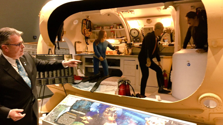
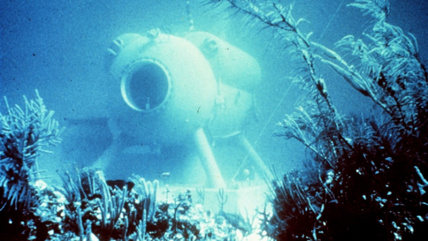
NOAA's HYDROLAB, based in the Caribbean beginning in the mid-70s, was an underwater lab for researchers.

What does this have to do with corals?

The HYDROLAB made it easier to study coral reefs.
The projects performed in the 1980s included studies of the life history and behavior of coral reef organisms, research on the chemical ecology and compatibility between the tissues of different sponges, and the development and testing of underwater fish marking and release techniques.


Two scientists in SCUBA gear float above a coral reef as they study it.
The HYDROLAB sits in the background.

What was it like living in the HYDROLAB?

The HYDROLAB was very small, only 16 feet long and 8 feet in diameter - a little bigger than a mid-size car.
In that space, it housed a lab, three bunks, and a moon pool, which allowed scientists to get in and out of the habitat while it was on the ocean floor.
It had six viewports, electricity, running water, and heat.
The HYDROLAB held four people, but since it only had three bunks, inhabitants had to rotate sleeping schedules.

When it was time to leave the HYDROLAB, the inhabitants had to spend at least 16 hours in a hyperbaric chamber, so they wouldn’t get decompression sickness (known as “the bends”).
This serious condition can lead to effects ranging from joint pain and rashes to paralysis and even death.

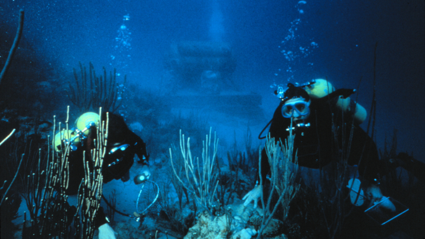
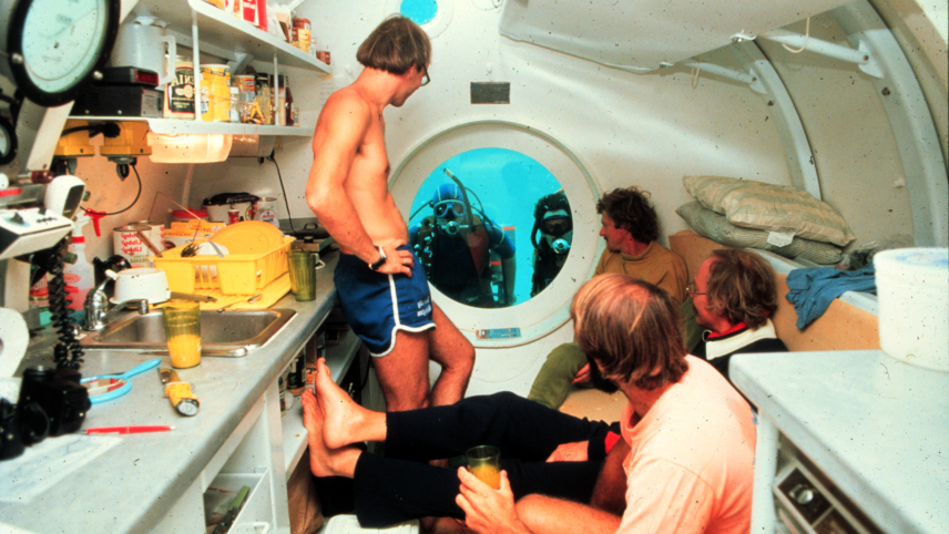
Four scientists inside the NOAA Hydrolab as it sits on the ocean floor, with two more scientists in SCUBA gear looking in through a window on the end of the structure.


Dive back in time to HYDROLAB: NOAA’s first undersea research habitat

Where is the HYDROLAB now?

NOAA still has the HYDROLAB, but its undersea days are over.
It was decommissioned in 1985 and replaced by the Aquarius for underwater research.
The Aquarius is a more modern undersea dwelling and is currently the only one in the world being used for marine science.
It resides in NOAA’s Florida Keys National Marine Sanctuary and is operated by the Florida International University.

The HYDROLAB is currently on display in the NOAA Science Center in Silver Spring, Maryland.


Former NOAA Research administrator Craig McLean points to the HYDROLAB, where three mannequins are staged as though they are working in the small lab it houses.
 
Links :

Sunday, February 12, 2023

Image of the week : ocean currents in a global ocean view

The Spilhaus projection, visualising global warm and cold ocean currents
courtesy of John Nelson 

Ocean surface currents on a planisphere


Links :