Saturday, August 6, 2011

Imoca 60 spectacular photo shooting


Very rare conditions : when beautiful light, strong winds and big waves come together, everything turns into magic;
30 knots of breeze, and waves due to long westerly wind period offshore Porquerolles island

From L'Express

Porquerolles (FRA) - This happen one time every ten years !

Perfect weather conditions, 30 knots breeze, big waves due to westerly wind, beautiful light and 2 brave sailors for a very spectacular photo shoot.

Photo © Guilain Grenier

Thank you Kito and Yann Regniau for this wonderful show !

Links :

Friday, August 5, 2011

Ancient tides different from today : some dramatically higher

Tides in the Bay of Fundy, which today are among the most extreme in the world, weren't nearly as large 5000 years ago. (Photo courtesy of NASA)

From Oregon University

The ebb and flow of the ocean tides, generally thought to be one of the most predictable forces on Earth, are actually quite variable over long time periods, in ways that have not been adequately accounted for in most evaluations of prehistoric sea level changes.

Due to phenomena such as ice ages, plate tectonics, land uplift, erosion and sedimentation, tides have changed dramatically over thousands of years and may change again in the future, a new study concludes.

Some tides on the East Coast of the United States, for instance, may at times in the past have been enormously higher than they are today – a difference between low and high tide of 10-20 feet, instead of the current 3-6 foot range.

And tides in the Bay of Fundy, which today are among the most extreme in the world and have a range up to 55 feet, didn’t amount to much at all about 5,000 years ago.
But around that same time, tides on the southern U.S. Atlantic coast, from North Carolina to Florida, were about 75 percent higher.

Low tide in the Bay of Fundy. (Photo courtesy of NASA)

The findings were just published in the Journal of Geophysical Research.
The work was done with computer simulations at a high resolution, and supported by the National Science Foundation and other agencies.

“Scientists study past sea levels for a range of things, to learn about climate changes, geology, marine biology,” said David Hill, an associate professor in the School of Civil and Construction Engineering at Oregon State University.
“In most of this research it was assumed that prehistoric tidal patterns were about the same as they are today. But they weren’t, and we need to do a better job of accounting for this.”

One of the most interesting findings of the study, Hill said, was that around 9,000 years ago, as the Earth was emerging from its most recent ice age, there was a huge amplification in tides of the western Atlantic Ocean.
The tidal ranges were up to three times more extreme than those that exist today, and water would have surged up and down on the East Coast.

One of the major variables in ancient tides, of course, was sea level changes that were caused by previous ice ages.
When massive amounts of ice piled miles thick in the Northern Hemisphere 15,000 to 20,000 years ago, for instance, sea levels were more than 300 feet lower.

But it’s not that simple, Hill said.

“Part of what we found was that there are certain places on Earth where tidal energy gets dissipated at a disproportionately high rate, real hot spots of tidal action,” Hill said.
“One of these today is Hudson Bay, and it’s helping to reduce tidal energies all over the rest of the Atlantic Ocean. But during the last ice age Hudson Bay was closed down and buried in ice, and that caused more extreme tides elsewhere.”

Many other factors can also affect tides, the researchers said, and understanding these factors and their tidal impacts is essential to gaining a better understanding of past sea levels and ocean dynamics.

Some of this variability was suspected from previous analyses, Hill said, but the current work is far more resolved than previous studies.
The research was done by scientists from OSU, the University of Leeds, University of Pennsylvania, University of Toronto, and Tulane University.

“Understanding the past will help us better predict tidal changes in the future,” he said.
“And there will be changes, even with modest sea level changes like one meter. In shallow waters like the Chesapeake Bay, that could cause significant shifts in tides, currents, salinity and even temperature.”

Links :

Thursday, August 4, 2011

USA NOAA update in the Marine GeoGarage

12281 Baltimore harbor

28 charts have been updated in the Marine GeoGarage (NOAA update June/July 2011)

  • 11347 CALCASIEU RIVER AND LAKE
  • 11353 BAPTISTE COLLETTE BAYOU TO MISSISSIPPI RIVER GULF OUTLET;BAPTISTE COLLETTE BAYOU EXTENSION
  • 11363 CHANDELEUR AND BRETON SOUNDS
  • 11468 MIAMI HARBOR
  • 11469 FOWEY ROCKS; HILLSBORO INLET TO BIMINI ISLANDS
  • 11470 FORT LAUDERDALE PORT EVERGLADES
  • 11484 PONCE DE LEON INLET TO CAPE CANAVERAL
  • 11511 OSSABAW AND ST. CATHERINES SOUNDS
  • 12200 CAPE MAY TO CAPE HATTERAS
  • 12235 CHESAPEAKE BAY RAPPAHANNOCK RIVER ENTRANCE, PIANKATANK AND GREAT WICOMICO RIVERS
  • 12278 CHESAPEAKE BAY APPROACHES TO BALTIMORE HARBOR
  • 12281 BALTIMORE HARBOR
  • 12358 NEW YORK LONG ISLAND, SHELTER ISLAND SOUND AND PECONIC BAYS;MATTITUCK INLET
  • 16556 CHIACHI ISLAND TO NAGAI ISLAND;CHIACHI ISLANDS ANCHORAGE
  • 18740 SAN DIEGO TO SANTA ROSA ISLAND
  • 11316 MATAGORDA BAY AND APPROACHES
  • 11389 ST JOSEPH AND ST ANDREW BAYS
  • 11488 AMELIA ISLAND TO ST. AUGUSTINE
  • 11504 ST. ANDREW SOUND AND SATILLA RIVER
  • 12334 NEW YORK HARBOR UPPER BAY AND NARROWS-ANCHORAGE CHART
  • 13248 CHATHAM HARBOR AND PLEASANT BAY
  • 13251 BARNSTABLE HARBOR
  • 13286 CAPE ELIZABETH TO PORTSMOUTH; CAPE PORPOISE HARBOR; WELLS HARBOR; KENNEBUNK RIVER; PERKINS COVE
  • 13303 APPROACHES TO PENOBSCOT BAY
  • 18022 SAN DIEGO TO SAN FRANCISCO BAY
  • 18441 PUGET SOUND-NORTHERN PART
  • 18524 COLUMBIA RIVER CRIMS ISLAND TO SAINT HELENS
  • 25670 BAHIA DE SAN JUAN

Today 1019 NOAA raster charts (2166 including sub-charts) are included in the Marine GeoGarage viewer.

Note : NOAA updates their nautical charts with corrections published in:
  • U.S. Coast Guard Local Notices to Mariners (LNMs),
  • National Geospatial-Intelligence Agency Notices to Mariners (NMs), and
  • Canadian Coast Guard Notices to Mariners (CNMs)
While information provided by this Web site is intended to provide updated nautical charts, it must not be used as a substitute for the United States Coast Guard, National Geospatial-Intelligence Agency, or Canadian Coast Guard Notice to Mariner publications

Please visit the
NOAA's chart update service for more info.

Have jellyfish come to rule the waves


Huge Lion's Mane Jellyfish found exploring the tide pools
at Kayak Point Park beach, Tulalip, WA

From TheGuardian

Last year I began to wonder, this year doubt is seeping away, to be replaced with a rising fear.
Could it really have happened?
Could the fishing industry have achieved the remarkable feat of destroying the last great stock?

Until 2010, mackerel were the one reliable catch in Cardigan Bay in west Wales.
Though I took to the water dozens of times, there wasn't a day in 2008 or 2009 when I failed to take 10 or more.
Once every three or four trips I would hit a major shoal, and bring in 100 or 200 fish: enough, across the season, to fill the freezer and supply much of our protein for the year.
Those were thrilling moments: pulling up strings of fish amid whirling flocks of shearwaters, gannets pluming into the water beside my kayak, dolphins breaching and blowing.
It was, or so it seemed, the most sustainable of all the easy means of harvesting animal protein.

Even those days were nothing by comparison to what the older residents remembered: weeks on end when the sea was so thick with fish that you could fill a bucket with mackerel just by picking them off the sand, as they flung themselves through and beyond the breaking waves while pursuing their prey.

Last year it all changed.
From the end of May to the end of October I scoured the bay, on one occasion paddling six or seven miles from land – the furthest I've ever been – to try to find the fish.
With the exception of a day on which I caught 20, I brought them back in ones or twos, if at all.
There were many days on which I caught nothing at all.

There were as many explanations as there were fishermen: the dolphins had driven them away, the north-westerlies had broken up the shoals, a monstrous fishmeal ship was stationed in the Irish Sea, hoovering up 500 tonnes a day with a fiendish new vacuum device.
(Despite a wealth of detail on this story I soon discovered that no such ship existed. But that's fishermen for you).

I spoke to a number of fisheries officials and scientists, and was shocked to discover that not only did they have no explanation, they had no data either.

So I hoped for the best – that the dearth could be explained by a fluctuation of weather or ecology.
When the fish failed to arrive at the end of May I told myself they must be on their way.
They had, after all, been showing off the south-west of England – it could be only a matter of time.
I held off until last weekend.

The conditions were perfect.
There was no wind, no swell, and the best water visibility I've ever seen here.
I looked at the sea and thought "today's the day when it all comes right."

I pushed my kayak off the beach and felt that delightful sensation of gliding away from land almost effortlessly – I'm so used to fighting the westerlies and the waves they whip up in these shallow seas that on this occasion I seemed almost to be drifting towards the horizon.
Far below me I could see the luminous feathers I used as bait tripping over the seabed.

But I could also see something else. Jellyfish. Unimaginable numbers of them.
Not the transparent cocktail umbrellas I was used to, but solid, white rubbery creatures the size of footballs.
They roiled in the surface or loomed, vast and pale, in the depths.
There was scarcely a cubic metre of water without one.

Apart from that – nothing.
It wasn't until I reached a buoy three miles from the shore that I felt the urgent tap of a fish, and brought up a single, juvenile mackerel.
Otherwise, though I paddled to all the likely spots, I detected nothing but the jellyfish rubbing against the line.
As I returned to shore I hooked a greater weever – which thrashed around the boat, trying to impale me on its poisonous spines.
But that was all.

Is this the moment?
Have I just witnessed the beginning of the end of vertebrate ecology here?
If so, the shift might not be confined to Cardigan Bay. In a perfect conjunction of two of my recent interests, last week a monstrous swarm of jellyfish succeeded where Greenpeace has failed, and shut down both reactors at the Torness nuclear power station in Scotland.
The Israeli branch of Jellyfish Action pulled off a similar feat at the nuclear power station in Hadera some weeks ago..

A combination of overfishing and ocean acidification (caused by rising concentrations of carbon dioxide in the atmosphere) has created the perfect conditions for this shift from a system dominated by fish to a system dominated by jellyfish.

If this is indeed what we're seeing, the end of vertebrate ecology is a direct result of the end of vertebrate politics: the utter spinelessness of the people charged with protecting the life of the seas.
In 2009 the Spanish fleet, for example, vastly exceeded its quota, netting twice the allowable catch of mackerel in the Cantabrian Sea, and no one stopped them until it was too late.

Last week, the European commission again failed to take action against the unilateral decision by Iceland and the Faroes to award themselves a mackerel quota several times larger than the one they agreed to, under their trilateral agreement with the EU and Norway.
Iceland and the Faroes have given two fingers to the other nations, and we appear to be incapable of responding.

The mackerel haven't yet disappeared from everywhere, but my guess is that the shoals which, since time immemorial, came into Cardigan Bay, were a spillover from the mass movements up the Irish Sea.
As the population falls, there's less competitive pressure pushing them towards the margins.
Without data, guesswork is all we've got.

I desperately hope it's not the case, but it could be that the fish that travelled to this coast, in such numbers that it seemed they could never collapse, have gone.

Links :

  • HuffingtonPost : Jellyfish shut down nuclear power plant in UK
  • BBC : Rise in jellyfish at UK beaches, say conservationists
  • Vimeo : Jellyfish video

UK & misc. update in the Marine GeoGarage

Today 954 charts (x including sub-charts) are available in the 'UK & misc.' chart layer
regrouping charts for different countries :
  1. UK
  2. Argentina
  3. Belgium
  4. Netherlands
  5. Croatia
  6. Oman
  7. Portugal
  8. Spain
  9. Iceland
  10. South Africa
  11. Malta

650 charts for UK


7 charts for Argentina :

  • 227 Church Point to Cape Longing including James Ross Island
  • 2505 Approaches to the Falkland Islands
  • 2517 North-Western Approaches to the Falkland Islands
  • 2519 South-Western Approaches to the Falkland Islands
  • 3560 Gerlache Strait Northern Part
  • 3566 Gerlache Strait Southern Part
  • 4207 Falkland Islands to Cabo Corrientes and Northeast Georgia Rise

27 charts for Belgium & Nederlands :

  • 99 Entrances to Rivers in Guyana and Suriname
  • 110 Westkapelle to Stellendam and Maasvlakte
  • 112 Terschellinger Gronden to Harlingen
  • 120 Westerschelde - Vlissingen to Baalhoek and Gent - Terneuzen Canal
  • 122 Approaches to Europoort and Hoek van Holland
  • 124 Noordzeekanaal including Ijmuiden, Zaandam and Amsterdam
  • 125 North Sea Netherlands - Approaches to Scheveningen and Ijmuiden
  • 126 North Sea, Netherlands, Approaches to Den Helder
  • 128 Westerschelde, Valkenisse to Wintam
  • 207 Hoek Van Holland to Vlaardingen
  • 208 Rotterdam, Nieuwe Maas and Oude Maas
  • 209 Krimpen a/d Lek to Moerdijk
  • 266 North Sea Offshore Charts Sheet 11
  • 572 Essequibo River to Corentyn River
  • 702 Nederlandse Antillen, Aruba and Curacao
  • 1187 Outer Silver Pit
  • 1408 North Sea, Harwich and Rotterdam to Cromer and Terschelling.
  • 1412 Caribbean Sea - Nederlandse Antillen, Ports in Aruba and Curacao
  • 1414 Bonaire
  • 1503 Outer Dowsing to Smiths Knoll including Indefatigable Banks.
  • 1504 Cromer to Orford Ness
  • 1546 Zeegat van Texel and Den Helder Roads
  • 1630 West Hinder and Outer Gabbard to Vlissingen and Scheveningen
  • 1631 DW Routes to Ijmuiden and Texel
  • 1632 DW Routes and Friesland Junction to Vlieland
  • 1874 North Sea, Westerschelde, Oostende to Westkapelle
  • 2047 Approaches to Anguilla

14 charts for Croatia :

  • 201 Rt Kamenjak to Novigrad
  • 202 Kvarner, Kvarneric and Velebitski Kanal
  • 269 Ploce and Split with Adjacent Harbours, Channels and Anchorages
  • 515 Zadar to Luka Mali Losinj
  • 683 Bar, Dubrovnik and Approaches and Peljeski Kanal
  • 1574 Otok Glavat to Ploce and Makarska
  • 1580 Otocic Veliki Skolj to Otocic Glavat
  • 1582 Approaches to Bar and Boka Kotorska
  • 1996 Ports in Rijecki Zaljev
  • 2711 Rogoznica to Zadar
  • 2712 Otok Susac to Split
  • 2719 Rt Marlera to Senj including Approaches to Rijeka
  • 2773 Sibenik, Pasmanski Kanal, Luka Telascica, Sedmovrace, Rijeka Krka
  • 2774 Otok Vis to Sibenik
6 charts for Oman :

  • 2851 Masirah to the Strait of Hormuz
  • 2854 Northern approaches to Masirah
  • 3171 Southern Approaches to the Strait of Hormuz
  • 3409 Plans in Iran, Oman and the United Arab Emirates
  • 3511 Wudam and Approaches
  • 3518 Ports and Anchorages on the North East Coast of Oman

123 charts for Spain & Portugal :

  • 73 Puerto de Huelva and Approaches
  • 83 Ports on the South Coast of Portugal
  • 85 Spain - south west coast, Rio Guadalquivir
  • 86 Bahia de Cadiz
  • 87 Cabo Finisterre to the Strait of Gibraltar
  • 88 Cadiz
  • 89 Cabo de Sao Vicente to Faro
  • 91 Cabo de Sao Vicente to the Strait of Gibraltar
  • 93 Cabo de Santa Maria to Cabo Trafalgar
  • 142 Strait of Gibraltar
  • 144 Mediterranean Sea, Gibraltar
  • 307 Angola, Cabeca da Cobra to Cabo Ledo
  • 308 Angola, Cabo Ledo to Lobito
  • 309 Lobito to Ponta Grossa
  • 312 Luanda to Baia dos Tigres
  • 366 Arquipelago de Cabo Verde
  • 369 Plans in the Arquipelago de Cabo Verde
  • 469 Alicante
  • 473 Approaches to Alicante
  • 518 Spain East Coast, Approaches to Valencia
  • 580 Al Hoceima, Melilla and Port Nador with Approaches
  • 690 Cabo Delgado to Mikindani Bay
  • 886 Estrecho de la Bocayna and Approaches to Arrecife
  • 1094 Rias de Ferrol, Ares, Betanzos and La Coruna
  • 1096 Ribadeo
  • 1110 La Coruna and Approaches
  • 1111 Punta de la Estaca de Bares to Cabo Finisterre
  • 1113 Harbours on the North-West Coast of Spain
  • 1117 Puerto de Ferrol
  • 1118 Ria de Ferrol
  • 1122 Ports on the North Coast of Spain
  • 1133 Ports on the Western Part of the North Coast of Spain
  • 1142 Ria de Aviles
  • 1145 Spain - North Coast, Santander
  • 1150 Ports on the North Coast of Spain
  • 1153 Approaches to Gijon
  • 1154 Spain, north coast, Gijon
  • 1157 Pasaia (Pasajes) and Approaches
  • 1172 Puertos de Bermeo and Mundaka
  • 1173 Spain - North Coast, Bilbao
  • 1174 Approaches to Bilbao
  • 1180 Barcelona
  • 1189 Approaches to Cartagena
  • 1193 Spain - east coast, Tarragona
  • 1194 Cartagena
  • 1196 Approaches to Barcelona
  • 1197 Plans on the West Coast of Africa
  • 1215 Plans on the Coast of Angola
  • 1216 Baia dos Tigres
  • 1290 Cabo de San Lorenzo to Cabo Ortegal
  • 1291 Santona to Gijon
  • 1448 Gibraltar Bay
  • 1453 Gandia
  • 1455 Algeciras
  • 1460 Sagunto
  • 1514 Spain - East Coast, Castellon
  • 1515 Ports on the East Coast of Spain
  • 1589 Almeria
  • 1595 Ilhas do Principe, de Sao Tome and Isla Pagalu
  • 1684 Ilha da Madeira, Manchico and Canical
  • 1685 Nisis Venetico to Nisos Spetsai including the Channels between Akra Maleas and Kriti
  • 1689 Ports in the Arquipelago da Madeira
  • 1701 Cabo de San Antonio to Vilanova I la Geltru including Islas de Ibiza and Formentera
  • 1703 Mallorca and Menorca
  • 1704 Punta de la Bana to Islas Medas
  • 1724 Canal do Geba and Bissau
  • 1726 Approaches to Canal do Geba and Rio Cacheu
  • 1727 Bolama and Approaches
  • 1730 Spain - West Coast, Ria de Vigo
  • 1731 Vigo
  • 1732 Spain - West Coast, Ria de Pontevedra
  • 1733 Spain - West Coast, Marin and Pontevedra
  • 1734 Approaches to Ria de Arousa
  • 1740 Livingston Island, Bond Point to Brunow Bay including Juan Carlos 1 Base and Half Moon Island
  • 1755 Plans in Ria de Arousa
  • 1756 Ria de Muros
  • 1762 Vilagarcia de Arosa
  • 1764 Ria de Arousa
  • 1831 Arquipelago da Madeira
  • 1847 Santa Cruz de Tenerife
  • 1850 Approaches to Malaga
  • 1851 Malaga
  • 1854 Motril and Adra
  • 1856 Approaches to Puerto de La Luz (Las Palmas)
  • 1858 Approaches to Santa Cruz de Tenerife, Puerto de San Sebastian de la Gomera, Santa Cruz de la Palma and Approaches
  • 1869 Gran Canaria to Hierro
  • 1870 Lanzarote to Gran Canaria
  • 1895 Ilha de Sao Miguel
  • 1950 Arquipelago dos Acores
  • 1956 Arquipelago dos Acores Central Group
  • 1957 Harbours in the Arquipelago Dos Acores (Central Group)
  • 1959 Flores,Corvo and Santa Maria with Banco Das Formigas
  • 2742 Cueta
  • 2761 Menorca
  • 2762 Menorca, Mahon
  • 2831 Punta Salinas to Cabo de Formentor including Canal de Menorca
  • 2832 Punta Salinas to Punta Beca including Isla de Cabrera
  • 2834 Ibiza and Formentera
  • 2931 Baia de Inhambane to Cabo de Sao Sebastiao
  • 2932 Cabo de Sao Sebastiao to Beira
  • 2934 Africa - east coast, Mozambique, Beira to Rio Zambeze
  • 2935 Quelimane to Ilha Epidendron
  • 3034 Approaches to Palma
  • 3035 Palma
  • 3220 Entrance to Rio Tejo including Baia de Cascais
  • 3221 Lisboa, Paco de Arcos to Terreiro do Trigo
  • 3222 Lisboa, Alcantara to Canal do Montijo
  • 3224 Approaches to Sines
  • 3227 Aveiro and Approaches
  • 3228 Approaches to Figueira da Foz
  • 3257 Viana do Castelo and Approaches
  • 3258 Approaches to Leixoes and Barra do Rio Douro
  • 3259 Approaches to Setubal
  • 3260 Carraca to Ilha do Cavalo
  • 3448 Plans in Angola
  • 3578 Eastern Approaches to the Strait of Gibraltar
  • 3633 Islas Sisargas to Montedor
  • 3634 Montedor to Cabo Mondego
  • 3635 Cabo Mondego to Cabo Espichel
  • 3636 Cabo Espichel to Cabo de Sao Vicente
  • 3764 Cabo Torinana to Punta Carreiro
  • 4114 Arquipelago dos Acores to Flemish Cap
  • 4115 Arquipelago dos Acores to the Arquipelago de Cabo Verde
  • Ilha de Madeira, Ponta Gorda de Sao Lourenco including the Port of Funchal

13 charts for Iceland :

  • 2733 Dyrholaey to Snaefellsjokull
  • 2734 Approaches to Reykjavik
  • 2735 Iceland - South West Coast, Reykjavik
  • 2897 Iceland
  • 2898 Vestfirdir
  • 2899 Iceland, Noth Coast, Horn to Rauoinupur
  • 2900 Iceland, North East Coast, Rauoinupur to Glettinganes
  • 2901 Iceland, East Coast, Glettinganes to Stokksnes
  • 2902 Stokksnes to Dyrholaey
  • 2955 Iceland, North Coast, Akureyri
  • 2956 Iceland, North Coast, Eyjafjordur
  • 2937 Hlada to Glettinganes
  • 2938 Reydarfjordur

47 charts for South Africa :

  • 578 Cape Columbine to Cape Seal
  • 632 Hollandsbird Island to Cape Columbine
  • 643 Durban Harbour
  • 1236 Saldanha Bay
  • 1769 Islands and Anchorages in the South Atlantic Ocean
  • 1806 Baia dos Tigres to Conception Bay
  • 1846 Table Bay Docks and Approaches
  • 1922 RSA - Simon's Bay
  • 2078 Port Nolloth to Island Point
  • 2086 East London to Port S Johns
  • 2087 Port St John's to Durban
  • 2088 Durban to Cape Vidal
  • 2095 Cape St Blaize to Port S. John's
  • 3793 Shixini Point to Port S Johns
  • 3794 Port S Johns to Port Shepstone
  • 3795 Port Shepstone to Cooper Light
  • 3797 Green Point to Tongaat Bluff
  • 3859 Cape Cross to Conception Bay
  • 3860 Mutzel Bay to Spencer Bay
  • 3861 Namibia, Approaches to Luderitz NEW
  • 3869 Hottentot Point to Chamais Bay NEW
  • 3870 Chamais Bay to Port Nolloth
  • 4132 Kunene River to Sand Table Hill
  • 4133 Sand Table Hill to Cape Cross
  • 4136 Harbours on the West Coasts of Namibia and South Africa
  • 4141 Island Point to Cape Deseada
  • 4142 Saldanha Bay Harbour
  • 4145 Approaches to Saldanha Bay
  • 4146 Cape Columbine to Table Bay
  • 4148 Approaches to Table Bay
  • 4150 Republic of South Africa, South West Coast, Table Bay to Valsbaai
  • 4151 Cape Deseada to Table Bay
  • 4152 Republic of South Africa, South West Coast, Table Bay to Cape Agulhas
  • 4153 Republic of South Africa, South Coast, Cape Agulhas to Cape St. Blaize
  • 4154 Mossel Bay
  • 4155 Cape St Blaize to Cape St Francis
  • 4156 South Africa, Cape St Francis to Great Fish Point
  • 4157 South Africa, Approaches to Port Elizabeth
  • 4158 Republic of South Africa - South Coast, Plans in Algoa Bay.
  • 4159 Great Fish Point to Mbashe Point
  • 4160 Ngqura Harbour
  • 4162 Approaches to East London
  • 4170 Approaches to Durban
  • 4172 Tugela River to Ponta do Ouro
  • 4173 Approaches to Richards Bay
  • 4174 Richards Bay Harbour
  • 4205 Agulhas Plateau to Discovery Seamounts


    5 charts for Malta :

    • 36 Marsaxlokk
    • 177 Valletta Harbours
    • 211 Plans in the Maltese Islands
    • 2537 Ghawdex (Gozo), Kemmuna (Comino) and the Northern Part of Malta
    • 2538 Malta

    60 international charts from NGA


    • 3 Chagos Archipelago
    • 82 Outer Approaches to Port Sudan
    • 100 Raas Caseyr to Suqutra
    • 255 Eastern Approaches to Jamaica
    • 256 Western Approaches to Jamaica
    • 260 Pedro Bank to the South Coast of Jamaica
    • 333 Offshore Installations in the Gulf of Suez
    • 334 North Atlantic Ocean, Bermuda
    • 386 Yadua Island to Yaqaga Island
    • 390 Bahamas, Grand Bahama Island, Approaches to Freeport
    • 398 Grand Bahama Island, Freeport Roads, Freeport Harbour
    • 457 Portland Bight
    • 462 The Cayman Islands
    • 486 Jamaica and the Pedro Bank
    • 501 South East Approaches to Trinidad
    • 700 Maiana to Marakei
    • 766 Ellice Islands
    • 868 Eastern and Western Approaches to The Narrows including Murray's Anchorage
    • 920 Chagos Archipelago, Diego Garcia
    • 928 Sulu Archipelago
    • 959 Colson Point to Belize City including Lighthouse Reef and Turneffe Islands
    • 1043 Saint Lucia to Grenada and Barbados
    • 1225 Gulf of Campeche
    • 1265 Approaches to Shatt Al 'Arab or Arvand Rud, Khawr Al Amaya and Khawr Al Kafka
    • 1450 Turks and Caicos Islands, Turks Island Passage and Mouchoir Passage
    • 1638 Plans in Northern Vanuatu
    • 2006 West Indies, Virgin Islands, Anegada to Saint Thomas
    • 2009 Sheet 2 From 23 deg 40 min North Latitude to Old Bahama Channel
    • 2065 Northern Antigua
    • 2133 Approaches to Suez Bay (Bahr el Qulzum)
    • 2373 Bahr el Qulzum (Suez Bay) to Ras Sheratib
    • 2374 Ra's Sharatib to Juzur Ashrafi
    • 2441 Jazireh-ye Tonb-e Bozorg to Jazireh-ye Forur
    • 2658 Outer Approaches to Mina` al Jeddah (Jiddah)
    • 2837 Strait of Hormuz to Qatar
    • 2847 Qatar to Shatt al `Arab
    • 2887 Dubai (Dubayy) and Jazireh-Ye Qeshm to Jazirat Halul NEW
    • 2888 Jask to Dubayy and Jazireh-ye Qeshm
    • 2889 Dubayy to Jabal Az Zannah and Jazirat Das
    • 3043 Red Sea, Ports on the coast of Egypt.
    • 3172 Strait of Hormuz
    • 3174 Western Approaches to the Strait of Hormuz
    • 3175 Jazirat al Hamra' to Dubai (Dubayy) and Jazireh-ye Sirri
    • 3179 UAE and Qatar, Jazirat Das to Ar Ru' Ays
    • 3310 Africa - east coast, Mafia Island to Pemba Island
    • 3361 Wasin Island to Malindi
    • 3432 Saltpond to Tema
    • 3493 Red Sea - Sudan, Bashayer Oil Terminals and Approaches NEW
    • 3519 Southern Approaches to Masirah
    • 3520 Khawr Kalba and Dawhat Diba to Gahha Shoal
    • 3522 Approaches to Masqat and Mina' al Fahl
    • 3526 Ports of Khawr Fakkan and Fujairah (Fujayrah) including the Offshore Anchorages
    • 3530 Approaches to Berbera
    • 3785 Mina' Raysut to Al Masirah
    • 3907 Bahama Islands and Hispaniola, Passages between Mayaguana Island and Turks and Caicos Islands.
    • 3908 Passages between Turks and Caicos Islands and Dominican Republic
    • 3910 Little Bahama Bank including North West Providence Channel
    • 3912 Bahamas, North East Providence Channel and Tongue of the Ocean
    • 3913 Bahamas, Crooked Island Passage and Exuma Sound
    • 3914 Turks and Caicos Islands and Bahamas, Caicos Passage and Mayaguana Passage
    • 3951 Sir Bani Yas to Khawr al `Udayd

    Note : 2 charts REMOVED
    • 1266 South-Eastern Portion of the Bahama Islands
    • 2710 Delaware Bay to Straits of Florida

    Note : moved in the UK list
    • 2858 Gulf of Oman to Shatt al `Arab


    71 charts have been updated :
    • 268 North Sea Offshore Charts Sheet 9
    • 273 North Sea Offshore Charts Sheet 7
    • 736 Firth of Forth, Granton and Burntisland to Rosyth
    • 1077 Approaches to Cromarty Firth and Inverness Firth
    • 1169 Approaches to Porthcawl
    • 1182 Barry and Cardiff Roads with Approaches
    • 1185 River Thames Sea Reach
    • 1186 River Thames Canvey Island to Tilbury
    • 1188 River Humber Spurn Head to Immingham
    • 1234 North West Approaches to the Orkney Islands
    • 1381 Appoaches to Lagos
    • 1403 Loch Ryan
    • 1431 Drogheda and Dundalk
    • 1534 Great Yarrmouth and Approaches
    • 1535 Lowestoft and Approaches
    • 1543 Winterton Ness to Orford Ness
    • 1698 South Coast, Dover
    • 1757 The Little Minch, Northern Part
    • 1794 Scotland - West Coast, North Minch Southern Part
    • 1795 The Little Minch - Southern Part
    • 1827 Harbours on the South-East Coast of England
    • 1834 River Medway Garrison Point to Folly Point
    • 1835 River Medway Folly Point to Maidstone
    • 1838 Bantry Bay Shot Head to Bantry
    • 1840 Bantry Bay Black Ball Head to Shot Head
    • 1934 East Coast, River Tyne
    • 1942 Fair Isle to Wick
    • 1954 Cape Wrath to Pentland Firth including The Orkney Islands
    • 1991 Harbours on the South Coast of England
    • 2021 Harbours and Anchorages in the West Solent Area
    • 2052 Orford Ness to The Naze
    • 2125 Valentia Island
    • 2210 Approaches to Inner Sound
    • 2392 Sound of Mull Western Entrance
    • 2396 Sound of Jura Southern Part
    • 2397 Sound of Jura Northern Part
    • 2484 River Thames Hole Haven to London Bridge
    • 2494 Plans on the North Coast of Ireland
    • 2502 Eddrachillis Bay
    • 2503 Approaches to Kinlochbervie
    • 2504 Approaches to Lochinver
    • 2509 Rubha Reidh to Cailleach Head
    • 2533 Anchorages on the West Coast of Skye
    • 2572 East coast - The Swale, Windmill Creek to Queenborough
    • 2692 England - East Coast, Sunk Inner Precautionary Area
    • 2693 Approaches to Felixstowe, Harwich and Ipswich with the Rivers Stour, Orwell and Deben
    • 2793 Cowes Harbour and River Medina
    • 2802 Sound of Harris
    • 2841 Outer Hebrides, Loch Maddy to Loch Resort
    • 3412 Hamriyah to Mina Seyaha
    • 3414 United Arab Emirates, Dubai (Dubayy) and Approaches.
    • 3497 River Humber Immingham to Humber Bridge
    • 3683 Sheerness and Approaches
    • 3741 Rivers Colne and Blackwater
    • 3787 Qatar, Approaches to Mesaieed (Musay'id or Umm Said) and Doha (Ad Dawhah)
    • 4064 Marie Byrd Land to Southwest Pacific Basin
    • 4070 Indian Ocean Southern Part
    • 4071 Indian Ocean Northern Part
    • 4072 Indian Ocean Western Part
    • 4073 Indian Ocean Eastern Part
    • 4075 Kapp Norvegia to Iles Kerguelen
    • 4206 Tristan da Cunha Group to Discovery Seamounts and Islas Orcadas Rise
    • 4209 Freetown to Luanda
    • 4213 Scotia Sea
    • 4610 Pacific-Antarctic Rise to Southeast Pacific Basin
    • 4611 Southwest Pacific Basin to Pacific-Antarctic Rise
    • 4612 Chatham Islands to Pacific-Antarctic Rise
    • 4613 Chatham Islands to Ile Rapa
    • 4614 Ile Rapa to Pacific-Antarctic Rise
    • 4624 Santa Cruz Islands to Butaritari
    • 4712 Indian Ocean, Iles Crozet to Prince Edward Islands

    Don't forget to visit the UKHO Notices to Mariners : NTM for 2011

    So today, for a cost of 9.9 € / month ('Premium Charts' subscription), you can have access to 3658 updated charts coming from 7 international Hydrographic Services.

Wednesday, August 3, 2011

Ocean industries coordinate on Marine Spatial Planning

Example of MSP off Massachusetts

From TheMaritimeExecutive

Business community initiates leadership and interaction on ocean use

The World Ocean Council (WOC) convened the first-ever meeting of ocean industries at the National Business Forum on Marine Spatial Planning (MSP), Washington D.C., 13-14 July 2011, to foster, facilitate and plan for cross sector business involvement in the U.S. MSP process.
Forum participants included representatives from offshore oil and gas, offshore renewable energy, shipping, fisheries, marine recreation, mining, marine technology, marine law, marine environmental services, and other sectors.

The recently initiated MSP agenda pursuant to President Obama’s National Ocean Policy is moving rapidly, creating a critical opportunity for the ocean business community to actively engage in a coordinated, multi-sectoral manner.
In 2010, the federal government established an interagency National Ocean Council (NOC), and marine spatial plans are to be developed by nine regional planning bodies as early as 2015.
The NOC issued a Strategic Action Plan Outline in June 2011 and held by a national workshop soon after to prepare government agencies for the task of developing the government’s MSP Strategic Action Plan.
Unlike the ocean industry community, the environmental community has had a national MSP coalition for several years and is actively involved in the MSP process.

The ocean business community needs to get equally well organized and integrated into the discussion on MSP.
To address this, the WOC brought together leadership companies and associations concerned about access to ocean space and resources in a National Business Forum.
The Forum was co-presented by Battelle Memorial Institute with additional sponsorship from the National Ocean Industries Association and Blank Rome.

The Forum was designed for ocean industries to develop a clear understanding of MSP, define and examine the potential business impacts and benefits of MSP, ensure the business community is informed about U.S. MSP processes and plans, and identify the next steps to facilitate and coordinate business involvement in MSP in the U.S.
The participants emphasized that MSP must be well-balanced, well-informed and consider socio-economic value and benefits as a key part of the process.
Private sector input was clear that MSP needs to have the business community and economic actors involved throughout the process.

The participants believe the combined operational, technical and scientific expertise of the diverse ocean industries should be utilized to best benefit informed MSP decisions.
Such involvement must start early in the process, when government and stakeholder bodies tasked with MSP are being formed.

The business community voiced concerns that opportunities for ocean industries to formally contribute to MSP have not targeted engaging those industries which contribute significantly to the U.S. economy and need to become a more structural part of the US MSP process.
To address the lack of formal engagement, industry participants at the Forum emphasized the value and strength in bringing together diverse ocean industry sectors to engage with MSP decision makers in a coordinated manner, and to establish formal avenues for frequent and ongoing information exchange and involvement.

As MSP is likely to develop in many areas over the years to come, there is a strong incentive for industry to actively work on ensuring that the business benefits of MSP are optimized and the impacts are minimized, while at the same time achieving the broader societal goals for conservation and sustainable development of the marine environment.


The WOC – the international business leadership alliance for Corporate Ocean Responsibility – is catalyzing a coordinated, constructive cross-sectoral ocean business community involvement in MSP.
These efforts will continue in the US and multi-sectoral business forums on MSP will be convened in Australia, Europe and other areas where MSP is developing.

Links :

Tuesday, August 2, 2011

Novices set sail on a voyage of discovery in round-world race


1 circumnavigation, 10 ocean racing yachts, 40,000 miles, 15 races, 13 countries, 1 winner.
Learn more about the challenge of a lifetime -- even if you have never sailed before.

From BBC

Thousands of people have turned out to watch 10 yachts leave Southampton to begin the 40,000-mile (64,500km) Clipper round-the-world race.

More than 500 amateur sailors from 40 countries will take turns to sail the yachts, making it the world's longest yacht race.
HMS Illustrious accompanied the fleet to the start of the race off the Isle of Wight Sunday 31, at 16:30 BST.
The first leg will involve crews sailing from Europe to Brazil.

Crowds of people lined the marina at Southampton's Ocean Village to watch the yachts head out to the start, off the Royal Yacht Squadron Line in Cowes.

The fleet of 10 identical 68ft (20m) ocean racing yachts and 10 skippers are supplied by organisers of the race, which takes place every two years.
Each yacht is sponsored by a city, region or country.

Participants, many of whom are sailing novices, come from all walks of life and undergo a four-stage training programme to prepare them for the gruelling journey.
Among them is Martin Woodcock, from Fleet, Hampshire, who said: "Clipper have set it up as a race, which is a key part of the whole thing.
"It's not a jolly around the world for a bunch of amateurs. There's no great prize at the end of it, but obviously there's the kudos.
"This kind of opportunity is a very rare thing for an amateur sailor."

Another taking part is Lucia Ainsworth, 45, originally from Brighouse, West Yorkshire, who has given up her job at Lloyds Banking Group in London.
She has joined the Gold Coast Australia yacht skippered by Rich Hewson.
"To take part in this, the greatest amateur yacht race, will fulfil my lifelong dream to sail across oceans," she said.
"I have resigned from my job and taken a year out not only to take part in the race but to travel in Australia and New Zealand.
"As well as fulfilling my own ambitions I wanted to inspire my young nephews and nieces."

The founder and chairman of the Clipper Race is Sir Robin Knox-Johnston, who was the first man to sail solo and non-stop around the world.
He spoke to the crews on the eve of the race and said: "Remember how powerful the sea is, treat it with huge respect at all times and that way you will come back safely.
"This first leg alone is more than 6,000 miles which is the equivalent to two years for an average sailor. So you're going to become very experienced sailors very quickly."

Links :
  • DailySail : Clipper Round The World Race sets sail

Monday, August 1, 2011

Cod numbers on the rise

Fishing for Cod at St´Pierre Bank in February 2004.
This is big spawning Cod and it manifests that there is plenty of Cod at Grand Banks despite the claim that the cod stock has not recovered since the stock was "over fished" and the moratorium was set.
Film was taken by an Icelandic captain who was a guest aboard a Canadian trawler.

From FIS

Cod, haddock and other groundfish stocks are showing encouraging signs of recovery for the first time in 20 years, after their populations off the east coast of Canada collapsed in the early 1990s, according to research published in Nature.

“This early-stage recovery represents a long ecological transition for an ecosystem that was pushed out of balance and that is gradually moving back into balance,” says William Leggett, a professor in the Department of Biology, former principal at Queen’s University, and an expert in the dynamics of large marine ecosystems.

This is the first study to offer evidence of an upturn at the multi-species level and probe into the core ecological mechanisms facilitating the recovery.

"The answer to the critical question of whether or not such profound changes in the dynamics of large marine ecosystems are reversible seems to be 'yes'," the team reported.

The researchers hypothesize that the 20-year delay in recovery since the 1990s is attributable to a reversal of fish predator and prey roles.

When large-bodied species like cod were dominant, they hunted smaller forage fish species. The overfishing of cod and other groundfish populations, however, allowed these smaller fish to prey on large-bodied fish in their earliest life stages, which precluded these populations from bouncing back.

This absence of large-bodied fish predators led to a 900 per cent-boom in the forage fish population and ultimately outstripped its food sources. Since then, forage fish numbers have dropped and given room for cod and haddock populations to recuperate.

Notably, while some species are burgeoning, fish are generally much smaller than they used to be, explained co-author Brian Petrie of the federal Bedford Institute of Oceanography in Nova Scotia.

Five-year-old cod are just 60 per cent the size they were before the 1990s, and five-year-old haddock are 40 per cent of their original size, The Vancouver Sun reports.

Petrie said this might be because overfishing eradicated the big fish and left behind fish small enough to escape through the nets, which left them genetically predisposed to be small.

This recovery is positive and portentous for other collapsed fisheries. Even so, Leggett and research colleague Jonathan Fisher reminded that the process is not straightforward.

Cod stocks now hover around 34 per cent of the level typical when commercial fishing was prospering in the 1970s and 1980s. Conversely, haddock now exceeds its historical levels and its more dominant role.

“It’s difficult to say if this switch may have any long-term implications,” explained Fisher, a postdoctoral fellow in the Department of Biology. “This system may return to its historical character, but there’s also the possibility that it won’t and that another species will dominate. Only time will tell.”

The study was done in collaboration with Kenneth Frank and Brian Petrie from the Bedford Institute of Oceanography and was funded by the Natural Sciences and Engineering Research Council of Canada.

Links :
  • BBC : Nature's spring: Cod bounce back
  • TheGuardian : Fish stocks, good news is a drop in the ocean
  • Canadian Geographic : The rise and fall of Atlantic cod
  • Emagazine : A run on the Banks, how "Factory Fishing" decimated Newfoundland cod
  • YouTube : Decimation of the Atlantic Cod Fishery

Sunday, July 31, 2011

AIS vessel tracking for 'la Solitaire du Figaro'

47 sailing racing boats on the starting line at 09H00 AM UTC in Perros-Guirec, France

From LeFigaro

Whilst just 160 nautical miles separate Perros-Guirec in Northern Brittany from Caen in Normandy, the first leg of La Solitaire du Figaro will run 320 miles from start to finish.

The fleet of 47 Figaro sailors are set to start on Sunday 31st July at 11:00 on a course that sees the fleet across the Channel to Plymouth Bay, then eastwards along the south coast of England to Fairway Boy off the West of the Isle of Wight before the return channel crossing to the finish in Caen.
The forecast light wind together with the strong tidal coefficient for the coming days has led the Race Committee to leave out one of the early mark, close the the pink granite Armor coastline.
Whilst the 320 mile leg is the shortest of the 42nd edition of the race, it is likely to complex to sail due to the light wind conditions and Sunday's tidal coefficient.
The general consternation among the sailors is going to be how best to negotiate the strong current and tidal effects together with the light winds predicted for the race and how to limit the loss of ground to these and fellow competitors to a minimum.


In partnership with ICOM France and the race directors, the GeoGarage team is leading some experimental development to follow the departure of the race online.

Links :

Where on Earth...? MISR Mystery Quizzes

Parallel contest : locate in the Marine GeoGarage and win a 'Premium Chart' subscription

From NASA

Welcome back to another chance to play geographical detective!

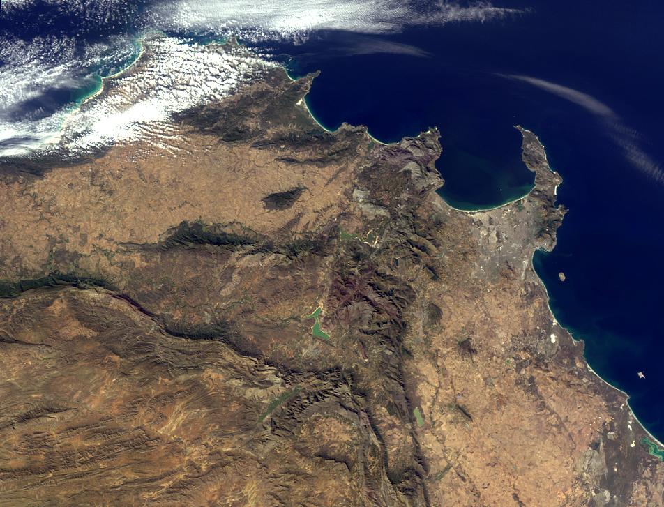
This image was taken by the Multi-angle Imaging SpectroRadiometer (MISR), and represents an area of about 262 kilometers by 200 kilometers. Please note that due North may not be at the top of the page. These questions refer to a landmark, area or province within the pictured region. Please answer the questions below and tell us where on Earth you think the location is. You may use any reference materials you like to answer the quiz.

From the statements below, please indicate which are TRUE and which are FALSE.

  1. Located within the lower third of the image is a dramatic landmark that has lain dormant for thousands of years.
  2. The southwest part of the region pictured overlooks a capital city.
  3. This area was once rich in biodiversity. However, urbanization over the past several decades has reduced the wealth of flora and fauna in the region by nearly 30 percent.
  4. One of the seven natural wonders of the world lies to the northeast of this region, less than a week away by car.
  5. The highest point in this region, located near the peninsula shown in the image, was first successfully climbed in the 16th century, according to records.
  6. The country in which this region is located is home to one of the world’s largest (by volume) rivers.
  7. On the west coast of the region pictured lies a World Heritage Site surrounded by water.

What location is shown in this image?

Quiz Rules

Send us your answers, name (initials are acceptable if you prefer), and your hometown by the quiz deadline of Wednesday, August 3, 2011, using the Quiz answer form. Answers will be published on the MISR web site. The names and home towns of respondents who answer all questions correctly by the deadline will also be published in the order responses were received. The first 3 people on this list who are not affiliated with NASA, JPL, or MISR and who have not previously won a prize will be sent a print of the image.

A new "Where on Earth...?" mystery will appear periodically. The image also appears on the Earth Observatory, http://earthobservatory.nasa.gov/, and on the Atmospheric Sciences Data Center home pages, http://eosweb.larc.nasa.gov/, though usually with a several-hour delay.