Powerful, enhanced analytics bring teams and fans deeper race insights and put them aboard a virtual F50 catamaran
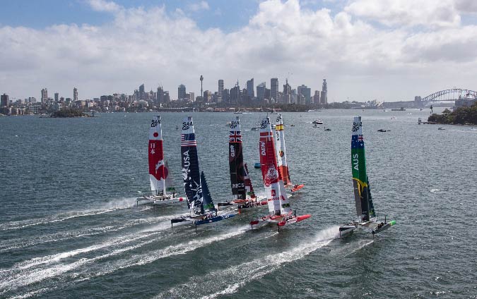
Oracle and SailGP, sailing’s premier racing league, have expanded their successful data analytics platform leading into the second season. SailGP taps Oracle Cloud Infrastructure (OCI) to deliver real-time data to each of the league’s eight national teams as well as to broadcast partners and fans worldwide.
New features added this season will improve team performance and give fans a thrilling crews-eye view of the action.
“Our cutting-edge, global league continues to push the boundaries of what is possible, both on and off the water,” said Russell Coutts, SailGP CEO.
“For Season 2, we’re working on a number of new cloud-based innovations with Oracle to truly enhance the viewer experience and create efficiencies in the way we operate across all aspects of our business.
The results are remarkable, especially on race days which are the ultimate showcase of data, technology and invention.”
Using sophisticated correlation patterns, data enrichment and machine learning, Oracle Stream Analytics makes autonomous decisions based on the 30,000 data points an F50 catamaran sends every second of a race.
Oracle Stream Analytics blends and transforms disparate data into one stream, down from the 10 streams SailGP shared in its first season.
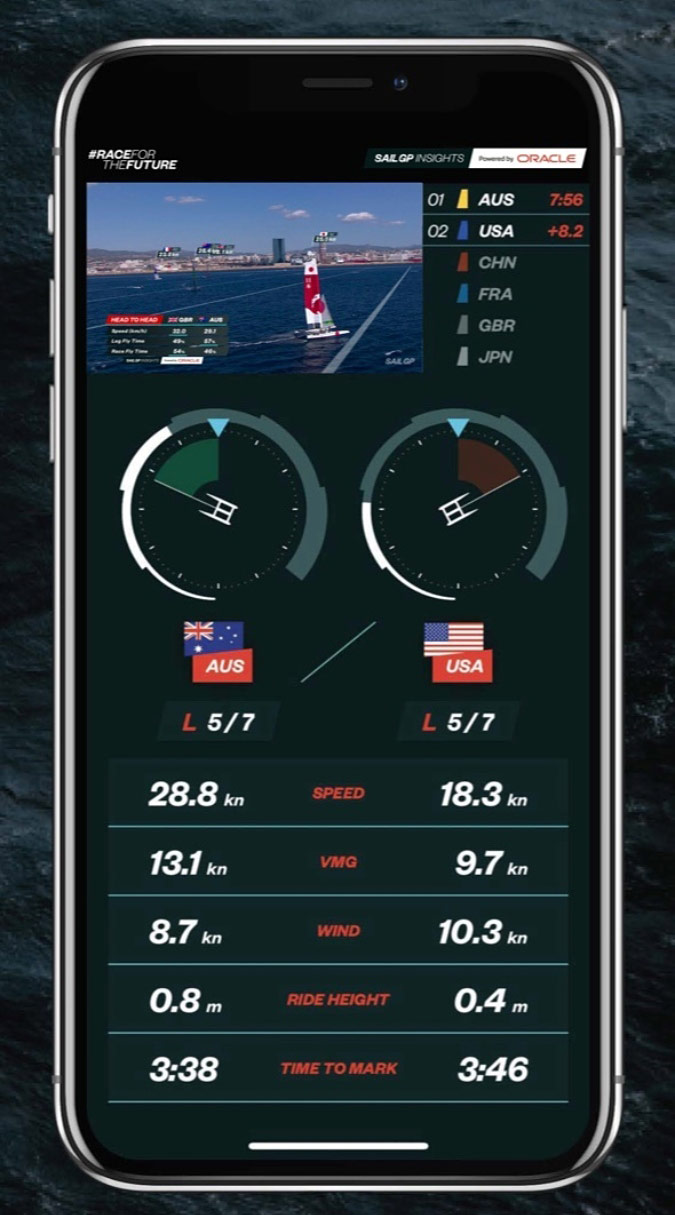
This allows teams to easily customize their data dashboards with relevant tactical information, including open-source data from rival teams, and determine optimal in-race strategies in an instant.
The streamed data is also used to create unique second-screen experiences.
Fans will gain a deeper understanding of the teams’ actions during a race through instantaneous updates of key performance metrics and the enhanced data dashboards on the SailGP app and on SailGP.com.
OCI will deliver the expected 80 billion data requests generated over the course of the eight races to Oracle’s London cloud region for analysis and worldwide distribution, all within two-tenths of a second. Live video and audio feeds taken aboard the F50s are streamed to the cloud region for immediate broadcast, and simultaneously stored in Oracle Autonomous Data Warehouse.
SailGP production teams at league headquarters use this information to create content for distribution across 175 broadcast territories.
Season 2 marks the first time SailGP will coordinate all data and production activities for each race remotely, significantly reducing the costs and the environmental impact of traveling large crews and equipment to each event.
“SailGP is one of the most data-rich sports leagues in the world, and data is in Oracle’s DNA,” said Ariel Kelman, executive vice president and chief marketing officer, Oracle.
“The differentiator in our collaboration this season is the advancements in extracting meaningful information from massive amounts of data and the mind boggling speed at which it’s done. Once other sports organizations realize what SailGP can accomplish, they’ll quickly understand the advantages of having an aggressive and comprehensive strategy for delivering real-time data and insights to both teams and fans.”
Oracle Cloud will also power a new SailGP simulator.
With training restricted to a few days before each event, the simulator allows teammates to virtually race the F50s from any location.
Based on a Dynamic Velocity Prediction Program using Season 1 data, and visualization technology hosted in an Oracle virtual graphics workstation, athletes can take the helm, grinder, wing trimmer or flight controller positions and work through different set-ups and race conditions.
Sailing aficionados will be able to experience the exhilaration of the virtual F50 at future SailGP events where they can compete against a computer generated boat or compete against each other.
SailGP also enters its second season of competition with a renewed relationship with Oracle.
“After a thrilling opening season where we witnessed teams break the 50 knot barrier and set speed records using the real-time data and analytics delivered by Oracle Cloud, I am delighted that SailGP is extending its partnership with Oracle as the league’s global data analytics partner for three more years,” Coutts said.
“Having access to Oracle’s global infrastructure allows us to rapidly process incredibly large amounts of internal data and automate repeatable tasks, improve predictions, and identify issues and performance differences between teams.” “What SailGP and Oracle have accomplished in our short time working together is extraordinary, and this season is set up to surpass that,” Kelman added.
“I look forward to achieving new milestones as we continue on the path we started.”
SailGP Season 2 commences in Bermuda on April 24-25, 2021.
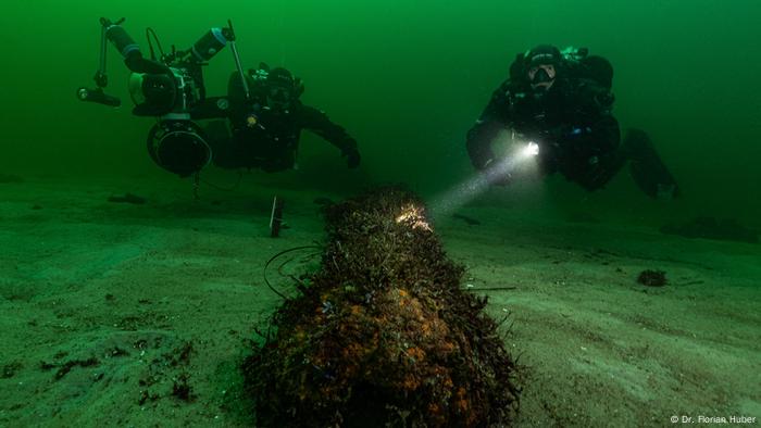
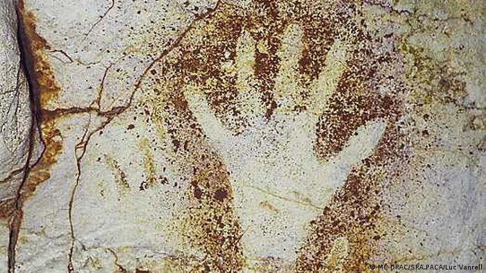
The Cosquer Cave's impressively well-preserved Stone Age paintings were only discovered in 1991. Researchers are always finding new treasures under water.
The research divers in Germany systematically study coastal regions and inland lakes.
They also work around the world, such as in Mexico and Indonesia. Historical sources, like old land and sea maps, or actual eyewitnesses, sometimes lead them to a discovery underwater. Coincidence, however, is the biggest factor in discoveries. GPS cannot help researchers, as it doesn't work underwater.
When the French diving instructor Henri Cosquer discovered in 1985 the access to a flooded cave at a depth of 37 meters (121 feet), during a diving tour in the Mediterranean off the coast of Marseille, he didn't know that it concealed an archaeological sensation.
He and his companions dived down to the entrance of the cave several times over the next few months.
But it wasn't until 1991 that he managed to reach the main cave through a tunnel. It would later bear his name.
The narrow, stone-carved space was completely dry, its walls covered with mysterious prehistoric paintings.
The world's only underwater Stone Age cave
The archaeologists and scientists who later examined the cave found that the drawings were approximately 19,000 to 27,000 years old.
The paintings mainly showed animals — seals, fish, horses, bison, mountain goats, sea birds — that were surprisingly lifelike.
"It's the only underwater Stone Age cave that is known to us to date," explains marine archaeologist Fritz Jürgens from the University of Kiel, who also dives to explore such caves.
"There are particularly good conservation conditions there."
Towards the end of an ice age, this cave, which is about 11 kilometers (7 miles) off the coast in southern France, was used and painted by Stone Age people. But as the polar ice caps thawed, the sea level gradually rose, and the cave entrance was at some point deep under water.
Yet the higher cave itself remained dry.
"That's how these 20,000-year-old and very unique Stone Age cave paintings survived," researcher Jürgens told DW.
"They include a stencil painting of a human hand and the only known Stone Age depiction of a penguin."
The stenciled Stone Age hand in the Cosquer Cave
A replica to secure the prehistoric art
The prehistoric Cosquer Cave is now a protected area open only to researchers.
"The Lascaux caves, for example, were opened to visitors after they were discovered," points out Fritz Jürgens.
"But within 50 years, the visitors' torches and breathing had damaged the works of art so badly that they had to be closed."
Scientists and specialists are currently building an exact replica of the Cosquer Cave for a maritime museum in Marseille.
It is scheduled to be made public in June 2022. The original cave is threatened by rising sea levels, due to climate change.
Shipwrecks are more common
Underwater archaeology is a special method taught at the Institute for Pre- and Protohistoric Archaeology at the University of Kiel, where Fritz Jürgens also completed his training.
Each year, only 10 to 12 students are trained there, and the job opportunities for graduates are limited.
Jürgens' colleague Florian Huber has been working as a professional research diver for many years and dives in the North and Baltic Seas, as well as in large inland lakes in Germany.
As underwater archaeologists, we actually find all kinds of items that were thrown or got into the water at some point, from the Stone Age to World War II," he told DW
"Of course, there are shipwrecks that we find everywhere — in rivers, lakes and seas. And we find submerged settlements that are now under water due to the rise in sea levels."
Excavation of a boat from the 24th-23th century BC, found in Lake Constance
This is an advantage over conventional archaeology, says Jürgens.
"Things are preserved under water that would have long since disappeared on land: all organic materials, for example textiles, leather and wood. On land they only survive in the rarest of cases."
Most finds are accidental
Archaeological research under water also has a clear disadvantage: the GPS system, which has already contributed to spotting many sensational terrestrial finds from the air, does not work at greater water depths.
"It only goes a few centimeters below the surface of the water. Then it breaks off," says archaeologist Huber. "What we use in underwater archaeology to track down finds are side scans or multibeams. We scan the seafloor with acoustic signals. These are reflected, come back to the research vessel and are visualized on the computer as converted signals. And then we can see if there is a wreck on the ocean floor."
Historical nautical charts or logbooks are also used by underwater archaeologists, but most finds are discovered by chance, says Huber.
"New discoveries are always being made underwater, for instance, when new port facilities are built, but also by recreational divers who go down and discover shipwrecks, remains of boats or stakes underwater somewhere."
As German law specifies that all finds must be notified to authorities, researchers can usually quickly secure new archaeological sites.
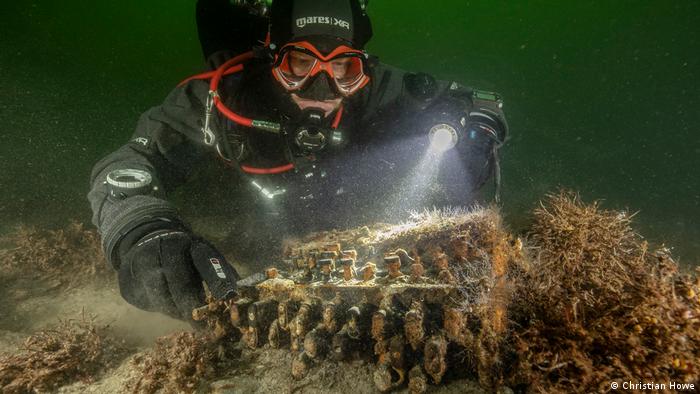
Sensational, surprise discovery of 'Enigma' While recovering an abandoned "ghost net" on behalf of the World Wildlife Fund (WWF) in 2020, a team led by marine archaeologist Dr. Florian Huber discovered a valuable piece of German history: an Enigma, one of the legendary Nazi deciphering machines from World War II.
It had become entangled in the trawl net.
A WWII find while doing environmental work
Underwater archaeologists don't only dive for research purposes.
Huber and his company in Kiel often work for the World Wildlife Fund (WWF).
"Mainly to salvage ghost nets in the Baltic Sea. These are abandoned fishing nets that have been lost but continue to drift in the sea. And fish, birds, whales, seals or turtles can get tangled up in them and die."
It was on one of those missions that Huber's team made a sensational find in 2020, not from the Stone Age, but from the Second World War.
The special typewriter was developed and used by the Nazis to encode and decipher their encrypted messages during WWII. The find attracted international media attention.
For the team of scientists, it was definitely a more valuable discovery than finding ancient gold coins.
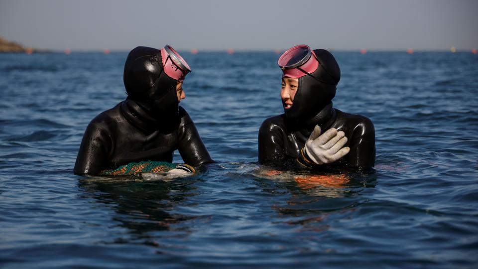
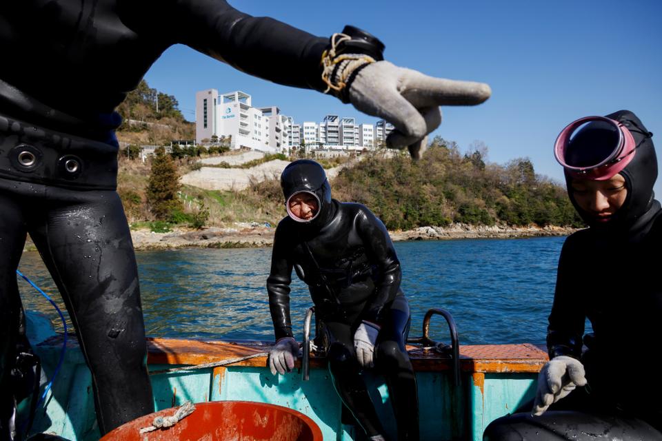
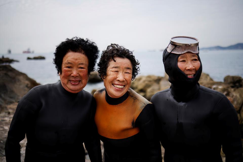
Haenyeo, also known as "sea women", Jin
So-hee, 28, and Woo Jung-min, 35, talk to each other in the sea off
Geoje, South Korea, March 30, 2021. Jin and Woo are some of the youngest members of a centuries-old tradition. (Kim Hong-Ji / Reuters)
Every year the waters are a little less icy – warming as much as 2.6 times more than the world average – changing the undersea habitat and casting doubts on the
future of "haenyeo" or sea women.
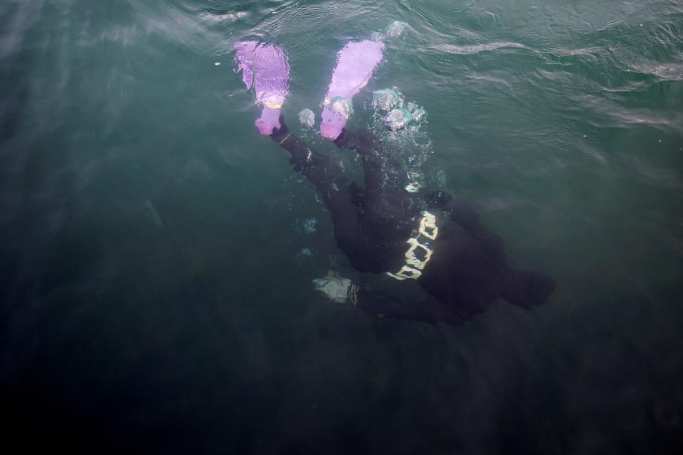
Clad in a black wet suit and pink face mask, Jin So-hee's figure cleanly parts the green-blue water until she abruptly dives below the surface, her purple fins disappearing into the deep.
When she resurfaces a minute and a half later, her gloved hands grip six or seven sea cucumbers, their spiked backs glistening in the sun. "This is the biggest one, what do we do?" she asks her partner, Woo Jung-min. "The boss is going to be mad. He told us to bring in the really big ones today."
Climate change and environmental pollution have made finding enough sea life to harvest more difficult for Jin, Woo, and other South Korean haenyeo, or "sea women".
Jin So-hee, 28, a haenyeo, also known as a "sea woman", dives into the water to harvest sea cucumbers in the sea off Geoje in South Korea, March 31, 2021. Jin says her hopes of making a living as a free diver are now further threatened by climate change. (Kim Hong-Ji / Reuters)
For six years, Jin, 28, has dived the icy seas off the rocky shore of Geoje Island, gathering abalone, conches, seaweed and other marine life by hand to be sold in local markets.
Every year the waters are a little less icy – warming as much as 2.6 times more than the world average – changing the undersea habitat and casting doubt on the future of the haenyeo.
Haenyeo, also known as "sea women" Woo Jung-min, Ko Sun-a and Jin So-hee (R), 28, are seen on a fishing boat after diving in the sea off Geoje, South Korea, March 30, 2021. Jin and Woo are some of the youngest members of a centuries-old tradition.
(Kim Hong-Ji / Reuters)
Jin and Woo, 35, are some of the youngest women following a centuries-old tradition of free-dive fishing without oxygen that has already faced massive upheaval in the face of advances in fishing practices and altered village life in the high-tech world of modern South Korea.
Woo Jung-min, 35, a haenyeo, also known as a "sea woman", displays sea squirts living on a discarded plastic bag that she found under the water while diving in the sea off Geoje, South Korea, March 31, 2021. (Kim Hong-Ji / Reuters)
The vast majority of living haenyeo are now over the age of 70, and in neighbouring Busan, veteran divers told Reuters catches are now a fraction of what was harvested decades ago.
"I’ll continue unless I’m sick, and my wish is this seafood can live until then so that I can continue this work," said 86-year-old Ko Bok-hwa, who has been a diver since she was 13.
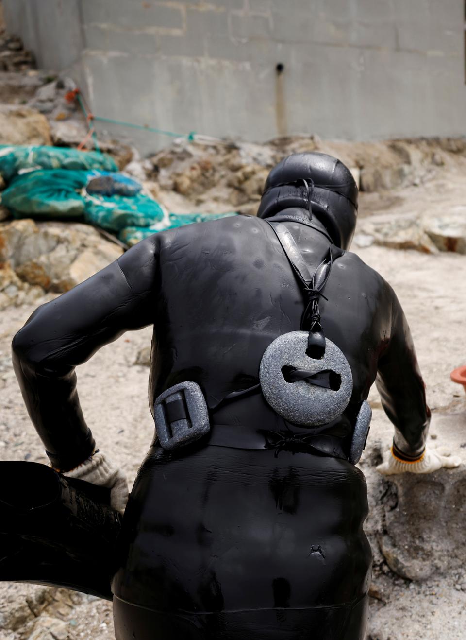
A senior haenyeo, also known as a "sea woman", wears diving weights on the port of Busan, South Korea, April 6, 2021. (Kim Hong-Ji / Reuters)
Jin and Woo have tried to adapt, running a YouTube channel called "Yozum Haenyeo" (Modern Sea Women) to chronicle their lives and work, with their most popular video garnering more than 600,000 views.
But climate change may permanently dash their hopes of spending their lives working as freedivers. "I thought that as long as my body is healthy, I could have been the oldest haenyeo when I'm 90 or 100," Jin told Reuters.
"Now that I think about it, my health is not the only concern.
I’m worried this job will change drastically or even disappear because of climate change."
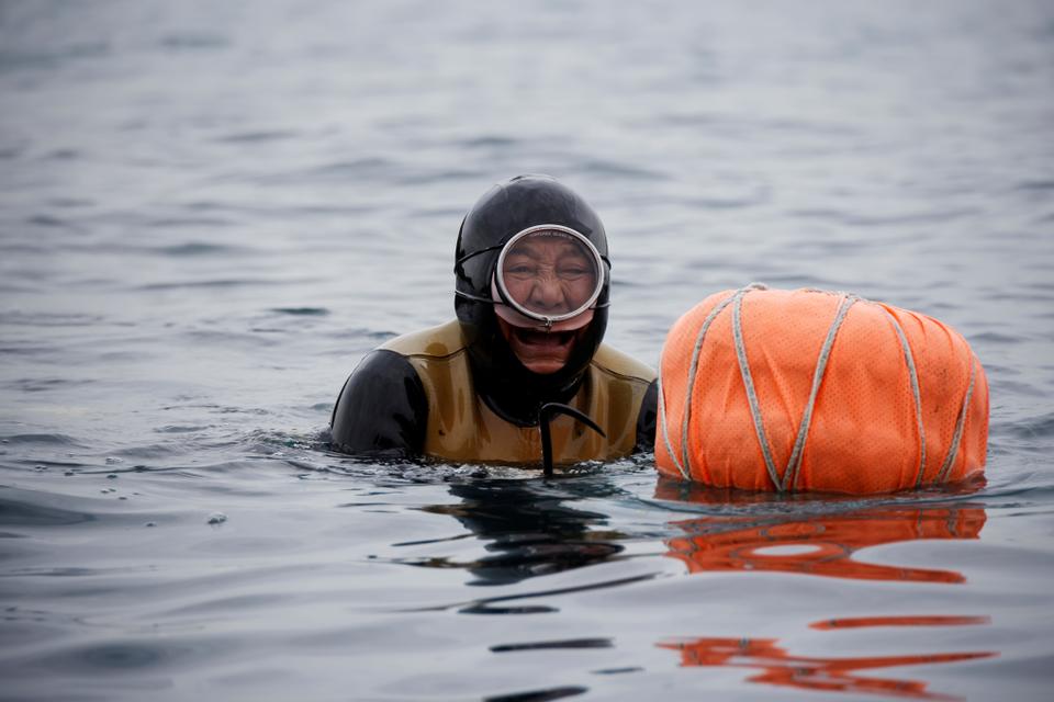
Ko Hwa-ja, 82, a senior haenyeo, also known as a "sea woman", comes up for air as she works in the sea off Busan, South Korea, April 6, 2021. (Kim Hong-Ji / Reuters)
Invasive species, vanishing seaweed
Anecdotal evidence observed by haenyeo on the front lines of the changing environment is confirmed by South Korean scientists seeking to study and protect the country's fisheries. "Climate change caused the change of habitat of sea life and the influx of non-native species," said Ko Jun-cheol, a researcher at the National Institute of Fisheries Science.
Between 1968 and 2017, the sea surface temperature around Korea rose 1.2 Celsius (2.2 Fahrenheit) degrees, compared to a world average of 0.48 Celsius degrees, he said.
Senior haenyeo, also known as "sea women" Jung Sun-ja, 84, Yoon Yeon-ok, 74 and Ko Keum-sun, 69, pose for a photograph after working in the sea in Busan, South Korea, April 6, 2021.
(Kim Hong-Ji / Reuters)
Warmer waters have brought new, subtropical species that have displaced the haenyeo's traditional catch, and changed the seafloor habitat by introducing more stony coral and killing off seaweed forests. Large beds of seaweed have disappeared, replaced by rock-like coralline algae and resulting in the decrease of marine resources.
As recently as the 1990s, scientists would see one or two subtropical species around the islands of Korea's south coast, but a study covering the years 2012-2020 found 85 kinds of subtropical species, accounting for more than half of all sea life in some places, Ko said.
Woo Jung-min, 35, a haenyeo, also known as a "sea woman", poses for a photograph with sea cucumbers that she harvested in the sea off Geoje, South Korea, March 31, 2021. (Kim Hong-Ji / Reuters)
Since 2011, the government has also been working to reverse the ocean desertification caused by climate change.
The Marine Forest Creation Project involves planting new seaweed, which help absorb carbon dioxide from the water, and removing invasive sea urchins that eat the marine plant, said Jeon Byung-hee, an official with the Korea Fisheries Resources Agency's Ecological Restoration Division.
"If seaweeds disappear, it takes away a source of food for animals, spawning grounds, and habitats," he said.
Haenyeo, also known as "sea women", Jin So-hee, 28, Woo Jung-min, 35, and Kim Myung-soon, measure the weight of sea cucumbers that they harvested, at a port in Geoje, South Korea, March 30, 2021. (Kim Hong-Ji / Reuters)
'Really serious'
With less seaweed, which the haenyeo also harvest as food, the women increasingly have to dive deeper, Jin said.
That's more physically challenging, and the women say they have to deal with more pollution as well, further complicating their already dangerous jobs. "I’m finding more golf balls than sea cucumbers now," Jin said.
The haenyeo say the changes are becoming more pronounced every year, which is of particular concern for the dwindling number of young divers hoping to keep the tradition alive - and make enough to keep food on their own tables. "The problems seem very real to us," Woo said after evaluating her diminished catches and tallying up her totals for a recent pay day. "Today, I'm thinking once again, 'This is really serious.'"
With our coastal environments undergoing constant change, Earth observation satellites are being used to better strengthen our knowledge of changing coastlines. Climate change is having an undeniable influence on coastal areas.
A substantial proportion of the world’s sandy coastlines are already eroding owing to increased storm surges, flooding and sea-level rise.
For decades, coastal areas have been subject to intense urbanization and population growth. The European Union coastline is approximately 68,000km long, more than three times longer than that of the United States.
According to the European Environment Agency, almost half of the EU population lives less than 50km from the sea, with the seaside being Europe’s most popular holiday destination.
Understanding the Evolution of Coastal Environments
Coastal erosion is currently observed on many shorelines in Europe and will most likely worsen with rising sea levels. Monitoring coastal movement is key in understanding the evolution of coastal environments and these data can provide fundamental information to regional decision makers.
ESA has been developing an array of products to address these challenges.
Using 25 years of satellite imagery, including data from the Copernicus Sentinel-1 and Sentinel-2 missions, the team has mapped 2,800km of coastline analysed across four nations: the United Kingdom, Ireland, Spain and Canada.
This image shows the annual mean shoreline change in Start Bay, Devon. Areas in red indicate strong erosion, while areas in dark blue show strong accretion.
(Contains modified Copernicus sentinel data (2018-19), processed by ESA/ARGANS Ltd)
Improved Accuracy on the Ground
As part of this project, a special process has been developed and applied to ensure that each pixel from every image has a greatly improved accuracy on the ground, as well as to identify where the coastline is precisely located on a specific date.
The frequent revisit rate of the Sentinel-1 and Sentinel-2 missions has enabled the changes to be observed as well as more permanent and extreme movements due to storm events.These results were then validated by a team of independent scientists from the four nations using results from field observations and local knowledge.
Roberto Díaz Sánchez, from the Directorate-General for the Coast and the Sea at the Spanish Ministry for the Ecological Transition and the Demographic Challenge, commented: “Taking part in this project has enlightened us in coastal surveillance from space. We are now firmly on the road to a new and promising coastal management paradigm, increasing our chances in successfully adapting our coasts to the effects of climate change.”
The current dataset of over 30,000 individual images is now being used to help coastal scientists better understand their local processes.
This image shows the shoreline changes along the coast of Malgrat de Mar, Spain. Areas of erosion between 1994 and 2019 are visible in red, while areas of accretion between 1994 and 2019 are visible in blue. The 1994 coastline data is extracted from US Landsat data while the 2019 data is from the Copernicus Sentinel-2 mission. (Contains modified Copernicus sentinel data (2018-19), processed by ESA/ARGANS Ltd/Landsat
Recognizing Areas of Greatest Change
Mónica López, Spanish delegate at ESA and Centre for the Development of Industrial Technology, said: “I would like to congratulate all of the team for the successful project which focuses on a very important topic for some countries, including Spain. I would like to highlight a very positive aspect of the project which has been the high involvement of final users in all phases of the project, but mainly during validation and testing.”
Koen Verbruggen, director of Geological Survey Ireland at the Department of the Environment, Climate and Communications, added: “The datasets being produced under the ESA-funded Coastal Change from Space project have great potential application in Ireland and come at a very opportune time as we are establishing a National Coastal Change Management Strategy. The coastal change data can help us recognize areas of greatest change, and thus prioritize the allocation of resources at national and local levels.”
Interesting to look at the land reclamation in Sydney Airport over the last 30 years using DEACoastlines
Another impressive example of coastal development visible in the dataset is the construction of the Port of Brisbane at Fisherman Island
The next stage in the journey will be to use these insightful datasets to improve the performance of models and join with other infrastructure and coastal zone morphological knowledge to improve forecasts and enable sensible mitigation strategies to be employed.
On 22 January, the results of the Coastal Change from Space project were presented in an online webinar.
Minimum Requirements for Munitions Detection at Sea
Munitions in the sea pose a risk to the sustainable development of the ocean economy.
In particular, they are a global challenge during the construction of wind parks, pipelines and other infrastructure.
To ensure high-quality performance during the execution of the necessary maritime munitions detection and clearance operations, industry experts and scientists from Germany have defined a set of requirements.
These are particularly important in the detection phase which requires the attention of hydrographic surveyors.
UXO sites in Europe
Safe access to large areas of the seafloor is a prerequisite for offshore economic development.
However, this ability has been compromised by the presence of submerged ammunition around the globe.
Over the past 140 years, ammunition has entered the sea in a variety of entry modes such as naval battles, aerial bombing and mine-laying.
Additionally, large quantities were dumped after the Second World War.
What appears unreasonable today was considered a safe and permanent means of disposing of weapons for many decades, until the practice was eventually outlawed by the London Convention on the Prevention of Marine Pollution by Dumping of Wastes and Other Matter in 1975.
Even today, in times of peace, naval target practice adds to the amount of munitions in the sea.
To this day, more than 1.6 million tons of both chemical and conventional (i.e. explosive) munitions remain in German territorial waters alone.
As an example, Figure above displays a corroded moored mine which was recovered in German waters.
This legacy is not only an obstacle to the offshore construction industry, it also affects sectors like coastal tourism and fishing.
On top of this, it will impede deep-sea mining endeavours in the future.
Ultimately, it may pose a threat to marine life due to gradual leakage of carcinogenic TNT and its metabolites into the seawater.
An international team of scientists working on the multi-year research project ‘Towards the Monitoring of Dumped Munitions Threat’ (MODUM), supported by NATO’s Science for Peace and Security (SPS) Programme have been mapping the ocean floor, locating and monitoring munition dump sites in the Baltic Sea.
The variety of chemical weapons and explosives left over from the Second World War is thought to pose a significant threat to marine life in the region.
Quality Guideline
The challenge of submerged ammunition – also referred to as unexploded ordnance (UXO) – crosses borders and, accordingly, operations concerning their detection and clearance have to be conducted in various judicial areas, some of which are only weakly regulated.
This issue generally concerns exclusive economic zones and international waters.
The absence of an industry standard left the acting stakeholders without guidance regarding best practices, personnel qualifications, technology specifications and requirements for documentation and communication.
This was the reason for the development of a new quality guideline by key German stakeholders from industry, relevant authorities and the scientific community.
Over the course of two years, the ‘Quality Guideline for Offshore Unexploded Ordnance Treatment’ was compiled under the leadership of Leipzig University.
The content of the document was defined, discussed and revised in a series of workshops and expert group meetings.
Experts were given the chance to make annotations to the work in progress twice, which led to the creation of a document that genuinely represents all relevant actors.
At the same time, this process of strong stakeholder involvement was set up to ensure wide acceptance of the finished guideline by the players it affects.
The resulting document covers the entire procedure for offshore munitions treatment which is subdivided into the phases of (I) Desk-based preliminary survey, (II) Technical survey, (III) Investigation of UXO target points, and (IV) Clearance and disposal.
These four phases are displayed in the flowchart in Figure 2.
Phase II: Technical survey, covers the detection of potential UXO.
Figure 2: Procedure for offshore UXO treatment.
Survey Technologies
Magnetic and electromagnetic sensors are the survey technologies that are customarily applied during the execution of a technical UXO survey.
These are supported by additionally deploying side-scan sonar (SSS), multibeam echosounders (MBES) or sub-bottom profilers (SBP).
As each of these sensors has certain shortcomings, the use of a single technology is insufficient.
Magnetic sensors are easily supersaturated in areas where existing infrastructure or a high amount of scrap metal or geologic magnetic anomalies are present.
Electromagnetic sensors suffer from a limited range both vertically and horizontally, thereby rendering their application in larger regions or in areas covered by thick layers of sediment costly.
Both SSS and MBES are suitable during the search for exposed munitions items, but they do not support the detection of any targets that are buried in the sediment.
In addition, they do not allow for the distinction between an UXO and a similarly shaped boulder.
Finally, SBP, with its very limited area coverage, can only act as an additional source of information on items that have already been detected with the help of another sensor.
Consequently, multi-sensor approaches are required. In order to ensure sufficient data quality, the deployment of at least a towed array of magnetic sensors and side-scan sonar is necessary.
Figure 3 exemplifies an area containing numerous suspected UXO target points as measured with magnetometers.
Other sensors may be added to increase information density or to compensate for the shortcomings that are mentioned above.
Some areas may even unify a set of characteristics that make it impossible to guarantee the detection of all relevant munitions items, even if all available technologies were to be deployed.
Critical Survey Requirements
Owing to the large variety of munitions items that may be present and the potential range of their properties, a reference object for the UXO survey needs to be defined.
This is the single most important decision before a technical UXO survey can be conducted.
The reference object is the minimum threat item and is therefore the smallest munitions item that needs to be detected during the survey.
It has to be defined on the basis of information from numerous sources.
Figure 3: Submerged .50 caliber shells from USS Arizona.
First, historical research (which is part of Phase I: Preliminary survey) should provide an indication of the type and degree of contamination that can be expected in the area of interest.
Secondly, a hazard assessment for the surveyed area should provide information on the occupational and economic risks that originate from different types of munitions.
Finally, the technical limitations of the available technologies as laid out above need to be taken into account to ensure that the detection of the reference object is conducted in a manner which is technically feasible.
Other critical technical requirements that need to be defined include the desired detection depth of the minimum threat item below the seafloor, the positioning accuracy and the signal to noise ratio (with an emphasis on magnetic sensors).
All other parameters, such as the line spacing, the along-track-resolution or the height of the towed system above the seabed, are defined thereafter and depend mainly on the specifications of the reference object and the detection depth.
UXO info on nautical charts
Target List and UXO Sign-off Certificate
A technical UXO survey and the subsequent data processing and interpretation commonly result in two main deliverables; the UXO target list and the UXO sign-off certificate.
Both can only be issued by competent personnel, who hold an appropriate certificate of competence for the handling of explosives.
The target list is a directory of all points within the area of interest where the acquired survey data has indicated the presence of munitions.
These points are listed along with relevant information, like water depth, estimated object size and further parameters that are derived from magnetic sensors such as the total field amplitude and the magnetic moment of the measured signal.
The detected target points should then be scrutinized during Phase III: Investigation of target points. If confirmed, munitions should be subjected to Phase IV: Clearance and disposal, such as the items displayed in Figure 4.
As the second output, the UXO sign-off certificate is provided for all those areas that are free of suspected target points.
If the entire survey area is free of target points, a comprehensive sign-off certificate can be issued.
Due to the historical background, this scenario is highly unlikely in European waters and adjacent exclusive economic zones.
t is more likely that only part of the survey area is eligible for sign-off. Either way, the limitations of the sign-off certificate, such as the specified reference item, detection depth, time of the survey and the utilized survey technologies, need to be clearly communicated.
Finally, it should be noted that a UXO sign-off must be based on the results of a technical UXO survey.
A desk-based risk assessment cannot replace a qualified technical survey.
Figure 4: Salvaged munition items that are save to handle. (Courtesy: Henrich Hirde)
Conclusion
As submerged ammunition continues to present an obstacle to development, the new quality guidelines inform employers, authorities, survey companies and UXO clearance specialists alike on requirements for performing the detection and clearance of munitions in the sea.
While the document caters to the German legal specificities, most of its content is applicable to any offshore location and even to inland bodies of water.
The limitations of available technologies make the technical UXO survey a particularly intricate task. In order to collect an adequate amount of data, numerous sensors such as magnetometers and SSS need to be combined, with the aim of detecting at least a previously defined reference object.
This results in the generation of a target list and a UXO sign-off certificate, both of which are of paramount importance to the mediation of a hazard that affects the ocean economy and the marine environment alike.
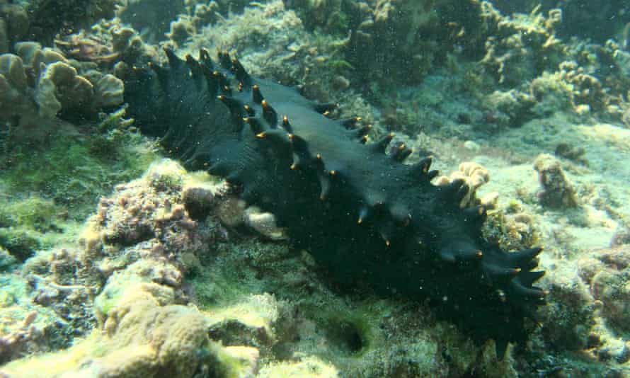
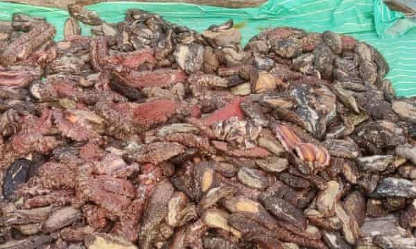
A sea cucumber in a marine protected area in Lakshadweep union territory, a group of small islands off the south-west coast of India. Photograph: Jafer Hisham
Overfishing and smuggling of this crucial animal are affecting biodiversity and the livelihood of local fishers in Sri Lanka
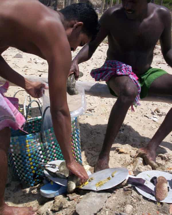
It’s after sunset in Jaffna when Anthony Vigrado dives into the waters of Palk Bay, scanning the seafloor to collect what seems to be prized treasure.
What he comes back with are sea cucumbers – long, leathery-skinned creatures that are increasingly valuable and the source of his income for the past 12 years.
But after a 10-hour search, his harvest is only a fraction of what it used to be, as the shores of northern Sri Lanka and southern India have become a prime spot for exploitation.
“Illegal fishermen are coming across our borders and collecting sea cucumbers in places where we dive normally. We are losing our income and our riches to them,” the 31-year-old fisher says.
Sea cucumbers are echinoderms with soft, tubular bodies resembling their namesake vegetable.
As they feed on the detritus in sediment, they help to recycle nutrients and excrete nitrogen, ammonia, and calcium carbonate, key ingredients for coral reefs.
Their feeding also helps to slow the oceans’ acidification from human activity.
Sea cucumbers are in great demand in China and south-east Asian countries, where they are regarded as a culinary delicacy and used in traditional medicines.
They are usually eaten in dried form – known as bêche-de-mer or trepang.
They are also mistakenly considered to be an aphrodisiac by some, especially in China (as well as their penile shape, they can also stiffen and expel their guts as a defence mechanism).
This has fuelled an incredibly lucrative trade in the endangered animals, one that has grown steadily in recent decades.
Over the years, Palk Bay and the Gulf of Mannar have witnessed extreme overfishing of sea cucumbers. For the most expensive species, global populations have fallen by more than 60%.
Divers with their catch of sea cucumbers from the Gulf of Mannar.
Photograph: Sajan John
Now the small tropical island is a growing hotspot for illegal smuggling and poaching.
Like Vigrado, more than 10,000 fishing families along the northern coasts of Sri Lanka are worried about the state of the fishery.
“Populations are declining due to overfishing. It affects biodiversity, and it also affects the livelihood of the coastal fishers who depend on this activity,” says Chamari Dissanayake, a senior lecturer of zoology at Sri Lanka’s University of Sri Jayewardenepura.
With illegal boats destroying the equipment of local fishers to catch the sea cucumbers, Vigrado says some have killed themselves after being unable to repay loans.
“Their entire investment was being damaged by this,” he says.
“These boats do not care about them, and when they cross into our waters, it’s a complete loss for us fishermen.”
AM Stanny Lambert, a 31-year-old freediver from Vankalai in Mannar, says he is saddened and angered by the amount of illegal activity. “It’s unethical and we’re stuck, because they’re collecting everything before we do,” he says, noting that he and his father have been licensed fishers for sea cucumbers for 11 years, and the family’s sole earners.
Most criminal activity reported takes advantage of differing regulations between the neighbouring countries.
While Sri Lanka issues fishing licences and allows exports of sea cucumbers, India has had a total ban on all trade in the animals since 2001.
Illicit sea cucumbers are therefore either caught in India and smuggled into Sri Lanka, where they are exported legally to south-east Asia, or exported from India under false labelling.
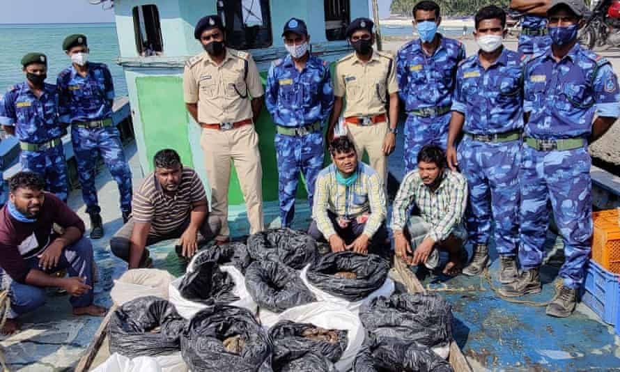
The marine wildlife protection force in India’s Lakshadweep islands with a seizure of 486 dead sea cucumbers last month.
Photograph: Lakshadweep Forest Department
Last August, three men were caught smuggling nearly 1,000kg of sea cucumber – valued by the Indian Coast Guard at £500,000 on the international market – from Tamil Nadu in India to Sri Lanka through the Gulf of Mannar, with a similar case last month.
“If you have a legal market in that kind of way in proximity to an illegal market, the legal market becomes a huge source for fish laundering,” says Teale Phelps Bondaroff, director of research at OceansAsia, whose recent report maps the arrests and seizures of sea cucumbers in the two countries.
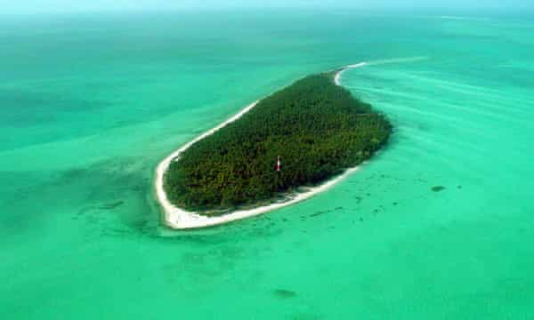
According to OceansAsia, organised sea cucumber crime is spreading further away from Palk Bay and the Gulf of Mannar into the underexploited areas of the Lakshadweep union territory, an archipelago off the south-west coast of India.
In the largest seizure of its kind, a tipoff from local fishers in February 2020 led to authorities finding 1,716 sea cucumbers worth nearly £420,000 hidden in coral reefs near Suheli, an uninhabited island.
“Resource depletion could be a major reason why these people are searching for new grounds. Lakshadweep is much more pristine, so that may be the reason why traders are moving there,” says Sajan John, head of policy and marine projects at the Wildlife Trust of India.
A haul of 416 dead sea cucumbers seized from an uninhabited island off Perumal in Lakshadweep last month.
Photograph: Lakshadweep Forest Department
Realising the severity of increasing levels of crime around the trade, local authorities have stepped up their response, says John.
“The people of Lakshadweep understood the importance of sea cucumbers because their livelihood is largely depending on fisheries. When sea cucumbers are affected, other fisheries are affected,” says Sivakumar Kuppusamy, a scientist at the Wildlife Institute of India.
But as the bulk of the illicit trade continues to be smuggled into Sri Lanka, Kuppusamy agrees that while stopping the criminal supply chain is crucial, helping those fishers taking sea cucumbers illegally to appreciate the importance of the animals is also crucial to their protection. “We have to convince them of the ecological role. If there are no sea cucumbers, then you’re endangering the sea,” he said.
“That’s when they start to realise their livelihoods and their kids’ future will be affected. “Breaking that [illegal supply] chain and convincing the fishermen – we have to do both. Otherwise this trade will continuously grow.”

 Haenyeo, also known as "sea women" Woo Jung-min, Ko Sun-a and Jin So-hee (R), 28, are seen on a fishing boat after diving in the sea off Geoje, South Korea, March 30, 2021.
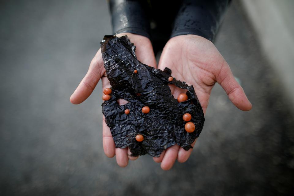
 Senior haenyeo, also known as "sea women" Jung Sun-ja, 84, Yoon Yeon-ok, 74 and Ko Keum-sun, 69, pose for a photograph after working in the sea in Busan, South Korea, April 6, 2021.
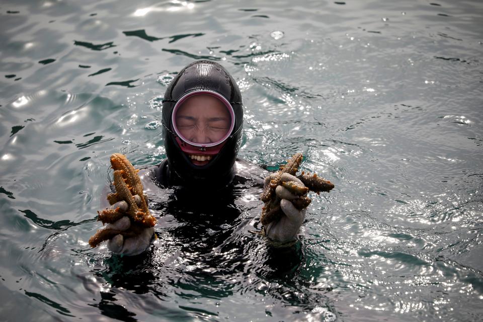 Woo Jung-min, 35, a haenyeo, also known as a "sea woman", poses for a photograph with sea cucumbers that she harvested in the sea off Geoje, South Korea, March 31, 2021.
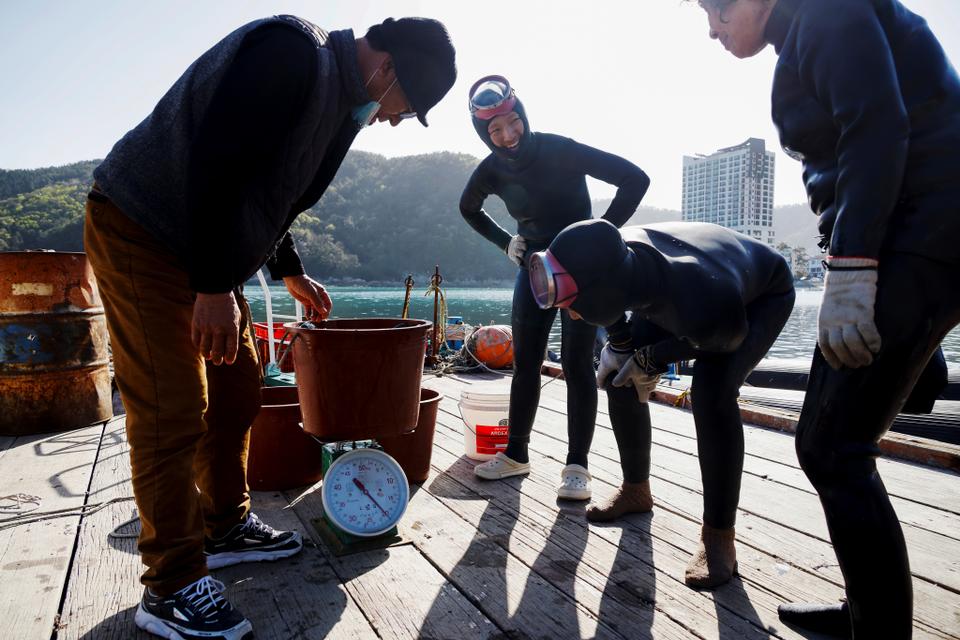 Haenyeo, also known as "sea women", Jin So-hee, 28, Woo Jung-min, 35, and Kim Myung-soon, measure the weight of sea cucumbers that they harvested, at a port in Geoje, South Korea, March 30, 2021.
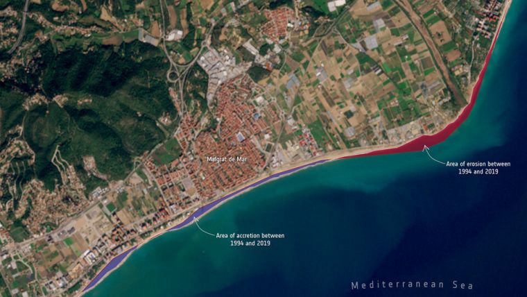
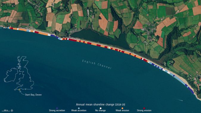
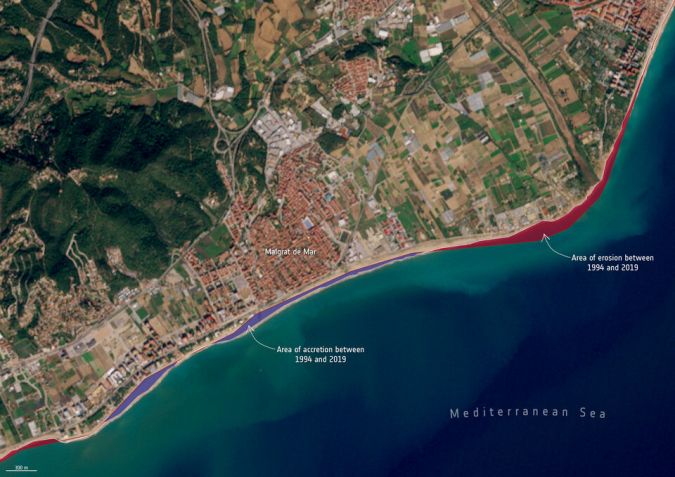
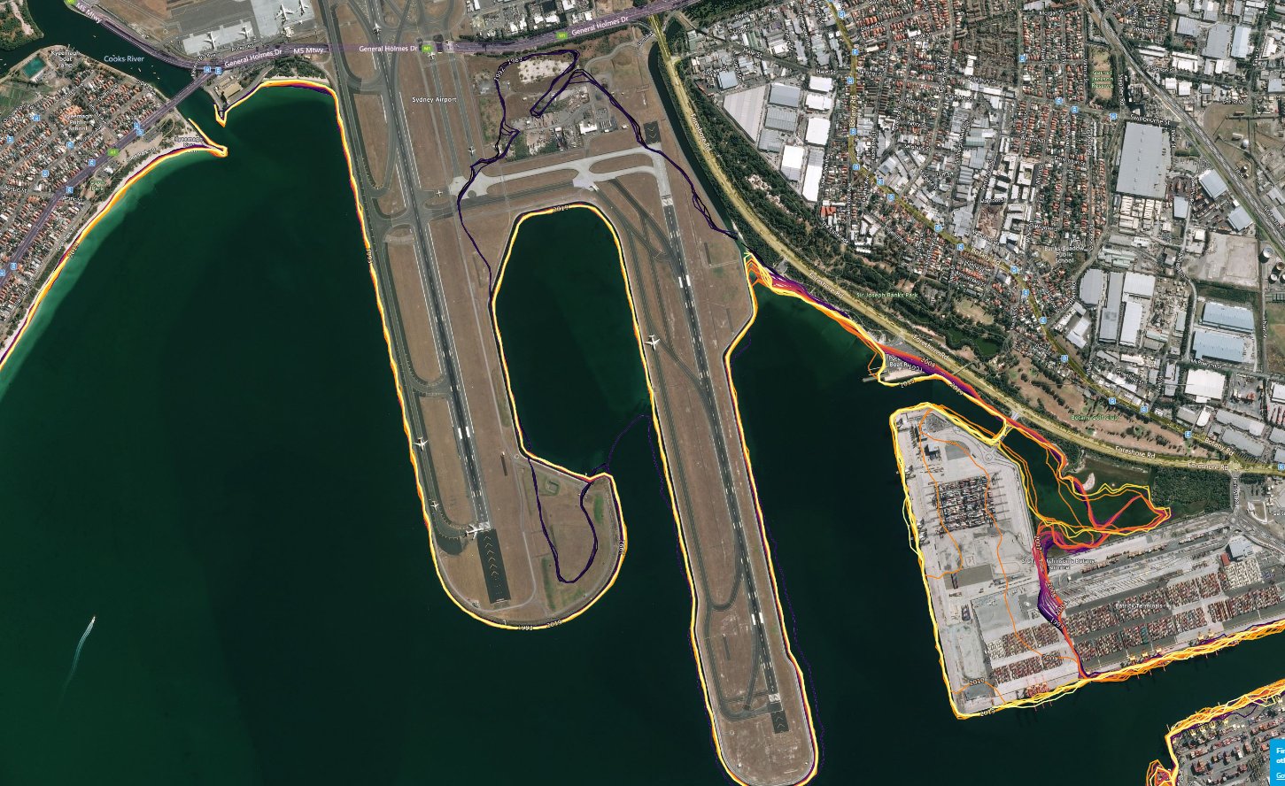

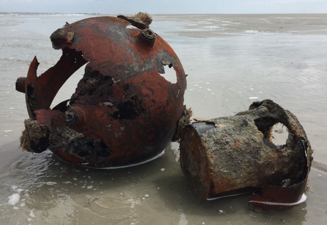

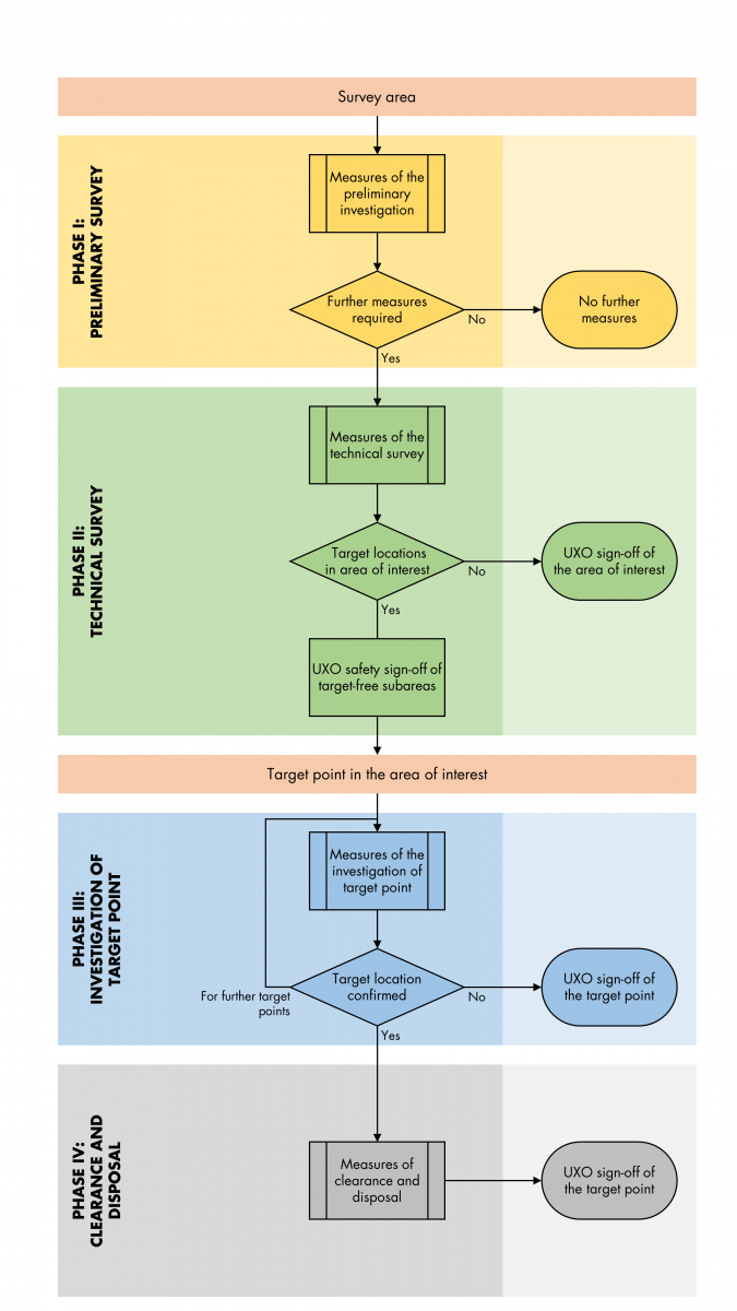
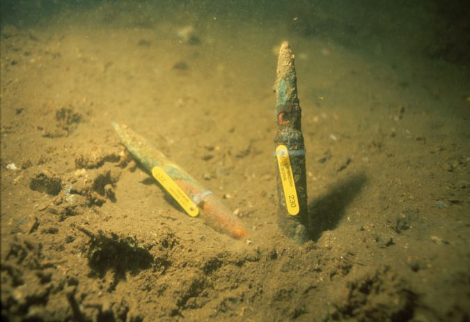 Figure 3: Submerged .50 caliber shells from USS Arizona.

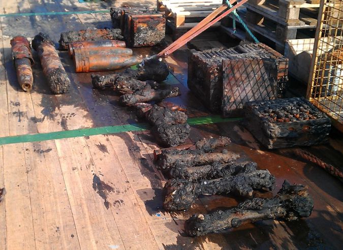 Figure 4: Salvaged munition items that are save to handle. (Courtesy: Henrich Hirde)