Svalbard, the archipelago on top of the world in the Arctic Ocean, is increasingly a hotspot of geopolitical tensions.
Photo: Forsvaret From The Arctic Institute by Bart van der Wall, Researcher Strategic Foresight & Intelligence at the Clingendael Institute.
A swarm of drones intruding into Poland and fighter jets violating Estonian airspace; recent incidents demonstrate how Russia is escalating its aggression against NATO and its European allies in particular.
Understandably, much attention is now given to strengthening NATO’s eastern flank. 1)
However, allies should be equally wary of another challenge up north.
Silent geopolitical hotspot
Svalbard, the archipelago on top of the world in the Arctic Ocean, is increasingly becoming a hotspot of geopolitical tensions.
The international status of the archipelago was settled in the Svalbard Treaty of 1920. 2)
Norway’s conflict mitigation approach since then has been based on the assumption that Russia, despite its increasingly threatening diplomatic language and military posture, still seeks to maintain the status quo in the Arctic. 3)
In recent years, however, Russia has increasingly and openly challenged this status quo.
Through a surge in patriotic activities, escalating media narratives framing Norway as aggressor and with disinformation campaigns, Russia is fueling a dangerous narrative.
The Kremlin also increases diplomatic pressure on Norway by questioning the legal status of the islands.
Furthermore, a build-up of forces in the region, military exercises in the Barents Sea and covert operations targeting Svalbard all suggest that the Russian threat is as serious in the High North as it is on the Eastern flank.
While the Svalbard Treaty grants Norway “full and absolute” sovereignty over the archipelago, it puts severe limitations on Norway’s ability to exercise that sovereignty.
For example, article 9 of the Treaty forbids Norway to build any fortifications or naval bases on the islands for military purposes.
Additionally, the Treaty grants non-Norwegian citizens of the signatory countries free access to Svalbard and the right to engage in economic activities on the islands.
These concessions are reason for some scholars to consider the Treaty as a vassalage treaty, that forces Norway to act as a vassal state to the signatory powers. 4)
One power in particular has been assertive in exercising its right of access to Svalbard.
In 1927 the Soviet Union bought the town of Pyramiden, named after a pyramid-shaped mountain from which coal was mined.
Five years later the Russian company Arktikugol took over a second coal mine from the Dutch Spitsbergen Company along with a small settlement called Barentsburg.
Before 2022, a slight majority of residents in Barentsburg were Ukrainian, many of whom originally came from the Donetsk and Luhansk regions.
Today, almost all Ukrainians have left town.
Some went to Longyearbyen or the Norwegian mainland, others returned to Ukraine to defend their homeland.
Russian patriotism
Tensions within the remaining community on Svalbard are running high.
A former Russian resident told the Barents Observer 5) that the war in Ukraine has turned Barentsburg into “some kind of grey closed and aggressive swamp.” Another resident describes how the last couple of years resentful sentiments have fostered among the Russian residents on Svalbard: “The people are angry.
One can now really observe people harden in real time.” Contacts between the Russian towns and the capital of Longyearbyen have also cooled down to a minimum.
“Every morning, I still send my readings and predictions to Barentsburg,” the meteorologist at Longyearbyen airport told Geographical, 6) but “I never get a reply.”
It’s no exaggeration to say that the Russian community on Svalbard appears to be radicalizing to dangerous levels.
Since the war, patriotic symbolism has been popping up everywhere.
In the harbor of Pyramiden, the Norwegian flag was taken down and replaced by the Soviet flag, dusting off a faded memory of the town’s glory days. 7) Meanwhile, a visiting Russian bishop together with the CEO of Arktikugol raised a giant Orthodox cross 8) on the mountainside, decorated in black and orange colors, the ones used to mark Russian military vehicles in Ukraine.
In Barentsburg, a militaristic parade was held to commemorate the Russian Victory Day for the first time with trucks, snowmobiles and even a helicopter, violating Norwegian regulations. 9) This parade, which did not take place on the islands before 2022, has become a recurring event that appears to be closely linked to the current Russian war effort in Ukraine. 10)
A recent discursive study 11) of Russian media narratives reveals that Russian media over recent years shifted its focus from emphasizing cooperation between Russia and Norway to highlighting negative developments, such as incidents between Russian fishing trawlers and the Norwegian Coast Guard.
Nostalgia about the Soviet past is also reinvoked while Norway is represented as a criminal and aggressive actor striving for complete control over the archipelago.
The study also highlights an alarming similarity between Russian narratives about Svalbard and those about Ukraine preluding the war.
Federal media frame Russia as a victim, accusing Norway of seriously violating the rights of Russian citizens on Svalbard.
This is accompanied by the spread of misinformation and conspiracy theories.
For example, in 2023, Russian outlets reported that the United States was building a secret bio-lab on Bear Island 12) with the goal of unleashing a virus in Russia, echoing similar stories about American bio-labs in Ukraine.
Within this context of misinformation, it would be easy for the Kremlin to justify launching a special military operation on Svalbard under the guise of protecting Russian minorities, recycling the same narrative it used to justify its aggression against Ukraine.
Critical infrastructure
Historical and symbolic value is likely not the only reason behind Russia’s interest in Svalbard.
The archipelago’s geographical position makes it an incredibly valuable piece of land.
The archipelago is ideal for some types of scientific observations such as monitoring radioactivity. 13) More importantly, Svalbard is one of the few suitable locations to downlink data from satellites that orbit the Earth from pole to pole during every trip.
Therefore, Svalbard has become a central hub for critical satellite infrastructure.
SvalSat, Svalbard’s largest ground station, operates over 150 antennas on the islands, more than any other commercial station in the world.
Alternative locations in Greenland, Alaska or Antarctica offer less connectivity and are difficult to maintain due to harsher weather conditions. 14)
 ESASvalsat is the largest commercial ground station on earth and the only viable location to downlink data from satellites at every orbit.
In November 2021, Russia explicitly stated that it considered Norwegian satellite infrastructure on Svalbard a violation of the Svalbard Treaty due to its dual-use potential.
However, the scientific and military uses of satellite data are in practice difficult to separate and sit in a grey area.
For example, During the Iraq War, Svalbard ground stations contributed to American military missions by providing data on sandstorm forecasts. 15)
Furthermore, the United States Coast Guard uses the Svalsat ground station for its operations. 16)
Russia claims that downlinking this type of data on Svalbard is a violation of the Svalbard Treaty.
In January 2022, shortly before the invasion of Ukraine, one of the two fiber optic cables connecting Svalbard with mainland Norway suddenly lost its signal.
Suspicions of sabotage were raised immediately when it was revealed that Russian trawlers navigated over the cable around the time it was damaged.
However, authorities never found evidence of a human cause.
Since special equipment had to be shipped from Norway to repair the damage, it took 11 days before the connection was restored.
According to a Norwegian Institute of International Affairs (NUPI) report, 17) if both cables had been cut, “most of the communication between Svalbard and the outside world would be lost.” Whether Russia was involved or not, the incident demonstrated Svalbard’s vulnerable position.
The opening salvo of Russia’s war against Ukraine did not consist of bullets: it started with a large scale cyber-attack on the KSAT satellite network, in which SvalSat acts as a central hub without which satellites are just “space junk” according to KSAT Ceo Rolf Skatteboe. 18)
The cyber-attack not only disrupted the communications of the Ukrainian army, it also brought 5800 wind turbines in Germany to an abrupt halt because they used the same network. 19)
Modern satellites host a blend of military and civilian users, and dramatic disruptions can occur when critical infrastructure like that on Svalbard is sabotaged.
Military build-up
In addition to its satellite infrastructure, Svalbard is strategically important due to its proximity to two critical naval choke points, namely the Bear Gap, between Svalbard, Bear Island and the Norwegian mainland, and the GIUK-gap, between Greenland, Iceland, and the United Kingdom.
These waterways connect the Arctic Ocean to the Atlantic and formed crucial supply lines from North America to Europe during both World Wars.
Controlling Svalbard could allow Russia to deny NATO naval access to both gaps during a potential conflict and disrupt transatlantic movements. 20)
While the Svalbard Treaty prevents Norway from maintaining a security presence on the archipelago, Russia has mustered a significant military force merely 260 kilometers from Svalbard’s shores.
Nagurskoye air base is Russia’s northernmost military base, located on the Russian Frans Josef Land archipelago northeast of Svalbard.
Since 2015, Russia has been transforming the old Soviet base to increase its capabilities.
An extension of the runway was completed in 2020 so that the base can accommodate any military aircraft, including MiG-31 and Su-34 fighterjets and Il-76 heavy transporters.
Furthermore, Russia has stationed Bastion missile systems on the islands, the same system it used to launch hypersonic missiles against Ukraine. 21)
Nagurskoye has transformed from a seasonal military outpost to a base that is operational year-round, occasionally hosting Russia’s long-range bombers and serving as base camp for large-scale exercises.
The Russian navy has also increased its activities in the Barents Sea.
Since 2022, Russia announced a total of 30 NOTAMs (Notice to Airmen, official announcements that a military exercise or weapon test will take place) in the region.
A worrying trend can be observed in the geographical pattern of these events.
Whereas before the full-scale invasion of Ukraine, Russian northern sea and air exercises were largely focused on the Norwegian sea, after 2022, the location of exercises shifted to the Barents Sea.
This might indicate a change in political signaling, a lack of capacity and resources, or a change in geostrategic objectives.
In either case, there is clear evidence that Russian exercises are, more than before, taking place in the immediate surrounding of the Svalbard archipelago.
 Areas in which Russian military exercises or weapon tests took place since the invasion of Ukraine in 2022. 22)
Some reports suggest that the Zapad military exercise in 2017 included a simulation of an amphibious assault on Svalbard. 23)
In 2019, Russian newspaper Novaya Gazeta claimed that it identified several Chechen members of the Spetsnaz, Russian special forces, on Instagram photos. 24)
However, Norwegian officials stressed that there was no evidence to validate this information.
In April 2020, the Russian military conducted an airborne landing exercise using paratroopers on Franz Josef Land. 25)
A specialized unit, equipped with oxygen masks and gear to withstand the extreme cold, jumped out of an Il-76 transport aircraft from the staggering height of 10,000 meters.
This marked the first operation of its kind in Arctic conditions.
The paratroopers stayed on the island for 3 days before moving to their extraction point.
The role of NATO
Russia has been challenging Norway’s sovereignty over Svalbard for years now, not only indirectly through domestic media and military exercises, but also directly through official channels.
In 2020, Russian foreign minister Sergey Lavrov sent a threatening letter to his Norwegian counterpart, writing: “Svalbard was transferred to Norway under certain conditions.
In the last few years, Oslo has been practically violating the treaty’s provisions which set out specific obligations of Norwegian authorities in this regard.
Such an approach is inadmissible and we do not accept it.”
In December 2024, a spokesperson of the Russian Foreign Ministry 26) warned that “Oslo and its allies are actually dragging Svalbard into the conflict in Ukraine” by suggesting that the islands fall under NATO’s responsibility.
She further described the archipelago as “a testing ground for dual-use products and technologies.” In March, Russian officials in a working meeting with the Norwegian ambassador repeated the claim that Norway was violating the Svalbard Treaty and thereby undermining “the international legal basis of the archipelago’s status.” 27)
This direct questioning of the legal status of Svalbard opposes the previously widely held belief that Russia is content with the status quo.
In contrast with other theaters, Russia has the means to take initiative against NATO in the High North.
In a RUSI paper, 28) Kaushal et al.
do not offer a positive outlook for a potential clash between NATO and Russian forces in the Arctic seas.
Their model predicts that NATO would sustain significant losses in the first stages, especially in a scenario in which NATO is forced to take on a reactive and defensive posture.
The authors conclude that “Russia can dominate all likely scenarios, including limited skirmishes,” thanks to the extensive anti-access area denial (A2/AD) capabilities, including both anti-air and anti-ship missile systems, that it has stationed in the Arctic region.
Testing the alliance
Norway’s response to the Russian challenge consists of a mixture of deterrence and reassurance. 29) Norway emphasizes that Svalbard falls under NATO’s Article 5 protection but treats the practical defense of the archipelago as a national responsibility to avoid provoking Russia.
However, the Russian threat stretches beyond Norwegian security.
While Svalbard might be geographically remote, in today’s interconnected world an assault on the islands would have far-reaching consequences for the entire alliance.
Critical infrastructure throughout Europe can be impacted if satellite connection on Svalbard is disrupted.
Secondly, Russian control over the islands would worsen NATO’s security situation on its Northern flank by serving as a base from which Russia could prevent allied ships from entering the critical GIUK- and Bear-gaps.
A successful Russian operation on Svalbard would pose a serious challenge to NATO’s political unity.
After the mixed signals coming from president Trump about his interest in European security, Putin might be looking to create a perfect storm for the Alliance.
If the Kremlin is truly set on further testing NATO’s resolve, launching a special military operation against Svalbard is a tempting way to do so.
The narrative of protecting Russian minorities is already in place.
The Russian military can execute an airborne landing from Nagurskoye base in a matter of hours.
Without armed forces stationed on Svalbard, and with the closest Norwegian base more than twice as far away, the invaders would face little initial resistance.
In an operation mirroring the annexation of Crimea, unmarked Russian special forces could take control of the archipelago before NATO can respond.
Norway and NATO would then find themselves confronted with a very difficult choice: escalate by launching a counterattack, with the risk of significant losses, or sit idle when a number of allies urge for diplomatic dialogue with Russia, greatly damaging the alliance’s deterrence.
References[−]References↑1 NATO (2025) Strengthening NATO’s eastern flank, 23 October 2025,
https://www.nato.int/cps/en/natohq/topics_136388.htm. Accessed on 27 October 2025
↑2 Alina Bykova (2024), Svalbard’s Extractive Economy: Past, Present, Future, The Arctic Institute, 25 June 2024,
https://www.thearcticinstitute.org/svalbards-extractive-economy-past-present-future/. Accessed on 27 October 2025
↑3,↑29 Bjørn Olav Knutsen (2024), War in Europe, but Still Low Tension in the High North? An Analysis of Norwegian Mitigation Strategies, Arctic Review on Law and Politics 15, 25-46,
https://arcticreview.no/index.php/arctic/article/view/5065/9614↑4 R. Berg (2023), The Genesis of the Spitsbergen/Svalbard Treaty, in: Howkins, A., Roberts, P., eds. The Cambridge History of the Polar Regions, Cambridge: Cambridge University Press
↑5 Thomas Nilsen (2023), Barentsburg: “Everyone was told to stop posting opinions about the war”, The Barents Observer, 11 May,
https://www.thebarentsobserver.com/democracy-and-media/barentsburg-everyone-was-told-to-stop-posting-opinions-about-the-war/128194. Accessed on 27 October 2025
↑6,↑7 Boštjan Videmšek (2024), Arctic geopolitics: the Red Flag flying in Svalbard, Geographical, 27 September,
https://geographical.co.uk/geopolitics/arctic-geopolitics-the-red-flag-flying-in-svalbard. Accessed on 27 October 2025
↑8 Thomas Nilsen (2023), Bishop Iyakov, who backs Putin’s war, raised giant cross at Svalbard without Norway’s knowledge, The Barent Observer, 12 August,
https://www.thebarentsobserver.com/arctic/bishop-iyakov-who-backs-putins-war-raised-giant-cross-at-svalbard-without-norways-knowledge/118362. Accessed on 27 October 2025
↑9 Elizaveta Vereykina (2024), We are not disputing this decision. The penalty will be paid”. Russian company fined for a helicopter flight on Svalbard, The Barents Observer, 7 February,
https://www.thebarentsobserver.com/news/we-are-not-disputing-this-decision-the-penalty-will-be-paid-russian-company-fined-for-a-helicopter-flight-on-svalbard/111336. Accessed on 27 October 2025
↑10 Thomas Nilsen (2025), Militarized memory: Kremlin-orchestrated ‘Immortal Regiment’ rally on Svalbard, The Barents Observer, 10 May,
https://www.thebarentsobserver.com/news/militarized-memory-kremlinorchestrated-immortal-regiment-rally-on-svalbard/429583. Accessed on 27 October 2025
↑11 Anna Obukhova (2024), Svalbard through the prism of Russian media: a discourse and cognitive perspective, The Arctic University of Norway,
https://munin.uit.no/handle/10037/33510?locale-attribute=en. Accessed on 27 October 2025
↑12 Ben Taub (2024), Russia’s Espionage War in the Arctic, The New Yorker, 9 September,
https://www.newyorker.com/magazine/2024/09/16/russias-espionage-war-in-the-arctic. Accessed on 27 October 2025
↑13 Astri Evardsen (2025), Norway to Monitor Airborne Radioactivity in Svalbard, High North News, 26 September,
https://www.highnorthnews.com/en/norway-monitor-airborne-radioactivity-svalbard. Accessed on 27 October 2025
↑14,↑15 Sarah Scoles (2025), A Powerhouse of Global Satellite Infrastructure: Norway?, Undark, 19 March,
https://undark.org/2025/03/19/global-satellite-infrastructure-norway/. Accessed on 27 October 2025
↑16,↑18 Gregory Falco, Nicolò Boschetti & Loannis Nikas (2024), Undercover Infrastructure: Dual-Use Arctic Satellite Ground Stations, Centre for International Governance Innovation, 8 April,
https://www.cigionline.org/publications/undercover-infrastructure-dual-use-arctic-satellite-ground-stations/. Accessed on 27 October 2025
↑17 Niels Nagelhus Schia, Ida Rødningen & Lars Gjesvik (2023), The subsea cable cut at Svalbard January 2022: What happened, what were the consequences, and how were they managed?, Norwegian Institute of International Affairs, 2 January.
https://www.nupi.no/en/publications/cristin-pub/the-subsea-cable-cut-at-svalbard-january-2022-what-happened-what-were-the-consequences-and-how-were-they-managed. Accessed on 27 October 2025
↑19 Christopher Tredger (2025), Space industry has direct impact on cyber security, crisis management, ITWeb, 15 April,
https://www.itweb.co.za/article/space-industry-has-direct-impact-on-cyber-security-crisis-management/KA3WwqdzxKj7rydZ. Accessed on 20 October 2025
↑20 Andreas Østhagen, Otto Svendsen, & Max Bergmann (2023), Arctic Geopolitics: The Svalbard Archipelago, Center for Strategic & International Studies, 14 September,
https://www.csis.org/analysis/arctic-geopolitics-svalbard-archipelago. Accessed on 27 October 2025
↑21 Sofiia Syngaivska (2024), Ukrainian Intelligence Is Seeking Crucial Details about the Bastion System in Crimea, Defense Express, 10 April
https://en.defence-ua.com/news/ukrainian_intelligence_is_seeking_crucial_details_about_the_bastion_system_in_crimea-10124.html. Accessed on 27 October 2025
↑22 Kristian Åtland, Thomas Nilsen, Torbjørn Pedersen (2024), Bolstering the Bastion: The Changing Pattern of Russia’s Military Exercises in the High North, Scandinavian Journal of Military Studies 7(1), 145-160,
https://sjms.nu/articles/280/files/66eabbbf27caa.pdf↑23 Harri Mikkola (2019), The Geostrategic Arctic: Hard Security in the High North, Finnish Institute of International Affairs, April,
https://fiia.fi/wp-content/uploads/2019/04/bp259_geostrategic_arctic.pdf. Accessed on 27 October 2025
↑24 Sergey Sukhankin (2019), Russian Spetsnaz in Norway: ‘Fake News’ Versus Facts, The Jamestown Foundation, 9 October,
https://jamestown.org/program/russian-spetsnaz-in-norway-fake-news-versus-facts/. Accessed on 27 October 2025
↑25 Malte Humpert (2020), Russian Paratroopers Perform First-Ever High Altitude Jump Over Arctic, High North News, 27 April,
https://www.highnorthnews.com/en/russian-paratroopers-perform-first-ever-high-altitude-jump-over-arctic-0. Accessed on 27 October 2025
↑26 Oslo by its actions may involve Spitsbergen in Ukrainian conflict — diplomat, TASS, 18 December 2024,
https://tass.com/politics/1889119. Accessed on 27 October 2025
↑27 Russia voices concern over militarization of Svalbard to Norway’s envoy — Foreign Ministry, TASS, 14 March 2025,
https://tass.com/politics/1928209. Accessed on 27 October 2025
↑28 Sidharth Kaushal, et al. (2022) The Balance of Power Between Russia and NATO in the Arctic and High North, Royal United Services Institute, 12 April,
https://www.rusi.org/explore-our-research/publications/whitehall-papers/balance-power-between-russia-and-nato-arctic-and-high-north. Accessed on 27 October 2025

 ESASvalsat is the largest commercial ground station on earth and the only viable location to downlink data from satellites at every orbit.
 Areas in which Russian military exercises or weapon tests took place since the invasion of Ukraine in 2022. 22)


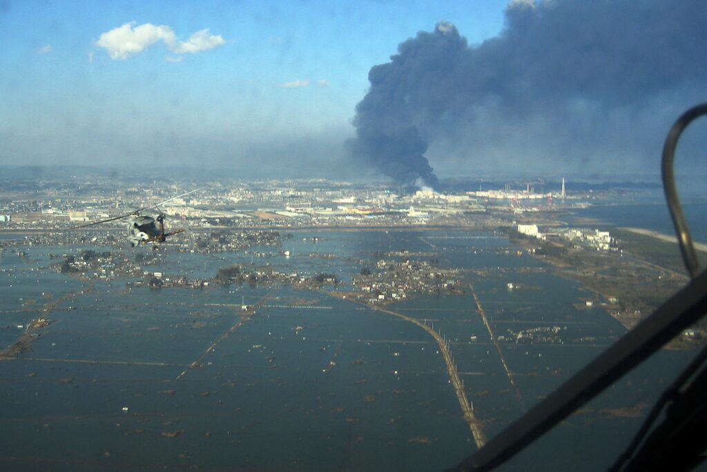 Sendai after the tsunami
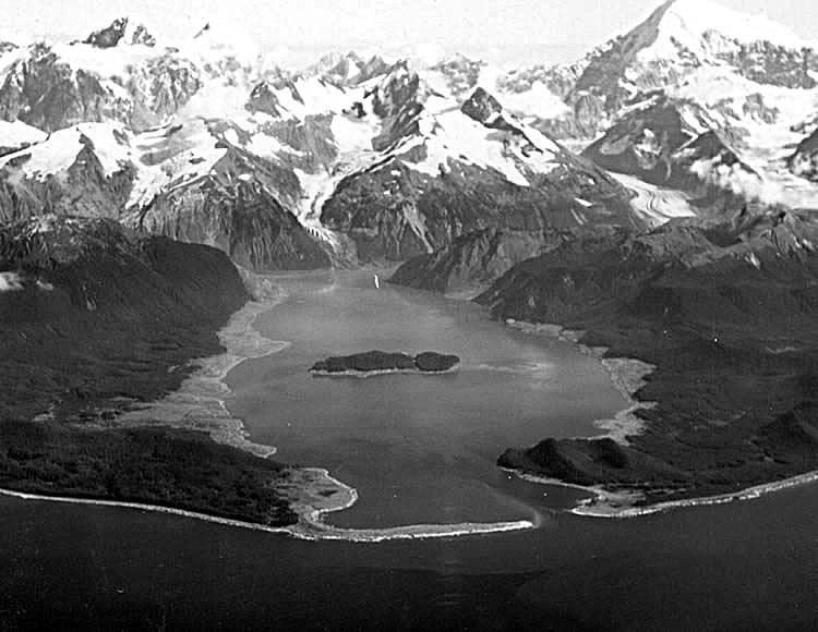 Lituya bay after the tsunami