😂😂😂😂 pic.twitter.com/fvjqEIPkne
— 🅶🅾🆁🅺 (@Raclure03) November 4, 2025
Saturday, November 8, 2025
Friday, November 7, 2025
Northern depths of the Great Barrier reef

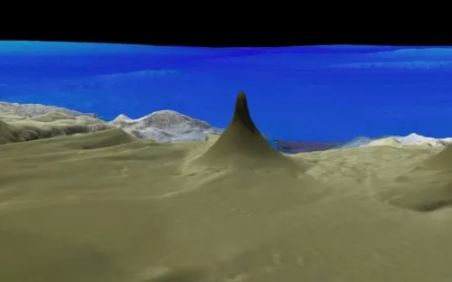
At the bottom, the tower is nearly a mile (1.6 kilometers) wide.
But from there, it becomes much more narrow, rising 1,640 feet (500 meters), and stopping just 130 feet (40 meters) below the surface of the ocean.
Above, a 3D image of the tower.
(Source: Schmidt Ocean Institute.)
(Source: Schmidt Ocean Institute.)
From SchmidtOcean
The Cape York Peninsula lies in the far northern Great Barrier Reef (GBR) Marine Park.
The peninsula is one of the most isolated regions of the Australian continent and little is known about what lies in the offshore deeper waters.
Scientists consider these deeper waters to be a frontier area of the GBR.
The peninsula is one of the most isolated regions of the Australian continent and little is known about what lies in the offshore deeper waters.
Scientists consider these deeper waters to be a frontier area of the GBR.

Cape York in the GeoGarage platform (AHS nautical raster chart)
Sparse information from previous mapping expeditions indicates complex deep sea canyons, massive landslides, and detached mesophotic (deep) reefs rising from around 500 meters below the sea surface.
However, why these detached reefs exist and the structure of the deep sea canyons are unknown and unexplored.
Following two successful cruises – Visioning Coral Seas and Seamounts, Canyons, and Coral Reefs – Dr. Robin Beaman of James Cook University and his Co-PI Mardi McNeil will voyage aboard R/V Falkor for a third time.
Their team will utilize mapping and ROV surveys to understand what lies in the northern depths of the Great Barrier Reef.
Astonishing Geologic Features

Falkor ship
Continuing on from previous expeditions earlier this year, the science party and the Falkor crew will expand their work taking inventory of the GBR’s submarine canyons and any other unusual geological features.
During the transit northwards, the expedition will begin by mapping the Swain slide, a 20 kilometer long underwater landslide discovered off the Swain Reefs.
Why this massive landslide exists perplexes scientists, as there are no immediate geologic features to explain how it happened.
Bathymetric mapping data and ROV surveys will help describe and determine the age of the Swain slide.
The team aboard R/V Falkor will then map the largely unexplored northern continental slope offshore of Cape York Peninsula.
There is limited information about the seafloor in this region and detailed mapping has not yet occurred.
Existing maps indicate the canyons of the northern extent have very different structures and characteristics from the Ribbon Reef canyons explored on the previous expedition.
During this Cape York exploration, scientists will utilize R/V Falkor’s advanced multibeam mapping systems to examine the seafloor topography.
The goal is to ascertain the formative processes which make these canyons different from other parts of the GBR.
The new multibeam data will greatly advance the characterization of Australia’s massive and ecologically important marine estate.
All data will be added to the Australian government databases and made publicly available.
Explore the tools and capabilities of ROV SuBastian in this animated video.
Life Along the Reef Slope
ROV SuBastian will work in tandem with the multibeam systems, in order to determine if structurally-different bottom features facilitate the presence of deep-sea coral habitats unique to the region.
The ROV data will also allow scientists to examine if the mesophotic (twilight zone) corals have been affected by recent coral bleaching.
As demonstrated by the work done in Bremer Bay, Perth Canyon, and most recently in the Ningaloo Canyons, ROV SuBastian can make a major impact in the discovery of new species, habitats, and in understanding key processes in these little-known ecosystems.
In a country where there are few opportunities to explore the deep sea with a dedicated science ROV, this expedition will have a major impact in visioning the Coral Sea.
Drowned and Detached Reefs
The submerged (also known as drowned reefs) shelf edge reefs of the GBR are considered the world’s longest fossil reef.
How far north the drowned reefs extend into the Cape York region is unknown and one objective for the mission is to determine the northern extent of the drowned reefs along the shelf edge.
The science team will also examine numerous detached deep reefs – isolated reefs which have grown upon a platform of continental rock that extends out of the slope deeper than the shallower GBR shelf reefs.
These reefs may be tens of thousands of years old, rising up from the deeper platform but have completely unmapped bases.
The goal is to map and survey the foundation of the reef bases and surrounding platform to gain insight into the detached reef’s formation and ecosystems.
Thursday, November 6, 2025
GPS jamming is now a mainstream maritime threat
Shipping is on high alert.
— Windward (@WindwardAI) June 23, 2025
🚨 After U.S. strikes on Iran, the Strait of Hormuz saw a 28% drop in inbound traffic.
📡 1,600+ vessels hit by GPS jamming — from VLCCs to LNG carriers.
⚠️ Risk level now highest in 20+ years.
What comes next? Full report here: https://t.co/ZZxdEcf1aS… pic.twitter.com/lUuykmav6R
At a GlanceGPS jamming accelerated across the global fleet in 2025, evolving from a contained threat to a widespread operational disruptor affecting trade, enforcement, and compliance.
In Q1, new spoofing hubs emerged and AIS jumps exceeded 6,000 km, pointing to more coordinated and deliberate interference.
By Q2, GPS jamming surged, impacting over 13,000 vessels, with geopolitical flashpoints like the Iran conflict driving mass spoofing events and false port calls.
In Q3, spoofing became routine across 27 EEZs, with growing overlap between GPS jamming and other deceptive shipping practices like flag hopping and identity laundering.
Looking to 2026, the focus must shift from detection to resilience, with systems that can decode deceptive data and drive action when visibility is compromised.
What Three Quarters of GPS Jamming Reveal About Maritime Risk
In 2025, GPS jamming became maritime’s fastest-growing and most disruptive operational challenges.
What began as concentrated interference in a few high risk zones quickly escalated into a global-scale disruption with thousands of vessels broadcasting false locations and incidents reported in every major trade region.
As the year progressed, the signals grew bolder, the targets more strategic, and the operational fallout more widespread.
Due diligence was compromised.
Enforcement delayed.
Operations were disrupted, often in real time.
And there’s no sign of slowing down.
This blog unpacks the evolution of GPS jamming across Q1, Q2, and Q3 2025, and what the patterns say about the maritime risk environment heading into 2026.
Q1: From Interference to Pattern
At the start of 2025, GPS jamming wasn’t new, but the nature and behavior of the signals shifted in ways that pointed to a broader, more coordinated threat.
AIS jumps that previously averaged 600 kilometers suddenly exceeded 6,300 kilometers, introducing new levels of risk for both real-time decision-making and post-event investigations.
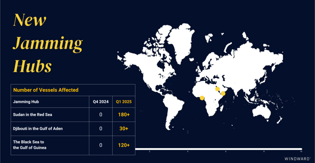
At the same time, three new jamming hubs emerged – in Sudan, Djibouti, and the Black Sea–Gulf of Guinea corridor – marking a geographic expansion beyond previously monitored zones.
At the same time, three new jamming hubs emerged – in Sudan, Djibouti, and the Black Sea–Gulf of Guinea corridor – marking a geographic expansion beyond previously monitored zones.
Equally notable was the shift in spoofing behavior.
Instead of the dense, circular signal loops that characterized earlier incidents (in Q4 2024), Windward observed larger, defined spoofing zones and straight-line anomalies, designed to confuse tracking systems and obscure vessel behavior.
Instead of the dense, circular signal loops that characterized earlier incidents (in Q4 2024), Windward observed larger, defined spoofing zones and straight-line anomalies, designed to confuse tracking systems and obscure vessel behavior.
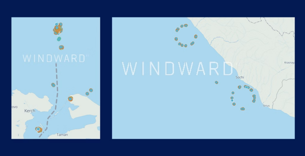
Left side: Black Sea jamming patterns in Q4 2024 | Right side: Black Sea jamming patterns in Q1 2205.
The ripple effects were immediate.
GPS spoofing disrupted port entrances, rerouted cargo, and reduced situational awareness, directly impacting trade operations and undermining maritime safety protocols.
The ripple effects were immediate.
GPS spoofing disrupted port entrances, rerouted cargo, and reduced situational awareness, directly impacting trade operations and undermining maritime safety protocols.
Q2: GPS Jamming Goes Global
In Q2, GPS jamming escalated dramatically, both in volume and in visibility.
While spoofing events in Q1 were mostly isolated, the second quarter saw a sharp shift in scale.
Clusters of spoofed vessels began appearing simultaneously across multiple regions, with longer spoofing durations and wider jumps indicating a more synchronized, deliberate pattern.
More than 13,000 vessels were impacted globally during the quarter, with new hotspots emerging in the Arabian Gulf, Mediterranean, and Baltic regions.
But the biggest disruption came from the Iran conflict, which triggered a jamming supercluster in the Eastern Mediterranean.
Between June 13 and June 24, more than 12,000 spoofing incidents were recorded, impacting over 3,000 vessels worldwide.
Of the vessels affected, 97% “jumped” onto land, generating false port calls in Iran and triggering screening alerts across multiple systems.
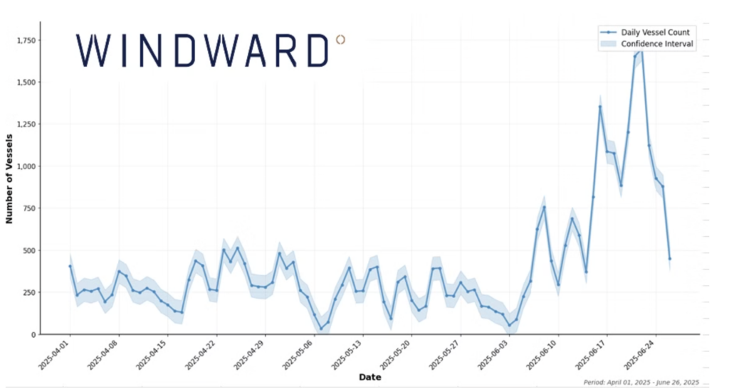 GSP jamming in the Arabian Gulf during Q2 2025.
This wasn’t just a technical anomaly.
Due diligence workflows failed, enforcement actions were delayed, and routine screening tools flooded users with false positives, obscuring actual high risk behavior.
By the end of Q2, GPS jamming had evolved into a global challenge to maritime transparency, undermining visibility, trust, and enforcement and infrastructure scale.
Q3: A Normalized Threat with Complex Layers
By Q3, GPS jamming had become a daily operational reality, not an outlier event.
Windward detected spoofing activity in 27 different Exclusive Economic Zones (EEZs), with signals recorded across every major trade region.
More than 11,600 vessels were affected globally, with a new hotspot emerging near Nakhodka Bay and the Kozmino oil terminal – a key Russian energy export hub in the Far East.
While slightly fewer vessels were impacted than in Q2, the scale still marked a 510% increase over Q1, confirming a long-term trajectory rather than a temporary spike.
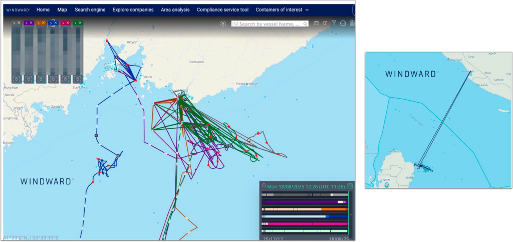 Jamming patterns in the Nakhodka Bay (left) during Q3 2025 and recent electronic interference off Qatar.
Spoofing now routinely targets sensitive port zones, chokepoints, and enforcement-heavy jurisdictions, complicating due diligence and increasing the risk of misidentifying high risk behavior.
More critically, Q3 revealed deepening overlaps between spoofing and other deceptive shipping practices (DSPs).
Vessels engaged in identity laundering, flag hopping, and false port calls frequently exhibited spoofed positions, creating layered anomalies that blurred the line between error and intent.
Illicit activity was increasingly masked by background noise, leaving compliance, intelligence, and security teams struggling to isolate real threats in a sea of false signals.
Three Quarters In: What the Patterns Say
When viewed across Q1–Q3, the trajectory of GPS jamming has become undeniable and deeply operational:Scale: From a few hundred spoofed jumps in Q1 to over 13,000 vessels impacted in Q2 and Q3.
Spread: From three jamming hubs to more than 10 global hotspots across four continents.
Proximity: From regional interference to routine disruption near oil terminals, trade corridors, and enforcement zones.
Side Effects: False port calls, screening fatigue, and real violations hidden by noise.
Each quarter in 2025 brought a measurable shift.
In Q1, spoofing behavior became more strategic, targeting chokepoints and shifting signal patterns.
Q2 marked a turning point, with widespread geographic expansion and mass spoofing events tied to geopolitical flashpoints.
By Q3, jamming had normalized across the global fleet and often overlapped with other deceptive behaviors, making operational transparency harder to achieve.
This trendline suggests 2026 won’t bring stabilization – it will demand adaptation.
Organizations that rely on static screening, siloed enforcement, or manual workflows will fall behind.
The next phase of risk management will require platforms that connect the dots automatically – across quarters, behaviors, and signals – to enable faster decisions when the data is designed to deceive.
The Way Forward: Building GPS Jamming Resilience
Windward’s analysis across Q1-Q3 shows that GPS jamming isn’t going away, but its impact can be managed.
Mitigation starts with real-time anomaly detection.
But resilience requires a more strategic approach:Behavior-based risk modeling that analyzes vessel behavior over time to assess intent – even when location data is spoofed.
AI-powered voyage and port call validation to automatically flag implausible stops and spoofed positions before they disrupt workflows.
Explained, actionable risk signals that help operations, compliance, and intelligence teams act with confidence – even when the raw data is compromised.
Links :
- Windward : Ceasefire Effect: GPS Jamming Eases and Unusual AIS Messages Reflect Maritime Caution / Shipping on Highest Alert After U.S. Strikes Iran. What Comes Next?
- GeoGarage blog : GPS jamming on the rise as Israel-Iran conflict enters fourth ... / IMO asks nations to stop jamming GPS, citing risk to shipping
Wednesday, November 5, 2025
Shadow fleets, sanctions, and the billion-dollar opportunity in maritime intelligence
From Substack by Fererica Maiorano
When the Financial Times dropped its investigation into Mittal Energy’s purchase of Russian crude transported on sanctions-listed vessels, it was framed as another sanctions-evasion story — a billionaire’s refinery caught in the fog of global oil trading.
But if you’re an investor, operator, or founder in the intersection of shipping, energy, and data tech, this episode should read very differently. It’s not just about Russia or sanctions.
It’s a live demonstration of a global infrastructure failure — and the next big data frontier: maritime transparency.
The FT’s reporting found that HPCL-Mittal Energy Limited (HMEL), co-owned by Lakshmi Mittal and Hindustan Petroleum, received roughly $280 million in crude oil shipments this year from Russia’s Arctic port of Murmansk.

That in itself isn’t unusual.
Since 2022, India has become one of the largest buyers of discounted Russian crude.
The problem lies in how the oil got there.
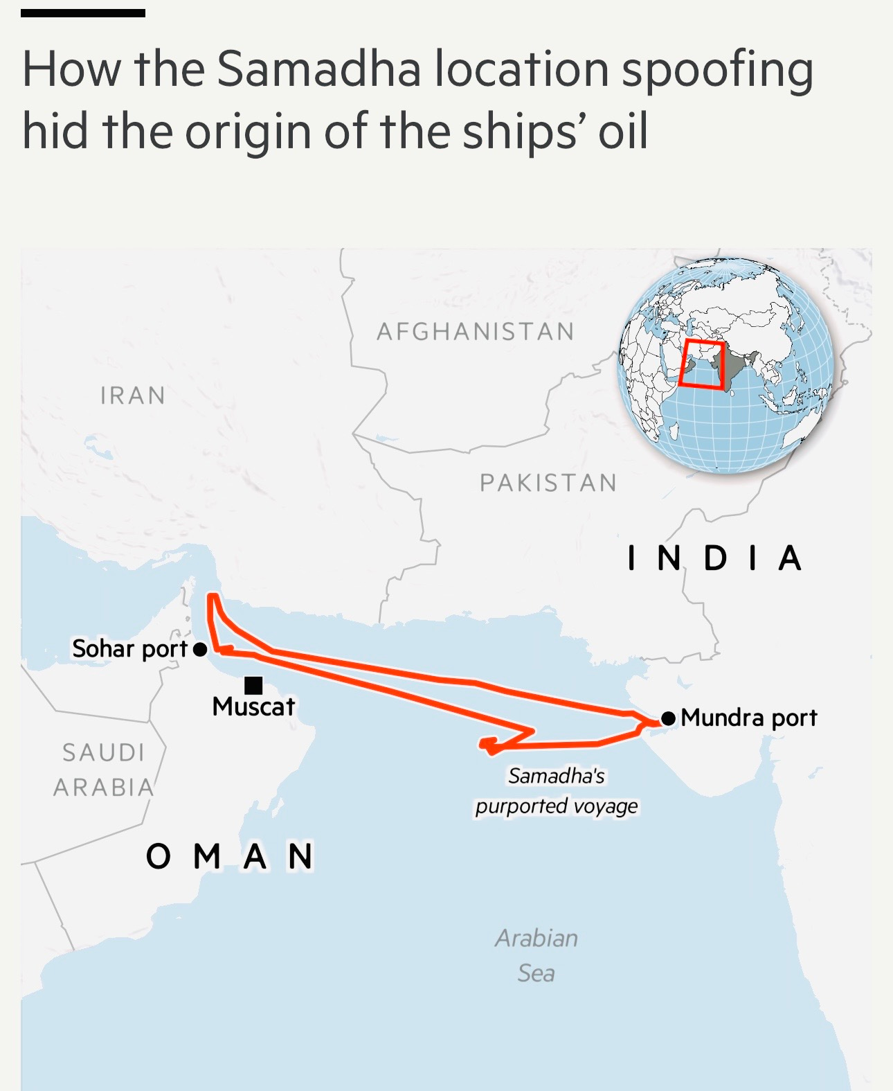
The shipments were transported on US-sanctioned vessels — Belgorod, Dignity, Primorye, and Danshui — that spoofed their AIS transponders, broadcast false locations, and conducted ship-to-ship (STS) transfers in the Gulf of Oman.
A fifth vessel, the Samadha — not initially sanctioned but later blacklisted by the UK — completed the “clean” leg of the trip to India.
This choreography of deception is straight out of the playbook long used by Iranian and Venezuelan operators:
The FT’s reporting found that HPCL-Mittal Energy Limited (HMEL), co-owned by Lakshmi Mittal and Hindustan Petroleum, received roughly $280 million in crude oil shipments this year from Russia’s Arctic port of Murmansk.
That in itself isn’t unusual.
Since 2022, India has become one of the largest buyers of discounted Russian crude.
The problem lies in how the oil got there.
The shipments were transported on US-sanctioned vessels — Belgorod, Dignity, Primorye, and Danshui — that spoofed their AIS transponders, broadcast false locations, and conducted ship-to-ship (STS) transfers in the Gulf of Oman.
A fifth vessel, the Samadha — not initially sanctioned but later blacklisted by the UK — completed the “clean” leg of the trip to India.
This choreography of deception is straight out of the playbook long used by Iranian and Venezuelan operators:
- sanctioned ship goes dark,
- crude is offloaded mid-sea to a non-sanctioned intermediary,
- paperwork is scrubbed,
- cargo arrives looking “legitimate.”
The reality?
The existing compliance stack is blind to real-world spoofing behavior.
The Shadow Fleet Economy
The “dark fleet” — vessels engaged in deceptive shipping practices — now numbers somewhere between 600 and 800 ships, according to Lloyd’s List and Windward.
These tankers operate in a twilight world of flag-hopping, opaque ownership, and synthetic identity data.
The Shadow Fleet Economy
The “dark fleet” — vessels engaged in deceptive shipping practices — now numbers somewhere between 600 and 800 ships, according to Lloyd’s List and Windward.
These tankers operate in a twilight world of flag-hopping, opaque ownership, and synthetic identity data.
Many are registered in Seychelles, Panama, or the Marshall Islands, insured by non-Western providers, and tracked through false AIS signals.
In short: the world’s most critical trade system has a data problem.
For context, 90% of global goods move by sea.
In short: the world’s most critical trade system has a data problem.
For context, 90% of global goods move by sea.
Yet the infrastructure tracking those movements — AIS, registry databases, port logs — was never built to handle intentional deception.
It was designed for collision avoidance, not sanctions enforcement.
The Venture opportunity:
The Venture opportunity:
Building the Maritime Data Stack
If you’re a VC looking for the next big thing, this is it.
The shipping world is quietly going through the same digital transformation the financial markets went through after 2008 — when compliance, fraud analytics, and counterparty risk moved from “legal back-office” to data-native, AI-driven systems.
Here’s what’s being built right now — and where the opportunities lie:
1. Behavioral Vessel Intelligence
Companies like Windward, Spire Global, HawkEye 360, and Maritime AI are using satellite radar (SAR), optical imaging, and RF geolocation to detect ships that are lying about their position. Startups in this space are training models that can flag vessels whose movement patterns are statistically inconsistent with their declared routes — in real time.
2. Sanctions Graph Intelligence
Tools like Altana AI and Palantir’s Foundry are building knowledge graphs that map relationships between shipowners, charterers, and suppliers.
The future of sanctions compliance is entity linkage, not just list-checking.
A vessel spoofing its transponder is one thing; a corporate entity hiding behind a web of offshore shells is another.
A vessel spoofing its transponder is one thing; a corporate entity hiding behind a web of offshore shells is another.
The intersection of these two data problems is where the next successful ventures will emerge.
3. Trade Finance & Smart Documentation
Right now, bills of lading and shipping manifests are still shockingly manual. Integrating blockchain provenance systems — think CargoX, TradeLens, Dockflow — into trade finance could allow auditors and regulators to verify every link in the logistics chain.
Once regulators (or insurers) start demanding this kind of traceability, the adoption curve will be fast and steep.
4. Geopolitical Risk APIs
Imagine an API that scores every maritime route and cargo chain in terms of sanctions exposure, ESG risk, and data confidence.
That’s what firms like Everstream Analytics and Veridapt are inching toward — and what the next generation of maritime fintechs should be building.
Why VCs should care
Global shipping is a $14 trillion industry — and it’s almost completely under-digitized.
Regulatory pressure is rising, data availability is exploding, and yet, most legacy systems still treat compliance as static record-keeping.
The combination of:
Just as fintechs like Stripe and Plaid turned compliance rails into platforms, maritime AI will turn sanctions intelligence into infrastructure — the invisible layer enabling trade finance, logistics, and ESG reporting.
The Strategic Endgame
This isn’t only about avoiding penalties.
Why VCs should care
Global shipping is a $14 trillion industry — and it’s almost completely under-digitized.
Regulatory pressure is rising, data availability is exploding, and yet, most legacy systems still treat compliance as static record-keeping.
The combination of:
- cheap satellite imagery,
- better ML models, and
- rising sanctions enforcement
Just as fintechs like Stripe and Plaid turned compliance rails into platforms, maritime AI will turn sanctions intelligence into infrastructure — the invisible layer enabling trade finance, logistics, and ESG reporting.
The Strategic Endgame
This isn’t only about avoiding penalties.
In a fragmented, multipolar world, data transparency becomes geopolitical leverage.
Countries like India, China, and Turkey — now key buyers of Russian crude — will increasingly rely on localized compliance ecosystems. The next race is between Western transparency standards and non-aligned trade protocols built around alternative data flows.
For investors, this is the moment to back companies that can sit on top of both — infrastructure players that don’t just monitor sanctions, but build trust networks across opaque markets.
Because if the FT’s Mittal story proves anything, it’s this:
The next supply chain superpower won’t be the company that moves the most oil.
It’ll be the one that knows — with data certainty — where every barrel came from.
This industry has always been foggy, the difference now is that we have the tools to make it transparent — and whoever builds them will define the next decade of trade.
Links :
- Newsweek : Satellites Capture Iran’s Suspected ‘Shadow Fleet’ in Action
- The Telegraph : Putin’s shadow fleet under threat as Trump tries to ‘terrify’ Russia’s allies
- NPR : How Russia’s shadow fleet is sailing around oil sanctions / How Russia's shadow fleet of oil tankers evades western sanctions
- The Economist : The flashing red threat from Russia's dark fleet
- ENR : Up to 1,400 ships: Russia’s shadow fleet worries the EU
- GeoGarage blog : Shadow tanker fleet: A ticking time bomb waiting to cause ...
Tuesday, November 4, 2025
November full moon 2025: The Beaver supermoon will be the biggest and brightest of the year
 (Image credit: Soumyabrata Roy/NurPhoto via Getty Images)
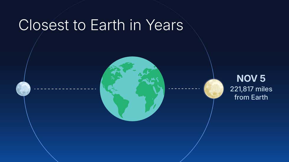
November's full Beaver Moon will occur on Nov.5 and will be the biggest and brightest moon of 2025.
The full moon of November, called the Beaver Moon, will be full illuminated on Nov.5 at 8:19 a.m.
Eastern Time (1319 GMT), according to the U.S.Naval Observatory.
This moon will also be a "supermoon," meaning the full moon coincides with our satellite's closest point to Earth in its elliptical orbit.
It will be the biggest and brightest full moon of 2025.
Two days later, the just-past full moon will occult Beta Tauri, otherwise known as Elnath.
The occultation will be visible from South America and Africa and take place on the night of Nov. 7-8.
The moon is called full when it is exactly opposite the sun in the sky (from the perspective of the Earth).
The position is measured where the moon is relative to Earth itself rather than any given location, so the time depends on one's longitude.
This full moon occurs in the morning hours on the east coast of the Americas, and in the afternoon in Europe; to catch the moon at the moment it reaches full phase, one has to be in Asia or the western coast of North America (in which case one will catch it just before the moon sets and the sun rises).
For example, in Los Angeles, the full moon is at 5:19 a.m. Nov. 5, and moonset is at 6:31 a.m.
Sunrise happens before the moon sets, at 6:17 a.m., so the two will share the sky, albeit briefly.
Further west, in Honolulu, the full moon is at 3:19 a.m., well before sunrise at 6:37 a.m.local time.
The full moon happens in the evening hours in cities such as New Delhi, where full phase is at 6:19 p.m. and moonrise is at 5:11 p.m. local time. (sunset is at 5:33 p.m.), and in Tokyo, where the full moon occurs at 10:19 p.m.
As one goes further east the full moon occurs after midnight; in Sydney, Australia, the full moon is at 12:19 a.m. Nov. 6.
In New York City, the moon rises at 4:35 p.m.Eastern; sunset is at 4:47 p.m.
As in Los Angeles, one will be able to see the setting sun and the moon in the sky simultaneously, though only for a few minutes.
A full moon's maximal altitude in the sky reflects the sun's in six months — so, for example, from New York, where November is in late fall, the moon will reach its highest point in the sky at 12:12 a.m.
on Nov. 6, 72 degrees above the southern horizon.
This is similar to where the sun would be in early May at local noon.
In the Southern Hemisphere, where November is late spring, the moon is only about 32 degrees above the northern horizon at 1:38 a.m. Nov. 6.
This is one reason that for Northern Hemisphere observers, wintertime moons often appear brighter; it's because they are generally higher in the sky.
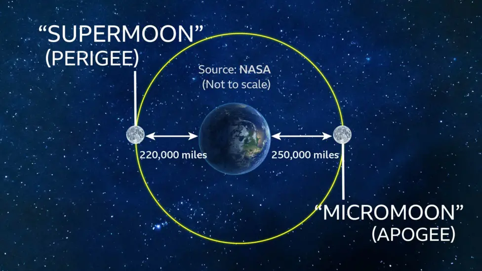
At its 'perigee' the Moon is 30,000 miles closer to Earth than at its 'apogee'
The spectacle will be best viewed around dusk from November 4-6, unless Mother Nature has other plans.
This full moon is a "supermoon" because it happens when the moon is at a point in its orbit where it is closer to Earth.
The moon's orbit is nearly circular, but not exactly so.
The moon's average distance is 238,854 miles (384,399 kilometers), but since its orbit is an ellipse, it can be as close as 221,460 miles (356,400 km).
In this case, the moon will be about 221,700 miles (356,800 km) away, and will appear slightly brighter and larger than a "normal" full moon.
However, the difference is relatively small, on the order of 11 percent, so it's unlikely to be noticed by any but the most careful observers.
MOON OCCULTS BETA TAURI
On Nov. 8, the just-past-full moon will occult the star Beta Tauri, also known as Elnath.
Beta Tauri is visible all night in mid-northern latitudes and is known for being shared between Taurus and Auriga.
To see the occultation, one needs to be in South America or western and central Africa.
Formosa, Argentina, is near the western end of the zone where observers can see both the disappearance of Beta Tauri behind the moon and its reappearance.
Beta Tauri will appear to touch the right (eastern) side of the rising moon at 11:03 p.m. local time on Nov. 7; the moon will be low in the northeastern sky.
The star will reappear at 11:34 p.m. from behind the left side of the moon.
In Bolivia, from Santa Cruz, the occultation will start at 9:43 p.m. local time and end at 10:43 p.m., with the moon, as in Argentina, low in the sky, about 7 degrees above the northeastern horizon.
From Santa Cruz, Elnath will look as though it disappears behind the lower right half of the moon and reappears on the upper left.
The occultation will be visible in most of Brazil, though not in either Rio de Janeiro or São Paolo.
In Brasilia, the moon will be higher in the sky, about 23 degrees, and Elnath will disappear at 11:01 p.m.
local time, and reappear at 11:54 p.m.
In Africa, the occultation is in the predawn sky; in Dakar, Senegal, the occultation starts at 3:06 a.m.
local time and the moon will be almost straight up, a full 75 degrees above the northern horizon.
Elnath will disappear behind the eastern side of the moon and reappear on the western side at 4:29 a.m.
VISIBLE PLANETS
On the night of the November full moon, Saturn will be the first planet visible for mid-latitude Northern Hemisphere sky watchers.
By 6 p.m., the sun has been down for more than an hour and the sky is dark; Saturn will be 32 degrees high in the southeast, a bright yellow-white "star" that will be easy to spot — especially in urban, light-polluted regions — because the stars around it in the constellations Aquarius and Pisces are relatively faint.
Saturn sets at 2:29 a.m. Eastern Time on Nov. 6 in New York City; the local time will be similar in other locations at similar latitudes, such as Denver, San Francisco, or Chicago.
Jupiter follows Saturn, rising at 9:20 p.m. in New York City on the evening of Nov. 5.
The planet reaches its maximum altitude at 4:41 a.m. on Nov. 6, reaching about 70 degrees.
Jupiter is accompanied by the stars Castor and Pollux; as it rises, Pollux will be above and to the left of Jupiter and Castor further upwards and to the left; the three objects make a rough line pointing to the horizon.
Just before dawn, Venus rises at 5:15 a.m., but from New York, it will be very close to the horizon by sunrise at 6:32 a.m.; at that point, it will only be 12 degrees high, so to catch it, one will need to have an unobstructed horizon and clear weather.
For Southern Hemisphere observers, Saturn is much higher.
In Sydney, Australia, sunset is at 7:26 p.m. local time; by the time the sky gets dark at about 8 p.m., Saturn is 52 degrees above the northeastern horizon.
Saturn sets at 3:56 a.m. in Sydney on Nov. 6.
As in the Northern Hemisphere, Jupiter rises after Saturn, at 12:41 a.m. in Sydney on Nov. 6.
As the sky appears "upside down" for Southern Hemisphere observers, the stars Castor and Pollux will be below Jupiter; Pollux will be below and to the left and Castor slightly below and to the left of Pollux (as one faces northeast).
When Jupiter crosses the meridian in Sydney, it will be lower in the sky than in the Northern Hemisphere; at 5:42 a.m., it will reach 35 degrees above the northern horizon.
At that point, the sky will be getting light; the sun rises in Sydney at 5:50 a.m.
Venus rises at 5:13 a.m., and in mid-southern latitudes is so close to the sun as to be effectively invisible; by 5:30 a.m., it is still only about three to four degrees above the horizon and the sky will be getting light enough that it is very difficult to see.
Mars and Mercury will both be lost in the glare of the sun; they will reappear later in November.
CONSTELLATIONS
In early November, the Northern Hemisphere winter constellations are starting to rise in the evening.
From mid-latitudes, looking at the full moon at about 9 p.m., one should be able to spot Capella, the brightest star in Auriga the Charioteer, by turning one's attention to the right towards the northeast; Capella will be just below the level of the moon.
Below the full moon is Aldebaran, the brightest star in Taurus, the Bull.
The moon, Capella and Aldebaran will form a right triangle with Aldebaran at the 90-degree corner.
Looking almost straight up at about 9 p.m., one sees the Great Square, an asterism formed by Pegasus, the legendary Winged Horse, and Andromeda.
Andromeda's head, the star Merkab, is the upper left corner of the square, while the other three are Pegasus' wing.
Alpha Pegasi, or Merkab, is the lower right corner, while Beta Pegasi, or Scheat, is the upper right.
The upper left corner is Algenib, or gamma Pegasi.
By about 10 p.m., one can see Orion above the horizon, with the three stars of the Hunter's belt making a near-vertical line in the east-southeast about 15 degrees above the horizon.
The Belt stars are named Alnitak, Alnilam and Mintaka, with Alnitak closest to the horizon.
Around the Belt, forming a rectangular shape, are the four stars that mark the Hunter's shoulders and feet.
To the left of the Belt is the distinctly orange-red star Betelgeuse, and above and to the right of it is Bellatrix.
On the other side of the Belt is Rigel (marking the opposite corner of the box from Betelgeuse) and the last is Saiph, marking Orion's right foot (left from the perspective of an earthbound observer).
Sirius, the brightest star in the sky, rises at 10:36 p.m.
on Nov.
5 in New York City, but it doesn't get well above the horizon until about 1 a.m.
on Nov.
6, when it is 21 degrees high in the southeast.
To the left of Sirius is another bright star, Procyon, which will be to the right and below Jupiter, and recognizable because of its blue-white hue compared to the planet's yellowish cast.
Sirius and Procyon are in the constellations Canis Major and Canis Minor, respectively.
Both stars are among the sun's nearest stellar neighbors; Sirius is only 8.6 light-years away and Procyon is 11.5 light-years distant.
In mid-southern latitudes, in Santiago, Chile or Sydney, Australia, the sky gets fully dark by about 9 p.m.
At that point, one can see the full moon in the northeast.
Turning to the right (southwards) and staying close to the horizon, one can see Canopus, the brightest star in Carina, the Ship's Keel, about 15 degrees high.
Looking straight up from Canopus, almost two-thirds of the way to the zenith, one encounters Achernar, the star marking the end of Eridanus, the River.
Most of the surrounding stars are relatively faint, but in a location with fewer lights, one can see the Phoenix, with its brightest star, Alpha Phoenicis or Ankaa, at an altitude of 75 degrees and almost straight upwards from Achernar.
If one looks due north, one will see the Great Square that marks Pegasus and Andromeda; Saturn will be bright enough that it is a good marker, and if one goes from Saturn straight towards the horizon, the line cuts the Great Square in half.
Alpha Andromedae, or Alpheratz, will be the star in the lower right corner, while Scheat is the lower left.
BEAVER MOON AND OTHER NOVEMBER MOON NAMES
While Americans — specifically those in the U.S.
and Canada – might call the November full moon the Beaver Moon, such "traditional" names come from the European settler cultures and the Native peoples they came into contact with; most are relatively recent.
Among Native people, especially, full moons have had various names for millennia.
The Cree, for example, called it Kaskatinowipisim or "Freeze up Moon." The Cree nation's historic territories are in the Great Lakes region; October and November are when nighttime freezing temperatures become more regular.
But further south, the Cherokee adopted the name "Trading Moon" for November, as it was just after many harvests and markets would be active, while southwestern peoples often named the November lunation after harvests.
The KhoiKhoi people in South Africa called the November full moon the Milk Moon, according to the Center for Astronomical Heritage, an organization that works to preserve local astronomical traditions.
In India, the November full moon marks the festival celebrating the birth Guru Nanak, the founder of Sikhism.
This is a public holiday in much of India.
If you hope to snap a photo of the full moon, our guide on how to photograph the moon can help you make the most of the event.
If you need imaging equipment, our best cameras for astrophotography and best lenses for astrophotography have recommendations to make sure you're ready for the next skywatching target.
Links :
- BBC : Bonfire Night's Beaver supermoon to be biggest and brightest of 2025
- Science : Does The Full Moon Really Affect Our Sleep? Here's The Science
- LiveScience : Beaver Supermoon: The biggest, brightest full moon of the year is about to rise
- Mashable : November full moon 2025: See the Beaver supermoon
Monday, November 3, 2025
Kind man once saved a penguin and now it swims 5,000 Miles every year just to visit him again
A Magellanic penguin that migrates from Patagonia and a retired bricklayer in a Brazilian fishing village have struck up an unusual friendship.
The Wall Street Journal (@wsj)
dug deeper into the story and captured De Souza and Dindim live in
action in a YouTube video.
He was seen casually sitting on the beachside
while the penguin strolled around his feet, often looking up to him to
interact.
The adorable relationship between them shone through
confirming the iconic rescue story.
Local fishermen chimed in saying
that Dindim occasionally stays on the island for a week, like a visiting
relative, and then suddenly walks down to the beach and leaves.
Photo: Paul Kiernan/The Wall Street Journal
From GreenMatters
The Magellanic penguin was overtly selective with people and only allowed the man who rescued its life to touch and feed him.

An adorable penguin arrives at the beach after crossing the ocean.
(Representative Cover Image Source: Pexels | Taryn Elliott) | (R) Dindim, the penguin, meets his favorite human in Brazil.
Penguins are not considered to have the same level of emotional complexity as humans.
But a rare occurrence between a 71-year-old man and a South American Magellanic penguin may encourage experts to reconsider.
In 2011, pensioner Joao Pereira de Souza was blessed with an opportunity to rescue a dying penguin left stranded on a beach near his home in Rio de Janeiro, Brazil.
The poor bird was engulfed in a lather of oil and starving.
The chances of survival were low but de Souza did what he could to rescue the penguin, per the Independent.
A unique connection since formed has kept the penguin returning to the man every year.

A penguin swimming underwater.
(Representative Image Source: Pexels | Lea Lervis)
(Representative Image Source: Pexels | Lea Lervis)
The old man was committed to restoring the penguin to his good health and took him home.
He dedicated his time and efforts to removing the sticky oil from the bird’s feather, which took about a week, by giving him showers and also feeding him sardines.
De Souza named him Dindim.
Soon after the penguin grew new feathers and was strong enough, the man took him to the beach to help him return to his habitat.
“But he wouldn’t leave, he stayed with me for 11 months, and then just after he changed his coat with new feathers, he disappeared,” de Souza said in an interview with Globo TV, the source revealed.
There was this 71-year-old retired man called Joao Pereira de Souza who lived in Brazil
One day he found a South American Magellanic penguin totally covered in oil and very unwell.
He nursed it back to health but the penguin didn’t want to leave, when he did eventually leave,… pic.twitter.com/CDDmXvAQOY— Science girl (@gunsnrosesgirl3) September 10, 202
The locals told him that Dindim was gone for good and would not return.
Quite miraculously, he has been returning to the island off the coast of Rio to visit the man for the past four years.
“He arrives in June and leaves to go home in February and every year he becomes more affectionate as he appears even happier to see me” the man added.
The Magellanic penguin travels about 5000 miles annually to pay a visit to his lifesaver at the exact island where they first met.
The bird typically breeds on the Patagonia coasts of Argentina and Chile but does not mind a long swim to Brazil and spends up to eight months living with the retired fisherman in his house.

Two penguins standing next to each other on green grass.
(Representative Image Source: Pexels | William Warby)
De Souza further noted, “I love the penguin like it’s my own child and I believe the penguin loves me.” Hinting at their special bond, he said that no other person is allowed to touch the penguin or pet him.
However, Dindim is free to lay on the rescuer’s lap, have showers, and also allows him to “feed him sardines and to pick him up.” Biologist Paulo Krajewski interviewed De Souza and was awestruck by the special bond between him and the bird.
“I have never seen anything like this before.
I think the penguin believes Joao is part of his family and probably a penguin as well,” the research told the outlet.
To express his happiness, Dindim reportedly wags his tail and honks in delight.
Links :
Sunday, November 2, 2025
The Hyundai 10000 : one of the world’s largest floating sheerleg cranes
The Hyundai 10000
— ViralRush ⚡ (@tweetciiiim) October 5, 2025
One of the world’s largest floating sheerleg cranes pic.twitter.com/b7n3FC627K
Subscribe to:
Posts (Atom)