Saturday, September 3, 2022

Earth’s iconic waves, observed by Landsat


Video by Kathryn Hansen. NASA Earth Observatory images by Lauren Dauphin, using Landsat data from the U.S. Geological Survey, topographic data from the Shuttle Radar Topography Mission (SRTM), and bathymetry data from the General Bathymetric Chart of the Oceans (GEBCO).
Photographs “Teahupo’o Surfing” by The TerraMar Project; “Can you see the surfer?” by Luis Ascenso; “Local surfers from above” by neverything; “Jeff Rowley Jaws Peahi Maui Solo Surf Session Thanksgiving” by Jeff Rowley, are all licensed under CC BY 2.0.
Photographs by Thom Milkovic, Gil Ribeiro, Karim Sakhibgareev, Carles Rabada, Bailey Mahon, Jeremy Bishop, Photoholgic, and Tim Marshall are from Unsplash.
Music, “They Think I'm Alone Now (instrumental),” by Beach Creeper.

From NASA

Editor’s note: The following text is a transcript of the video and includes links to detailed descriptions of each satellite image.


With more than 370,000 miles of coastline on Earth, there are plenty of places where epic waves build up, curl over, and hurtle toward the shore—much to the thrill of surfers.

There are some places where these waves are so magnificent that they can be seen from space.
With the broad perspective of satellites, we can see how these iconic waves develop into the world’s tallest, longest, fastest, and heaviest. 
 
localization with the GeoGarage platform (SHOM nautical raster chart)

Off the southern coast of Tahiti, the heavy waves at Teahupo’o are influenced by the island’s remoteness.
The swells from storms thousands of miles away often travel unimpeded across the South Pacific toward the southern coast.
These southwesterly swells carry energy across the deep, open ocean until crashing into the very shallow reef off Teahupo’o.
The waves heave a crushing amount of water toward the shore, rideable by the bravest surfers. 
 
localization with the GeoGarage platform (DHNP nautical raster chart)

In Peru, the famously long waves at Chicama are influenced by the shape of the land.
Waves arriving from the open Pacific roll nearly parallel to this part of Peru’s coastline.
They start to roll up at a cape that juts into the Pacific.
Then they progressively break at a series of four points along the shoreline.
Swells overturn and peel as they roll over the ever-shallower seafloor.
When conditions are just right, surfers can ride Chicama’s waves for minutes at a time. 
 

localization with the GeoGarage platform (NOAA nautical raster chart)
 
Off Maui’s southern shore, ripping-fast waves known as “freight trains” show up in summer, spurred by faraway storms.
The late-season waves in this image were probably influenced by Hurricane Walaka, a category-4 storm brewing nearly 1,000 miles away.
The speed of the waves along this part of Maui comes from the dramatic transition of the seafloor from deep water to shallow.
Still, freight train waves are relatively rare, requiring swell to approach the bay from the perfect southerly direction.
Big-wave surfers can more consistently find extreme waves on the island’s north side, where during the winter months the waves come alive at a surf spot known as “Jaws.” 

localization with the GeoGarage platform (NGA nautical raster chart)

In Portugal, the waves at Nazaré sometimes build up due to far away storms.
In October 2020, towering waves piled up due to the remnants of Hurricane Epsilon and a low-pressure system near Greenland.
That’s when a Portuguese surfer reportedly surfed a wave more than 100 feet tall.
But storm systems alone cannot explain why the waves off Nazaré are routinely so large.
The waves are magnified and focused by a deep underwater canyon that comes to an end at Nazaré Bay.

All of these iconic waves are shaped by the unique features of our oceans and coasts.
There are many other coasts with waves revered by surfers.
Given the vastness of Earth, there are probably a few more to be discovered.

Links :
 

Navigation hazard in Venezuelan seas due to large rock

Localization with the GeoGarage platform (DHN Venezuela raster chart) : no info on rock
 
 From Safety2Sea

Venepandi informs operators about a danger of navigation in the internal waters of the Venezuelan Caribbean Sea, specifically to the vessels that are heading towards the ports of eastern Venezuela, caused by a large rock.

Namely, the large rock is in the Latitude and Longitude (10°16.2’N -64°33.6’W) at a distance of 0.55 nautical miles from “Isla de Monos” and 2.17 nautical miles from the port of Guanta.

According to the Masters its does not appear on the ENC Nautical charts, and there have already been several incidents in this regard since the Masters report that the rock does not appear on their ECDIS equipment on board.

We currently have the case of a Liberian-flagged vessel, in which the master reported that the rock did not appear in his ENCs and therefore she ran aground, causing serious damage to her hull and her detention for environmental damage since the rock is located within an area called “Mochima National Park” catalogued as country’s environmental heritage said Venepandi.


VE400408 update 4
 
 VE400408 with new update 6 (22-08-09)
 
Investigation is currently underway to determine if there is any ENC chart that is including said bulge in the Venezuelan maritime waters, the result of which will be notified in the future.

Friday, September 2, 2022

Rod Heikell: Changing the face of Med cruising


Rod Heikell grew up in New Zealand but started sailing in England before leaving for the Med in 1976. Credit: Rod Heikell

From YachtingMonthly by Nic Compton

Rod Heikell published his Greek Waters Pilot 40 years ago, opening up cruising in the Med to thousands. Nic Compton meets the legendary author

Rod Heikell: The accidental sailor
Sailing was a very different sport 40 years ago.
There was no GPS, no chartplotters, no AIS, no EPIRBs, and no Gore-Tex.

What was also lacking, at least for Mediterranean waters, were proper sailing guides with maps of harbours and details of local facilities.
There was of course Henry Denham but, wonderful as they were, his books were more romantic narratives than practical guides.
That all changed when the first Greek Waters Pilot appeared in 1982. 


Rod Heikell spent the late 70s working on flotilla charters in Greece. Credit: Rod Heikell

In one move, Rod Heikell transformed the parameters of the cruising guide and created a modern, fit-for-purpose, comprehensive pilot that anyone could access.

It’s no exaggeration to say that his pilots (for the Greek edition was soon followed by editions for Italy, Turkey and France) helped democratise the sport and encouraged a new kind of sailor to get out and explore these idyllic areas.

It’s perhaps no coincidence that the first Rough Guide came out in the same year, for what the Rough Guide did for land travel, Rod Heikell did for the sea.

It’s an extraordinary achievement for a man brought up on the other side of the world, whose family had no interest in sailing and who was actively discouraged from reading throughout his childhood. 


Rod Heikell’s early charts would lead to pilot books which would open up Mediterranean cruising. Credit: Rod Heikell

Rod Heikell spent his early years in Tokomaru Bay just north of Gisborne.

Although it’s a stunning location, with a long sandy beach and abundant wildlife, the town also boasts high rates of unemployment and social deprivation.

After the freezing factory closed down in 1952, the population – composed mainly of maoris from the Ngati Porou tribe – plummeted from 4,000 to under 400 nowadays.

Rod’s parents ran the fish and chip shop, the ice cream shop, the petrol station and the local taxi – though as Rod is quick to point out, ‘We’re not talking empires here; it was a tiny little place.’

Yet, despite living by the sea, Rod Heikell never went out on the sea.

No yachts ever visited the isolated bay, and the only local boats were a couple of open launches used for catching crayfish.

Rod’s only experience of boating was paddling on a pond on makeshift canoes made out of old sheets of corrugated iron.

And yet the sea was ever present. 

Rod Heikell: Shaped by the sea

‘It was the sea that shaped our lives,’ he writes in his 2020 memoir By the Edge of the Sea. ‘We swam in it. We dived off the old wharf down in Waima. We fished surfcasting off the beach. Around the rocky shores there were lots of crayfish and kina, sea urchins. The salt of the sea flavoured our lives and somehow ingrained itself into our being.’

When Rod was nine, his parents separated and he went to live with his mother in a council house in Auckland.

Yet, despite living in one of the capitals of sailing, the family had little to do with boats – apart from one memorable occasion when, aged 15, Rod sailed to Coromandel and back on a 32ft wooden boat with some friends. 


Greek Waters Pilot was Rod’s first book. Credit: Imray

‘On the way back, they gave me the tiller and sailing back through the night, the stars and everything else, it was magical. It was a one-off thing but it could be one of those folk memories that, in ways you least expect, fuels everything you do.’

Back in the real world, Rod managed to pursue a career in science, eventually getting a job in a timber treatment plant.

Two shocking events changed the direction of his life forever: the death of his beloved brother Douglas from muscular dystrophy, followed a few years later by his own diagnosis of skin cancer.

‘That sort of thing really wakes you up,’ he says. ‘I decided to see something of the world while I could.’

And so he headed to Europe, with the idea of completing his thesis on the history of science at Oxford University.

Instead, he started to get this ‘itch’. 


Rod has since written more pilot books and books.
More information at www.taniwhapress.com

Out of nowhere, he got fixated on the idea of sailing, and began reading about the subject obsessively.

Despite having almost no experience, he decided he had to buy a boat and go sailing.

With only £800 in his pocket, he scoured the coasts of England looking for a suitable vessel and eventually settled on a 20ft plywood sloop.

Roulette was powered by a 4hp Stuart Turner and had no electrics or electronics, no navigation lights and no lifejackets.

Despite this lack of facilities, Rod and his then girlfriend Bridget set off from Southampton in August 1976 and, after an event-filled voyage via the Brittany canals and the Canal du Midi, eventually fetched up in Greece in July 1977.

It was the beginning of a new era in sailing: the flotilla holiday.

After a few months working for a company based in the Ionian, Rod was headhunted by Crawford Perry Travel, a company setting up a rival operation in the Saronic Gulf.

For two years he guided, fixed and charmed a fleet of 18 Cobra 850s first around the Saronic Gulf and then the Ionian. 


Rod and Lu Heikell have circumnavigated the world on their Cardinal 46, Skylax, providing plenty of material for the pilot books they now co-author. Credit: Kevin Jones

When he threatened to leave after the first year, the boss offered him his own Cobra 850 on very favourable terms. Rod agreed and stayed on another year.

It was seat-of-your-pants stuff. Rod had never visited many of the ports they went to and had to frantically research the place beforehand and make sure he arrived first to check the facilities so that he could play the knowledgeable host when the rest of the fleet arrived.

But Rod wasn’t a post-grad student for nothing.

He soon realised he could put that newly acquired knowledge to good use and started sketching maps of the harbours he visited and making notes about the facilities.

He turned these into a set of directions accompanied by some chat about the history of the place and the local cuisine, which CPT Cruising willingly printed to hand out to their customers. 


Rod’s 20ft plywood sloop Roulette in Christo’s boatyard, Levkas, Greece.
He bought her for £800 and sailed her from Southampton to the Med.
Credit: Rod Heikell

It didn’t take a huge leap of the imagination to realise that the concept could be turned into a book.

And so in March 1980 Rod set off on an epic tour of Greece, mostly on his own boat Fiddler’s Green.

He taught himself to draw maps using basic triangulation, and took soundings with the boat’s echo sounder and an improvised leadline.

By day, he collected data using a checklist of over 30 items, and by night typed up his notes on an old typewriter.

Along the way, he was arrested four times as a spy and, as he puts it, ‘lied a lot to some very nice policemen about being an innocent tourist who liked to fish’. 

Life-changing literature


He arrived back in Levkas that Christmas Eve, having visited more than 200 places which, added to the chapters he had already written, amounted to some 275 harbours, maps and pilotage notes.

It was a mammoth task by any measure, and one which would change his life.

The Greek Waters Pilot was published in 1982 by Imray, Laurie, Norie and Wilson.

To anyone who was sailing in Greece at the time (as I was) it made a huge impact. It was bold, confident and undeniably modern – a clear harbinger of things to come. 


Rod Heikell spent 10 months cruising around Greece to research his Greek Waters Pilot.
Credit: Rod Heikell

Sales of the new pilot were slow to start with, but Rod went ahead and wrote the follow-up guides to Italy in 1982-3, Turkey in 1983-4 and France & Corsica in 1985.

Sure enough, from 1985 onwards sales were steady and have been, give or take a COVID-19 lockdown or two, ever since.

Meanwhile, Rod sold the Cobra 850 in 1982 and bought a 31ft Cheverton sloop called Tetranora, which he owned for 14 years.

As well as providing the means to research the rest of the Mediterranean guides, Tetra carried him through the breakup of his first marriage and on to a two-year cruise of India, Sri Lanka, Thailand and Malaysia, which resulted in the Indian Ocean Cruising Guide, published in 1999.
Three years at sea

Tetra was followed in 1996 by a 36ft Cheoy Lee GRP sloop which he named seven-tenths, a reference to the proportion of the world’s surface covered by sea.

In 2004, he married his current wife Lu (herself an experienced sailor and, it turned out, excellent electrician), and a few years later the couple set off around the world on their new boat Skylax, a Cardinal 46.

The voyage took them three years, via Panama, the Galapagos, the Marquesas, New Zealand, Indonesia, Southeast Asia, Oman and up the Red Sea back to the Med. 


Sailing with his friend Colin in The Red Sea aboard his 31ft Cheverton sloop called Tetranora.
Credit: Rod Heikell

By the time they returned in 2010, they had enough material to completely revise and update their book Ocean Passages & Landfalls, published a few years earlier.

But, in the words of a famous song, life is what happens when you’re making other plans.

In 2012 Rod was diagnosed with tuberculosis and put on a massive dose of antibiotics.

Just like during the previous life-threatening episode, which brought him to Europe in the first place, Rod decided to do something positive in what he thought might be the final years of his life.

This time he decided to write more books – not his usual sailing fare but more personal books, this time published under his own label Taniwha Press. 


Rod Heikell met his wife Lu in 1999 when she joined him as crew on a trip from the Azores to Gibraltar. Credit: Kevin Jones

It started in 2013 with The Accidental Sailor, an account of his first voyage to Greece on Roulette and a later trip down the Danube on a Mirror Offshore 18.

That was followed two years later by Sailing Ancient Seas, about his trip to Southeast Asia on Tetra, and in 2019 by The Gift of a Sea, a 366-page history of yachting in the Mediterranean.

Nic Compton is a marine journalist, writer, photographer and former journeyman shipwright. He grew up on boats in the Med before returning to the UK to complete his formal education. A former magazine editor, he was written 20 books, mostly about boats. Credit: Will Stirling

As if that wasn’t enough, in recent years Rod has taken to writing fiction under the pseudonym JC Graeme.

His first fictional work was the 2016 My Name Is No One, a strangely captivating retelling of Homer’s Odyssey, with Odysseus recast as a barfly and Homer the slightly creepy landlord buying Odysseus’s stories with jugs of Koan red wine.

That was followed by To Ithaca, the story of a man in search of his missing brother, set against the background of the Colonels’ brutal regime in Greece in the 1970s.

It’s quite an oeuvre: 25 books over 40 years, most of them still in print.

Yet Rod Heikell is modest about his achievements.

As he told one sailing magazine, referring to his work researching the original Greek Waters Pilot: ‘It’s hardly the labour of Sisyphus! Sisyphus didn’t get to sail into lovely places and sit with a cold glass of wine and a plate of meze, looking out over the sea.’

And that, my friends, is Rod Heikell.
 
Links :

Thursday, September 1, 2022

Mercator Ocean International’s expert oceanographers make new advances in the study of marine heatwaves


From Mercator Ocean by Maura Tronci


Several expert oceanographers in Mercator Ocean International’s team made important advances in the study of marine heatwaves (MHW), defined as extreme rises in ocean temperature for an extended period of time.
Their scientific paper Decrease in air-sea CO2 fluxes caused by persistent marine heatwaves has recently been published in Nature Communication, an open access journal that publishes high-quality research from all areas of the natural sciences.
 
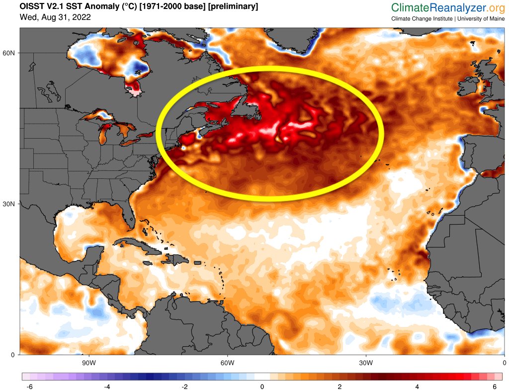
The North Atlantic is experiencing an unprecedented marine heatwave, with the region experiencing its warmest water temperatures in recorded history.
This could have major implications for marine ecosystems and recurving hurricanes advancing towards Europe this fall.
 
CO2 sensitive areas & Persistent Marine Heatwaves (PMHW)


Based on a joint analysis of satellite measurements, BGC-Argo observations, reconstructions derived from machine learning algorithms, and a state-of-the-art numerical model of the global ocean, produced by Mercator Ocean International, the study highlighted an absence of essential knowledge on marine heatwaves and their effect on the CO2 sensitive areas.
Starting from the latter, it has been observed that the ocean is currently absorbing about 25% of anthropogenic CO2 emissions, thereby providing a significant ecosystem service to mankind by mitigating global warming.
The CO2 fluxes occur at different zones throughout the ocean: carbon dioxide is mainly absorbed at high latitudes, while it is released back to the atmosphere in low latitudes.

Marine heatwaves can occur at different locations in the ocean, and their magnitude and frequency have increased over the last couple of decades, with harmful impacts on ecosystems, marine industries and human activities.
In the paper, the authors focused on intense and long-lasting marine heatwaves (Persistent Marine Heatwaves, PMHW).
They show that PMHW occur in major CO2 uptake and release areas, the so-called CO2 sensitive areas, as shown in the picture below.


The strongest and most significant impact of PMHWs on the air-sea exchange of CO2 occurs in the Pacific Ocean, with a net decrease in the oceanic uptake of CO2 of 29 +/- 11 % in the North Pacific and a 40 +/- 9 % net reduction in CO2 release in the Tropical Pacific.

These results provide new insights into the interaction between marine heatwaves and carbon dioxide sensitive zones.
They especially pave the way for future investigations on its evolution under climate change.

Wednesday, August 31, 2022

Earth broke the record for the shortest day since atomic clocks were invented


From CNN by Megan Marples
 
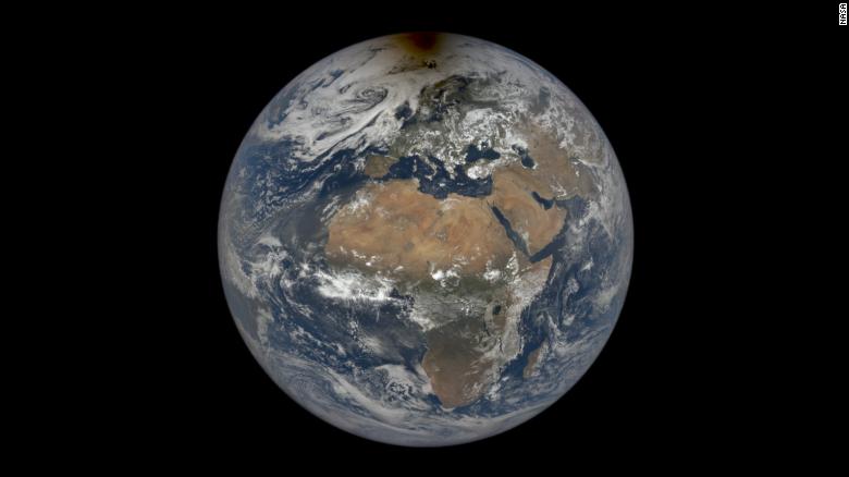
Earth completed its normal 24-hour rotation 1.59 milliseconds fast on June 29, breaking the record for the shortest day in modern history. 
 
If you feel like there's less time in the day, you're correct.
Scientists recorded the shortest day on Earth since the invention of the atomic clock.
Our planet's rotation measured in at 1.59 milliseconds short of the normal 24-hour day on June 29, according to the International Earth Rotation and Reference Systems Service, an organization in charge of global timekeeping.

A rotation is the length of time the Earth takes to spin once on its axis, which is roughly 86,400 seconds.

The previous record was documented on July 19, 2020, when the day measured 1.47 milliseconds shorter than normal.
The atomic clock is a standardized unit of measurement that has been used since the 1950s to tell time and measure the Earth's rotation, said Dennis McCarthy, retired director of time at the US Naval Observatory.

Despite June 29 breaking a record for the shortest day in modern history, there have been much shorter days on Earth, he said.

When dinosaurs still roamed the planet 70 million years ago, a single day on Earth lasted about 23 1/2 hours, according to a 2020 study published in Paleoceanography and Paleoclimatology.
Since 1820, scientists documented Earth's rotation slowing down, according to NASA. In the past few years, it began speeding up, McCarthy said.

Why is the speed increasing?

Researchers do not have a definitive answer on how or why Earth is turning slightly faster, but it may be due to glacial isostatic adjustment, or the movement of land due to melting glaciers, McCarthy said.
Earth is slightly wider than it is tall, which makes it an oblate spheroid, he said.
The glaciers at the poles weigh down on the Earth's crust at the North and South poles, McCarthy said.
Since the poles are melting due to the climate crisis, there is less pressure on the top and bottom of the planet, which moves the crust up and makes the Earth rounder, he said.
The circular shape helps the planet spin faster, McCarthy said.
It's the same phenomenon that figure skaters use to increase and decrease their speed, he said.

When skaters stretch their arms away from their body as they spin, it takes more force for them to rotate, he said.
When they tuck their arms close to their body, their speed increases because their body mass is closer to their center of gravity, McCarthy said.
As Earth becomes rounder, its mass becomes closer to its center, which increases its rotational speed, he said.
Some have suggested a correlation with the Chandler wobble, McCarthy said. The axis our planet rotates on is not lined up with its axis of symmetry, an invisible vertical line that divides the Earth into two equal halves.
This creates a slight wobble as the Earth rotates, similar to how a football wobbles when it is thrown, he said.
When a player tosses a football, it wobbles slightly as it rotates since it often doesn't spin around the axis of symmetry, he said.
"If you're a really good passer in football, you line up the axis of rotation with the axis of symmetry of the football, and it doesn't wobble," McCarthy said.
However, McCarthy said the Chandler wobble likely does not affect the rotational speed of Earth because the wobble is due to the planet's shape.
If the planet's shape changes, it changes the frequency of the wobble, not its rotation frequency, he said.

Removing a leap second

Since researchers began measuring the Earth's rotational speed using atomic clocks, Earth had been slowing down its rotational speed, McCarthy said.
"Our day-to-day existence doesn't even recognize that millisecond," McCarthy said.
"But if these things add up, then it could change the rate at which we insert a leap second."
In the instances when the milliseconds build up over time, the scientific community has added a leap second to the clock to slow down our time to match Earth's, he said.
There have been 27 leap seconds added since 1972, according to EarthSky.
Because Earth is now rotating faster, a leap second would need to be taken away to catch our timekeeping up with Earth's increasing rotational speed, McCarthy said.
If the planet continues this rotational trend, the removal of a leap second likely wouldn't need to happen for another three to four years, he said.

Links :

Tuesday, August 30, 2022

Sailing is like religion in Annapolis. Black kids had been locked out.

Teens, from left, Cyrus Chambers, Rondell Franklin and Jayden Hill joined a sailing camp this summer in Annapolis, whose waterfront has become harder to access than ever.
(Michael Robinson Chavez/The Washington Post)

From WP by JoAnna Daemmrich

 
Barefoot and in borrowed life jackets, Jayden Hill and Rondell Franklin leaned back in their 12-foot dinghy, skimming alongside the sleek yachts and sightseeing boats of the Chesapeake Bay.

Neither had sailed before this summer, nor been so close to the Naval Academy’s rocky sea wall, the fenced-in luxury homes or the secluded private beaches of their unequal hometown.
Yet as they let out their sails, turning back toward Annapolis, both boys looked as comfortable as if they were chilling on a couch.

“It’s an incredible feeling,” said Rondell, 14, a soon-to-be high school freshman who lives in one of Annapolis’s public housing projects.
“When you play sports, you have to do everything at a certain pace.
With sailing, you can go on your own and take your time.”

Sailing is like religion in Maryland’s capital, where children from well-to-do families learn early at exclusive yacht clubs the way kids elsewhere might learn to ski.
But while Annapolis once had stretches of shoreline where anyone could fish or set sail, the small town now teems with tourists and nautically themed bars, its waterfront areas Whiter, wealthier and less accessible than ever.

Jayden and Rondell’s mentor, Thornell Jones, is among those seeking to turn back the tide.
Jones, 84, pulled together the money this summer to send them and two other boys to sailing camp at the Eastport Yacht Club, where Jones is one of the only Black members.
The club contributed scholarships for four more kids to attend its $450-a-week camps, which sell out months in advance.
And a nonprofit partnered for the first time with a sailing school to provide a week of training to a dozen children from Black and Latino communities.

“When you learn to sail as a kid, you learn everything about the water and the wind, and it becomes part of you,” said Jones, still spry despite his spectacles and graying mustache.
“If you don’t have access to the water, if you don’t have any connection to people on the water, it’s harder to imagine.”
 
Cyrus Chambers, 15, left, watches his friends Jayden Hill, 15, and Rondell Franklin, 14, sail in Annapolis. “It’s an incredible feeling,” Rondell said.
(Michael Robinson Chavez/The Washington Post)

Thornell Jones, 84, who helped send teen boys to sailing camp this summer, preaches that the sport can open opportunities for scholarships and employment.
(Michael Robinson Chavez/The Washington Post)
 
Jones could imagine it growing up.
Sailing was his boyhood dream, conceived when he was 5 years old and spotting white-sailed boats gliding past a New Jersey riverbank, a sight he still calls “magical.” But in the Jim Crow 1940s, no program would teach him.
A half-century later, Jones retired from his IBM marketing job and moved to Annapolis, determined to sail at last.
 
But even as he organized Friday night races and joined the U.S.
Coast Guard Auxiliary, Jones discovered that in “America’s Sailing Capital,” the sport was not much more integrated than in his youth.
He was dismayed that children growing up a few blocks from creeks dotted with elegant sailboats had never noticed them.

That’s a systemic problem, noted Deni Henson, who grew up here in the 1960s, when the town of 41,000 was low-key and working-class, home to oystermen and crabbers.
Henson recalled an “idyllic type of childhood” catching crabs and swimming along the Eastport peninsula, before soaring property values forced out most of its Black community.
Fences went up, restaurants opened, and as multimillion-dollar homes replaced cottages and working boatyards, informal access to the water gradually disappeared.

“If you’re the average African American kid here, you live on a peninsula surrounded by the water, but you can’t get to the water,” said Henson, who still owns her grandparents’ home, next to an oyster plant that’s now a museum.
“You can’t just go down to the beach like I did and swim.”

 Teens rig up 12-foot sailboats to take out onto the Annapolis bay. Development has crowded out the informal spots where kids used to fish or set sail.
(Michael Robinson Chavez/The Washington Post)

Over the past few summers, as pandemic-era crowds overran public piers, coves and the downtown harbor nicknamed “Ego Alley,” Annapolis officials have searched for solutions.
Earlier this month, conservationists celebrated saving a fragment of a historic Black beach for a park.
The city has launched a water-equity study and made plans for new kayak launches and an electric ferry.

But only so much can be done, since almost all of the town’s 17 miles of shoreline is privately owned.
In Eastport, tensions over water access are rising as fast as the high-end, gated-off housing, and waterside neighbors are installing bushes to block coves where some used to paddle.

“Every rich person wants to protect their access to the water,” said Diane Butler, 60, a sailor who serves on the city’s planning commission.
“They take five feet on one side, five feet on another, and there’s less left.”

A public sailing school could broaden opportunities and rival the powerful yacht clubs, which run the high school teams and charge junior membership fees.
But some Annapolis leaders question whether the city could afford one.

“The issue isn’t access to the water,” said former mayor Ellen Moyer, who worked to preserve the street-end coves, including the handful now in dispute.
“It’s the equipment, maintenance and liability.”

Kids in Annapolis typically learn to sail at exclusive yacht clubs Annapolis leaders say a public sailing school might be too costly to maintain.
(Michael Robinson Chavez/The Washington Post)
 
Jones has tried for years to introduce more kids to sailing, especially those living in areas tourists rarely see.
He’s knocked on doors and talked to donors.
He’s taught fifth-graders contours of the Bay.
He’s preached that knowing how to sail can change lives, opening opportunities to high school teams, college recruitment, or well-paying jobs.

“Too many young people here don’t understand there’s a marine industry here desperate for workers,” he said.

Equally important, Jones hoped that by sailing for three weeks, through sunshine and wind, choppy water and the occasional rainstorm, the boys would emerge proficient enough to teach younger kids.
He envisions developing “a nucleus of young Black sailors” to transform the sport for the next generation.

Tyler Womack, 15, prepares to head onto the bay July 21.
(Michael Robinson Chavez/The Washington Post)
 
Jones’s teens had to conquer the tedious art of untangling ropes.
(Michael Robinson Chavez/The Washington Post)

In the stifling heat of a recent morning, Jones’s four teenagers clustered with younger campers in a gravel lot, their expressions serious as they fumbled with knots.
Two instructors, competitive sailors though barely older, demonstrated how to attach a lightweight spinnaker to sail off wind.
Jayden, 15, sweating as he struggled with the kite-like sail, joked: “I was ready to cry if we were going to do this every day.”

Jones kept track of the boys’ progress as they conquered the tedious art of untangling ropes, raising sails and memorizing courses.
He dropped by with sandwiches, cold drinks and nautical charts to teach them navigation.
Though local nonprofits regularly organize tours of ships and sailing excursions on private boats, Jones didn’t want to settle for a tourist outing.
He wanted the boys to handle boats themselves.

Not many young African Americans do.
A 2020 nationwide survey of college sailors found that less than 1 percent were Black.
The National Sailing Hall of Fame, which left Annapolis in 2019 for Newport, R.I., only inducted its first Black sailor last year.

“Coming up in the sport, I didn’t see a lot of people like me,” said Preston Anderson, 22, who sailed for Bowdoin College and organized the diversity task force that orchestrated that poll.
“We’re really trying to find ways to attract new sailors, because you never know: You could have that walk-on on your team, and in four years, they could be an all-American.”

Jayden Hill, center, gets more than a sip of water from Cyrus Chambers, right, before they set sail.
A 2020 nationwide survey of college sailors found that less than 1 percent were Black.
(Michael Robinson Chavez/The Washington Post)
 
Ky’Niya Henson, 13, might be one.
The eighth-grader, who is not related to Deni Henson, lives in a ground-floor apartment at Harbour House, a housing project that has no water views despite its name.
Though she loves to swim, she avoids her community pool, worried about broken glass on the deck.

Three years ago, a mentor introduced Ky’Niya to sailing and helped her win scholarships to the Eastport Yacht Club.
She initially felt shy among the other campers, in their Vineyard Vines swimsuits and proper boating shoes.
Now, she says, she wants to sail all her life.

“It’s just so open.
You see the water, and trees, and everything you don’t see on land,” Ky’Niya said.
“It makes me feel really free.”

Jones’s boys felt the same.
On the water, they came to savor a quiet that can be elusive in town.
“It’s peaceful,” said Rondell, who lives in Robinwood, where during the second week of camp a man and woman were shot outside their apartment.

But the boys were most exhilarated by their ability to control a boat, to chart their own direction and “go fast” on windy days.

“We didn’t know much about it,” said Jayden, recalling his apprehension during Jones’s first lessons.
But “especially now that we’re going out on the water, I just love it.”
 
Sailing instructor Jack Wigmore, left, goes over the racing course for the campers in July.
(Michael Robinson Chavez/The Washington Post)
 
Near the end of their final week, the coaches arranged a mock race.
As the eight campers set out, trying to remember a complicated two-mile course, Jayden and Rondell drifted far behind.
Close to the channel marker, though, a gust of wind snapped them to attention.
With their coaches shouting directions, Jayden yanked the tiller, Rondell snapped the jib and they surged into the lead.

Their advantage would be short-lived as the wind shifted, but neither seemed to mind.
Rondell’s thoughts were turning toward his first year at St.
Mary’s High School, where he figured he would be too busy with football and basketball to join the sailing team.
Jayden was looking ahead to football tryouts at Annapolis High; he announced he might sail “after I retire.”

Jones had other plans for them.
“Triumphant” at the boys’ progress, he was already planning on signing them up for yacht club races, introducing them to paddleboard companies looking for workers, and another summer of lessons so they could become junior instructors.

The camp was three weeks, but the title, Jones had decided, was lifelong: Like him, they are sailors.

Links :

Monday, August 29, 2022

Scientists set for ocean crisis debate 150 years after ‘extraordinary’ expedition

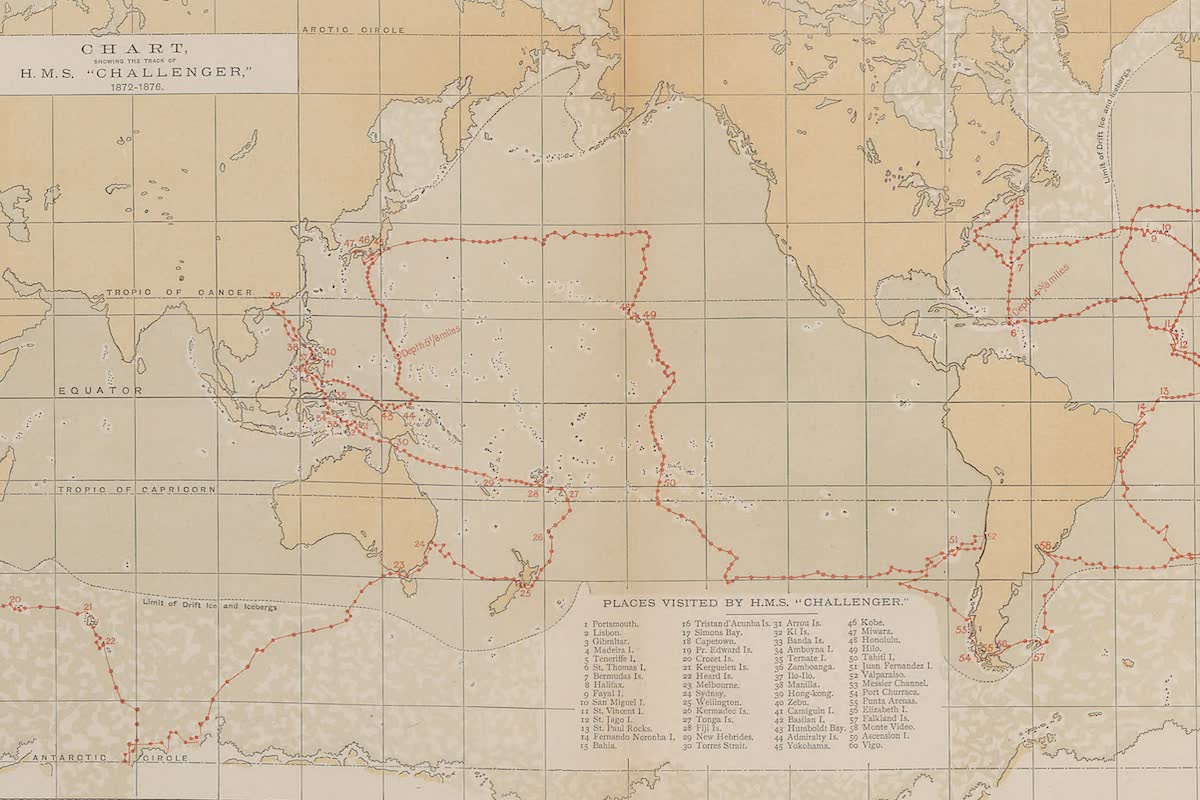
Trace of the HMS Challenger 1872-1876

From The Guardian by Robin Mckie

A century and a half after the Challenger mission transformed our understanding of the seas, researchers meet to tackle the latest threats

In a few days, several hundred researchers will gather in the UK to debate the crises facing the oceans – and to pay tribute to the expedition that first opened them up to scientific scrutiny.

Exactly 150 years ago, the Challenger expedition began a transformation in our understanding of the seas.
It revealed the existence of myriad forms of life at every depth and showed the ocean floor was not a featureless plain, as then thought, but was peppered with mountain ranges and deep trenches.

“We now know that the oceans play a fundamental role in driving Earth’s chemical, physical and biological processes,” said Nick Owens, director of the Scottish Association for Marine Science.
“They are crucial to the health of the planet and they are suffering from multiple threats today.
Challenger began that understanding, and it is appropriate that we mark the expedition’s 150th anniversary by comparing the state of the oceans then and now.”

When Challenger set sail, the seas were hardly affected by global warming; acidification caused by the absorption of carbon dioxide was not a problem; and the millions of tonnes of plastic that now pollute our seas remained a distant threat.
“The picture of the oceans that was revealed by Challenger provides us with a perfect baseline for looking at the state of our seas today,” said Owens, who will speak at the Challenger 150 conference which opens in London on 6 September.

Challenger sailed from Sheerness in December 1872 with a company of 250 sailors, engineers and marines – plus six scientists led by the Scottish naturalist Sir Charles Wyville Thomson.
Over the next four years, the vessel, which was fitted with a steam engine for dredging, sailed 68,890 nautical miles across the Pacific, Atlantic and Southern oceans; took 133 scoops from the ocean floor; carried out 492 deep-sea soundings and made 263 serial water temperature observations along its route.

 
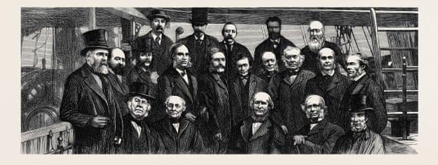
The scientists and backers of the original Challenger deep sea expedition.
Photograph: Artokoloro/Alamy


Apart from measuring sea depths, temperatures and currents, the expedition collected marine life from every part of the ocean.
More than 100,000 species were collected, preserved and returned to the expedition’s headquarters in Edinburgh.
It took a further 20 years to study these specimens, among which more than 4,700 new species of plants and sea life were discovered.
The final report, completed by John Murray after Thomson’s death in 1882, ran to 50 volumes.

“It was an extraordinary achievement,” said the marine researcher Adrian Glover of the Natural History Museum, one of the hosts of the Challenger 150 conference.
“Essentially, the Challenger expedition was the first multidisciplinary international science project.
“Until then, science tended to be carried out by individuals working in small laboratories.
Challenger changed that.
It tackled geology, chemistry, biology and a host of other disciplines.
It led to the birth of international interdisciplinary projects that now form the mainstay of research into topics such as climate change.”

At the time, most scientists thought the deep ocean floor was utterly uniform: a vast, flat expanse, filled with soft mud, said Erika Jones, curator of navigation and oceanography at the National Maritime Museum, Greenwich.

“Challenger showed this was definitely not the case.
It came back with these amazing charts that showed mountain ranges, valleys and vast trenches deep below the waves.” 
The deepest of these is now known as the Challenger Deep.
It lies 10,900 metres below the surface in the western Pacific Ocean and is the deepest-known point on the surface of the Earth.

It was also thought that the deep ocean could not support life because it was too dark and too cold, and pressures were far too great.
Challenger changed that view as well, added Jones, whose book, The Challenger Expedition: Exploring the Ocean’s Depths ,will be published in October.

The species discovered by Challenger ranged from tiny shellfish to strange fish like the stargazing seadevil, Ceratias uranoscopus.
However, the Challenger discovery that may have the greatest impact in coming years looked undramatic at the time.
Dredging the Pacific seabed, the expedition brought up small nuggets of dark material covered with faint indentations.
“These were polymetallic nodules, and we now know they litter the seabed in their trillions,” said Glover.
The first nodule found by Challenger is on display in the Natural History Museum, he added.

These nodules are rich in manganese, nickel, cobalt and copper – used for making the electric cars, wind turbines and solar panels that are needed to replace the carbon-emitting lorries, power plants and factories wrecking our climate.
Mining companies say their extraction should be an international priority.
By dredging up nodules from the deep, we could help to halt the scorching of our planet’s ravaged surface, they argue.

Many marine scientists disagree.
“It is hard to imagine how seabed mines could feasibly operate without devastating species and ecosystems,” says UK marine biologist Helen Scales – a view shared by David Attenborough, who has called for a moratorium on all deep-sea mining plans.

 
The deep oceans were revealed by the Challenger expedition.
Photograph: Hoiseung Jung/Getty Images/EyeEm

Along with overfishing and climate change, the issue will be debated at the conference.
Mining companies say it should be relatively straightforward to suck up the nodules that litter the seabed.
Many marine biologists disagree.
The impact could be catastrophic, they say, though they acknowledge that this message can be difficult to get across.

“What is scary from a scientific point of view is that it is so difficult to demonstrate to the public how important these environments are for the health of the planet in terms of global nutrient cycling, carbon capture, and maintaining biodiversity,” said another keynote speaker, the marine chemist Katherine Duncan, of Strathclyde University.
“Images of the destruction of rainforests have a visceral impact but those of the ocean floor do not have that effect. A sponge is not as photogenic as an orang-utan.”
 
Yet the seabed has a lot to offer humanity, Duncan insisted.
Her research involves a process known as pattern-based genome mining which she has used to study sediment cores extracted from the ocean floor 4,000 metres deep off the coast of Antarctica.

This work has already revealed the existence of two new species of marine bacteria, Pseudonocardia abyssalis and Pseudonocardia oceani, which make antimicrobial compounds and could one day be used to make new ranges of antibiotics.

Although a relatively new science, research on marine organisms has already created dozens of effective drugs.
Examples include the sea squirt Ecteinascidia turbinata which attaches itself to mangrove roots: it was found to have anticancer properties and led to the development of Yondelis, a sarcoma and ovarian cancer drug.
Similarly, an extract from the sea snail, Conus magus, has been used in synthetic form to create Prialt, a chronic pain drug.
Corals, sea slugs, marine worms and molluscs have also been used to create promising medicines.

“The worry is that if we begin deep-sea mining without proper controls, we run the risk of destroying invaluable sources of medicines for the future,” added Duncan.

Other threats to the health of the oceans include overfishing.
More than 150 million tonnes of fish are caught for human consumption every year, and it is now estimated that a third of the planet’s fish stocks are being exploited unsustainably.

However, it is climate change that is the ultimate threat, Owens said.
“The oceans drive so many planetary processes and they are also absorbing most of the heat generated by our fossil fuel emissions.
In the end, there is only so much they can take, and from what we have learned about impacts over the past 150 years, it is clear they cannot take much more without there being significant impacts on the planet.”
 
Links :

Sunday, August 28, 2022

The floating devices turn waves into electricity

Developed by Australian startup company Wave Swell Energy, the UniWave200 converts wave energy into zero-emissions electricity.
The UniWave200 has launched at King Island, Tasmania and essentially acts as a floating power plant.
The device uses an oscillating water column (OWC), which is a sort of man-made blowhole.
As waves pass over it, the OWC rises and falls pushing air towards a turbine at the top, which in turn generates electricity.
The UniWave200 can be towed into any coastal area and connect to its local power supply.
This technology could be particularly useful for more low-lying nations who are more prone to issues pertaining to sea level rise and severe storm surge events.

Developed by Sea Wave Energy Limited (SWEL), the ‘Waveline Magnet’ is a low cost, climate-friendly alternative to non-renewable power sources.
The spine-shaped floating device converts wave power into electricity.
While the device is still in its early stages, a prototype was taken to Larnaca Bay in Cyprus for open-sea trials in November 2021.
 
Links :