Cyanea capillata (aka Lion's mane), one of the most beautiful jellyfish in the Arctic. The lion's mane of tentacles have gone a little bald, but the jellyfish still looks amazing. pic.twitter.com/PUoTnfYpvQ
Arctic shipping traffic is on the increase. One day, these ships will be autonomous. New technology that can remove rain, snow and fog from the images produced by the ship’s cameras and sensors will increase safety in extreme conditions.
Imagine an autonomous ship sailing through one of the world’s most extreme ocean areas. Sea ice is everywhere. Fog, snow or rain make visibility extremely poor. Just like ship captains see through their eyes, autonomous navigation algorithms perceive the world through sensors, and bad weather is just as impenetrable for sensors as it is for sea captains.
Getting rid of poor visibility
With the rise of Arctic shipping, something that can remove the bad weather from the images so the algorithms can see the surroundings as if it were a clear, sunny day could be extremely useful. Now, PhD candidate Nabil Panchi at NTNU’s Department of Marine Technology has developed an algorithm that can do just that.
“We have put in place a new piece of the big puzzle for better modeling of sea ice,” Panchi said.
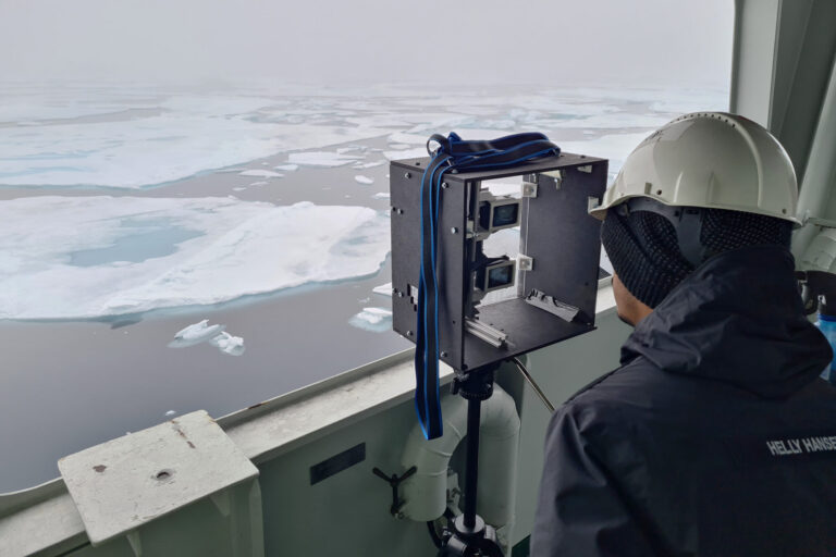
Behind the clouds, the sky is always blue, and on the other side of bad weather, there is always a clear view. Nabil Panchi adjusts the cameras on board the research ship Kronprins Haakon. Photo: Daniel Albert, SINTEF.
Current AI algorithms work well on clear images, but they struggle when images become blurry or degraded due to bad weather.
Panchi, who is also a naval architect, has used thousands of images from the Arctic to train the new algorithm so it filters out visual impediments such as rain, snow, and fog, as well as water droplets on the lenses of the cameras that many vessels are equipped with.
Panchi is affiliated with the DigitalSeaIce project, which is focused on multi-scale integration and digitalization of Arctic sea ice observations and prediction models. The main objective is to build a digital infrastructure that integrates regional sea ice forecasting models and local ice-related models with shipboard and satellite-based Arctic sea ice and environmental observations. Understanding the environment via images
“Our work is about understanding the Arctic environment through the use of images. We are creating algorithms that work in all weather conditions” says Panchi.
Overview of the scientific activities aboard Norwegian research vessel Kronprins Haakon, as part of the second GoNorth expedition during which scientists discovered a new hydrothermal field between Svalbard and Greenland.
His research is based on thousands of images taken on a voyage with the research ship Kronprins Haakon in the Arctic during the summer of 2023.
In collaboration with his academic supervisor, Associate Professor Ekaterina Kim, he recently published the article ‘Deep Learning Strategies for Analysis of Weather-Degraded Optical Sea Ice Images’ in the IEEE Sensors Journal.
Panchi and Kim are introducing two ways of helping ships travel more safely in bad weather in the Arctic, by “removing” the weather from images. One uses artificial intelligence to clean up the images, so that existing algorithms work as they should. A slightly more efficient way is to develop new algorithms that work during bad weather.
“Both strategies allow us to understand the Arctic in all weather conditions,” Nabil says.
Cleaned images already in use in cities
Algorithms that can remove weather from images have been in use for a long time, but primarily in urban areas. They are used to develop autonomous cars, and in security and camera surveillance.
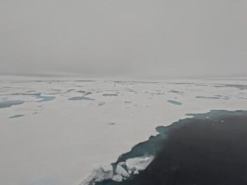
Current algorithms that analyze sea ice are largely based on images taken from ships in good weather conditions. The problem is that images from the Arctic are often unclear due to the fog, rain, and snow that are common weather conditions in these waters. These types of images are poor material for the existing algorithms that are designed to understand the Arctic environment.
The algorithms also need to be trained to analyze the type of ice surrounding the ship, so they can indicate where it is safe to break through the ice, and which areas the ship should avoid. The first open-access dataset of sea ice images
In order to remove fog and raindrops, algorithms must be trained to clean up weather-affected sea ice images. “This area of research had largely been ignored so far. The problem has been limited access to clear images from the Arctic – until now. We hope that our new open-access dataset helps in future development of weather resilient technology,” Panchi says.
Panchi’s supervisor Ekaterina Kim has worked extensively in the Arctic, and in recent years she has been exploring how AI can be adopted to solve some of the challenges that exist in polar regions.
The two NTNU researchers have now made the SeaIceWeather dataset publicly available online. It contains thousands of images and is the first open-access data set for sea ice.
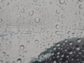
Rain on one, clear weather on the other. When fed with a weather image, the AI model removes the raindrops and produces a much clearer image of the ship’s surroundings.
Facilitating safer voyages
“There are very few open-access datasets of this type. A huge amount of work goes into making them. We hope they are used as much as possible,” says Panchi.
Rain on one, clear weather on the other. When fed with a weather image, the AI model removes the raindrops and produces a much clearer image of the ship’s surroundings.
Each picture comes in two versions: a ‘clean’ version with a clear view, and an unclear one due to weather conditions. NTNU researchers hope that the SeaIceWeather dataset will be used by more people and that it inspires them to collect these types of images.
Many of the users are researchers who are working on sea ice and navigation models, or dynamic positioning. These systems must work in all weather conditions, and the more images the algorithms are given to learn from, the more accurate the monitoring, ice warnings, and navigation will become – something which is very much in demand.
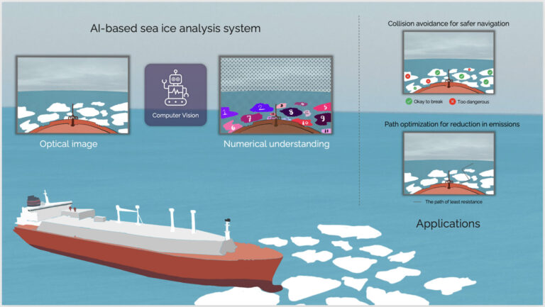
An AI-based system for sea ice analysis helps the crew understand the ship’s surroundings. “We can use this information to develop advanced systems to avoid collisions, for safer navigation and the best sailing routes possible. The latter will also help reduce emissions,” says PhD candidate Nabil Panchi (Illustration: Nabil Panchi) More ships – and inexperienced captains
Global warming is causing sea ice to melt, increasing the amount of Arctic shipping. More and more shipping companies are choosing these new routes that have now become ice-free. Between 2013 and 2019, ship traffic in the Arctic increased by 25 percent.
“It takes a lot of experience to navigate safely through sea ice. There are probably more ships in polar waters now than there are experienced sea ice captains. The system we have built can provide better assistance for people maneuvering the ships,” says Panchi.
Arctic sea ice has become thinner, cracks more easily, and can make massive ice ridges or hummocks. From the bridge of a ship, only one meter of ice might be visible sticking up above the surface, but not the 4-5 meters hidden below. The likelihood of dents and hull damage is high, and not all ships are built to break through ice.
An AI-based system for sea ice analysis helps the crew understand the ship’s surroundings. “We can use this information to develop advanced systems to avoid collisions, for safer navigation and the best sailing routes possible. The latter will also help reduce emissions,” says PhD candidate Nabil Panchi
At the same time, autonomous shipping holds the potential to revolutionize the shipping industry – making it more efficient and safer. According to Fortune Business Insights, the global autonomous ships market size is projected to grow from $6.11 billion in 2024 to $12.25 billion by 2032.
“We expect more autonomous technology on ships navigating through ice, and current systems need to be trustworthy in the extreme Arctic environment,” says Kim.
30 days of data capture
Panchi has trained the algorithms on two image datasets: one collected during the GoNorth voyage on Kronprins Haakon, the other obtained from online image databases.
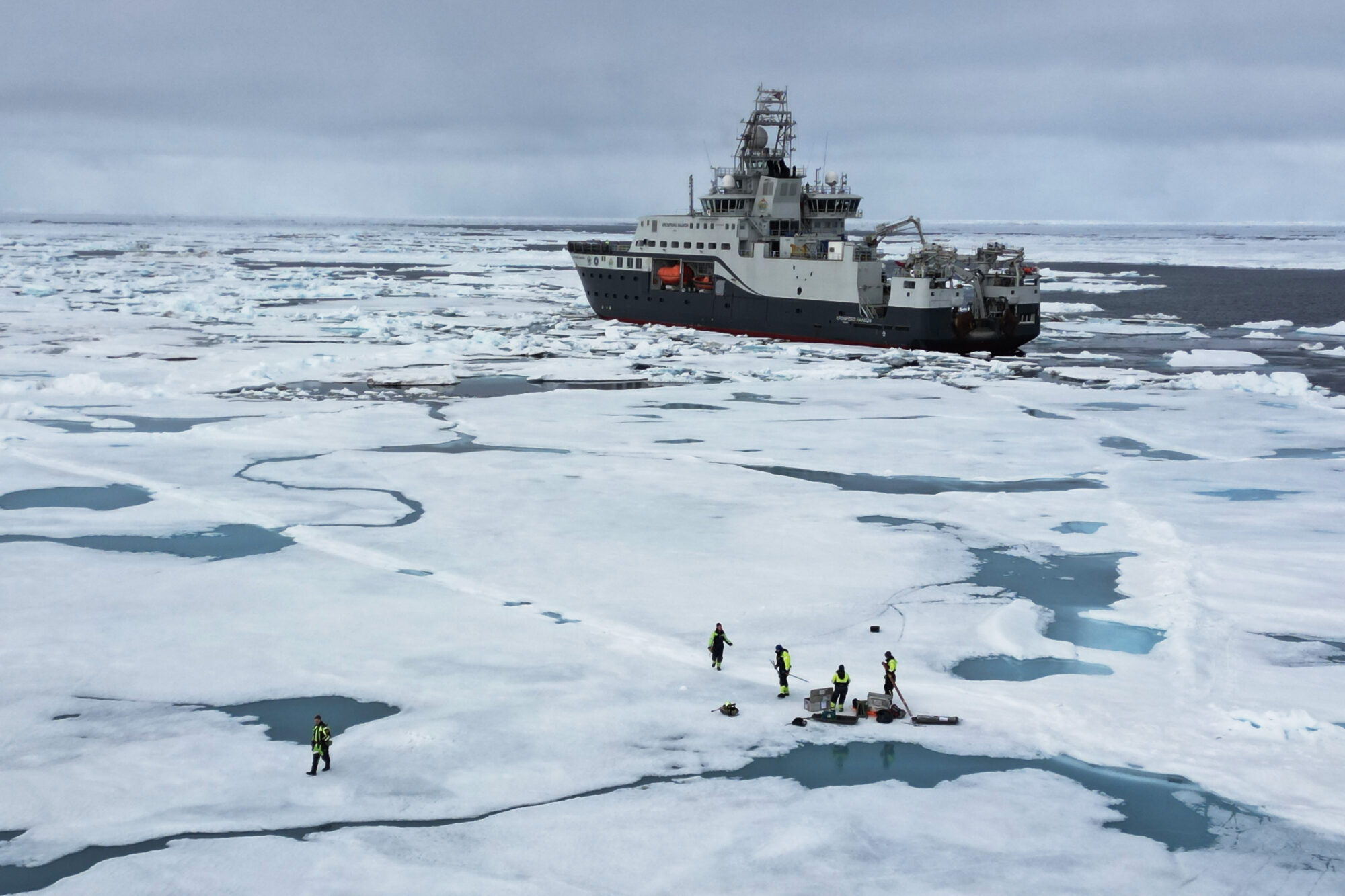
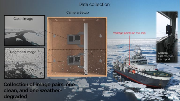
He mounted two cameras on one side of the ship, with one camera directly under the other one. The upper camera had a clear view, while they had mounted a transparent screen in front of the lower camera, which was sprayed with water to simulate raindrops on the lens.
The data collection set-up on board the research ship Kronprins Haakon in the Arctic.
The upper camera takes clear pictures, lcean, and the lower camera takes pictures with raindrops in front of the lens.
Illustration: Nabil Panchi. Background image: Daniel Albert, SINTEF/GoNorth.
In the observation room on the ninth deck, Panchi’s computer continuously downloaded the images of sea ice. For 30 days, he collected thousands of pairs of images, each of which consisted of one clear image and one covered with artificial rain.
Training algorithms
In total, the datasets consist of over 4600 clear images, most of them from the research voyage. Using algorithms, they created seven weather variants for each clear image: small, medium and large snowflakes, rainy weather, fog, and real and simulated raindrops on the camera lens.
Based on these variants, they then created the two datasets. One of them presents images that indicate what kind of ice is located around the ship. The other dataset divides the ice into different categories, such as ice floes, pancake ice, ice slush, drift ice, etc.
Three different image-cleaning algorithms were trained on the datasets, and when the researchers compared the results with the clear images, they could easily tell which algorithms were most accurate in relation to the different types of weather.
Only daylight and three types of weather
The method is limited in that all the images are taken in broad daylight and involve only three types of weather conditions. Panchi points out that since the Arctic is in darkness from September to March, similar images should ideally be collected during the winter. However, it is also fully possible to use Augmented Reality (AR) and create an artificial winter or night-time version of the existing images.
“So far, it’s mainly researchers who can use what we have done, but we hope that more people will use it in the future. There are many factors affecting when this will actually happen; it may take up to 5 years before the models can be used commercially. They must then be of a quality that make them a fully reliable assistant for ship management,” Nabil said.
Reduced emissions
The largest ships use enormous amounts of fuel. They sometimes have to sail back and forth into the ice in order to break through, which requires a lot of energy.
“If you fully understand the conditions surrounding the boat, you or AI can plan the route and save time, effort and therefore emissions. It will also make shipping safer. There are a growing number of tankers carrying liquefied natural gas and other cargo sailing through the Arctic. So far, there haven’t been any oil spill incidents, but if one were to occur, it would have serious consequences,” says Panchi.
A lot of unused image data
Monitoring polar waters is also important with regard to climate change. Many ships have cameras and sensors that monitor their course. There are lots of ships producing images, but hardly any of these images are available online. According to Panchi, most of the images end up in maritime data archives, and – apart from a few insurance cases – are never used.
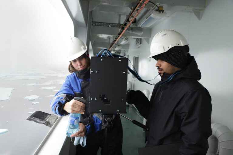
On the research voyage. PhD candidate Nabil Panchi (right) adjusts the camera, while PhD candidate Alexandra Pliss sprays water droplets on the screen in front of one of the camera lenses. Photo: Daniel Albert, SINTEF.
“We see great opportunities in extracting useful data from these images. One of our goals is to develop algorithms that can be improved in real time, on site. Improving how we monitor Arctic waters will benefit society. It will provide a better basis for forming policies, and for sustainable and safe use of Arctic waters,” Panchi said.
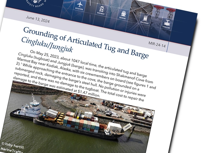
The National Transportation Safety Board has released its report on the grounding of an ATB cargo barge on a rock just off Kodiak Island last year.
The casualty was caused by improper use of an electronic chart system (ECS), according to NTSB: the master overlooked the symbol for a submerged rock, and the chart system's auto-checking function was not used to verify the safety of the voyage.
Area where the Cingluku/Jungjuk grounded, as indicated by a circled X. (Background source: Google Maps)
On the morning of May 22, 2023, the ATB tug/barge combination Cingluku / Jungjuk left the small port of Togiak, Alaska, headed for Seward.
The Cingluku had supplies on board for another vessel, and planned to rendezvous in Shakmanof Cove on Kodiak Island.
The barge was unladen and partially ballasted, and was drawing about six feet of water at the stern.
Approximate voyage trackline of the Cingluku/Jungjuk.
(Background source: Google Earth)
On May 23 at midday, as Cingluku transited False Pass, the captain - a 20-year veteran of the towing industry - laid out a course to Shakmanof Cove using the tug's electronic chart system.
It was his first time on a voyage into the remote bay on Kodiak's northern coast.
The tug continued on through the rest of the day and all of May 24, arriving off Kodiak on the morning of the 25th.
Track of the Cingluku/Jungjuk as it approached Shakmanof Cove, overlaid on NOAA ENC US4AK5PM.
(Background source: NOAA ENC as viewed on Made Smart automatic identification system)
The United States Coast Pilot 9 (Alaska) noted a rock in the area where the ATB grounded stating, “Kizhuyak Point: A rock, which uncovers about 4 feet, is 400 yards north from this point. Shoal water extends 300 yards north of the rock.”
The tug approached Shakmanof Cove at about 1030 hours in the morning, and the mate joined the master on watch.
Two deckhands and the engineer were stationed on the bow in preparation for landing, but had little forward visibility because of the barge's large bow ramp.
At about 1047, as the ATB rounded Kizhuyak Point, the barge ran aground on a submerged rock about 400 yards off the shoreline.
The tug was not affected, and its ATB coupling to the barge remained in place. Alaska's strong tides came to the rescue and lifted the barge off about six hours later.
The crew remained in the cove to await good weather and arrange for a dive inspection.
Divers found no signs of penetration of the hull, and there was no flooding in the barge's void spaces.
After the ATB reached Seward, it was drydocked for a class inspection.
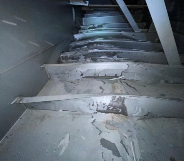
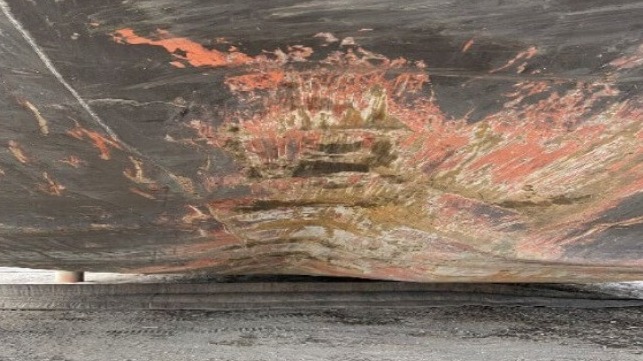
The damage included a 16-20 foot long dents in the bottom plating and frame damage in the same area, in way of the centerline forward ballast tank.
The total estimated cost of repairs came to about $1.5 million.
Hull damage along the bottom of the barge (NTSB)
Frame damage inside the ballast tank (NTSB)
While the rock was not visible from the surface, it was a charted hazard, and it appeared on the NOAA chart that the master had used to prepare the voyage plan.
ENC US4AK5PM, as viewed by investigators using an equivalent ECS.
The chart shows an isolated danger symbol over the rock that the ATB struck.
(Backgroundsource: NOAA ENC as viewed on Rose Point ECS)
RNC for the area near Shakmanof Cove.
The symbol for the rock in the area of the grounding is indicated by a red circle.
(Background Source: NOAA Chart 16594, 14th Edition, January 2015)
ENC US4AK5PM, for the area near Shakmanof Cove, as viewed by investigators using an equivalent ECS. The asterisk symbol for the rock in the area of the grounding is indicated by a red circle.
(Background source: NOAA ENC as viewed on Rose Point ECS)
The tug's master and mate used the common ECS platform Rose Point, often found on working vessels in Alaska.
The system has a depth contour safety feature that highlights shoals and hazards based on the vessel's draft, but the crew told NTSB they didn't use it.
The reason, they said, was that "the soundings don't really mean anything" in Western Alaska, where much of the survey data dates back many decades.
The software can also highlight isolated dangers, like this submerged rock, but that option was turned off.
The company's policy in its SMS did not require the use of these features, and the firm did not give its crews formal training on the use of the software.
US4AK5PM NOAA visualizations
"When investigators viewed the area on an equivalent ECS, the asterisk marking the rock was displayed alongside soundings of similar size and color, so it is possible that the captain mistook the asterisk for a depth sounding or other chart information when plotting and reviewing the route," concluded NTSB. "Using other available resources, such as the Coast Pilot, would have helped the captain in identifying the rock when planning and reviewing the route."
Scientists have found a clever way to generate hydrogen straight from salty seawater.
This could be another step towards a clean energy future, if renewables power the process.
The new device makes a few chemical modifications to existing technologies, making it possible to extract hydrogen from untreated, unpurified seawater – which could alleviate concerns about using precious water supplies.
"We have split natural seawater into oxygen and hydrogen… to produce green hydrogen by electrolysis, using a non-precious and cheap catalyst in a commercial electrolyzer," explains chemical engineer Shizhang Qiao of the University of Adelaide in Australia.
Traditionally, hydrogen fuel has been made using natural gas, but it can also be made through electrolysis.
Electrolysis is a water-splitting reaction that uses electricity to bump hydrogen atoms out of elbow-shaped water molecules, and an electrolyzer is a device in which that happens.
Right now, this process can be achieved using electricity from fossil fuels or from renewable energy sources, but both systems require fresh water.
Finding a way to achieve electrolysis with seawater could make the future of green hydrogen fuel production far more sustainable.
Researchers have been trying to develop an alternative to commercial electrolyzers, which only work with purified fresh water, out of concern for water shortages.
Accessible freshwater makes up just 1 percent of Earth's total water, but there is a virtually limitless supply of seawater that could be used.
While concerns about water scarcity are valid, recent estimates suggest that the amount of water needed to sustain future hydrogen use is far, far less than the trillions of liters of water used to extract and burn fossil fuels today.
Scientists are still mindful of the environmental impacts, though.
For decades they have been trying to develop devices to make hydrogen from seawater but kept running into several hurdles.
When popped into an electrolyzer, unwanted chlorine ions in seawater erode the catalyst materials meant to drive the hydrogen-yielding, water-splitting reaction.
Massive insoluble precipitates also form, blocking reaction sites and hindering large-scale production.
The new system developed by Qiao and colleagues avoids both these problems.
As described in their new paper (Nature Energy), the researchers layered a hard Lewis acid substance over a series of common cobalt oxide catalysts to split water molecules.
In a series of tests, the modified catalysts resisted chlorine attack and prevented any precipitates from forming. "This is a general strategy that can be applied to different catalysts without the need for specifically engineered catalysts and electrolyzer design," write the researchers in their published paper.
While it sounds promising, the decades-long effort to develop seawater electrolyzers should serve as a reminder of the challenges ahead in commercializing this or any other technology. "Direct seawater electrolysis without the purification process and chemical additives is highly attractive and has been investigated for about 40 years, but the key challenges of this technology remain in both catalyst engineering and device design," the researchers note.
Recent progress is encouraging, with this new device being one of manypromising attempts to generate hydrogen from seawater.
For instance, scientists from China and Australia recently developed a prototype device designed to float on the ocean surface and split hydrogen from seawater using solar energy.
Another prototype in the works takes a totally different approach, harvesting water from humid air before extracting hydrogen.
Of course, prototypes are a far cry from industrial-scale methods, so it's good to have a healthy mix of potential systems in the pipeline to see which ones deliver.
Qiao and colleagues are working on scaling up their system by using a larger electrolyzer. But many factors can make or break a potential technology.
Commercializing any process boils down to the cost of materials, energy inputs, and efficiency at scale – where small gains can make a big difference in how much hydrogen is produced.
Like any precious metal used in batteries or solar panels, it must be mined sustainably and recycled where possible.
Having tested the durability of their set-up, Qiao and colleagues think their modified catalysts can go the distance.
Their system can deliver similar outputs to a commercial electrolyzer under the same low temperatures and operational conditions. But with other researchers making strides to steadily improve the efficiencies of conventional electrolyzers, it really is anyone's game.
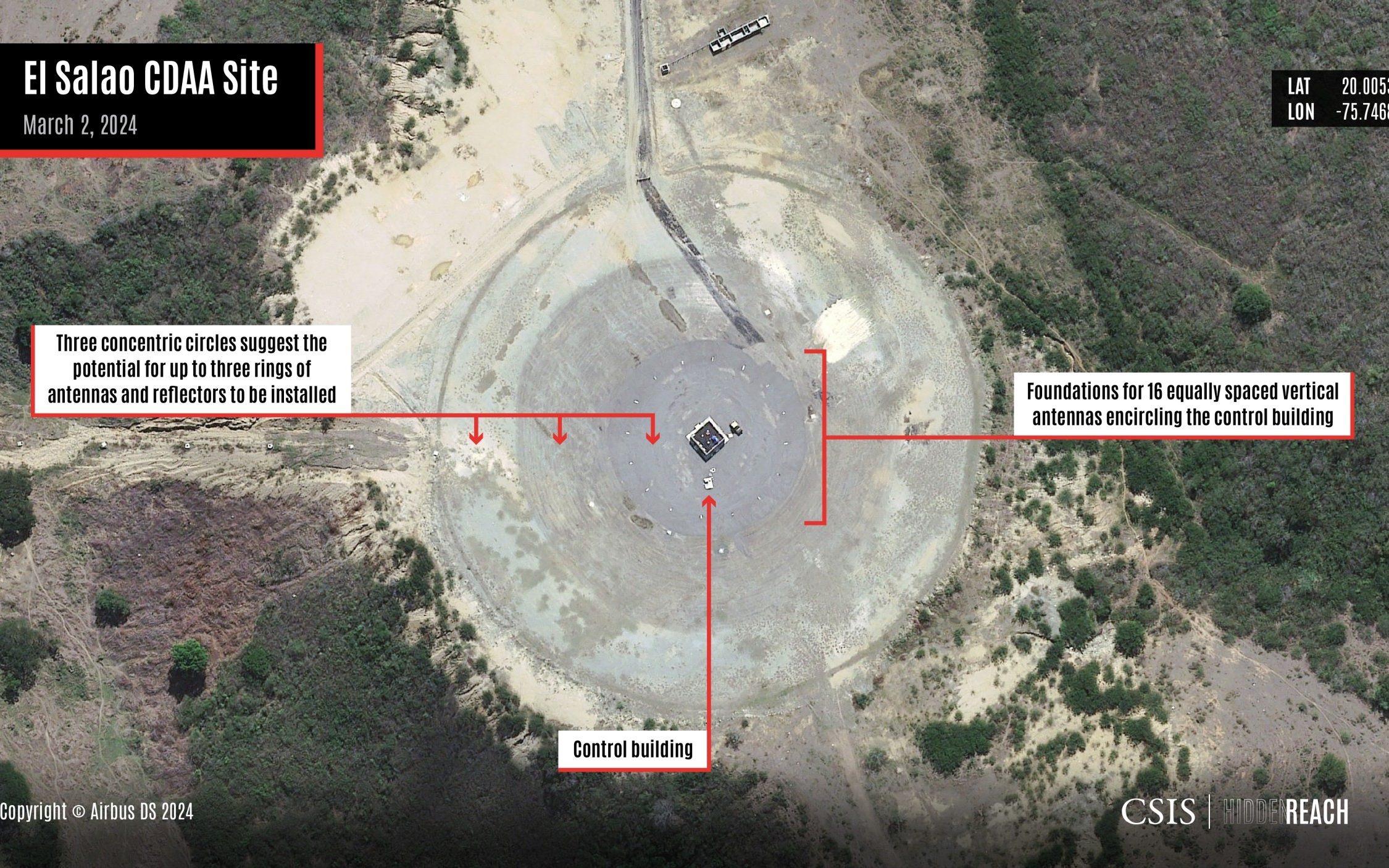
Cuba is building a new radar site likely to be capable of spying on the United States' nearby Guantanamo Bay naval base, a Washington think tank found using satellite images, the latest upgrade to the country's surveillance capabilities long thought to be linked to China.
The base, under construction since 2021 but previously not publicly reported, is east of the city of Santiago de Cuba near the El Salao neighborhood, the Center for Strategic and International Studies (CSIS) said in a report published on Monday and later referenced by the Wall Street Journal.
Cuban Vice Foreign Minister Carlos Fernandez de Cossio denied that Cuba was harboring Chinese military interests on the island. "(The) Wall Street Journal persists in launching an intimidation campaign related to #Cuba. Without citing a verifiable source or showing evidence, it seeks to scare the public with tales about Chinese military bases that do not exist and no one has seen, including the US embassy in Cuba," de Cossio said on social media.
Cuba's proximity to the U.S. and its southern military bases makes it a good location for China, Washington's top strategic rival, to seek to collect signals intelligence. CSIS called the new site a "powerful tool" that once operational will be able to monitor air and maritime activity of the U.S. military. The facility, known as a circularly disposed antenna array with a diameter of approximately 130 to 200 meters could be able to track signals as far as 3,000-8,000 nautical miles (3,452 – 9,206 miles) away, CSIS said.
A buoy is seen near the U.S. Naval Base in Guantanamo Bay, Cuba, June 2, 2017.
"Access to such an outpost would provide China with a highly strategic vantage point near Naval Station Guantanamo Bay," it said, referring to the key U.S. military base 45 miles (73 km) east of Santiago, Cuba`s second largest city. Such arrays were used heavily during the Cold War, but Russia and the U.S. have since decommissioned most of their sites in favor of more advanced technology, CSIS said. However, the think tank said China has been actively building new such arrays, including on reef outposts in the South China Sea.
Last year, Biden administration officials said Beijing has been spying from Cuba for years and made a push to upgrade its intelligence collection capabilities there beginning in 2019, allegations that both Beijing and Havana have denied. State Department spokesperson Vedant Patel declined to comment on the report, but told a briefing on Tuesday that the U.S. was "closely monitoring" China's presence in Cuba.
"We know that the PRC (People's Republic of China) is going to keep trying to enhance its presence in Cuba and the United States is going to keep working to disrupt it," Patel said without giving details. The White House National Security Council and the U.S. Defense Department did not immediately respond to requests for comment. China's embassy in Washington said the U.S. had repeatedly "hyped up" the idea of China's spying and surveillance from Cuba. "Such claims are nothing but slander," embassy spokesperson Liu Pengyu said. CSIS also said satellite images from March 2024 show Cuba's largest active signals intelligence site at Bejucal, located in the hills near Havana and linked to suspected Chinese intelligence activity for years, has undergone "major updates" in the past decade, calling it a "clear indication of an evolving mission set." "Collecting data on activities like military exercises, missile tests, rocket launches, and submarine maneuvers would allow China to develop a more sophisticated picture of U.S. military practices," CSIS said. It said certain radar systems installed in Cuba in recent years are in range to monitor rocket launches from Cape Canaveral and NASA's Kennedy Space Center, a likely interest for China as it seeks to catch up to U.S. space launch technology.
The Norwegian Ministry of Energy unveiled last week a proposal for a licensing round for seabed mineral exploration on the Norwegian continental shelf.
This keeps Norway on course to become the first country in the world to allow the mining of seafloor minerals.
The proposal aims to identify areas suitable for sustainable mineral extraction, contributing to the global push for green technologies.
The proposal delineates specific regions where companies can apply for exploitation licenses, initiating exploration and gathering data.
This step follows a strong parliamentary backing and the formal opening of areas in the Norwegian Sea and the Greenland Sea earlier this year.
“The world needs minerals for the green transition, and Norway is poised to lead in their sustainable extraction. We aim to balance resource management with environmental stewardship, starting with today’s public consultation,” Minister of Energy Terje Aasland said in a press release.
The consultation, open until September 26, 2024, encompasses 386 blocks, about 38% of the newly available area.
The Ministry plans to award licenses by mid-2025, adhering to rigorous environmental standards throughout the process.
As a part of the licensing procedure, applicants must submit detailed work programs, which the ministry will review in order to emphasize sustainable and responsible exploitation.
According to the ministry, the first steps towards seabed mineral extraction in Norway are being carefully monitored to ensure minimal environmental impact and alignment with the country’s long-standing commitment to sustainable ocean management.
Despite the government’s stated commitment to environmental concerns, groups such as Norway’s branch of the WWF have claimed seabed mining could cause irreversible damage.
“Norway positioned itself at the forefront of seabed mining initiatives, despite stark warnings from national and international experts and significant criticism from the European Union and global research communities,” the WWF said in a statement.
Graph by Fauna & Flora International 2021 via Planet Tracker.


 Hull damage along the bottom of the barge (NTSB)