Saturday, December 7, 2013

Fv25


Fv25 is our cold water surf film (finisterreuk.com)
It is cold water surfing as we see it, living and surfing within a cold water environment.
Filmed over 8 months, Fv25 will take you to the Outer Hebrides and Norway.
Filmed by award winning film maker Chris McClean and music composed by CJ Mirra.

Friday, December 6, 2013

Netherlands NLHO update : announcement of the issue date concerning the 1800 series


From 2013 onwards the Netherlands Hydrograpic Officeonly publishes a new edition of an 1800-atlas in the event of significant changes of the chart content.
This means that the eight 1800-serie charts have now different publication dates and regularly remain valid longer than one season, provided that they are weekly updated with the notices to Mariners (Ntm).
The eight 1800-atlases are no longer published at once as one pile.

With this message the Netherlands Hydrograpic Office informs us about the publication date of five 1800-atlases for 2014.
  • 1811 'Wadden Sea west sheet and adjacent North Sea Coast' and 1812 'Wadden Sea East leaf and adjacent North Sea coast' : second quarter 2014.
  • 1803 'Westerschelde and 1810 IJsselmeer, Edge Lakes and North SeaCanal' : third quarter 2014.
  • 1809 'Nieuwe Water route, etc' : fourth quarter 2014.

The other three 1800 serie-atlases remain valid, provided that they are weekly updated with the notices to Mariners. These are the :
  • 1801 NorthSea coast: Edition 2013
  • 1805 Oosterschelde, Veerse Meer: Edition 2012
  • 1807 Zoommeer, Volkerak et c., Edition 2012
In addition to paper 1800-series charts there is an increasingly use of additional electronic chart systems (ECS).
Mostly, these electronic charts are usually based on the 1800 series in which the ECS-producer or
customer makes the choice for the update frequency.
The Netherlands Hydrograpic Office has no supervision over these electronic charts (ECS) and emphasize the importance of a good voyage preparation in which the user becomes aware of the importance of the time stamp (actuality) of the chart and the differences in scale of the two product types.
The notices to Mariners are weekly published per atlas on www.hydro.nl
In addition, the brochure "BaZ mapped" is available for further practical assistance and interpreting and processing the NTM's.

Links :

Vast undersea freshwater reserves mapped


With the majority of Australia’s population living along the coast, the management of coastal groundwater resources is becoming ever more important.
Recent research of groundwater systems at the land–ocean interface has clearly shown the importance of acknowledging the connectivity between onshore and offshore parts of coastal aquifers.
This information is necessary to understand and predict the movement of groundwater and its dissolved solutes across a range of spatial and temporal scales.
Coastal aquifer systems do not terminate at the coastline, and nor is the coastline fixed in time.
Past changes of sea level and coastline migration still have an influence on the groundwater salinity distribution today.
This presentation reviews the current state of the science, and explains the need for more research on the offshore parts of aquifers, which may contain significant volumes of exploitable groundwater.

From ABC

Vast freshwater reserves are trapped beneath the ocean floor which could sustain future generations as current sources dwindle, say an international team of scientists.
In this week's issue of Nature they estimate 500,000 cubic kilometres of low-salinity water is buried beneath the seabed on continental shelves around the world, including off Australia, China, North America and South Africa.
"The volume of this water resource is a hundred times greater than the amount we've extracted from the Earth's sub-surface in the past century since 1900," says Australian lead author, Vincent Post, a groundwater hydrogeologist from Flinders University in Adelaide.
"Freshwater on our planet is increasingly under stress and strain so the discovery of significant new stores off the coast is very exciting," says Post, who is also with the National Centre for Groundwater Research and Training.
"It means that more options can be considered to help reduce the impact of droughts and continental water shortages."
UN Water, the United Nations' water agency, estimates that water use has been growing at more than twice the rate of population in the last century due to demands such as irrigated agriculture and meat production.
More than 40 per cent of the world's population already live in conditions of water scarcity. By 2030, UN Water estimates that 47 per cent of people will exist under high water stress.
Post says his team's findings were drawn from a review of seafloor water studies done for scientific or oil and gas exploration purposes.
Prior to this report Post says such undersea water reserves were considered to be rare.
"By combining all this information we've demonstrated that the freshwater below the seafloor is a common finding, and not some anomaly that only occurs under very special circumstances," he says.

Underwater aquifers

Post says the deposits were formed over hundreds of thousands of years in the past, when the sea level was much lower and areas now under the ocean were exposed to rainfall which was absorbed into the underlying water table.
When the polar icecaps started melting about 20,000 years ago these coastlines disappeared under water, but their aquifers often remained largely intact -- protected by layers of clay and sediment.
"In some case you have actually have fresh water under the sea, but in most cases it's a mixture between freshwater and sea water - we call that brackish water," says Post.
Post says the deposits are comparable with the bore basins currently relied upon by much of the world for drinking water and could cost much less than seawater to desalinate.
"For some areas it is economically viable to desalinate that brackish water and make it economically competitive with other sources of water recovery."
Post says similar technology to offshore oil exploration.
"You could drill from a platform or drill horizontally under the sea bed," says Post.

Challenges

But, Post says drilling for the water would be expensive, and Post says great care would have to be taken not to contaminate the aquifers.
He warned that they are a precious resource.
"We should use them carefully: once gone, they won't be replenished until the sea level drops again, which is not likely to happen for a very long time," says Post.
Water resources expert Dr Richard Davis of the Wentworth Group agrees.
While he says this "neglected resource" could become economically viable to obtain with the drop in desalination costs, humans don't have a good track record when it comes to exploiting the world's onshore groundwater resources, such as the Great Artesian Basin.
"We just squandered the water," says Davis, who was previously with CSIRO, the World Bank and the National Water Commission.
"In the Great Artesian Basin case we spent around 100 years pumping the water to the surface and letting it flow free and evaporate, using only a very very small fraction of what we tapped," he says.
As a result, says Davis, Australia has had to undertake a very expensive remedial program to try and cap the free-flowing bores to save water. He says there are similar stories in Africa and China.
"What concerns me here is that we don't take the same approach again," says Davis.
"Let's be slow, cautious and thoughtful about it this time and show how we can act responsibly if in fact the economics do stack up for the use of some of these aquifers."

Thursday, December 5, 2013

Canada to file Arctic seafloor claim this week

 Canada, Denmark, Norway, Russia and the United States claim overlapping parts of the region believed to be rich in hydrocarbons,
and have been rushing to gather evidence in support of their respective claims.
(Canadian Arctic Oil & Gas reference map from Pew)

From CBCnews

Some time this week, Canada is expected to make its case to the world to dramatically expand its boundaries by an area equivalent to the size of all three Prairie provinces.

Arctic topography / Arctic bathymetry
According to the US Geological Survey, the Arctic seabed is thought to hold about 90 billion barrels of oil and 30 percent of the world’s undiscovered gas resources.

Canada's deadline is Friday to apply to a United Nations commission for exclusive rights to what is likely to be another 1.7 million square kilometres of Arctic seafloor.
The application under the Convention on the Law of the Sea will be the culmination of a decade of work and more than $200 million in public money.

The lines on the map will have been drawn by scores of scientists working everywhere from Ottawa labs to ice camps off the northern shores of Ellesmere Island, peering under the stormy black waters to discern the shape and composition of sea floor thousands of metres below.

The effort required more than a dozen icebreaker voyages, as well as trips by helicopters, airplanes and an unmanned, remote-controlled submarine that spent days under the ice.

The effort to map the Arctic seafloor required more than a dozen icebreaker voyages, as well as trips by helicopters, airplanes and an unmanned, remote-controlled submarine that spent days under the ice.
(Vladimir Chistyakov/Associated Press)

With the co-operation of three Arctic neighbours — Denmark, Russia and the United States — more than 18,000 kilometres of sea-floor data was collected from a part of the globe less familiar than the surface of the moon.
"It was a huge effort and enormously challenging," said Michael Byers, an expert on Arctic and international law at the University of British Columbia.

The United Nations Convention on the Law of the Sea governs which nations exert what kinds of controls over their surrounding waters.
In addition to the 22-kilometre territorial waters and the 370-kilometre exclusive economic zones, coastal countries are allowed to claim additional sea floor if they can show their continental shelf extends beyond the economic zone.

A Canadian nautical map charts the Canadian coastline in Nares Straight which separates Ellesmere Island with Greenland.
The old Soviet Union may have been just as familiar with Canada's Arctic waters as Canadians.
Sections of Cold-War-era nautical charts obtained by The Canadian Press suggest that Russian mariners have for decades possessed detailed and accurate knowledge of crucial internal waterways such as the Northwest Passage.
Canada is to file a claim to expand its Arctic seafloor boundaries this week.
(Michael Byers/The Canadian Press)

Canada has previously released maps on the likely boundaries of its claim.

 Artur Chilingarov, the veteran explorer who led the expedition to plant a Russian flag on the seabed at the North Pole in 2007, told Russia's claim to a portion of the Arctic shelf 

Russia filed its claim in 2002 and Denmark released its last week.
The U.S. has not signed the convention, but has agreed to follow most of its articles.
Its boundary dispute with Canada involves the exclusive economic zone and doesn't directly impact Friday's claim.

Ice floes float in Baffin Bay above the Arctic circle from the Canadian Coast Guard icebreaker Louis S. St-Laurent on July 10, 2008.
(The Canadian Press/Jonathan Hayward)

Decision decades away

Conflicts are likely to be few.
One calculation puts the amount of overlap between claims at a mere 75,000 square kilometres out of millions and millions.
Rob Huebert, an Arctic expert at the University of Calgary, will be watching to see if Canada stretches its claim past the North Pole.
The geologic justification — an undersea mountain range called the Lomonosov Ridge that stretches north from Ellesmere Island — is there, he said.
"I don't think there's something magical that stops [the claim] at the North Pole," he said.

The North pole is now a lake (YouTube)

Canadian officials have acknowledged mapping flights over the top of the world and into Russia's claim, which does stop at the pole.
But Byers said there's no evidence that Canada has collected the kind of data it would need to challenge Russia.
"We may have some small overlaps in the middle, but for the most part there will not be any overlap between the Russian submission on the one side and the Canadian and Danish submissions on the other," he said.

It all depends on how valuable Canadian officials think that real estate is, said Huebert.
"Maybe it's simply not worth it. Maybe we said, 'You know what, for the sake of international peace and stability, it's not important. We'll only do our science up to that and that will be the basis of our claim.'
"[But] it means we didn't go as far as we could."

Whether or not Canada will claim the North Pole, a decision on its fate is still probably 20 years off. Just checking the science on Canada's claim will likely take five years, said Huebert.
And there isn't any particular rush, said Byers.
These claims cover some of the remotest and harshest points on the planet and commercial exploitation of resources is a long ways off.
But just getting to the point where countries have filed claims is a triumph, he said.
"In this former Cold War frontier we have an agreed set of rules. That has a huge payoff."

Fredrick De Wit:  Poli Arctici et Circumiacentium Terrarum Descriptio Novissima

Links :

Wednesday, December 4, 2013

Extreme science: Oceanography, checking weather and climate on lonely wild seas

Adventures in Oceanography - Perspectives on Ocean Science
Join research oceanographer and photographer Dale Stokes for a global photographic journey featuring ships, submarines, underwater habitats, and both poles.
This presentation includes a decade of images documenting exotic locations underwater and topside and a variety of unusual vessels and research instruments.

From The Guardian

For an oceanographer, life aboard in the middle of gigantic waves means gravity cannot be trusted

Mountains of water are rolling towards us, covered in an army of huge breaking waves.
 Winds hitting 75mph are blowing the surface of the ocean away, and whatever is left is white with foam.
 The ship is facing directly into the wind, riding over the top of it all, juddering and bumping as it clings to the place where the sea touches the sky.
 On the bridge, the chief scientist is grinning as though all his Christmases have come at once.
 After four years of planning, this has turned out better than we dared hope.
 All that violence outside means that the ocean is doing something important – taking a really, really deep breath.
 And we are here to study it.

I like living on ships.
 A ship is a little floating village, a temporarily self-sufficient sliver of human society.
 The ocean is not our habitat, but it's amazing how much a steel bubble can help you live in denial.
 This particular glorified tin can is the R/V Knorr, an 85-metre research vessel carrying 20 crew and 12 scientists.
 For six weeks, the ship and everything inside her is all we've got.

A couple of weeks ago, the chief engineer prowled though the main lab, then pounced on a small cardboard box holding tools.
 The explanation came in a slow Boston drawl: "D'you mind if I take my box back? Boxes are rare around these parts.
" He removed the tools and disappeared into the bowels of the ship, clutching his cardboard box.
 On land, nothing comes cheaper than cardboard.
 On a ship, a box matters.

The one thing we're not short of is ocean.
 We are in the north Atlantic, hundreds of miles from land.
 There is nothing to look at except water and sky, and what we see would be familiar to any seafarer in history.
 But we are here to study something that was invisible to them, even though it was right in front of their noses.
 Around this ship, all the time, the ocean is breathing.
 My lungs and yours have a huge area – 70 square metres – and that surface helps you to take oxygen from the air and give back carbon dioxide.
 What I can see from the top of the ship is the lungs of the ocean, the vast but thin layer right at the top of the sea.
 Oxygen, carbon dioxide, nitrogen and lots of other gases travel both ways across that boundary all the time.

The view from the Knorr when the what was called the St Jude storm in Britain hit.
Photograph by Ian Brooks

Most importantly, about a third of all the extra carbon dioxide humanity puts into the atmosphere is being sucked up by the oceans.
 This area is one of the places where it is breathing in.
 Calm ocean isn't very efficient at breathing, but when the wind blows, the surface becomes more turbulent and breaking waves and bubbles vastly increase the surface area.
 As the wind blows faster, the ocean breathes more deeply.
 Even a single storm is disproportionately important.
 Understanding these storms means a better understanding of our planet, and a better ability to predict weather and the implications of changes to our climate.
 So here we are, bobbing about on the lungs of the ocean.

Gravity is untrustworthy on a ship in bumpy seas.
 We tend to take the "downwards" nature of gravity completely for granted, a reasonable approach in most circumstances.
 But out here, it's fickle.
 In the shower, you have to chase the shower flow around, because it keeps falling in different directions.
 I haven't stood a shampoo bottle up for weeks because there's no point.
 The only way to be sure something will be there when you get back is to make it a prisoner, with tape, straps, Velcro, string and whatever else you can find.
 Electronics, computers, tools and books must all be captive, and only the human beings float free.

Tasks like fixing electronics seem to take forever.
 First you wedge yourself against the bench so you're steady enough to hold the screwdriver in the right place.
 Then, at the crucial moment, the ship bumps and the tiny fiddly screw that was the object of your attention will make an enthusiastic aerial bid for freedom.
 Gathering the escapees is like herding cats, and then you have to start all over again.


Helen Czerski working on deck in extreme conditions
On the brink: Helen Czerski working on the deck of RV Knorr.
 Photograph by Ian Brooks

I know you won't believe me when I say this, but one problem we don't have is seasickness.
 Most people who do feel nauseous get over it completely within three or four days.
 It's common to feel drowsy for longer than that, but it's hard to separate that from the semi-permanent sleep-deprivation.
 Floating is quite a nice feeling, until you arrive back on your bunk with a thump.
 My cabin is in the middle of the ship, so I don't get to float quite as much as some, but I still have to wedge myself in so that I don't slide up and down the mattress as the ship rolls.
 Some mornings even the night owls turn up to early breakfast, after the nights when they gave up pretending to sleep.

But there's a good reason for putting up with all this.
 This is where the action is.
 We are a large collaborative scientific team, essential because there are so many interconnected features to measure.
 We have two "nostrils" on the ship – one above and one below the waterline.
 They're sniffing the air and water for carbon dioxide and other trace gases so we can work out how much is going in to or out of the ocean at each moment.
 Buoys float close to the ship to measure the precise details of the waves.
 My contribution is attached to the biggest buoy of the bunch: it's the suite of instruments that are spying on the millions of bubbles beneath the surface.

The bubble buoy is 11 metres long and weighs about half a tonne.
 Getting it safely on and off the ship takes two cranes, about eight people and a lot of shouting from the bosun.
 But when it's floating out in a storm, it looks very small.
 Anyone can see the foam patches left on the surface by breaking waves, but this buoy lets us see what's hidden just underneath.
 Breaking waves will leave behind bubble plumes that could be many metres in size, and each bubble has the potential to transport a tiny puff of gas up or down.
 It still astonishes me that such minuscule things can make a contribution to how our planet works.
 But there are billions of them, and they do.

Splotches of colour on weather maps dictate our lives.
 Storms cross this part of the ocean from east to west every few days, and each one will take a couple of days to pass over us.
 Each morning, after my 10-second commute, the first task is to look at the ship's intraweb to see where we are.
 It doesn't make much difference, but I feel the need to look anyway.
 Then I check what day it is.
 That doesn't make much difference either, but it seems important to know.

Then I get to the weather forecasts, which do make a difference.
 Blues mean low winds, and red is high.
 Two weeks into the trip, a storm with a fuchsia-pink centre appeared to the east.
 Bright pink like that is on its way off to the top of the wind speed scale.
 While it was still calm, we put the buoy in the water, packed away almost everything, strapped down whatever was left, and waited.

The night before the height of the storm, no one slept.
 At breakfast, clutching the table and his coffee, the chief scientist was gleefully repeating "65 knots!" over and over again.
 Even the bosun admitted that it was "blowing a bit".
 I spent the morning on the bridge, looking out over seas that were fiercer than I had ever dreamed possible.
 The average waves were 10 metres high, the highest 15 metres, and I just couldn't stop looking.
 When it arrived in the UK three days later, this became known as the St Jude storm.

Being able to measure in these conditions felt like winning the lottery.
 We have a huge amount of very valuable data from the rest of the trip, but this was a first glimpse at the effect of the strongest winds of all.
 The ocean has been kind to us, in a tough love kind of way.

I've been on this ship for 35 days, and we will arrive in port tomorrow.
 I'm bruised from the bumpy ride, yearning for a good night's sleep (preferably with a proper duvet) and fidgeting from cabin fever.
 I can't wait to walk on solid ground, and to go swimming and running again.

But it's been worth it to be immersed in the environment out here, and to spend time on the other surface of our planet, the one that flows and splashes and never stays still.
 The vast blue of our blue planet is so easy to forget when you live on the land.
 But it's always out there, and this trip has reminded me of how dynamic, how beautiful – and how important it is for the Earth.

Links :

Tuesday, December 3, 2013

Freedom Ship concept : How floating cities will work


“The Freedom Ship will “be the largest vessel ever built, and the first ever floating city.”
The city will cost approximately $10 billion to construct, but Roger Gooch, the director and vice-president of Freedom Ship International believes that with the economy recovering, he can secure the funding...

From HowStuffWorks

Millions of people take cruises each year; but when their cruise ends, they usually return to their homes on land.
Wouldn't it be great if there were a cruise that never ende­d?
That's the basic idea behind a new ocean vessel called Freedom Ship.
Unlike a cruise ship, Freedom Ship will be a floating city with permanent residents.
The ship will circle the globe every two years and offer everything available in your hometown, including a hospital, college and one of the world's largest shopping malls.

Freedom Ship will most likely become a home for the rich and famous.
Suites start at $121,000 for a 300-square-foot room and go up to $11 million for a 5,100 square foot suite on the ship's exclusive 21st floor, where prices start at $3 million!

If you've ever wanted to live on the open sea and see the world, check this out.


No cruise ship that has ever been built can compare to the enormity of Freedom Ship.
Imagine a mile-long stretch of 25-story-tall buildings in New York City; now imagine that floating on the water.
If you can picture that, then you get the­ general idea of Freedom Ship's size.
At 4,320 feet (1,317 meters) long, 725 feet (221 m) wide and 340 feet (103 m) tall, the ship is taller than the length of a football field and wider than two football fields put together.
And not only can a ship that size float on water, but it may be navigating the world's oceans as early as 2005.

 Freedom ship will be a mile long, more than four times the length of the Queen Mary II.

Freedom Ship will dwarf any ocean-going vessel operating today -- it will be more than four times longer than any current cruise ship.
Here's a comparison of Freedom Ship to Royal Caribbean Cruise Line's Explorer of the Seas, the largest cruise ship as of December 2000:

see how it compares to today's largest cruise ships

Freedom Ship will be built on top of 520 airtight steel cells that will be bolted together to form a sturdy base.
Each cell will be 80 feet (24 meters) tall, between 50 and 100 feet (15 and 30 m) wide and between 50 and 120 feet (15 and 37 m) long.
These cells will be assembled to form larger units that are about 300 x 400 feet (91 x 122 m).
These larger units will then be taken out to sea, where they will be put together to form the ship's nearly mile-long base.
The rest of the ship will be constructed on top of this base.
Norman Nixon, who developed the idea of a floating city, has said that it will take about three years to finish the ship once construction begins.

It will take a tremendous amount of engine power to push the gigantic ship through the water.
The vessel will be equipped with 100 diesel engines that can generate 3,700 horsepower each.
Developers project the cost of each engine to be about $1 million.
That may give you an idea of how expensive the project is, although the total cost of Freedom Ship has not been released.
The ship's high construction cost will be passed on to residents, who will pay up to $11 million to purchase living space on the floating city.
In the next section, you'll find out what these residents will get for such a price.


Freedom Ship will have 17,000 residential units and will be home to more than 60,000 people, including residents and all of the personnel that will be required to maintain the ship.
The floating city will continuously circle the world and will travel to most of Earth's coastal regions, offering residents the ability to see the entire globe without leaving their home.
All of the ship's employees will be given food, housing, uniforms, medical and dental care and a continuing education program.
The ship will contain all of the features that any modern city might have, including:
  • A $200 million hospital
  • A 3,800-foot (1,158-m) landing strip, which will serve private planes and some small commercial aircraft that carry no more than 40 passengers
  • Hangars for private aircraft
  • A marina for residents' yachts
  • A large shopping mall
  • A school system offering K-12 and college education
  • A golf driving range
  • Bicycle paths
  • 200 open acres for recreation
  • For those who can afford to live on Freedom Ship, the most attractive feature may be that it has no local taxes, including income tax, real estate tax, sales tax, business tax and import duties. However, residents will have to abide by federal tax laws in their home country.
For entertainment, residents can visit one of the many restaurants, casinos, nightclubs and theaters.
Residents will also enjoy tennis, basketball, bowling, putting greens, swimming pools, gyms, a skating rink and fishing from the ship's marina.
Each home will have 100 channels of worldwide satellite TV channels and local programming from nearby countries.
Internet access will be available in each unit.

Forget the Seawise Giant.
This giant vessel would absolutely dwarf every other ship on Earth easily.

Just like your own hometown, Freedom Ship will have a security force onboard that will patrol the ship at all times.
In addition, the ship's entire crew will receive security training.
An electronic security system will be installed to offer further protection to residents.

In addition to all of these benefits, Freedom Ship will also be environmentally friendly, according to its developers.
There will be no sewage treatment plant and no sewage to spill.
The ship will use incinerator toilets, which cost about $3,000 apiece, to burn all sewage.
The ashes will be put in the flower beds.
Waste oil will be burned in an exhaust steam plant to generate electricity, instead of being dumped in the ocean.
All used glass, paper and metal will be recycled and sold.
Freedom Ship International estimates that each resident will produce 80 percent less waste on the ship than at his or her current home on land.

Links :

Monday, December 2, 2013

China's navy breaks out to the high seas


Witness: A bolder Chinese navy tests Japan's maritime limits

From Reuters ( by David Lague)

In late October, flotillas of Chinese warships and submarines sliced through passages in the Japanese archipelago and out into the western Pacific for 15 days of war games.

The drills, pitting a "red force" against a "blue force," were the first in this area, combining ships from China's main south, east and north fleets, according to the Chinese military.
Land-based bombers and surveillance aircraft also flew missions past Japan to support the navy units.

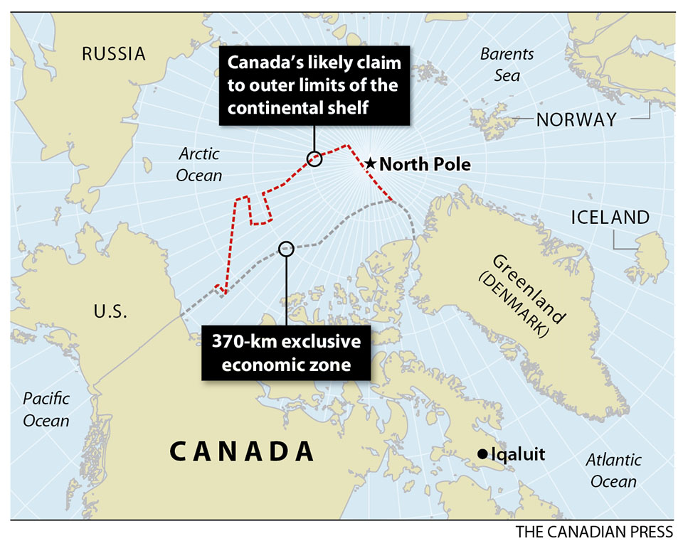
In official commentaries, senior People's Liberation Army (PLA) officers boasted their navy had "dismembered" the so-called first island chain - the arc of islands enclosing China's coastal waters, stretching from the Kuril Islands southward through the Japanese archipelago, Taiwan, the Northern Philippines and down to Borneo.

Named Manoeuvre 5, these were no ordinary exercises.
 They were the latest in a series of increasingly complex and powerful thrusts through the first island chain into the Pacific.
 For the first time in centuries, China is building a navy that can break out of its confined coastal waters to protect distant sea lanes and counter regional rivals.


Beijing's military strategists argue this naval punch is vital if China is to avoid being bottled up behind a barrier of U.S. allies, vulnerable to a repeat of the humiliation suffered at the hands of seafaring Europeans and Japanese through the colonial period.
"It tells Japan and the United States that they are not able to contain China within the first island chain," says Shen Dingli, a security expert and professor at Shanghai's Fudan University.
"So don't bet on their chances to do so at a time of crisis."

In the process, the rapidly expanding PLA navy (PLAN) is driving a seismic shift in Asia's military balance.
China, traditionally an inwardly focused continental power, is becoming a seagoing giant with a powerful navy to complement its huge ship-borne trade.
"As China grows, China's maritime power also grows," says Ren Xiao, director of the Centre for the Study of Chinese Foreign Policy at Fudan University and a former Chinese diplomat posted to Japan.
 "China's neighboring countries should be prepared and become accustomed to this."

China's strongly nationalistic Communist Party leader, Xi Jinping, has thrown his personal weight behind the maritime strategy.
 In a speech to the Politburo in the summer, Xi said the oceans would play an increasingly important role this century in China's economic development, according to accounts of his remarks published in the state-controlled media.
"We love peace and will remain on a path of peaceful development but that doesn't mean giving up our rights, especially involving the nation's core interests," he was quoted as saying by the official Xinhua News Agency.

Senkaku islands
Tensions increased furtherbetween Japan and China
over a disputed group of islands in the East China Sea.

BLUE WATER AMBITIONS

China is also making waves in the South China Sea, where it has territorial disputes with a number of littoral states.
But it is the pace and tempo of its deployments and exercises around Japan that provide the clearest evidence of Beijing's "blue water" ambitions.
Fleets of pale grey, PLA warships are a now a permanent presence near or passing through the Japanese islands.

An acrimonious standoff over a rocky jumble of disputed islands in the East China Sea, known as the Senkakus in Japan and Diaoyu in China, has given China an opportunity to flex its new maritime muscle.
Beijing has deployed paramilitary flotillas and surveillance aircraft to this zone for more than a year, where they jostle with Japanese counterparts.

Tension flared dangerously last week when China imposed a new air defense zone over the islands, demanding that foreign aircraft lodge flight plans with Beijing before entering this area.
In defiance of the zone on Tuesday, two unarmed U.S. B-52 bombers on a training mission flew over the islands without informing Beijing.
 The flight did not prompt a response from China.
"The policy announced by the Chinese over the weekend is unnecessarily inflammatory," White House spokesman Josh Earnest told reporters in California, where President Barack Obama is traveling.

 Japan rejects China’s claim to air rights over Islands

Washington and Tokyo immediately signaled they would ignore the restriction.
 The Obama administration also reminded China that the treaty obliging the United States to defend Japan if it came under attack also covered the disputed islands.
Particularly unnerving for Tokyo are the increasingly common transits of powerful Chinese naval squadrons through the narrowest straits of the Japanese archipelago, sometimes within sight of land.

This puts East Asia's two economic giants, both with potent navies, in direct military competition for the first time since the 1945 surrender of Japan's two million-strong invasion force in China.
 Drawing on a reservoir of bitterness over that earlier conflict, the demeanor of both sides signals this is a dangerous moment as U.S. naval dominance in Asia wanes.
 Even if both sides exercise restraint, the risk of an accidental clash or conflict is ever present.

"China and Japan have to come to terms with the fact that their militaries will operate in close proximity to each other," says James Holmes, a maritime strategist at the U.S. Naval War College in Newport, Rhode Island, and a former U.S. Navy surface warfare officer.
 "Geography compels them to do so."

What's at Stake for China and Japan in the Diaoyu Island Dispute? - Zooming In 

COORDINATED CROSSING

As the Manoeuvre 5 drills got under way, PLA Senior Colonel Du Wenlong said he was looking forward to units from the three regional Chinese fleets simultaneously crossing three key chokepoints - two through the Japanese islands, and one between Taiwan and the Philippines, according to reports in the official Chinese military media.
 It is unclear if the warships performed a coordinated transit.
 But the exercises and the response of the Japanese military contributed to a spike in tension.

"The PLAN has cut up the whole island chain into multiple sections so that the so-called island chains are no longer existent," Colonel Du was quoted as saying.

In this and earlier exercises, the PLA provided daily commentaries and details of the ships, courses and drills, with pointed mention of transit points past Japan.
PLA officers or military commentators, in typical communiqués, say China has "demolished" or "fragmented" the island chain in a "breakthrough" into the Pacific - language that suggests the crossings are somehow opposed rather than legal transits through international waters.

Tokyo dispatched warships and aircraft to track and monitor the Chinese fleet in response to the latest drills.
Japanese fighters also scrambled to meet Chinese bombers and patrol aircraft as they flew out to the exercises and back.
Japan's defense ministry later released surveillance photographs of a Chinese H6 bomber flying between Okinawa and Miyako Island on October 26.

All this attention clearly irritated the PLA leadership.
Beijing accused Japan of a "dangerous provocation" and lodged a formal diplomatic protest, complaining that a Japanese warship and aircraft disrupted a live fire exercise.

While the drills were under way, Japanese Prime Minister Shinzo Abe warned that his country would not be bullied.
"We will express our intention as a state not to tolerate a change in the status quo by force," he told a military audience on October 27."
"We must conduct all sorts of activities such as surveillance and intelligence for that purpose."

Naval commentators suggest the bellicose rhetoric shows that both sides are struggling to adjust to their new rivalry.
"Chinese hardliners do regional tranquility no service by talking about splitting Japan and so forth," says American naval strategist Holmes, co-author of an influential book on China's maritime rise, "Red Star Over the Pacific," with colleague Toshi Yoshihara.
"And, the Japanese do regional tranquility no service by being alarmed when China's navy transits international straits in a perfectly lawful manner."

Part of the problem for Japan is that it has been slow to adjust to China's rise, according to some Chinese foreign policy analysts, and is now excessively anxious.
"For so many years they looked down upon China which was big but weak," says Ren, the former Chinese diplomat.
"Now the situation is different and they have to face up to the new reality."

Some senior Japanese officers accept that China is within its rights to traverse international waters between the Japanese islands.
Likewise, they say, the Japanese are entitled to track and monitor these movements and exercises.

"The Japanese Self Defense Force's reaction is also in full compliance with international laws, regulations and customs," says retired Vice Admiral Yoji Koda, a former top Japanese naval commander.
Koda adds that the Japanese military routinely monitors Russian naval operations around Japan without friction or protest.

China looks to redraw Asian airspace

RISE OF SEAFARING POWERS

The ideological keel of Beijing's modern bid to become a maritime power was laid down as China's economic revival in the early 1980s flowed through into sharply increased military budgets.
The starting point for China's leading maritime thinkers is the trauma of European and Japanese colonization.

"The Qing Dynasty was badly defeated in naval warfare by overseas imperialist powers, leading to the decline and fall of the dynasty," wrote Zhang Wenmu, a professor at Beijing University of Aeronautics and Astronautics, in a 2010 article published in China's official state media.

Another premier Chinese maritime strategist is Ni Lexiong, a professor at Shanghai's University of Political Science and Law.
He has documented how China's failure to properly fund its navy was a factor in its 1895 defeat in the first Sino-Japanese war and the subsequent loss of Taiwan.

Zhang and Ni are regarded as China's leading advocates of the theories of the American naval officer, strategist and historian Alfred Thayer Mahan.
Both subscribe to one of Mahan's principal ideas: A truly powerful nation must have thriving international trade, a merchant fleet to carry these goods and a strong navy to protect its sea lanes.
Mahan's works, considered visionary in the late 19th and early 20th centuries, are still avidly read and absorbed in Chinese naval schools, Chinese military analysts say.

The rise of earlier seafaring and trading powers - Portugal, Spain, Holland, Great Britain, the United States and Japan - have also provided important lessons for strategic thinkers.
The vision and influence of the late Admiral Liu Huaqing, known as the father of the modern Chinese navy, also remains strong.

Liu, who died in 2011, rose to become overall commander of the PLA and a member of the Communist Party's Politburo standing committee, the country's supreme ruling body.
While Liu was head of the navy in the 1980s, it was an obsolete, coastal fleet.
But Liu was determined that China needed a blue-water fleet and aircraft carriers if it was to match the power of the United States and its allies.

Fundamental to the thinking of many Chinese strategists and military and political leaders is the conviction that China would be foolish to rely on the United States to protect its shipping.
They acknowledge that the U.S. Navy has guaranteed freedom of navigation since the end of World War Two, underwriting an explosion in global trade to the benefit of most other countries, including China.

The figures bear this out.
China last year overtook the United States as the world's biggest trader, according to official data from both countries.
Up to 90 percent of Chinese trade is carried by sea, including most of its vital imports of energy and raw materials, shipping experts estimate.
But Beijing's strategists fear the U.S. could interrupt this trade at a time of crisis or conflict.

Almost all of China's naval thinkers also agree that recovering Taiwan is crucial to realizing the dream of maritime power.
Restoring "national unity" is a longstanding goal of the ruling Communist Party.
But the self-governing island itself has immense strategic value, sitting astride sea lanes that are also vital for Japan and South Korea.

Control of Taiwan would open a huge breach in the first island chain around China.
PLA warships and aircraft based on the island could extend China's military reach far into the Pacific and much closer to Japan, without the need to first pass through potential choke points or channels in the chain.

"Taiwan is a part of the first island chain," says Fudan University's Shen.
 "Instead of being integrated into mainland China, it has been used as a part of the U.S. first island chain strategy."

ABANDONING THE MAOIST STRATEGY

China's turn to the sea has boosted the status of the navy, long the poor relation of the armed forces.
 The PLA, traditionally a massive ground force, was built around the Maoist strategy of drawing an invading enemy deep into the hinterland, where it could be destroyed through attrition.

Military strategists say this was thinkable before the country industrialized.
 Now that the eastern seaboard is the throbbing engine of the world's second-ranked economy, fighting a war here would be catastrophic for China, win or lose, they say.
 Far better to meet challenges at sea or on the territory of a hostile nation.

The late Admiral Liu is credited with sharply increasing the navy's share of the defense budget, outlays that have paid for a rapidly expanding fleet.
 In its annual assessment of the Chinese military published earlier this year, the Pentagon said the Chinese navy, now the biggest in Asia, deployed 79 major surface warships and more than 55 submarines, among other vessels.
 And the PLAN last year commissioned its first aircraft carrier.

Wu Shengli, the powerful admiral who now leads this force, is widely regarded as the most influential naval officer since Admiral Liu.
 Wu is also a member of the Central Military Commission, China's top military council.

PLAN warships are now highly visible in all major oceans, with an active schedule of ship visits to foreign ports.
 The Chinese navy is part of the international anti-piracy force in the Gulf of Aden.
 These deployments are heavily publicized in the state-controlled media as the navy becomes a symbol of China's growing international prestige.

This openness also applies to combat exercises.
The U.S. and other major powers routinely chastise China for a lack of transparency surrounding its three-decade military build-up.
 But it is difficult to accuse Beijing of secrecy when it comes to recent naval operations near Japan.
 The state-run media and a stable of specialist military newspapers, journals, web-sites and television channels devote blanket coverage to the deployment of warships, submarines, aircraft and patrol vessels on missions near China's neighbor.

Some military commentators say Japan shouldn't overreact to these messages, as they are primarily aimed at a domestic Chinese audience.

"The PLAN is a relatively young organization building up their capabilities and certainly not the ‘senior service' in China," says Alessio Patalano, a specialist on the Japanese military at King's College in London.
 "It's important for its leadership and its members to establish their credentials and increase their profile."

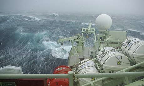
For exercise Manoeuvre 5, the Chinese navy followed the U.S. practice of embedding journalists.
Regular television reports from the Type-052 guided missile destroyer Guangzhou showed the 6,500 ton warship ploughing through heavy seas on route to the exercises.
Officers and sailors were interviewed at battle stations while they tracked targets and prepared missile launches.

Tokyo is keeping careful score.
In its latest Defense White Paper, published in July, the Japanese military charted steadily expanding PLA deployments near Japan since 2008, documenting bigger visiting fleets, more powerful warships and increasingly complex exercises involving helicopters, support vessels and land-based aircraft.

"Map of Tokara Islands and Senkaku Islands", issued in Japan, 1933.

ENCIRCLEMENT

After decades confined to its coastal seas, the PLAN began regular voyages from the East China Sea into the Pacific early last decade.
At first, Chinese warships mostly used the wide Miyako Strait between Okinawa and Miyako Island, according to statements from the Chinese and Japanese militaries.
Since then, in a series of firsts, they have transited all the other important channels between the Japanese islands, according to Japan's White Paper.
Then came encirclement.
In July, five PLA warships steamed out of the Sea of Japan through the Soya Strait, known as the La Perouse Strait in Russia, which divides the Russian island of Sakhalin and Hokkaido.
The Chinese fleet continued on around the Japanese islands and back to China.
"The move marks the first trip by the Chinese navy circumnavigating the Japanese archipelago," said a report on China's official military website.

Some Chinese strategists reject fears that deploying a powerful navy increases the odds of conflict.
"I am more confident than many outside observers that China will behave out of the nation's fundamental interests, namely, to take a path of peaceful development," says Ren.
"There is no reason to change this option."

For Japan, there might even be an upside.
Chinese warships used to be mostly confined to home waters, and thus hidden.
Now, they can now be monitored.
"The more exercises the PLAN conducts on the high seas around Japan, the better for the JMSDF to judge and collect the PLAN's warfare capabilities and intents," says Koda, the retired Japanese admiral.
 "The PLAN cannot intimidate Japan by these types of exercises."

Links :

Sunday, December 1, 2013

The rider and the storm


Timmy Brennan is a New York iron worker who escapes the grind of the city through his true passion, surfing.
But when Superstorm Sandy destroys his home in Breezy Point, Timmy loses everything — including his board.
As Timmy digs through the ruins of his home day after day, trying to recover lost possessions, he discovers the kindness of strangers and finds solace once again on the ocean.