Saturday, July 23, 2022

Ocean currents around Antarctica

 
from Nikolay Koldunov @oceanographer / image
 
One year in life of ocean eddies.
This is 3km resolution Southern Ocean setup of  @AWI_Media FESOM model. HR video

Friday, July 22, 2022

High-tech seafloor mapping is finding surprising structures everywhere

REEF TOWER
SOUTH PACIFIC, 50 MILES EAST OF CAPE YORK PENINSULA, AUSTRALIA
Scientists at James Cook University in Australia were charting underwater habitats just beyond the northern end of the Great Barrier Reef using multibeam sonar when they came on a freestanding coral reef tower 1,640 feet tall—taller than the Empire State Building.
The base of the wedge, shaped like a shark fin, is almost a mile across, and the tip is only 130 feet below the sea surface.
Subsequent dives by a remotely operated vehicle showed the tower was teeming with fish and exhibited no signs of the coral bleaching that has tormented the Great Barrier Reef.
Credit: Maceij Frolow

From Scientific American by Mark Fischetti

Giant coral towers, vast reefs and other formations are captivating explorers

Oceanographers are fond of saying that we know more about the moon's surface than we do about Earth's seafloor.
It's true.
As of 2017, only 6 percent of the global seabed had been mapped, typically by ships with sonar instruments sailing back and forth in straight lines across a local section of sea.

MILLION MOUNDS CORAL PROVINCE
NORTH ATLANTIC, 100 MILES EAST OF GEORGIA, U.S.
Investigators at the National Oceanic and Atmospheric Administration have finished mapping the “million mounds” deep-sea province.
Thousands of coral mounds, each 30 to 300 feet high, blanket 11,000 square miles of ocean floor, making it the largest deep-sea coral ecosystem ever discovered.
At a depth of 2,000 to 2,600 feet, the seafloor receives no sunlight, so the white corals don’t house symbiotic algae that give shallow reefs their color.
When old corals in the mounds die, their skeletons provide the foundation for new corals; some mounds have been growing for thousands of years.
Credit: Maceij Frolow

But since then, nations have become eager to chart the seafloor within their own “exclusive economic zones,” which reach 200 nautical miles from their shores, in part to look for critical minerals they can scrape up using big mining machines.
The other push is Seabed 2030—an effort to map Earth's entire seafloor by 2030, run jointly by the Nippon Foundation and the nonprofit General Bathymetric Chart of the Oceans.

RYDER GLACIER SILL
​​​​Geologists at Stockholm University were puzzled about why the front edge of Ryder Glacier, at the Sherard Osborn Fjord, was losing less ice than the faces of other Greenland glaciers.
Using multibeam sonar on an icebreaker in the fjord, they discovered two parallel sills of bedrock (red), separated by a basin, that cross the fjord.
The inner sill, about 3.8 miles across and 1,600 to 1,900 feet high, blocks relatively warm Atlantic Ocean water from reaching the glacier and melting its underside, slowing the glacier’s demise.
Credit: Maceij Frolow
 
Localization with the GeoGarage platfrom (DGA nautical raster chart)
 
The goal is to collect and stitch together mapping done by governments, industries and research institutions everywhere.
Public release of previously private bathymetric data is helping to widen the areas plotted.
And uncrewed, remotely operated vehicles fitted with sonar that can zoom around underwater for days at a time are speeding the pace of mapping.
By June 2022 an impressive 21 percent of the world's seafloor had been charted.
The more experts map, the more surprises they find—such as the three unexpected, unusual formations revealed here.

Links :

Thursday, July 21, 2022

What humans can learn from the sea cucumber’s toxic arsenal

While ordinary vegetable cucumbers cost $3 per kilo, sea cucumbers can cost over $3,000 per kilo. These animals are prized as a delicacy in Asia, and are used by pharmaceutical companies to treat diseases like cancer.
Unfortunately, over-harvesting now threatens many sea cucumber populations.

From Wired by Maggie Chen

Sea cucumbers are squishy and soft.
They also employ lethal strategies to protect themselves.

A SEA CUCUMBER, lying innocently on a bed of sand, looks kind of like a blob, and feels almost plushy.
But although the creatures seem squishy and defenseless, they have evolved fascinating strategies to keep themselves safe.
Anne Osbourn, a biologist at the John Innes Center in England, recently published a paper in Nature Chemical Biology that uncovered chemical compounds through which sea cucumbers protect themselves from attack—and themselves from being destroyed by their own poison.
Her team believes that understanding how to synthesize these valuable compounds can allow for the design and mass production of molecules that might be useful for human health.

Despite their unassuming demeanor, sea cucumbers are equipped with clever chemical tricks.
When threatened by predators, one of the strategies these animals can use is to expel their thread-like internal organs—known as Cuvierian tubules—through their anus.
These tubules immobilize the predator in a sticky, toxic embrace.
The toxicity comes from saponins: chemical compounds that are known for their antioxidant and anti-inflammatory properties.
Saponins are commonly found in plants as an antimicrobial defense mechanism, and they are used to fend off pathogens such as fungi.
Their antifungal activity comes from their ability to bind with cholesterol­—a key component of the cell membrane­—and poke holes in it, causing cell death.

But saponins are much less common in animals.
Having originally studied these compounds in plants, Osbourn was intrigued to find that they existed in sea cucumbers—specifically a variety of saponins that are built from terpenoids, organic ring-like scaffolds.
(These triterpenoid saponins differ chemically from other classes, due to the attachment of methyl groups at specific carbon positions. And, as Osbourn puts it, “They look a bit like chicken wire.”)

To figure out exactly which saponins the sea cucumber makes, the scientists extracted chemical compounds from stores of dried sea cucumber as well as from the tissues of live sea cucumbers (P.
parvimensis and A.
japonicus) at various stages of development.
Reconstituting a dried sea cucumber was relatively simple: “You just put one sea cucumber in a petri dish, put some water, come back a day later, and it becomes a real sea cucumber,” says coauthor Ramesha Thimmappa, formerly a postdoctoral scholar in Osbourn’s lab.
“It swells!”

Then, the scientists used liquid chromatography mass spectrometry, where individual compounds in the extracts are separated into charged particles and shot into a mass spectrometer.
The instrument measures the speed at which the particles travel to determine each one’s weight, which can then be used to identify each compound’s molecular composition.


They discovered several saponin compounds, some of which, Osbourn says, “tend to be in the outer walls of the sea cucumber: in the tentacles, the body wall, the feet. In the outer tissues, it’s the right place to provide protection.”
They found others that were primarily present in the early growth stages of the sea cucumbers.
“We think that they may protect the eggs against predators—fish and various other grazing creatures,” she says.

But this chemical defense creates a big problem for sea cucumbers: They need to avoid killing themselves with their own toxins.
And that means their own cells can’t contain cholesterol, the target that the saponins bind to and pierce.
Instead, they have evolved two kinds of cholesterol alternatives: lathosterol and 9(11) sterols, which probably fulfill the same function of maintaining cell membrane stability.
The scientists believe that the sea cucumbers’ ability to make saponins—and these saponin-resistant sterols—evolved concurrently.
“We think it’s a self-defense strategy,” Osbourn says.
“If you can produce these toxic compounds, you have to be able to not poison yourself.”

As it turns out, these unique evolutionary capabilities hinged upon a single point.
Sea cucumbers are part of the echinoderm family, along with sea stars and sea urchins.
They all share a common ancestor, but sea urchins don’t have the same saponin defense superpowers.
So to figure out how the sea cucumbers had diverged genetically from the rest of the group, Osbourn and Thimmappa (now an assistant professor of genome engineering at Amity University) compared their genomes to those of their echinoderm counterparts.
Specifically, the researchers were interested in studying lanosterol synthase, a highly evolutionarily conserved enzyme that is critical for sterol and saponin biosynthesis.
It folds their precursor molecules into intricate origami-like shapes.

The team discovered that sea cucumbers just don’t have it.
Instead, they have two enzymes that are from the same family but are drastically different in biological function: One gives rise to the saponins found in juvenile sea cucumbers, the other creates their cholesterol alternative and also generates saponins found in their outer walls.
One change from the traditional lanosterol synthase sequence in the amino acid chain was all it took to create these two sea cucumber-specific enzymes with completely different functions—an evolutionary adaptation that was “simple, but very elegant,” says Thimmappa.

This work of characterizing and determining the functions of single chemical compounds in sea cucumbers is “super cool,” says Leah Dann, a PhD student at the University of Queensland who studies island conservation and was unaffiliated with the study.
For sea cucumbers, which don’t have adaptive immunity (the ability to generate antibodies that can prevent future diseases), these saponins might help protect against harmful microbes or fungi.
And, since they don’t have a spiny outer shell, these chemical defenses may explain why many organisms leave them alone.
“They look so yummy,” Dann says.
“But most fish will not touch them.”
“They explained why sea cucumbers have triterpenoid saponins,” says Lina Sun, a professor at the Institute of Oceanology at the Chinese Academy of Sciences.
(Sun is unaffiliated with the study, and her comments have been translated from Chinese.) Discovering and characterizing the two synthase pathways that generate these saponins and special sterols is “very important,” she adds.
From this work, Sun is interested to see how, in other echinoderm species, the genes associated with saponin biosynthesis might differ from those in sea cucumbers.

A compound that attacks cholesterol has some intriguing implications for human health care.
“Sea cucumbers are highly valued both for food and for health,” Osbourn says.
“Sea cucumber extracts, which are rich in saponins, are very valuable.”

They have long been harvested as a culinary delicacy—and revered for their antioxidant and anti-inflammatory health benefits.
(The saponin dosage in certain sea cucumbers, while sometimes lethal for fish and other small critters, can be edible and even beneficial for humans.)
Studies have previously found that sea cucumber saponins can reduce cholesterol and inhibit inflammation to alleviate atherosclerotic plaques in mice, and have been connected with anti-tumor activity against cancer.

Saponins also have other uses for home and personal care, like for making soap.
Originally named after their presence in the roots of the soapwort plant (Saponaria), saponins can dissolve in water to create a frothy broth.
“Nature is so good at making chemicals,” Osbourn says admiringly.

In the future, she and her team are interested in learning how to synthesize more of these naturally derived compounds—to recreate them on a larger scale without having to harm any sea cucumbers, and to “harness all of the triterpene diversity that’s out there in nature.”
Ultimately, she thinks, such molecules could be designed and made on demand, to be used as medicines, or commercialized as foaming agents or emulsifiers.

In the meantime, though, one of the most likely places you’ll find sea cucumbers and their compounds is in soup—something Osbourn was once served for lunch when attending a conference in China.
“It was quite chewy,” she says.
“I’m sure it was good for me.”
 
Links :
 

Wednesday, July 20, 2022

How vulnerable Is the Mediterranean to tsunami risks?


A sign on the Tel Aviv beach informing of the tsunami risk.
Credit: Beverly Goodman-Tchernov

From Haaretz by Ruth Schuster

Over 2,500 years ago a Greek general identified the link between quakes and tsunamis, but how often have tsunamis plagued the Mediterranean?
An expert tells us how to identify mega-waves of the distant past – and the future risks

On Saturday evening, an underwater volcano in the South Pacific erupted.
As steam, volcanic ash and debris shot 20 kilometers (12 miles) into the air, the shock waves sent tsunamis spreading in all directions, first hitting the adjacent island nation of Tonga and later Hawaii, California, New Zealand and Japan.

The waves making landfall weren’t huge, but damage did ensue.
As of this writing, three possible casualties in Tonga had been reported, though not confirmed.

But actually any undersea eruption of noticeable magnitude is bound to unleash tsunami waves, says Prof. Beverly Goodman-Tchernov, head of the University of Haifa’s Marine Geosciences Department at the Charney School of Marine Sciences.

The question is what sort of tsunami waves.
Experts refer to two categories of sources: “near-field,” a nearby source such as a landslide, which tends to have a more localized effect, and “far-field” large events that occur offshore, which can affect a greater range of coastlines.
The Hunga-Tonga-Hunga-Ha’apai volcano was a far-field type.

We who live on the balmy Mediterranean Sea may feel we’re safe from the mega-quakes and tsunamis that have wreaked devastation in the Pacific, and more rarely in the Atlantic.
We are not.

The Mediterranean region is seismically frisky, boasts a few impressive volcanoes (even a super-volcano, Campi Flegrei) and has a history of tsunami action, not that there are clear records of the anomalous waves.
The fact is, most people in a position to closely observe a paleo-tsunami probably drowned, and the survivors wouldn’t necessarily have understood the context.

So what applies worldwide applies to the Mediterranean as well.
Undersea volcanism is only one of many potential causes of tsunamis, which are usually not a single event but a series of waves – in the ocean, a sea, even lakes.
And most dangerously for the likes of Tel Aviv, they spread inland via river valleys.
The most common cause that people have heard of is an underwater earthquake.
When a portion of seabed rises or falls in a quake, so does the water column above it.
The displaced water “wants” to spread.

As the waves advance from deep to shallower water and approach the shore, their volume and energy is preserved, thus they erode the seafloor, their speed slows and their height grows.
A tsunami mere centimeters high in the open ocean may be meters high when it hits the shore.
The highest tsunami in recorded history reached 524 meters (1,720 feet), dousing the Lituya Fjord in Alaska in 1958 after a quake.

That quake didn’t directly cause the tsunami at Lituya Bay.
What did was the ensuing landslide into the sea.
That calamity originated on land, but underwater landslides are a thing too and a key cause of tsunamis on the Israeli coast.

“The reality is that anything that causes significant-enough water displacement can result in a tsunami,” Goodman-Tchernov says.
“If sediment on a submerged slope builds up to a point that it fails, as that material moves, it pushes the water and displaces it – that can create quite large tsunamis.”

How large? Potentially enormous; a collapse along the Norwegian continental shelf 8,000 years ago is believed to have triggered a series of mega-tsunamis that washed over the Doggerland land bridge and rolled high onto the Paleolithic British coast.


The coast at the Israeli city of Caesarea, which "has been a tsunami magnet."
Credit: Beverly Goodman-Tchernov

Another potential cause is meteorite impact.
The asteroid that killed almost all the dinosaurs slammed into the Gulf of Mexico, setting off world-spanning mega-tsunamis as much as a mile high, scientists estimate.
The wave could have been higher if the meteorite had hit deep ocean rather than shallow sea.

One last cause is we.
“There have been man-made tsunamis – minor, but still – from testing bombs,” Goodman-Tchernov says.
At least we’ve never created one that’s been terribly damaging, she adds.
Well, the day is young.

Shaky in the Mediterranean ‘ocean’

Though it hasn’t suffered a mega-tsunami like those seen in the Indian Ocean or Japan in recent history, the Mediterranean has had, and will have, its share of these waves, including – it seems – one monster that’s believed to have hit Dor on the Israeli coast about 4,500 years ago.

“The Mediterranean has all of the hazards. People think of it as a quiet vacation destination, but the reality is, it has all the features of the large ocean, including the tectonic activity and deep basins.
It has the bathymetry [underwater topography] that includes the potential for landslides, and it even has a few volcanoes,” Goodman-Tchernov says, referring chiefly to Italy’s Etna and Thera on Santorini island in the Aegean.
“Meteorite impacts are, of course, equal opportunity worldwide, including the Mediterranean.”

Historical records of tsunamis are rare and oblique, but what else could the Athenian general and historian Thucydides have been talking about in his “History of the Peleponnesian War” written 2,500 years ago?
The Peloponnesians and their allies invaded but were deterred by earthquakes, he wrote.

As Thucydides put it, “About the same time (Euboea being then troubled with earthquakes), the sea came in at Orobiae on the part which then was land and, being impetuous withal, overflowed most part of the city, whereof part it covered and part it washed down and made lower in the return so that it is now sea which before was land.
And the people, as many as could not prevent it by running up into the higher ground, perished.” (Translated by Thomas Hobbes in 1843.)

Thucydides then described similar events in Atalanta and Peparethus.
The historian may have been among the first to deduce the underlying trigger: “And it seemeth unto me that without an earthquake such an accident could never happen”

Goodman-Tchernov notes that a terrestrial quake may trigger not only landslides on land and at sea, but also a sequence of quakes along the same system.

Caesarea, tsunami magnet


An expert on identifying paleo-tsunamis, Goodman-Tchernov has done a great deal of work in Caesarea, a port city on the Mediterranean that goes back more than two thousand years and flourished in the Roman, Islamic and Crusader periods.
There she has spent over 20 years recording and analyzing deposits both on land and in the sea with the Israel Antiquities Authority and other partners, identifying both historically noted tsunamis as well as ones without any known written record.

Absent historical records either because there were no witnesses or because the observers died, fled or were illiterate, records did not survive, or the witnesses couldn’t write in the first place.
Thus the discovery of physical remains is the only recourse.


Students doing tsunami research in the lab.
Credit: Beverly Goodman-Tchernov


Identifying such prehistoric or later unrecorded tsunamis relies on identifying anomalous sediment layers, debris and destruction with the hallmarks of tsunami inundation; for example, seashells a couple of kilometers inland.
Identifying paleo-tsunamis relies on basic sedimentology.

“We look at what is deposited on the landscape and try to reconstruct what its source was,” Goodman-Tchernov explains.
Researchers compare with bona fide tsunami deposits, going through an exhaustive elimination process regarding what could have caused anomalous deposits; for instance, agglomerations that seem to have elements of land, sea, river, garbage and debris.
“We’re not proving anything; we’re disproving every other possibility.”

Her work has led her to the observation that near-field tsunamis can have quite localized impacts; you might find evidence of an ancient inundation along the shore in one place but not in nearby sites.

“Caesarea has been a tsunami magnet.
It’s unusual,” she says, though immediately qualifies for the benefit of the city’s residents that this could be due to sampling bias; that is, that’s where the researchers have been looking.
Or it could be that Caesarea really is in the sweet spot for more than one of the offshore slumps along the coast.

Why might the impact of a landside-triggered tsunami be lesser than, say, the Tongo volcano blowing underwater?
The models suggest that a slump pushes water away from it outward; the least-impacted places seem to be immediately in front of where the slide happened, Goodman-Tchernov notes.
When you have an undersea earthquake or eruption, the shock spreads as concentric circles from a single point.

So there are slumps off Israel’s coast – at Palmahim, the Dor disturbance – offshore mapping shows where there have been past sediment failures.
And it’s possible that these cause the tsunamis at Caesarea.

“The bottom line is that there are different sources. Some will affect a larger part of the Mediterranean – which doesn’t mean the waves are bigger, necessarily. They may be bigger in the distribution of the effect but not necessarily in terms of the impact on each coastline,” she says.

“Take the far-field 1956 quake along the Hellenic arc near Crete that caused very large tsunamis nearby.
Crete was hit by waves some 10 meters high or more. The waves reached the Israeli coast too but had petered out; the only evidence for it was a perturbance recorded on tidal gauges. The normal pattern changed. But it didn’t cause any local damage that we know of.”

Tsunami-tinted glasses


Whether a tsunami roaring toward Israel was caused by earthquakes near Greece or Turkey, or an offshore slump near Caesarea, what matters to us is how much warning time we have.

Can they be predicted? Nope, not until a triggering event has occurred.
Not that there is such thing as estimating how frequent tsunamis can be anywhere.

“When talking about frequency in the Mediterranean, we hear a lot of people throwing out a value of a significant tsunami around every 600 years. This number is a little bit misleading,” Goodman-Tchernov puts it courteously, then proceeds to rubbish the theory.

“It presumes that, one, we know about all the tsunamis, and, two, it gives us the false impression that these things occur in some kind of consistent pattern, which is absolutely untrue. An average of 600 years means nothing. In fact, what I’m seeing through my research is that the variation in the gaps between events are extreme.”


Goodman-Tchernov at work on the coast.
Credit: Evi Nominkou


In some cases, she sees evidence for tsunamis so close in time that they may actually have been from the same triggering event, or within a year of each other.
Or nothing for a thousand years.
Caesarea, for example, seems to have had quiet for 1,600 years; there is no evidence of a tsunami in that time.

So does that mean one is overdue? Again: No.
Could be.
We don’t know, and Tel Avivians, snigger not.
We’re at special risk because if and when, displaced seawater could come roaring up the Yarkon River where it feeds into the sea.
So averages and suchlike don’t help us whatsoever.

“As people we love to have averages, but it’s really artificial. We do it all the time, talking of 50-year storms, but these numbers are relevant mainly to insurance companies, not the natural world,” Goodman-Tchernov says.
Indeed, in this era of climate change, such figures are rendered more irrelevant than ever before.

Could global warming and ocean warming affect the tsunami risk? Apparently not; finally something isn’t a function of climate change.

But doesn’t it seem, just as our planet is warming, that tsunamis are on the rise?
They are not – not necessarily – the professor reassures us.
It’s just that after the horrendous Indonesian tsunamis of 2004, more attention – including by the Israeli government – is being paid to the phenomenon.
People are wearing tsunami-tinted glasses, Goodman-Tchernov laughs.

But as sea levels rise, and they are, more and more communities are at risk with the commensurate potential for property damage and loss of life.
And if you’re in Tel Aviv, don’t snort at the “tsunami evacuation route” signs.
You may think you’re running madly for higher ground, but actually you’ll be racing full speed toward the Yarkon River Valley.
 
Links :

Tuesday, July 19, 2022

Rising seas are the next crisis for the world’s ports


The port of Los Angeles and Long Beach, October 2021.
Photographer: PATRICK T. FALLON/AFP

From Bloomberg by Francis Wilkinson


The delicate choreography of ships, trains and trucks at the world’s ports has been badly disrupted by the pandemic, and the turmoil is not likely to end soon.
If a virus can have such an adverse impact on the journey of a plastic toy or automobile from Point A to Point B, consider the potential impact of something even more pervasive and powerful: water.

In the years ahead, sea level rise, more intense storm surge and jacked-up tropical storms will be visiting many of the world’s roughly 3,800 ports.
Most of those ports are coastal; roughly a third are located in a tropical band vulnerable to the most powerful effects of climate change.
“If sea levels rise and storms become stronger as expected in the future due to climate change, the magnitude and costs of these disruptions are expected to grow,” states a report from the Environmental Defense Fund.

Ports cannot easily escape the influence of water.
When extreme rains led to flooding in Itajai, Brazil, in 2017, the floodwaters produced currents strong enough to prevent ships from berthing.
The port was closed for three weeks.
Just as too much water poses a threat, so too does not enough.
Extended drought along Germany’s River Rhine in 2018 lowered the water table and made it impossible for some ships to pass.

“Ports, working waterfronts and coastal infrastructure more generally have a lot of pressures on them from a number of sides,” said Austin Becker, chair of the department of marine affairs at the University of Rhode Island.
“They’re located in highly sensitive environments that are often in estuaries where riverine systems meet the ocean. They’re there because that was a nice way to get cargo from one country to another, and then get it inland through a riverine system.”

Because ports were early tenants of waterfront cities, there is no place to which they can easily retreat from rising seas.
As Becker told me, cities grew up around the ports.
And then the cities pushed the ports further toward the sea.

As cities have enveloped ports, so have the transportation networks that enable goods to travel from the sea inland.
“They need all these other infrastructure connections that have grown around them over the years — rail systems and highway systems and pipelines and that kind of thing,” Becker said.
In most prosperous, or even middling, cities, the land necessary for such systems is long spoken for.
As a result, most train tracks, roadways, warehouses and other infrastructure adjacent to ports will not be moved to higher ground away from the water; they will have to be adapted to manage the rising threat.

Port infrastructure is constantly evolving, noted Philip Orton, a professor of ocean engineering at Stevens Institute of Technology.
Ports are accustomed to incorporating new technologies — and the biggest ports, which have had to evolve to handle the needs of enormous, 1,300-foot-long container ships, tend to be the most flexible.
But the loading and transit areas behind ports are generally less innovative and less resilient.
When storm surge from Hurricane Marie hit Southern California in August 2014, damage to the Port of Long Beach caused shipping operations to halt for several days.
But as a subsequent report noted, it was months before the surrounding roads and facilities were back to normal.

The seas have been rising incrementally for centuries, but the projected rise in this century is markedly different, as are the consequences.
The basic formula is this: Greenhouse gas emissions produce higher temperatures.
Those higher temperatures warm the water, expanding the volume of the seas.
As temperatures rise, ice stored at the poles and elsewhere — including mountain glaciers — melts, further increasing water volume.
It is a powerful feedback loop that will cause the rate of sea rise to increase dramatically as the 21st century progresses.

More than 200 feet of potential global sea rise is currently stored in ice.
According to the United Nations Conference on Trade and Development, the world’s glaciers will lose between 18% and 36% of their ice mass this century.
Meanwhile, the Greenland and Antarctic ice sheets are melting at a faster pace than previously expected.

Millions of years ago, before those ice sheets materialized, water covered far more of the earth than it does now.
The northern rim of the Gulf of Mexico, for example, was not along the beaches of what we now call Alabama and Mississippi.
It was in present-day Illinois.
The Gulf will not be flooding Chicago anytime soon.
But at sea level, one foot of vertical rise can produce about 100 feet of horizontal spread.
In many low places, that translates to a lot of flooding.

Sea level rise will not be consistent across the globe.
But according to US government projections, if the world significantly reduces greenhouse gas emissions, there may be about two feet of rise by 2100.
If it doesn’t, the National Oceanic and Atmospheric Administration notes, average sea level rise for the contiguous US could be more than seven feet.
Ports, like other coastal real estate and infrastructure, are very much in the flood zone.

A paper by a team of researchers at Princeton and Rutgers points to a “preparedness dilemma” in the US.
“While the federal government seeks to protect citizens from natural disasters, it has limited control over efforts to do so,” the researchers write.
“Both the exposure and vulnerability to a coastal hazard are largely shaped by state and local land use and building codes.”

One thing that helps to galvanize political and financial support for resilience upgrades, they say, is a whopping storm:

In one model of the policy process, floods, hurricanes, and other extreme weather events have been viewed as “focusing events,” whereby they refocus the attention of elected officials and publics on an existing problem.
During a focusing event, a “policy window” of opportunity opens for a short period, and advocates emerge, racing to push their preferred solutions through before the window closes.

For the Port Authority of New York and New Jersey, Hurricane Sandy in 2012 was a focusing event.
Sandy shut down most of the port for a week, which resulted in 25,000 shipping containers being diverted to other ports.
Waterways had to be surveyed and cleared.
Some cargo terminals and maritime support facilities were out of commission longer, due to power failures and damaged equipment.
Oil terminals, for example, couldn’t offload product from tankers because they lacked power.
Damages to port authority operations, which include commuter rail, reached an astonishing $2.2 billion.

The Port Authority’s resilience and sustainability efforts after the storm included complex analysis of the port’s future but also some very basic problem solving.
For example, engineers realized that motors for container cranes can be raised higher off the ground to avoid being inundated.

For the most part, cranes, like electrical substations and other vital infrastructure, are not owned by the Port Authority.
So upgrading — which often means elevating — requires coordinated action with various private partners.
Mitigation efforts at U.S. ports, said Austin Becker, will require disparate interests coming together.

Given the central role that ports play in global commerce, however, those interests include more than those of shipping companies and others directly engaged in port activities.
All kinds of businesses and consumers, including the most landlocked, depend on ports.
Yet not all of those ports will prove dependable in the face of the 21st century’s rising waters.
“Thousands of small and medium ports that provide these really essential services to their local economies and local regions don’t have the resources they need and are already working with outdated infrastructure,” Becker said.

Giants such as Long Beach and the Port of New York and New Jersey have the financial power and expertise to ride out the rising seas.
As the water rises, however, hundreds of smaller ports are left hoping their luck doesn’t collide with the next waterborne “focusing event.”
 
Links :

Monday, July 18, 2022

Nicaragua v. Colombia: World Court orders sea map adjustments


Modified by PolGeoNow from map included in public court documents
(original created by International Mapping).
 

Modified by PolGeoNow from map included in public court documents (original created by International Mapping).
 
EEZ with the GeoGarage platform
 
Latest World Court Ruling: Nicaragua v. Colombia Sea Dispute

Judgments handed down by the UN's International Court of Justice (ICJ) - also known by semi-official nickname "the World Court" - can be pretty interesting to political geography nerds like us.
Often they establish new land and sea borders or end long-running territorial disputes, as you might have seen in our past coverage of the  
and Somalia v. Kenya cases.

On the other hand, there are plenty of ICJ cases that have nothing to do with drawing lines on a map, and you could be excused for assuming that the Nicaragua v. Colombia judgment from this past April was one of those.
After all, it was mainly about Nicaragua's accusations that Colombia simply wasn't respecting a sea border already drawn by the court in 2012, which theoretically ended a dispute around several Colombia-claimed islands in the Caribbean Sea near Nicaragua.
 
But as it turns out, there actually were some map-changing outcomes from the April judgment: Besides deciding that Colombia had indeed acted illegally in Nicaraguan waters in several cases and had to stop, the court also ruled on some territory-related claims by both Colombia and Nicaragua, establishing the legal status of lines on the map that had previously been disputed.
 
Colombia's "Integral Contiguous Zone"

The first topic of interest in the judgment is Colombia's "Integral Contiguous Zone", which it claimed gave it the rights to conduct various law enforcement maneuvers around and between its Caribbean islands, even on Nicaragua's side of the border the court drew in 2012.
Colombia seems to have invented the term "Integral Contiguous Zone", though a normal "contiguous zone" was already a thing in international law:

The UN Convention on the Law of the Sea (UNCLOS) establishes that beyond a country's "territorial sea" - a strip of water up to 12 nautical miles (NM) wide that counts as fully part of the country - there can also be a "contiguous zone" where the country can run "customs, fiscal, immigration or sanitary" law enforcement operations (though it can only do that in cases that are relevant to violations within the 12-mile territorial sea).

Nicaragua came to the court complaining that Colombia's contiguous zone was set up illegally,* and the judges ended up agreeing, on two different counts:

First, the UNCLOS states that the contiguous zone can't go more than 24 NM beyond the country's "baselines" (basically its coast, but see later in this article).
And instead of just defining lines 24 miles from each one of its islands, Colombia had gone farther and drawn one big outline to contain all those 24-mile circles and the gaps between them (this is apparently what it meant by "integral").
The result was that, in the larger gaps between islands, Colombia claimed waters as part of its contiguous zone that weren't actually within 24 NM of any land.


Modified by PolGeoNow from map included in public court documents and created by International Mapping.
 
Second, the Colombian law establishing the contiguous zone asserted that patrols could use the zone to protect Colombia's "security", including actions against drug smuggling, piracy, and environmental damage.
However reasonable that might sound, the court couldn't find any basis in international law to allow those uses of the contiguous zone, except when related to enforcing customs and immigration rules for boats headed to or from the islands or their territorial seas.

More importantly, the power to enforce environmental protection laws is specifically a feature not of contiguous zones, but of "exclusive economic zones" (EEZs), which stretch from the territorial sea out to as much as 200 NM from a country's coastline.
This wasn't really an issue where Colombia's contiguous zone overlapped with its own EEZ, but the thing was, big parts actually overlapped with Nicaragua's EEZ instead.

The court did make clear that there was no reason, in principle, that one country's contiguous zone can't overlap with another country's EEZ.
But that crucially depends on the assumption that the contiguous zone and the EEZ each involve separate and mutually-exclusive powers - one country's customs checks on boats about to enter its territorial waters doesn't have to interfere with another country's right to regulate environmental protection, fishing, or oil drilling at the same location.

So in the end, the court came to these three conclusions: Colombia's "Integral Contiguous Zone" isn't legally valid anywhere that isn't within 24 NM of land
Colombia can't claim environmental protection or other "security" powers within its contiguous zone (with some exceptions in areas that are also part of its EEZ)

Colombia has to change its law to avoid claiming either the contiguous zone in the gaps beyond 24 NM or the extended powers anywhere they overlap with Nicaragua's EEZ

What about the parts of the "Integral Contiguous Zone" beyond 24 NM but within Colombia's own EEZ? The court did making a binding ruling that they were legally invalid, but didn't demand that Colombia do anything about it.
Since the case had been brought by Nicaragua, the judges said they only had the power to give orders where Nicaragua's own rights were being directly violated.

*Colombia technically isn't directly bound by the UNCLOS, since its legislature never "ratified" the treaty (incorporated it into Colombian law).
But its government agrees that it's still accountable to "customary international law" - the standard principles in practice by the world's countries - and in this situation those principles are considered to be based closely on the UNCLOS.
 
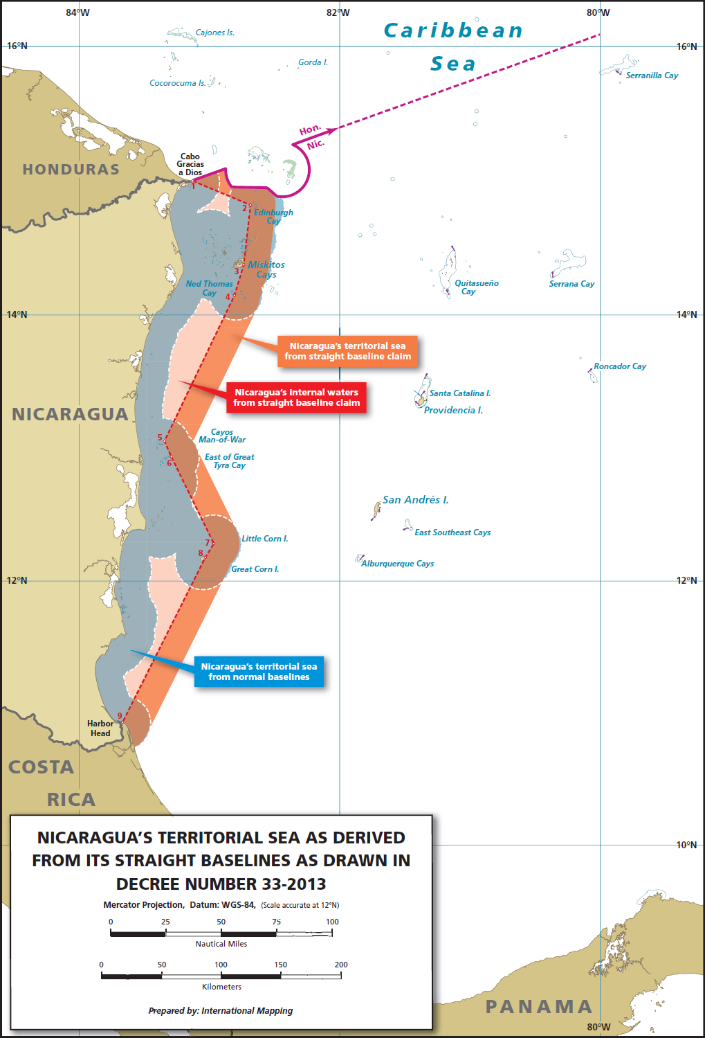
Map of Nicaragua's territorial sea and internal waters with and without straight baselines.
Graphic from public court documents, created by International Mapping.
See below for map with the two versions side-by-side instead of overlapping.
 
Nicaragua's Straight Baselines

Though the case was brought against Colombia by Nicaragua, that didn't stop Colombia from hitting back at what it said were Nicaragua's own violations of the Law of the Sea.
In particular, Nicaragua uses something called "straight baselines" to define the starting point that its 12-mile territorial sea and 200-mile EEZ are measured from.
Instead of measuring directly from its coastline, it draws a straight line connecting the dots between a bunch of different small islands just off the coast, and measures starting from there.

The result is that Nicaragua's claimed territorial sea, and potentially the EEZ, both stretch farther out into the ocean in some places than if it had measured them directly from the coast.*
*The effect of straight baselines on the EEZ is more subtle and less consistent than their effect on the territorial sea - at 200 NM out, one or another of the coastal islands themselves is often just as close as any part of the straight baseline.
Not only that, but Nicaragua can also then claim a sizeable strip of sea between the islands and the mainland as "internal waters", where exceptions to a country's territorial sea powers - like a requirement to let foreign ships transit through - don't apply.

This "straight baselines" method might sound awfully similar to the principle behind Colombia's "Integral Contiguous Zone", and in a way is.
But the difference is that straight baselines are well-established as legitimate according to the Law of the Sea - in certain cases.
The idea is that countries whose coastlines are almost closed off by rows of nearby islands shouldn't have to treat the in-between waters any differently than they would treat a harbor or a lake.
And if the islands really enclose the coast, drawing straight baselines doesn't make much difference in how far out the territorial sea or EEZ stretch anyway, because without them the 12 NM and 200 NM would still be measured from the coasts of those islands.

The problem, according to Colombia, was that it's really a stretch to say Nicaragua's Caribbean coastline is enclosed by a row of islands - that it's more like some clusters of islands here and there.
And the court ended up agreeing that the straight baselines were invalid, despite Nicaragua claiming that they were justified by parts of the ICJ's own 2012 judgement.
Not only that, but the judges said Nicaragua failed to prove that all the dots it was connecting were even legally real islands, as opposed to reefs that only stick out of water at low tide.
The result was that large chunks of ocean between the islands had been claimed as Nicaraguan internal waters despite being wide open to the outer sea, and large chunks of ocean beyond them claimed as Nicaraguan territorial waters despite being more than 12 NM from any land.

Since, again, this was specifically a court case brought by Nicaragua against Colombia, the judges didn't feel they had the power to demand that Nicaragua change its law and withdraw the straight baseline claim.
But they did rule that Nicaragua's specific straight baseline claim wasn't legally valid, implying that another country (such as Colombia), would immediately be justified if its ships ignore Nicaraguan claims to those extra territorial seas and internal waters.
(In fact, Costa Rica and the US have also both disputed Nicaragua's use of straight baselines.)
 
 
Will Colombia and Nicaragua Accept the ICJ's Judgment?

The short answer is "Apparently, yes".
The International Court of Justice insists that its judgments are legally binding, though it can be difficult to enforce them if a country's government resists, as Kenya has done since the judgment on its sea border dispute with Somalia last year.
In theory, the UN Security Council could authorize sanctions or even a military intervention to force compliance, but in most cases the countries' governments comply on their own, either voluntarily or based on orders from their own courts, with the Security Council rarely getting involved either way.

And it looks like Nicaragua and Colombia have both more or less accepted this ruling.
The Nicaraguan government, for its part, has enthusiastically welcomed the judgment as a whole, even promising to revise its baselines law to comply with the court's findings, despite the court not having directly ordered it to do that.
Colombia's government has taken a different route, playing down the results of the case by spinning the overall judgment as a victory and barely mentioning the rulings against it.

Specifically, in press statements, Colombia's representatives mostly emphasized a list of thingsthe court didn't tell Colombia not to do (some of which, based on our non-expert reading of the court documents, still sound like quite a stretch).
But a Colombian newspaper article based on those statements still acknowledges that the government "will have to adjust" the contiguous zone, while in another report a Colombian representative said that a "special procedure" would be needed to implement the changes - seeming to imply that the government at least accepts its obligations in principle.

Meanwhile, when Nicaraguan leader Daniel Ortega publicly accused Colombia of refusing to recognize the judgment, Colombia's president didn't directly address the issue, but dismissed Ortega's claims as the words of a "post-truth" dictator.

But didn't Colombia reject the ICJ's jurisdiction in 2012?

On November 27, 2012, the week after the ICJ's first judgment setting the boundary between Nicaraguan and Colombian waters, Colombia's government moved to reject the court's ability to make judgments affecting the country.
To do this, it announced it was withdrawing from the Pact of Bogotá, a treaty named after Colombia's own capital city, which made it clear that the ICJ had the authority to resolve disputes between most countries of the Americas.

That might make it sound like Colombia was refusing to accept the the 2012 judgment, but its government has stressed that its withdrawal from the pact wasn't retroactive, and only applied to future international lawsuits, meaning that it still had to accept the results of that judgment.
And in fact, since the Pact of Bogotá specified that it takes a country one year to withdraw from it, Colombia was officially still part of the treaty until November 27, 2013.

The second ICJ case between Nicaragua and Colombia - the subject of this article - was first filed by Nicaragua on November 26, 2013 - the last full day before Colombia officially left the treaty.
Though Colombia tried at first to argue that new ICJ cases couldn't be submitted against it during that one-year waiting period, the 16 judges of the court voted unanimously in 2016 to reject that argument, concluding that Colombia was stretching its interpretation of the rules too far and Nicaragua had gotten its application in just in time.

Colombia's Non-Implementation of the 2012 ICJ Judgment

Though Colombia's government has accepted the authority of the World Court in principle for both the 2012 and 2022 judgments, it's also insisted that it can't actually change its own laws about where its borders lie (including where its EEZ and contiguous zone extend to).
Colombia's constitution says the only way to change the country's borders is through a treaty, and the Colombian constitutional court confirmed in a 2014 ruling that the government was correct in interpreting that rule to mean it couldn't fully and immediately comply with the 2012 judgment.

Back to the present, when Colombia's representative says the ICJ's new order to change the contiguous zone law can't be implemented without a "special procedure", he's presumably talking about that same constitutional hangup.
Based on Colombian law, the "procedure" to implement the court order would apparently have to be either a new treaty (for example, one signed with Nicaragua) or an amendment to the constitution.
So in reality, though Colombia's government doesn't dispute that the court order is binding, it's hard to say when it might actually implement it.
 
Links :

Sunday, July 17, 2022

Alert drone images, at 40 knots along Portugal


The Maxi Edmond de Rothschild launched at full speed, in flight, in the evening light along Portugal ... Yann Riou, the media crew that we no longer need to introduce, could not miss these conditions.
But getting a drone off the ground at more than 40 knots average boat speed and above all getting it to return to the restricted space of the cockpit of the giant with the five arrows is always a bit of a feat...
A balancing act and piloting exercise that has once again been perfectly successful for our great pleasure!