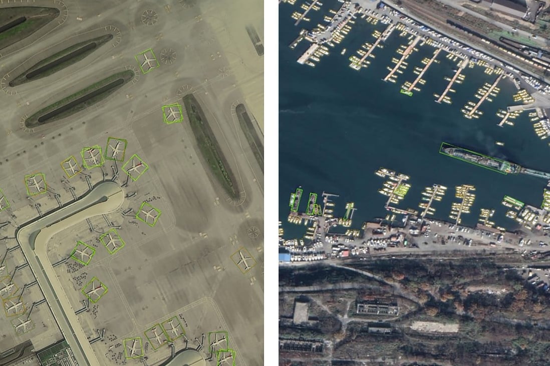
 The images were compiled with the help of access to China’s new Gaofen observation satellites.
Photo: Chinese Academy of Sciences
From SCMP by Stephen Chen
New FAIR1M database is tens or hundreds of times larger than previous data sets, according to Chinese Academy of Sciences
Database of 15,000 high-definition images with 1 million labelled ‘scenes’ can aid AI’s accuracy, such as enabling it to identify not only a plane but its model
A satellite imaging database containing detailed information of more than a million locations has been launched in China to help reduce errors made by
artificial intelligences when identifying objects from space, the Chinese Academy of Sciences said on Wednesday.
The fine-grained object recognition in the high-resolution remote sensing imagery (FAIR1M) database is tens or even hundreds of times larger than similar data sets used in other countries, it said.
Professor Fu Kun, a lead scientist on the FAIR1M project with the academy’s Aerospace Information Research Institute in Beijing, said the relatively small size of databases for artificial intelligence (AI) training in satellite image recognition had affected accuracy in real-life applications.
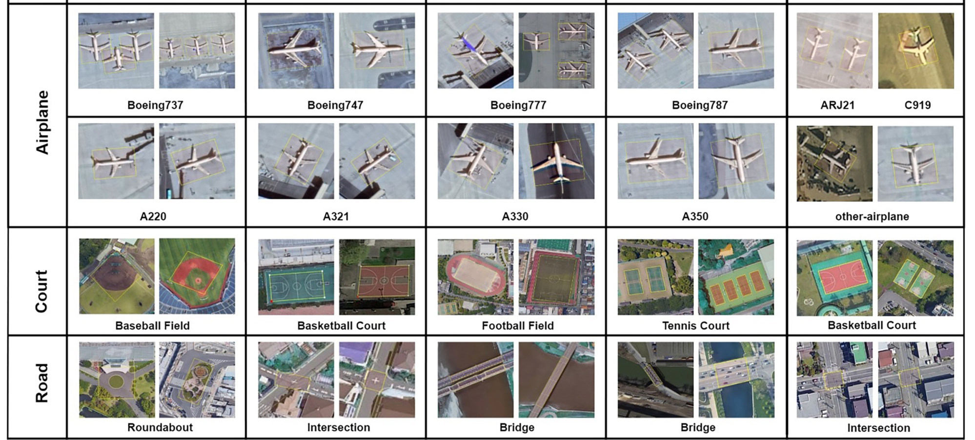
Satellite images in the data set have more specific labelling than in previous ones.
Photo: Chinese Academy of Sciences
“A challenging and excellent data set can accelerate the development of the field,” he and colleagues said in a paper about their work, posted on arxiv.org in March.
Militaries have used spy satellites to study objects of interest since the 1960s.
Assessment was initially done manually by trained professionals, before computers helped to speed up the process.
Military image recognition technology was mostly classified, and usually limited to a small range of sensitive objects.
In recent years, rapid development of AI technology has enabled civilians to obtain valuable information from commercial satellite images.
Counting the number of cargo trucks on the roads of a city or even a country, for instance, could provide insight into economic activity, transport and infrastructure.
Some researchers in China have used the technology to track the speed of city expansion in
Xinjiang, wild animal movements on the Tibetan Plateau and worldwide construction of infrastructure under the Belt and Road Initiative.
Existing AI algorithms have sometimes struggled to recognise objects in images taken from orbit, however.
Most civilian tools were trained using photographs taken in daily life, but an image of the Eiffel Tower taken by a tourist, for instance, would have little similarity to a shot taken from 300km (186 miles) above.
 The new data set will allow AI to distinguish between types of planes or sports facilities.
Photo: Chinese Academy of Sciences
The bigger a training database, the smarter the AI becomes.
But with satellite images being relatively limited in number and sometimes quite expensive, especially those in higher definition, the accuracy of AI remained quite low in civilian applications.
With funding from the China National Science Foundation and access to the brand-new
Gaofen observation satellites, Fu and colleagues built a database containing more than 15,000 high-definition satellite images with 1 million labelled “scenes”.
The VEDAI database in France has only about 3,600 scenes.
The whole Chinese data set will be open to the international community in June, and the International Society for Photogrammetry and Remote Sensing, whose headquarters is in Germany, has chosen it as a standard database to evaluate performance of object detection algorithms, according to the society’s website.
A satellite imaging database containing detailed information of more than a million locations has been launched in China to help reduce errors made by
The fine-grained object recognition in the high-resolution remote sensing imagery (FAIR1M) database is tens or even hundreds of times larger than similar data sets used in other countries, it said.
Professor Fu Kun, a lead scientist on the FAIR1M project with the academy’s Aerospace Information Research Institute in Beijing, said the relatively small size of databases for artificial intelligence (AI) training in satellite image recognition had affected accuracy in real-life applications.
“A challenging and excellent data set can accelerate the development of the field,” he and colleagues said in a paper about their work, posted on arxiv.org in March.
Militaries have used spy satellites to study objects of interest since the 1960s. Assessment was initially done manually by trained professionals, before computers helped to speed up the process.
Military image recognition technology was mostly classified, and usually limited to a small range of sensitive objects.
In recent years, rapid development of AI technology has enabled civilians to obtain valuable information from commercial satellite images.
Counting the number of cargo trucks on the roads of a city or even a country, for instance, could provide insight into economic activity, transport and infrastructure.
Some researchers in China have used the technology to track the speed of city expansion in
Xinjiang, wild animal movements on the Tibetan Plateau and worldwide construction of infrastructure under the
Belt and Road Initiative.
Existing AI algorithms have sometimes struggled to recognise objects in images taken from orbit, however. Most civilian tools were trained using photographs taken in daily life, but an image of the Eiffel Tower taken by a tourist, for instance, would have little similarity to a shot taken from 300km (186 miles) above.
The bigger a training database, the smarter the AI becomes.
But with satellite images being relatively limited in number and sometimes quite expensive, especially those in higher definition, the accuracy of AI remained quite low in civilian applications.
With funding from the China National Science Foundation and access to the brand-new
Gaofen observation satellites, Fu and colleagues built a database containing more than 15,000 high-definition satellite images with 1 million labelled “scenes”.
The VEDAI database in France has only about 3,600 scenes.
The whole Chinese data set will be open to the international community in June, and the International Society for Photogrammetry and Remote Sensing, whose headquarters is in Germany, has chosen it as a standard database to evaluate performance of object detection algorithms, according to the society’s website.
FAIR1M provides more information on images.
Other databases, for example, have described passenger planes as simply planes.
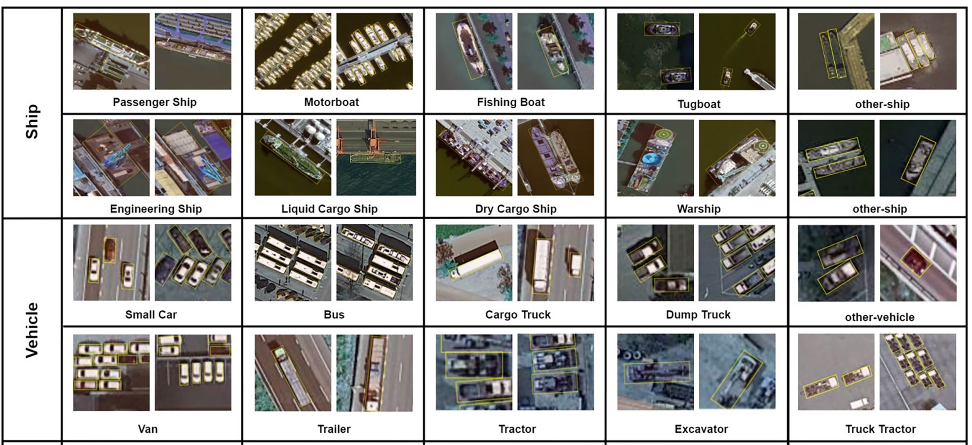
The new Chinese database could teach the AI a plane’s exact model, such as Boeing 777, or challenge it to distinguish a warship from a passenger ship.
“Building a large database is quite challenging,” said Xia Guisong, professor of remote sensing at Wuhan University, who was not involved in the FAIR1M project. “Objects need to be verified and properly labelled by hand.”
FAIR1M is not the only large-scale satellite image object database for AI in China.
The DOTA database developed by Xia’s team also contained a million scenes, but using fewer satellite images and labels. Xia said DOTA and FAIR1M were not competing with each other.
“We focused on objects viewed by satellites from different angles; they focused more on details in high resolution,” he said.
“These two data sets address different technical challenges. They complement one another.”
Military target recognition technology is believed to perform better than civilian counterparts, but the latter is catching up thanks to quickly evolving AI technology and improved training data.
“The algorithms that we develop work at fundamental levels,” Xia said, meaning they can be used in military or civilian settings.
Development of AI image recognition technology in China previously depended mostly on databases from other countries.
Now, with two of the world’s largest satellite image databases, China has a greater chance of gaining or maintaining a lead in the field.
“The database is a platform. On this platform any research team from any country can develop different algorithms to beat one another, according to certain rules,” Xia said.
“This will accelerate the pace of technology development as a whole.”
In the past, satellite images were collected mostly by Western countries.
Recently, China has built up one of the largest Earth observation networks with satellites such as the Gaofen series that were equipped with cutting-edge cameras and sensors.
More than 80 per cent of the images in the FAIR1M database came from the Chinese satellites, and the rest from Google Earth, according to Fu’s team.
They contained vehicles, machinery such as excavators, and constructions including bridges, roundabouts and baseball fields.
In May, AI researchers from many countries will compete in Beijing for a trophy awarded for satellite image recognition technology, using the FAIR1M database, the academy said.
The competition would “drive the development and application of China’s high-definition satellite image data and technology in international society”, it said.
Links :

No comments:
Post a Comment