While this data will still be presented seamlessly to users when displayed in ECDIS, it will result in improved consistency of both the scale of data and features within the ENCs.
From Admiralty
In
readiness for the next generation of navigational solutions, the UK
Hydrographic Office (UKHO) has embarked on a project to enhance the
content of its GB Electronic Navigational Charts (ENCs) and other
ADMIRALTY products.
This data improvement will enhance consistency, safety and the overall user experience for mariners. 
Preparing for a digital future
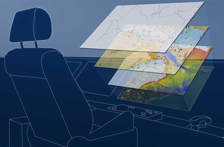
The UKHO is continuing to build the foundations to develop new ADMIRALTY digital solutions underpinned by the International Hydrographic Organization’s new data standard: S-100.
The UKHO is continuing to build the foundations to develop new ADMIRALTY digital solutions underpinned by the International Hydrographic Organization’s new data standard: S-100.
The standard will enable interoperable layers of data to seamlessly bring together a wide range of information, including next-generation ENCs (S-101), bathymetric surface data (S-102), water levels (S-104) and surface currents data (S-111).
Powered by satellite connectivity, this data will be delivered more dynamically and in near real-time to provide an even more accurate picture of the marine environment.
Undoubtably, this will bring significant safety and efficiency benefits including voyage optimisation for many users.
What is scheming?
In this case, a scheming refers to the scale of the data and position of the limits between individual products, such as paper charts or ENCs.
Existing GB ENCs (using the S-57 standard) currently use a scheme that has been derived from their paper chart origins.
What is scheming?
In this case, a scheming refers to the scale of the data and position of the limits between individual products, such as paper charts or ENCs.
Existing GB ENCs (using the S-57 standard) currently use a scheme that has been derived from their paper chart origins.
However, the new technical generation of ENCs (using the S-101 standard) will be compiled using a new, standardised gridded scheme to ensure seamless interoperability with other S-100 data sets.
Why rescheme existing ENC limits?
With S-101 ENCs becoming carriage compliant by 2026, the UKHO is now working to rescheme its S-57 GB ENCs into a gridded format in readiness for the transition.
Why rescheme existing ENC limits?
With S-101 ENCs becoming carriage compliant by 2026, the UKHO is now working to rescheme its S-57 GB ENCs into a gridded format in readiness for the transition.
By supplying data in a regular and consistent shape, this will enable additional information (using the S-100 data standard) to be overlaid in an interoperable ‘data stack’ in the future.
Rescheming will not only help prepare for future data products, but it will also result in a more consistent scheming and improved content for existing S-57 ENCs.
Rescheming will not only help prepare for future data products, but it will also result in a more consistent scheming and improved content for existing S-57 ENCs.
While data in current S-57 ENCs appears seamless when viewed by the mariner in ECDIS, its paper chart origins have resulted in some variation in scale and content when viewed across data limits, which we are aware has been noticed by the user community.
Current variations across data limits do not present any danger to today’s mariners.
Current variations across data limits do not present any danger to today’s mariners.
However, user feedback has shown that inconsistences can undermine confidence in the eyes of the navigator.
An example of this is variations in contour intervals.
For instance, one chart may display contour intervals of 2m, 5m, 10m, 15m and 20m, while an adjacent chart may only show intervals of 2m, 5m, 10m and 20m.
For instance, one chart may display contour intervals of 2m, 5m, 10m, 15m and 20m, while an adjacent chart may only show intervals of 2m, 5m, 10m and 20m.
While this does not present a danger, it can result in confusion when making navigational decisions; this is something the project seeks to address.
Our approach
Due to the paper chart origins of the current data limits, the data coverage does not match the limits of the grid when the new scheme is applied.
To put the mariners’ needs at the forefront of all decisions made, we are taking a flexible approach to this task.
With each instance of inconsistency, we have been asking: can the data be adjoined to the adjacent ENC?
With each instance of inconsistency, we have been asking: can the data be adjoined to the adjacent ENC?
Does it offer any useful information, or can it be deleted?
Or can any additional information be captured to complete a new ‘square’ of the grid?
By considering the unique requirements for each ENC cell, we have been able to make more flexible, user-oriented decisions to result in more harmonised, consistent coverage.
By considering the unique requirements for each ENC cell, we have been able to make more flexible, user-oriented decisions to result in more harmonised, consistent coverage.
At the heart of each decision, we have prioritised mariner safety and overall value.
Safety
To ensure the mariner has the information they need, we have been carefully assessing instances that may result in important features being divided across two separate ENCs. Similarly, we have considered where strategic decisions have been made in the original scheming to include certain navigational features, scales and sizes. Crucially, prior to any reschemed ENC being published, our teams have been conducting considerable testing to ensure they are fit for purpose.
We have been collaborating closely with stakeholders, such as local port authorities, to ensure they meet the needs of users. We are also engaging closely with other national hydrographic offices who use a gridded scheme and have found that regardless of the chosen scheming (i.e. paper chart scheme or gridded scheme) data will still be presented seamlessly to users when displayed in ECDIS.
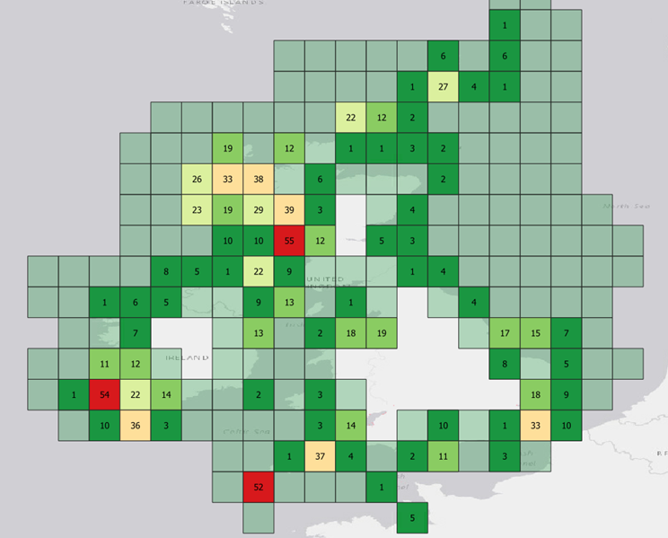
As the UKHO is responsible for providing coverage for UK waters and more than 63 nations worldwide, we recognise it is essential for this scheme to work successfully on a global scale and will be working with other national hydrographic offices across the globe to ensure alignment.
Value
As the rescheme is seeking to improve consistency and create more regular data limits, this will inevitably create more GB ENCs as a result.
Safety
To ensure the mariner has the information they need, we have been carefully assessing instances that may result in important features being divided across two separate ENCs. Similarly, we have considered where strategic decisions have been made in the original scheming to include certain navigational features, scales and sizes. Crucially, prior to any reschemed ENC being published, our teams have been conducting considerable testing to ensure they are fit for purpose.
We have been collaborating closely with stakeholders, such as local port authorities, to ensure they meet the needs of users. We are also engaging closely with other national hydrographic offices who use a gridded scheme and have found that regardless of the chosen scheming (i.e. paper chart scheme or gridded scheme) data will still be presented seamlessly to users when displayed in ECDIS.
As the UKHO is responsible for providing coverage for UK waters and more than 63 nations worldwide, we recognise it is essential for this scheme to work successfully on a global scale and will be working with other national hydrographic offices across the globe to ensure alignment.
Value
As the rescheme is seeking to improve consistency and create more regular data limits, this will inevitably create more GB ENCs as a result.
However, we have chosen to take a flexible approach as outlined above to ensure these rescheme ENCs will meet the informational needs of the mariner.
As part of our thorough testing process, we have conducted trials to ensure the size of each ENC best represents the navigational features and source data contained within it.
Improving GB ENC data
As part of this rescheming, the project has also presented opportunities to improve the data shown on the ENC in response to customer feedback:
Consistency - By identifying areas in which adjacent ENCs have different scale source data (and potentially different contour intervals or chart content), we are seeking to improve overall consistency of both the scale of data and the features within the ENCs.
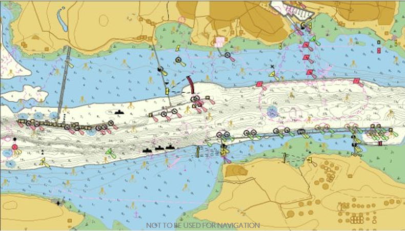
High density contours - We are also providing additional ‘high density’ ENCs for key areas (where supported by suitable data). These HD ENCs are contoured at 1m or 0.5m intervals, enabling the mariner to choose the most appropriate safety contour for the draught of their vessel and more clearly visualise navigable water – particularly in confined or shallow waterways.
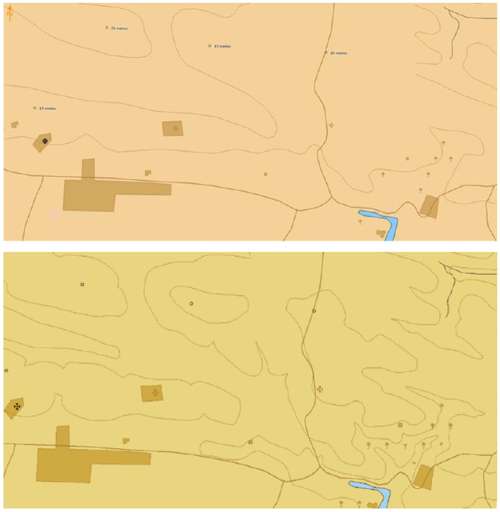
Enriched topography - User feedback has indicated that mariners would prefer more topographic detail as a visual reference (enabling them to match the information on their ECDIS and RADAR with the view out their window). Therefore, we have been able to enrich the interval frequency of topographic contours and update urban areas, as shown.
What progress has been made so far?
We have already published the first reschemed ENCs, containing improved coverage of Milford Haven in Wales – a large port frequented by oil, chemical and LNG tankers, as well as pleasure and sailing vessels.
Here, we worked closely with pilots at the Port of Milford Haven to consider their local knowledge when focusing on the area.
This data improvement resulted in the publication of new HD ENC coverage, which was developed and tested with the Port Authority.
These new ENCs will enable ships to navigate with enhanced precision and greater confidence of their under-keel clearance.
Representatives from the Port of Milford Haven commented:
“The HD ENCs have been absolutely fantastic. Choke point areas in the past have now gone as a result of the user having more water space; the pilots are now using parts of the channel that they wouldn’t have used in the past.”
What's next?
Representatives from the Port of Milford Haven commented:
“The HD ENCs have been absolutely fantastic. Choke point areas in the past have now gone as a result of the user having more water space; the pilots are now using parts of the channel that they wouldn’t have used in the past.”
What's next?
Addressing inconsistences and variations in data is a necessary step in the transition towards S-101 ENCs.
Once the coverage has been successfully reschemed, the UKHO will be in a position to begin converting S-57 data into S-101 in readiness for future ECDIS carriage compliance regulations in 2026, in line with its ambitions to be at the forefront of the development of next-generation data solutions.
Links :
- GeoGarage blog : Rescheming NOAA ENCs is underway. What does that mean?
No comments:
Post a Comment