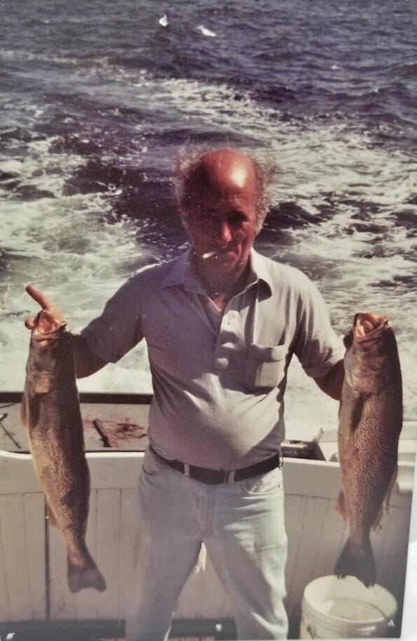
Saturday, September 21, 2019

Heavy lift ship raises Carnival Vista out of the water


In a 12-hour evolution on Saturday, the Boskalis semi-submersible heavy lift ship BOKA Vanguard successfully floated the cruise ship Carnival Vista aboard in order to facilitate repairs at a shipyard in the Bahamas.


The BOKA Vanguard is the largest vessel of her type, and she has enough capacity to lift and carry the 4,000 passenger Carnival Vista.
The Vista is experiencing technical difficulties with her azipods, and she needs to be drydocked in order to carry out the repairs.
After the loss of Grand Bahama Shipyard's largest floating drydock in April, the nearest conventional solution for drydocking a vessel of Vista's size would be overseas - but the Vanguard could come right to the site.
She will serve as a temporary drydock while repairs are carried out, and the Vista will only be out of service for 17 days and three sailings.
The cruise ship is expected to resume her normal schedule later in the month.

Friday, September 20, 2019

When you teach a boy to fish

 Uncle Tony.
Photos courtesy of the author.

From Medium by Carl Safina

How my uncle’s generosity — and love of the sea — inspired me for a lifetime

Sometimes, early planted seeds that will germinate decades later into a writer’s life are planted by sources neither formal nor literary. Indeed mine were neither.
I had Uncle Tony.
What Uncle Tony had: An untrained eye for the beautiful and a willingness to share a little time near water.

But now he’s in a two-person room on the far side of the curtain.
Our visit is mostly a surprise.
As we file past the partition Tony takes in his visitors. It’s my mother, me…
“Here’s a person I haven’t met,” he says as we fully materialize.
“My wife,” I say, and before I can add, “Patricia,” he points to a photo of her on the wall, on a boat, holding up a halibut.

Tony had always been drawn to the sea, to boats, and to fish.
That drew me to him.
But today is only the third time I’ve seen my uncle in 10 years.
He’s not much of a talker so I seldom call.
At age 87 he’s got diabetes, recently pneumonia, everything hurts.
He refuses to complain and his energy is limited.
So the calls, which he always ends with, “I love you,” are short.

We all know he will not go home.
I feel ashamed that this is only our second visit here, and that he’s not previously met my wife of five years, considering how much a few brief experiences I’d had with him when I was in my teens have meant to me.
Recently he’d suffered several days of hallucinations.
His stepdaughter, Emily, advised we come soon.
Thus this hastily arranged trek to Staten Island.
I’ve been bracing for how we’d find him. But, though physically diminished, he is mentally very much himself.

Tony’s roommate has his TV tuned to a game show that he’s not watching, like everyone on this floor.
Except for my uncle, whose TV is never on.
He’s got the window, a view of distant Raritan Bay, and he’s got his wall of photos.

A crowd is gathered in front of a Brooklyn tenement on the day the government declared the end of World War II.
“That’s me, that kid on the right, half-hidden by the flag.”
The next photos of him are in military clothes in Korea.
There’s Josephine on the boat, fishing rod in hand, the late-arriving love of his life beaming her eternal smile.
In fact, the majority of the photos that keep him company are of people in boats with sunlit faces.

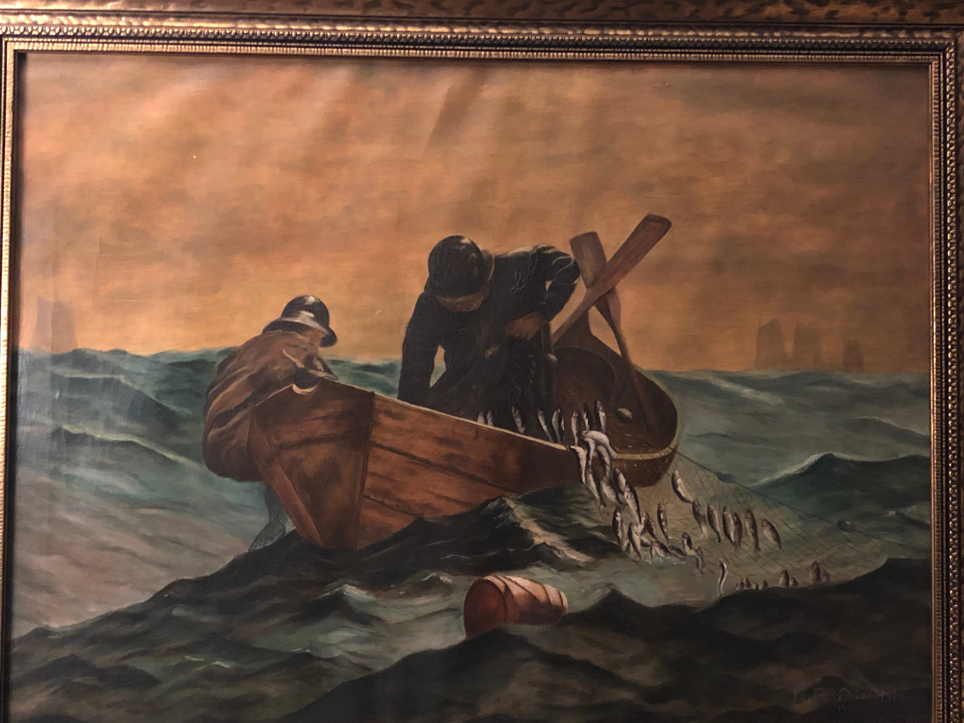
 Uncle Tony’s copy of “The Herring Net”

It had momentarily slipped my wife’s mind that it was Tony who had painted the masterful reproduction of Winslow Homer’s The Herring Net that dominates our living room.
Next to his signature is the year, 1962.
“When I brought that painting home and you saw it,” Tony recalls with a chuckle as he adjusts his oxygen tube, “you said right then, you wanted it”
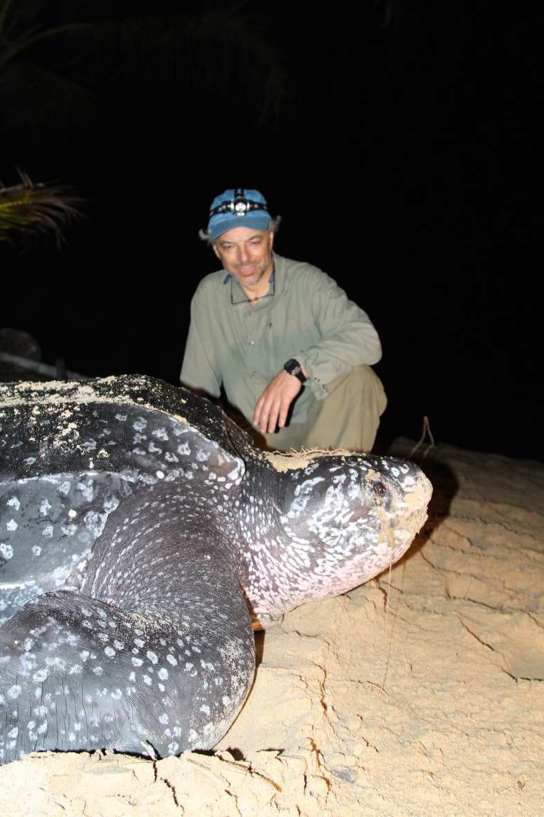
“Huge turtle?” Patricia picks up.
“What was it, a big snapper?” “Leatherback,” he says.
“You saw a leatherback? Where?”
“We were off the Rockaways that day.”

I was 14, so it was 1969.
We were fishing for tuna a few miles offshore — as you could in those days — within sight of Brooklyn.
Tuna fishing is hours of waiting that, sometimes, instantly turns into out-of-control pandemonium. I was wound with suspense.
Studying the sea surface for any swirl or fin, I noticed the mild chop breaking over something just under the surface.
Suddenly a surreal, mechanical-looking head the size of my torso lifted from the sea-foam and gasped a deep breath — it was a thousand-pound leatherback, by far the world’s largest sea turtle. The indelible sight never left my mind.

 Author and the turtle

Tuna fishing is hours of waiting that, sometimes, instantly turns into out-of-control pandemonium.
Tony turns to me and says, “I never really got a great look at it when it was under the boat. I backed up when we cut the line.”
Soon after it had come up for air, it tangled in our heavy fishing line close to the boat.
I bent over the gunwale and got a clear look at its massive soft shell and angelic flippers.
An unstoppable force, it was quickly cut loose.
“You gave me a lot of work to do by getting me to see that leatherback,” I say.
Thirty-five years later my book Voyage of the Turtle was published.
“I went to see leatherback turtles nesting and migrating on three continents and in three oceans. Then we did the PBS show. You know how much time and money that all cost?”
“Sorry,” he says with mock sarcasm.
“Excellent book by the way,” he adds, surprising me a bit.

“And that was after the tuna fishing itself made me decide to write my first book,” I add.
“Hey, do you remember the article I wrote for Sea Frontiers?”
I had beamed with pride when I showed it to him, about 20 years after I’d pored through his magazines.
He doesn’t remember.
He’s getting tired.
We get up to say bedside goodbyes.

Patricia tells him she is so glad she’s finally met him and how much we enjoy having his painting of The Herring Net.
It’s so expertly done, you’d think it was the original.
“I gave them a few extra herring,” he confides.

For a man who never had the means for much generosity, he did what he could for the fishermen on the canvas, and the result has lasted decades.
About what he did for me, the same applies.
I want to kiss him.
But the cluttered reach to him in bed is awkward; I’m afraid of yanking on a tube.
I take his hands and say goodbye and walk into the hall.
I’m putting on my coat when Patricia overhears Uncle Tony say to his 93-year-old sister, “I guess this is the last time I’ll see ya.”
“You didn’t kiss him,” Patricia has also noticed.
I march back in and without mishap, I give him a kiss on his stubbled cheek.
It crosses my mind that this might be the first time I’ve ever kissed him.
“Thanks for that,” he says.
“Thank you.” I was seven years old. I had to wait for 50 years.

My uncle’s extraordinary talent for painting came to him effortlessly.
Unfortunately, nothing else did.
He was almost five when my immigrant grandfather hanged himself in their Brooklyn apartment, plunging a seamstress with four kids aged two to 11 into dire poverty, setting the family on a stagger from which no one ever quite recovered.
Despite enormous ability, painting was never more than a temporary avocation for my uncle, and after a few years he put his brushes down.
He’d been a starving child; he couldn’t afford to become a starving artist.
He bounced around a bit.
Eventually, he got a steady job in a boating supplies store in Sheepshead Bay, a paycheck he stuck with for as long as he worked.
I never saw him much but his interest in the sea interested me.
When I was 14, I decided to take a vacation: four days in my grandmother’s Brooklyn apartment just so I could hang out with Uncle Tony.
In his Mustang we drove to the New York Aquarium, where we marveled at the improbable sizes of old and obese specimens of fish that we loved to catch.
I snapped photos of doormat-sized fluke, bucket-sized black sea bass, and striped bass like logs.
At his home, I pored through his stacks of Sea Frontiers, an early magazine of scientific discovery for nonscientists.
Best of all, I was invited aboard Happy Days, the boat owned by Tony, my Uncle Sal, and a friend.
“You remember that huge turtle?” he says, knowing where this conversation will go.

Thursday, September 19, 2019

How Magellan circumnavigated the globe

On September 6, 1522, the "Victoria" sailed into harbor in southern Spain.
The battered vessel and its 18 sailors were all that remained of a fleet that had departed three years before.
Yet her voyage was considered a success, for the "Victoria" had achieved something unprecedented – the first circumnavigation of the globe.


One of Ferdinand Magellan’s five ships–the Vittoria–arrives at Sanlucar de Barrameda in Spain, thus completing the first circumnavigation of the world.
The Vittoria was commanded by Basque navigator Juan Sebastian de Elcano, who took charge of the vessel after the murder of Magellan in the Philippines in April 1521.
During a long, hard journey home, the people on the ship suffered from starvation, scurvy, and harassment by Portuguese ships.
Only Elcano, 17 other Europeans, and four Indians survived to reach Spain on the 6th September 1522.

Victoria, the sole ship of Magellan's fleet to complete the circumnavigation.
Detail from a map by Ortelius, 1590.

On September 20, 1519, Magellan set sail from Spain in an effort to find a western sea route to the rich Spice Islands of Indonesia.
In command of five ships and 270 men, Magellan sailed to West Africa and then to Brazil, where he searched the South American coast for a strait that would take him to the Pacific.
He searched the RÍo de la Plata, a large estuary south of Brazil, for a way through; failing, he continued south along the coast of Patagonia.
At the end of March 1520, the expedition set up winter quarters at Port St. Julian.
On Easter day at midnight, the Spanish captains mutinied against their Portuguese captain, but Magellan crushed the revolt, executing one of the captains and leaving another ashore when his ship left St. Julian in August.
The Magellan–Elcano voyage. Victoria, one of the original five ships, circumnavigated the globe, finishing three years after setting out.


 Commemorative Chart of the Fifth Centenary of the Voyage of the Earth's Circum-Navigation, Magalhães (Magellan)-Elcano (1519-1522)
As part of the celebrations of the 5th Centenary of the Magalhães and Elcano Earth Circum-Navigation, the Portuguese Navy joined the program through the development of several projects. One of the projects, under the coordination of the Portuguese Hydrographic Institute, consisted in the elaboration of a Commemorative Chart whose historical component was coordinated by the Naval Research Center of the Naval Academy and the History Center of the University of Lisbon.
In this context, on the occasion of the commemoration of the 500th anniversary of the departure from Sanlúcar de Barrameda of the navy force commanded by the Portuguese Navigator Fernão de Magalhães (September 20, 1519), the Portuguese Newspaper “Jornal Expresso”,will promote the distribution of a version of the Commemorative Chart in his next edition of September 21th, 2019.

On October 21, he finally discovered the strait he had been seeking.
The Strait of Magellan, as it became known, is located near the tip of South America, separating Tierra del Fuego and the continental mainland.
Only three ships entered the passage; one had been wrecked and another deserted.
It took 38 days to navigate the treacherous strait, and when ocean was sighted at the other end Magellan wept with joy.
He was the first European explorer to reach the Pacific Ocean from the Atlantic.
His fleet accomplished the westward crossing of the ocean in 99 days, crossing waters so strangely calm that the ocean was named “Pacific,” from the Latin word pacificus, meaning “tranquil.”
By the end, the men were out of food and chewed the leather parts of their gear to keep themselves alive.
On March 6, 1521, the expedition landed at the island of Guam.

Ten days later, they dropped anchor at the Philippine island of Cebu–they were only about 400 miles from the Spice Islands.
Magellan met with the chief of Cebú, who after converting to Christianity persuaded the Europeans to assist him in conquering a rival tribe on the neighboring island of Mactan.
In subsequent fighting on April 27, Magellan was hit by a poisoned arrow and left to die by his retreating comrades.

A 1561 map of America showing Magellan's name for the pacific, Mare pacificum,
and the Strait of Magellan, labelled Frenum Magaliani.

After Magellan’s death, the survivors, in two ships, sailed on to the Moluccas and loaded the hulls with spice.
One ship attempted, unsuccessfully, to return across the Pacific.
The other ship, the Vittoria, continued west under the command of Juan SebastiÁn de Elcano.
The vessel sailed across the Indian Ocean, rounded the Cape of Good Hope, and arrived at the Spanish port of SanlÚcar de Barrameda on September 6, 1522, becoming the first ship to circumnavigate the globe.
The Vittoria then sailed up the Guadalquivir River, reaching Seville a few days later.

Elcano was later appointed to lead a fleet of seven ships on another voyage to Moluccas on behalf of Emperor Charles V.

Wednesday, September 18, 2019

Collector’s 400 years of China maps and nautical charts up for sale – there’s not a nine-dash line to be seen

Robert Nield (left) and Jonathan Wattis with a selection of historical maritime maps
on show at Wattis Fine Art in Hong Kong’s Central district.
Nield is selling much of his collection of maps and charts.
Photo: Jonathan Wong

From South China Morning Post by Annemarie Evans

Pearl River Delta depth charts, Macau street maps from Lord Macartney’s embassy to post-war era, the first map showing Singapore – collection has it all
For Robert Nield, past president of the Royal Asiatic Society Hong Kong, the sale, brought on by he and his wife moving to a smaller flat, is bittersweet

The French chart follows the Pearl River estuary to the city of Canton.

Printed in 1844 as an aid to ship navigation, it’s a chart made for practicality, not aesthetics – to be rolled out on a ship bridge, pored over, a forefinger tracking a route, used in tandem with a sextant – and the basis for a quick discussion with the captain and instructions given to the crew.

At the time it was made the British colony of Hong Kong was just three years old.

There’s a city plan of Canton (now Guangzhou) at the top, also one of Macau, by then a Portuguese enclave for 300 years.
Up and down the line of the coast numerous numbers have been painstakingly added.
These are depths in fathoms (one fathom is 1.8 metres or 6ft), measured since the early days of seafaring by a plumb line – a rope with a lump of lead on the end that was dangled over the side of a survey ship to calculate the depth of the sea at key points for vessels tracking along the coast.

The French chart Carte de la Riviere de Canton, printed in 1844
and part of the Robert Nield collection.
Photo: Wattis Fine Art

Long before satellites and aerial photography, sailing ships would tack back and forth measuring depths, their crews’ accurate but painstaking work – which sometimes took months – providing an indication of where shifting sands lay.

This has always held a fascination for Robert Nield, a past president of the Royal Asiatic Society Hong Kong and the author of two books on China’s former treaty ports.
Nield spent 37 years putting together a collection of more than 50 maps and charts of Hong Kong, Macau and the surrounding region, many of which are now on sale and feature in an exhibition at Wattis Fine Art in Hong Kong’s Hollywood Road.

A close up-of Victoria Harbour from the 1844 Carte de la Riviere de Canton map.
Photo: Wattis Fine Art

“You can see the tracks of where the survey ship went and it dropped its plumb line over the side, and this one was 10 fathoms, this one was nine fathoms, so you can see exactly the track that the ship followed,” says Nield.
“I love this precision of seeing where the ship went.
It was probably the way the wind was blowing, because they tacked this way and then they tacked that way.”

The “Carte de la Rivière de Canton”, published by France’s Depot-general de la Marine, is one of the more practical charts in Nield’s collection.
South of the mouth of the Pearl River is the “Ile de Hong Kong”, surrounded by dozens of depth readings.

“These charts would be updated, and the old ones then thrown away,” says antiquarian dealer Jonathan Wattis.

A chart of the Pearl River Delta dated 1794.
Photo: Wattis Fine Art

By the late 18th century, maps had become increasingly accurate.
Earlier ones give a fascinating insight into how this part of the world was seen.
Not all were made for navigators; some were bound into atlases and perused by the rich in their libraries.

The maps also offer a history lesson, showing which European countries were the dominant traders and colonisers in East Asia at any given time.

Holland grew rich on the trade in spices and other products, so there was plenty of money in Amsterdam by the 17th century to sponsor a thriving community of great artists and mapmakers.
The Blaeu family of Amsterdam was the pre-eminent example of this – globally regarded, says Wattis, as the best mapmakers of their time.
Nield has a beautiful example of their work.

Holland’s Willem Blaeu launched a dynasty of mapmakers.
Photo: Alamy

“Willem Blaeu set up a dynasty of mapmakers,” Wattis explains.
“They produced arguably the most beautiful maps, engraved and beautifully hand-coloured at the time, and they became mapmakers to the Dutch East India Company, which was an extremely wealthy organisation, so they had very good patronage.”

Nield’s map of Guangdong is from Martino Martini’s Novus Atlas Sinensis (New Atlas of China, 1655).

“The atlas of China was based on Jesuit and Chinese surveys in 1655,” says Wattis.
“One of the Jesuits, called Martini, took it to Amsterdam, to the Blaeu family, so Martini was the messenger.
But there were a number of Jesuits working in different provinces and they were acquiring information as they went along, obviously from Chinese sources, but in Guangdong also from Portuguese sources.”

A map of Guangdong from Martino Martini’s Novus Atlas Sinensis (New Atlas of China, 1655).
Photo: Wattis Fine Art

The Wattis Fine Art exhibition “Mapping of Asia” includes the Robert Nield Collection, plus other treasures.
Nield’s maps and charts covered walls of his home and office in Hong Kong where he worked until he retired.
He and wife, Janet, are now relocating to a flat half the size of their current accommodation, and 400km (250 miles) from Vancouver in Canada, so he has had to make some tough decisions.
He has kept a few of his maps, and the rest are for sale.

Highlights include the first detailed Dutch chart of the Pearl River Delta, depicting Canton, Macau and the islands around Hong Kong, by Johannes van Keulen, created in Amsterdam in 1753, and rarely seen on the market.
Nield is also parting with an English chart of the Pearl River Delta from 1794, which is one of the earliest to name Hong Kong – “He-ong Kong”.

“Towards the end of the 18th century, charts of the Pearl River were becoming more detailed and accurate,” says Wattis, pointing out a chart of the upper part of the narrow strait in the Pearl River Delta known as the Bocca Tigris (the Tiger’s Mouth) and Canton, using a survey by Captain J. Huddart and printed in 1786.

A stand-out in Nield’s collection is a plan of Macau which was published in an account of an embassy sent by the British to China under Lord Macartney in 1793-5 that offers an early glimpse into Sino-British relations.
A later British cartographer and publisher, James Imray, created some of the best nautical maps of his time.
Nield has a chart of the “Channels to Hong Kong and Macao” printed in 1887, which was used by Imray.

For Nield, the sale marks a bittersweet parting.
He feels the joy of the collection was in the collecting, via friends in the art and antiquarian worlds, auction houses and through word of mouth.

While many of his framed charts were carefully positioned on his walls, some stood on the floor of a third-floor flat in the city’s Mid-Levels neighbourhood some years ago.
“And it flooded,” he says.
So some of the charts and maps have a tide water mark due to early 21st century Hong Kong plumbing.
Wattis persuaded Nield to include these for their historic interest and also as “starter” material for collectors.

An Indiae Orientalis map dated 1587.
Photo: Wattis Fine Art

The “Mapping of Asia” exhibition includes charts and maps created between the late 16th century and 1949, among them a folding tourist map of Macau.
The cover is stamped SS Takshing, which was a post-World War II Macau-Hong Kong ferry.

The oldest item in the exhibition, and one of the most fascinating, is a beautiful engraving of Southeast Asia by Abraham Ortelius.
Titled Indiae Orientalis Insularumque Adiacientium Typus, it was printed in Antwerp, in present-day Belgium, in 1587.

Abraham Ortelius (1527-1598), a Flemish cartographer and creator of the first modern atlas, Theatrum Orbis Terrarum (Theatre of the World).

“It includes China and India and Japan,” says Wattis.
“In the top left hand corner is the Portuguese coat of arms, as a lot of the information is based on early Portuguese reports.
In the sea you have these wonderful things, including a mythical whale which seems to be attacking a galleon.”

Wattis also displays the oldest recorded map of Singapore, which shows a naval battle between the Dutch and the Portuguese that took place in the Malacca Strait in 1602, and which was published by the De Bry family in Frankfurt in 1607.

The Battle of Swally, dated 1739.
Photo: Wattis Fine Art

Plenty of battle scenes are shown in the exhibition’s engravings, including another naval battle between the Dutch and the Portuguese in the early 1600s off northern Java.
It’s a battle for the Spice Islands, won by the Dutch, which would change the colonial make-up of Asia at that time.

“There are so many ships at close quarters, and so many ships in the distance and you can just see the coastline of Java,” says Wattis.
“The Dutch won and it became the Dutch East Indies.”

The exhibition is also a testament to the navigational skills of intrepid early cartographers and mariners.
One engraving Wattis has of a ship struggling precariously in high seas is an indication of the dangers faced by the many vessels that never made it back to port.

Links :

Tuesday, September 17, 2019

Fukushima fishermen concerned for future over release of radioactive water

Last year’s catch was just 16% of pre-crisis levels, partly because of the Japanese public’s reluctance to eat fish caught off Fukushima due to the radioactive water.
Photograph: Koji Ueda/AP

From The Guardian by Justin McCurry

Eight years after the triple disaster, Japan’s local industry faces fresh crisis – the dumping of radioactive water from the power plant

On the afternoon of 11 March 2011, Tetsu Nozaki watched helplessly as a wall of water crashed into his boats in Onahama, a small fishing port on Japan’s Pacific coast.

Nozaki lost three of his seven vessels in one of the worst tsunamis in Japan’s history, part of a triple disaster in which 18,000 people died.
But the torment for Nozaki and his fellow fishermen didn’t end there.
The resulting triple meltdown at the nearby Fukushima Daiichi nuclear power plant forced the evacuation of more than 150,000 people and sent a plume of radiation into the air and sea.

It also came close to crippling the region’s fishing industry.

Having spent the past eight years rebuilding, the Fukushima fishing fleet is now confronting yet another menace – the increasing likelihood that the nuclear plant’s operator, Tokyo Electric Power (Tepco), will dump huge quantities of radioactive water into the ocean.

“We strongly oppose any plans to discharge the water into the sea,” Nozaki, head of Fukushima prefecture’s federation of fisheries cooperatives, told the Guardian.

Nozaki said local fishermen had “walked through brick walls” to rebuild their industry and confront what they say are harmful rumours about the safety of their seafood.
Last year’s catch was just 16% of pre-crisis levels, partly because of the public’s reluctance to eat fish caught off Fukushima.

  Storage tanks for radioactive water at the Fukushima Daiichi nuclear power plant.
Photograph: Issei Kato/Reuters

Currently, just over one million tonnes of contaminated water is held in almost 1,000 tanks at Fukushima Daiichi, but the utility has warned that it will run out of space by the summer of 2022.

Tepco has struggled to deal with the buildup of groundwater, which becomes contaminated when it mixes with water used to prevent the three damaged reactor cores from melting.
Although the utility has drastically reduced the amount of wastewater, about 100 tonnes a day still flows into the reactor buildings.

Releasing it into the sea would also anger South Korea, adding to pressure on diplomatic ties already shaken by a trade dispute linked to the countries’ bitter wartime history.

Seoul, which has yet to lift an import ban on Fukushima seafood introduced in 2013, claimed last week that discharging the water would pose a “grave threat” to the marine environment – a charge rejected by Japan.

Fukushima fisheries officials point out that they operate a stringent testing regime that bans the sale of any seafood found to contain more than 50 becquerels of radioactive material per kilogram – a much lower threshold than the standard of 100 becquerels per kilogram observed in the rest of Japan.

Just over one million tonnes of contaminated water is held in almost 1,000 tanks at Fukushima Daiichi.
Photograph: Koji Ueda/AP

At Onahama’s testing centre, just metres from where the catch is unloaded, eight employees conduct tests that last between five and 30 minutes depending on the size of the sample.
“Tepco has said that the water can be diluted and safely discharged, but the biggest problem facing us is the spread of harmful rumours,” Hisashi Maeda, a senior Fukushima fisheries official, said as he showed the Guardian around the facility.

Confirming Maeda’s fears, almost a third of consumers outside Fukushima prefecture indicated in a survey that dumping the contaminated water into the sea would make them think twice about buying seafood from the region, compared with 20% who currently avoid the produce.

Tepco’s Advanced Liquid Processing System removes highly radioactive substances, such as strontium and caesium, from the water but the system is unable to filter out tritium, a radioactive isotope of hydrogen that coastal nuclear plants commonly dump along with water into the ocean.
In addition, Tepco admitted last year that the water in its tanks still contained contaminants beside tritium.

Supporters of the discharge option have pointed out that water containing high levels of tritium, which occurs in minute amounts in nature, would not be released until it has been diluted to meet safety standards.

But Shaun Burnie, a senior nuclear specialist with Greenpeace Germany who regularly visits Fukushima, said a proportion of radioactive tritium had the potential to deliver a concentrated dose to cell structures in plants, animals or humans.
“Dilution does not avoid this problem,” he said.

Rows of black bags at a soil storage facility in Fukushima.
Not a single location in the entire country has agreed to accommodate the toxic waste.
Photograph: Issei Kato/Reuters

Burnie believes the solution is to continue storing the water, possibly in areas outside the power plant site – a move that is likely to encounter opposition from nuclear evacuees whose abandoned villages already host millions of cubic metres of radioactive soil.

“There is no short-term solution to the water problem at Fukushima Daiichi, as groundwater will continue to enter the site and become contaminated,” Burnie said.
“A major step would be for the government to start being honest with the Japanese people and admit that the scale of the challenges at the site mean their entire schedule for decommissioning is a fantasy.”
‘No other option’

Government officials say they won’t make a decision until they have received a report from an expert panel, but there are strong indications that dumping is preferred over other options such a vaporising, burying or storing the water indefinitely.

Shinjiro Koizumi, the new environment minister, has not indicated if he shares his predecessor’s belief, voiced last week, that there is “no other option” but to discharge the water into the sea.

The International Atomic Energy Agency has recommended that Japan release the treated water, while Toyoshi Fuketa, the chairman of Japan’s Nuclear Regulation Authority, said a decision on its future must be made soon.
“We are entering a period in which further delays in deciding what measure to implement will no longer be tolerable,” Fuketa said, according to the Asahi Shimbun.

Putting off a decision could delay work to locate and remove melted fuel from the damaged reactors – a process that is already expected to take four decades.

Critics say the government is reluctant to openly support the dumping option for fear of creating a fresh controversy over Fukushima during the Rugby World Cup, which starts this week, and the buildup to the 2020 Tokyo Olympics.

Nozaki said he and other fishermen throughout Fukushima would continue the fight to keep the water out of the ocean.
“Releasing the water would send us back to square one,” he said.
“It would mean the past eight years have amounted to nothing.”

Links :