Saturday, January 27, 2018

ECMWF 25 years of ensemble prediction fro weather

Lead Scientist Roberto Buizza, Director-General Florence Rabier and NOAA meteorologist Tom Hamill explain the rationale behind ensemble forecasting and set out what the future holds. 

Links :

Friday, January 26, 2018

Hydrography in the 70's

Before the arrival of GPS and satellites :
follow a team of SHOM hydrographers which will carry out a coastal mapping point using techniques from the 1970s, including optical radio guidance.

Ancient maps show islands that don't really exist

The fictional island Frisland appears in the lower left corner of this 1596 map of the Arctic
by Gerardus Mercator.
Image courtesy of the Osher Map Library and Smith Center for Cartographic Education at the University of Southern Maine

From National Geographic by Greg Miller

For centuries, mapmakers have conjured up islands that only exist in the imagination.

The treaty that drew the first borders of the newly established United States after the Revolutionary War refers to an island that does not exist.
The northern boundary of the new nation, the 1783 Treaty of Paris declared, shall pass “through Lake Superior northward of the Isles Royal and Phelipeaux.”
It sounds clear enough, but when surveyors went out to map the border in the 1820s they discovered a problem: Isle Phelipeaux was not there.

The story behind the nonexistent island Brasil, shown on this 1633 map in the Atlantic Ocean west of Ireland (far left), is a mystery.

The long and fascinating history of such phantom islands is the topic of Malachy Tallack’s new book, The Un-Discovered Islands, which he discussed recently in an interview with National Geographic. Inspired by the book, we’ve rounded up a collection of vintage maps that feature islands that don’t actually exist.

Saint Brendan, an early Christian monk, is the namesake of a nonexistent island in the North Atlantic (right of center, near the top). 
He’s also reputed to have held mass on the back of a whale, as shown on this 1621 map.

“Frisland,” for example, appears to have been the invention of a wealthy Venetian named Niccolò Zeno, who wrote a book in 1558 claiming that his ancestor had discovered the New World before Columbus.

This detail from a 1558 map that accompanied Niccolò Zeno’s dubious book, in which he claimed that his ancestor discovered the New World before Colombus, shows the faux island of Frisland (left of center, near the bottom).

Historians now consider the claim bogus, but it was influential at the time, and the islands it described appeared on maps for more than a century.

Gerhard Mercator included a circular inset map of Frisland, complete with several nonexistent towns, on his 1595 map of the region around the North Pole.

This was, after all, the era when people were just beginning to explore the world’s oceans, and news traveled slowly by modern standards.

This 1720 map shows the mythical island of Thule, first reported by the Greek explorer Pytheas around 330 B.C., off the north coast of Scotland and in the inset at top left.

Some islands were believed to have existed and later sunk. Sarah Ann Island, a speck of land in the Pacific Ocean claimed by the United States under the 1856 Guano Act, a law permitting the appropriation of islands covered with bird droppings (a valuable source of fertilizer at the time).
The island happened to be in the path of a total solar eclipse in 1937, but when astronomers went to seek it out, the island was gone.
Most likely it had never been there, but newspapers reported that it had sunk, and the rumor stuck.

For centuries, mapmakers drew California as an island, as in this Dutch map from 1689.

Other “un-discovered” islands, like Phelipeaux, appear to be the result of outright fraud.
This island appears on a map by a Virginia-born British loyalist named John Mitchell that was used by both sides to negotiate the Treaty of Paris (see below).

 Four nonexistent islands are visible in this detail from John Mitchell’s map: Phelippeaux, Pontchartrain, Maurepas, and St. Anne.

Mitchell isn’t at fault for the faux island, however.
He simply copied the island from an older map.
The island’s name, together with the names of three other nonexistent Lake Superior islands, Pontchartrain, Maurepas, and St. Anne, betray the origin of the ruse.
In the 1720s, a count named Jean-Frédéric Phélypeaux had served as a French secretary of state.
He happened to have estates named Pontchartrain and Maurepas, and his family’s patron saint just happened to be St. Anne.
Apparently, someone was kissing up to the count by inventing islands named in his honor.
The sycophant appears to have been an explorer named Pierre François Xavier de Charlevoix, whose voyages in the region had been funded by the good count Phélypeaux.
The four imaginary islands first appear on a map commissioned for a book published by Charlevoix in 1744.
The fraud went undetected for nearly a century until another treaty finally erased them from maps for good in 1842.
“This little lie that an explorer told became entangled in a really important part of history,” Tallack says.
“I find that really fascinating.”

Sandy Island, which appears in the top left corner of this 1921 National Geographic map, was “un-discovered” once and for all in 2012.
 The same 1921 map depicts Morell Island, which doesn’t appear on modern maps, at the far northwest end of the Hawaiian Island chain.

One of the most recent island un-discoveries happened in 2012, when an Australian research vessel reported that Sandy Island, which maps depicted off the coast of New Caledonia in the South Pacific, was most definitely not there.
Within weeks the National Geographic Society announced that Sandy Island would be stricken from all of its maps, and other mapmakers followed suit.
Google removed Sandy Island from its maps, too, but people continued to post photos at its former location.
The photos were mostly meant as a joke, Tallack says, but they also hint at the powerful pull islands exert on the human imagination.
“Because their borders are well defined we can project our ideas onto them much more easily than we can with other places.”

Links :

Thursday, January 25, 2018

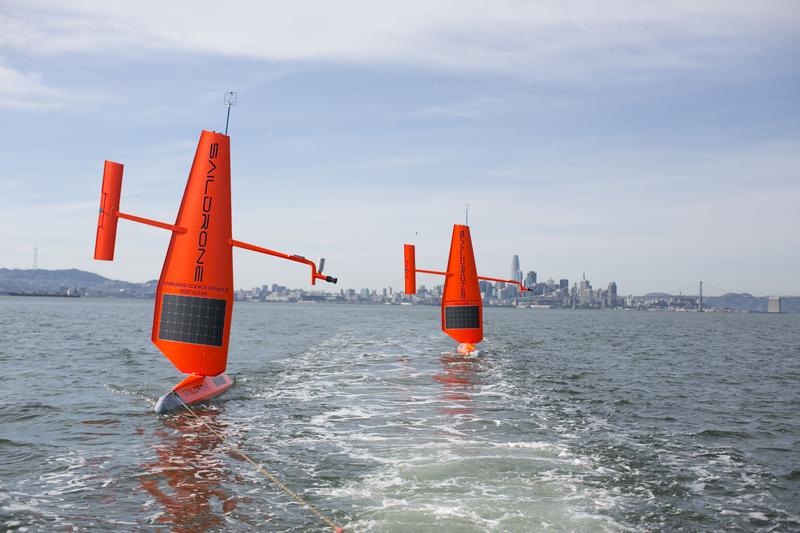
CSIRO to launch 'sailing drones' to monitor Southern Ocean


Autonomous, ocean-going vessels have been launched from Alaska for oceanic research in the Bering Sea.
NOAA has partnered with Saildrone, Inc. to monitor the vital signs of the sea–wind, temperature and salinity, to take a look at important Walleye pollock fish stocks, track Northern fur seals and locate right whales through sound.

From ComputerWorld by George Nott

A fleet of unmanned autonomous sailing drones will be launched from Hobart to monitor the notoriously treacherous Southern Ocean.

The three sea-surface drones – from San Francisco-based start-up Saildrone – will initially collect data on temperature, salinity, and ocean carbon levels, to provide estimates of biomass in the water column below.

The vessels have been commissioned by CSIRO's Oceans and Atmosphere group, as part of a five-year research partnership with Saildrone.

CSIRO Australia

The USVs (unmanned science vehicles) are launched and retrieved from a dock, and navigate to a predetermined destination using wind power, travelling at an average speed of 3 to 5 knots.

Each drone can then hold its position or perform set courses to survey an area, and can be at sea for up to a year at a time.
Data is transmitted back to shore via satellite and delivered to researchers via Saildrone's API.

"Saildrones are long-range research platforms that can be sent to remote locations for an extended period of time, delivering real-time data back to scientists that was previously impossible to collect," said CSIRO research group leader Andreas Marouchos.

Saildrones tested in San Francisco

The ability to quickly re-task the drones remotely means CSIRO can deploy them to monitor difficult to predict natural events like marine heat waves or toxic algal blooms that in the past would have required extensive planning and expense for a ship and crew.
"There's lots of opportunity to collect very interesting data with the drones across Australian waters and particularly in areas of ocean energy research in the Southern Ocean and in Antarctic waters where we see very little vessel variability and vessel access," Marouchos said.
"We're also equipping the systems with a scientific echo sounder which will insonify the water column, basically ping the water column with an acoustic pulse which allows us to look at the biota, the fish, the critters in the water column as well as potential bubble seeps coming from the ocean floor," he added.

Wing on the waves

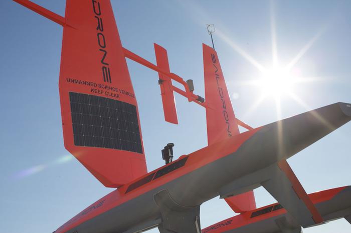
The 20-foot 'wing', or sail, of the drones has been developed over a 10-year period by Saildrone's founder, British engineer Richard Jenkins.
It is similar to the design used on the Greenbird, the vehicle Jenkins piloted to break the world land speed record for a wind-powered vehicle in 2009.
He reached a speed of 202.9 km/h on the dry plains of Ivanpah Lake in Nevada, a record that still stands today.
Jenkins began to apply the wing design to a sea-going vessel in 2012. The company's vessels have covered more than 60,000 nautical miles.

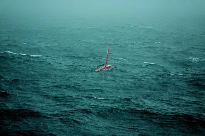
 Saildrone in stormy Bering Sea

"The Saildrone works with a combination of wind and solar using this unique patented wing. We harness the wind energy to push the vehicle along and then we use solar to charge the batteries and that runs the computers on board. So it doesn't consume anything while it goes along and so it can stay at sea almost indefinitely," Jenkins said.
"Autonomy is a key technology for accessing the southern oceans, which are understudied due to the rough seas and the limited number of vessels that regularly pass through the region," he added.

Salty sea bots

The Saildrones join a growing number of unmanned vessels monitoring Australia's surrounding waters.

The Saildrones are expected to launch in March.

In October, the Australian Institute of Marine Science (AIMS), completed a seven-day, 200 nautical mile trial voyage of its Wave Glider 'surfing robot'.
The vessel is the first of a number of technologies being put to work on the Great Barrier Reef by AIMS, the result of a five-year joint research agreement with aerospace giant Boeing.
Work is also underway to investigate the use of medium-range unmanned aerial systems equipped with hyperspectral cameras to collect high-quality imagery for seabed habitat mapping, modelling and classification, reef monitoring, and potentially 3-D reef reconstructions.

CSIRO operates a number of Autonomous Underwater Vehicles (AUVs), like the Starbug X which was built by engineers at its Hobart base.

The organisation also uses a number of robotic Argo floats, which drift at a one to two kilometre depth for ten days before ascending to the surface measuring temperature and salinity as they rise. The data is then transmitted to satellites, before the float dives and starts a new cycle.

Links :

Wednesday, January 24, 2018

The Agency that helped create the Internet now wants to wire the Ocean

DARPA promulgates vision of sensor-based "Ocean of Things"
aiming to to gauge the Seven Seas

From NewsDeeply by Paul Tullis

DARPA, the U.S. military’s R&D arm, is seeking proposals to deploy as many as 50,000 low-cost sensors across the ocean to gather data on marine conditions, but scientists say that the plan poses a significant technological challenge.

The Defense Advanced Research Projects Agency has had a hand in some of the most transformational innovations of the last half-century, including the computer network that evolved into the internet, the graphical user interface and passive radar.
Now DARPA is seeking proposals for what could be the next big thing: a network of intelligent floats “to enable persistent maritime situational awareness over large ocean areas.”

 Artist's cocept of DARPA's Ocean of Things programme.
“We plan to create floating sensor networks that significantly expand maritime awareness at a fraction of the cost of current approaches.” 
Credit : DARPA Agency

In other words, the “Ocean of Things,” as the agency describes the initiative.
It’s the marine version of the terrestrial “Internet of Things” – networked devices that communicate information about themselves to their users and to other devices, such as the Nest thermostat, which allows remote control of a house’s heating and air conditioning system, or a refrigerator that tells you when you’re out of milk.
“Head out to most parts of the open ocean, however, and no such capability exists for real-time monitoring of maritime activity,” DARPA noted in a statement.

Each float could collect environmental data such as water temperature, salinity, sea state and location, and detect the presence of vessels and marine mammals, transmitting the information via satellite.
Separately, private companies or academic institutions would develop data analytics software to process and make sense of all those bits.

The infrastructure of the Digital Ocean.
(Courtesy of Liquid Robotics, a Boeing Company)

“It’s great to see someone putting money behind this – particularly DARPA,” said Roger Hine, cofounder and chief technical officer of Liquid Robotics, a Silicon Valley company owned by Boeing that manufactures a self-propelled autonomous robot called the WaveGlider.
Liquid Robotics has proposed a “Digital Ocean” to integrate and connect devices and systems underwater, on the surface and onshore to expand understanding of the two-thirds of the planet that consists of the ocean.
“I’m really excited to see this happen,” Hine added.

The scientific case for collecting the information the Ocean of Things seeks is clear, said Jules Jaffe, a professor at Scripps institution of Oceanography at University of California, San Diego.
Jaffe designed a small swarm of underwater robots as well as the underwater imaging system used to find the Titanic.
Without a clear commercial marketplace, the private sector has lacked incentive to develop the devices and networks DARPA envisions.
“Government support is important,” he said.

 A NEMO float, part of the global Argo network of sensors, deployed in the Arctic. 
Courtesy of Argo

But Jaffe, Hine and others raised significant doubts about whether DARPA can achieve its program objectives within the constraints it has set.
The call for proposals limits the cost of the floats to $500 a piece, indicating DARPA will acquire 50,000 of them, and asks bidders to use materials “minimizing impact to the marine environment” with “biodegradable packing materials/floats” to the extent possible.

Hine pointed out that a battery sizeable enough to power such a device probably costs around $100, and the Iridium satellite modem DARPA requires is about another $100.
“It doesn’t leave a lot of budget for the actual sensing payload,” he said.

The agency listed salinity as a “potential” component of the suite of sensors, but Jaffe, who has decided not to participate in the DARPA program because “the bigger these [programs] get, the more of a pain in the ass they are,” said the least expensive device that does that costs $1,500.
With a more limited payload, though, “It’s not impossible” DARPA could acquire 50,000 intelligent floats for $500, he said.
“They’re challenging researchers to achieve aggressive goals.”

Another researcher with experience building underwater autonomous vehicles, who didn’t want to be named criticizing DARPA for fear of losing out on future funding opportunities, worries about the environmental impact of the program if it scales up.
Just 50,000 devices won’t provide much resolution of the ocean, so “scale is what makes it worth doing this research,” the researcher said.
“They have electronics, a battery on board. Putting more of them out there, I do worry about the environmental impact of these objects.”

Practical concerns are another obstacle to realizing an “Ocean of Things” as DARPA has defined it, this researcher said: “They’re going to find it really difficult to keep [individual floats] in place.
With a significant weather pattern, large- or small-scale eddies can create vortices so you end up with all the sensors in one location. Then you lose the resolution you’re hoping for.”

Hine agreed that eddies or drifting onshore are among the “significant limitations” to a float with no propulsion mechanism.
“It’s going to require a lot of engineering to make a dirt-cheap piece of electronics that actually does something useful,” he said.

John Waterston, DARPA program manager for Ocean of Things, told Oceans Deeply that, “DARPA is pushing to drive costs down on the individual floats, which is key to being able to deploy in large numbers.”
“With production rates of tens of thousands, DARPA expects that a sound business can be developed,” he added.
“We strongly believe that a well-designed float could be sufficiently modular as to be able to host a variety of sensors [which] can be switched out and usable for a variety of potential customers such as” the National Oceanic and Atmospheric Services, Department of Homeland Security “and even commercial organizations.”

If DARPA is successful, said Ryan Kastner, a UCSD professor of computer science and engineering who builds computer systems for oceangoing robots, “you’ll get an amazingly greater amount of spatial data than we have now – orders of magnitude more.” He estimated that a device that can do some of what the agency hopes would be possible in five to 10 years.
“DARPA can certainly push this sort of thing,” he said.

And that’s just what DARPA should be doing in this area, Hine maintained.
“Not all these questions should be answered at the beginning of a project like this,” he said.
“It’s good to be diving in and seeing where it takes you.”

Links :