
The Spotter’s sensors collect data on ocean conditions and beams the
information via satellite to scientists’ laptops and smartphones
Spoondrift
From NewsDeeply by Matthew O. Berger
Blue technologies being developed in the San Francisco Bay Area aim to give scientists and citizens low-cost tools to gather and share high-quality data on ocean conditions.
While waves that once a year become the monster swells ridden by surfers in the Mavericks surf contest roll toward the harbor of this small fishing town south of San Francisco, oceanographer Tim Janssen sits in an office a block from the sea with a handful of colleagues and two dogs.
They’re working on a small sensor-laden device he hopes to deploy by the thousands to gather data on those waves and other ocean conditions.
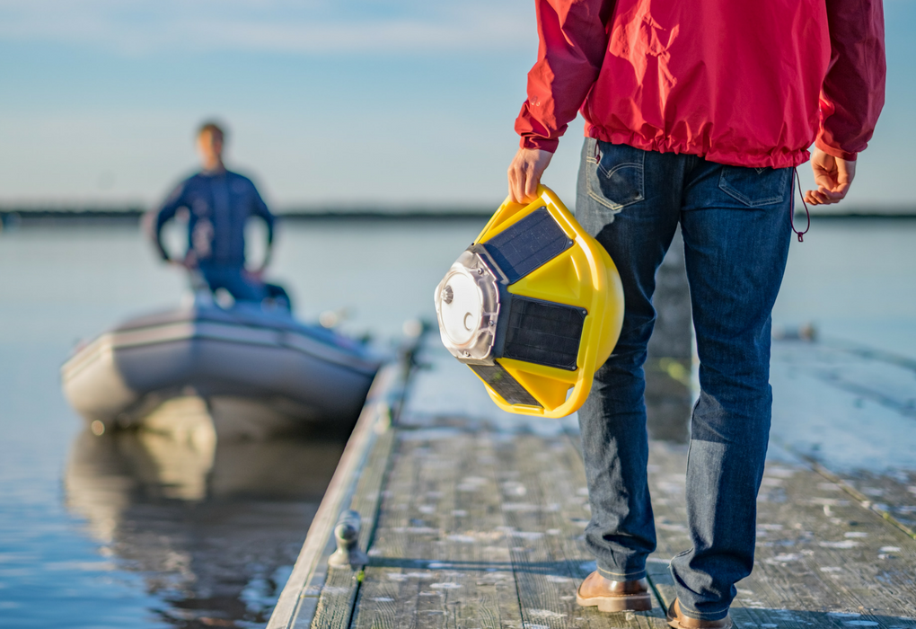
Called the Spotter, the yellow space capsule-shaped float is about the size of a beach ball.
Solar panels keep its batteries charged and the data gathered by its sensors is beamed via satellite to scientists’ laptops and smartphones.
“There’s no better time to have this tech revolution happen than right now,” says Douglas McCauley, a marine biologist at the University of California, Santa Barbara.
He also serves as a director of the Benioff Ocean Initiative, which aims to spur technological innovation to address ocean acidification, rising water temperatures, overfishing and other threats to the ocean.
The types of technologies being developed mirror terrestrial innovations – drones, autonomous vehicles, smartphones.
“Oceanographers, because of limited resources, have always tried to get by with less,” says Mark Schrope, program director of Schmidt Marine Technology Partners in San Francisco, which funds ocean technology startups.
“Whatever it is – ocean conservation, ocean data – there’s some technology on land that could really transform that area.”
The San Francisco Bay Area, home to a concentration of engineers, entrepreneurs and marine scientists, is emerging as a center of this new wave of blue technology.
On the other side of the peninsula from Silicon Valley, Janssen’s startup, Spoondrift, will start shipping its $6,000 Spotter this fall.
His ultimate vision is a constellation of data-gathering Spotters deployed across the ocean that send back a wealth of high-resolution information that can be analyzed in real time.
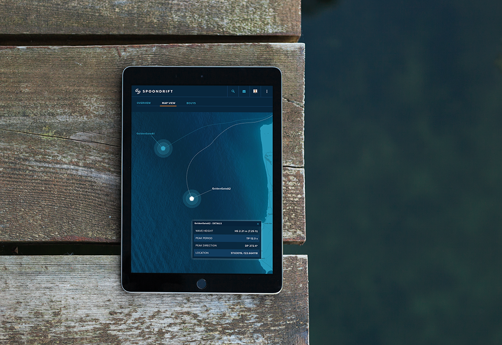
The current version of the Spotter gathers data on wave height, peak period, peak direction and location.
Janssen pulls up a map of a network of data-collecting buoys operated by the National Oceanic and Atmospheric Administration.
The red and yellow dots representing the buoys are clustered along the coasts.
But most of the open ocean remains a blue void.
Even closer to shore, a buoy may be the only one for miles collecting data on sea surface temperatures and wave activity.
Janssen, an oceanographer at San Francisco State University before starting Spoondrift in 2016, says marine scientists have “learned to live with very sparse data.”
“Everyone is building their own instruments but building them for themselves,” he says.
“We’re taking it one step further.”
More sensors would mean higher-resolution data on ocean acidification, surface temperatures and other marine conditions, showing how variables differ from one spot to another (or to tell you the exact conditions at your favorite surf breaks or fishing spots).
“If you want to find why, say, this coral is bleaching and that isn’t, you’ll need lots of sensors to be able to rule out temperature,” says Schrope.
Real time data access
Janssen brings up a map created by a fleet of sensors Spoondrift sent out from the mouth of the Columbia River in Oregon, a notoriously choppy and unpredictable patch of water to navigate and study.
They sent out so many sensors that the data collected was sufficiently high-resolution for the team to be able to recreate a simulated imageof what the waves looked like.
Making images like that isn’t in the company’s near-term plans as it is focused on obtaining high-resolution data that can yield a complete picture of ocean surface conditions.
Easy to use and deploy
Spoondrift says the Spotter costs about a tenth of the price of weather buoy and does not require a large vessel and winch to deploy it.
The 12lb (5.4kg) device can simply be picked up and dropped into the water.
McCauley notes that his research has been hobbled by a lack of high-quality data about what’s happening physically in the habitats he studies as the cost of sensors prevents their widespread deployment.
The vastness of the ocean – covering two-thirds of the planet – means that scientists need help from both new technologies and a growing legion of smartphone-wielding citizen scientists.
To try to determine the size of giant sea bass populations, McCauley has been tracking fish based on the unique markings each individual sports.
With the help of software, his team has reviewed thousands of photos of giant sea bass posted online by recreational divers, vacationers and whoever else shares photos of big fish.
“It’s about being able to leverage the power of people and our tendencies to post what we see,” he says.
OpenROV, a Berkeley, California startup funded by Schmidt Marine Technology Partners, hopes its technology will spur many more ocean images.
The company makes a tethered “underwater drone” that streams video of life under the sea to the operator’s smartphone or tablet, which is also used to control the device.
OpenROV’s newest model, the Trident, costs $1,500 and looks like a swimming Wi-Fi router with headlights.
It can venture to depths of 328ft (100m) and hits the market in August.

OpenROV’s newest underwater drone can venture to depths of 328ft (100m).
Cofounder David Lang was working at a sailing school when the urge to explore under the waves hit him. But he and his friends couldn’t afford a remotely operated vehicle (ROV).
“The technology had been around for a while, but it was expensive,” he says.
“So we started creating our own,” starting with a DIY kit and later a consumer product.
“But now we’re hearing from lots of people who actually need it,” adds Lang, including climate change researchers in Maine and biologists studying the foraging of minke whales.
A few years ago underwater videos like those taken with OpenROV’s drones would have only been affordable for a select few.
Today, they’re “within the reach of well-funded elementary schools and Girl Scouts who are really good at selling cookies,” McCauley says.
And more people taking and sharing underwater images would mean more data points for his research.
“If you think about engaging citizen scientists, you have to figure out what kind of data they would find interesting,” McCauley says.
“They’re not necessarily interested in salinity data, but are interested in photos and videos.”
These new exploration technologies are taking a range of forms.
A humanoid robot diver developed by a Stanford University team can spend more time at depths than would be safe for a human diver.
Autonomous ships are set to start sailing the seas in 2018.
Saildrone’s autonomous wind-powered mini-sailboats can be launched to collect a range of data.
A surfboard fin that contains a sensor leverages the amount of time surfers spend in the water to collect data on ocean salinity, pH, temperature and waves.
The wave-and-solar-powered Wave Glider made by Boeing’s Liquid Robotics can roam the world’s oceans for up to a year at a time collecting data on climate change and other conditions.
Kipp Shearman, a physical oceanographer at Oregon State University, has used the Wave Glider in his research, outfitting it with different sensors to monitor ocean-atmospheric interactions and deploying the surfboard-sized robot for long periods of time.
But he’s also noticed advances in more traditional technology.
Since 2006, he has used undersea gliders, autonomous missile-shaped capsules that can stay in the water for weeks, transmitting data back to shore.
In recent years, he’s seen onboard computing power increase, allowing the gliders to “fly” in more complex ways and avoid shipping lanes.
High-density lithium batteries now allow them to operate autonomously for about a year.
“It’s been a remarkable evolution in that technology over the last 10 years,” Shearman says.
“It’s getting us to the point where I think we’re going to see a lot more persistent observation out in the ocean.”
Shearman says his colleague Jonathan Nash recently showed him pictures taken at the base of glaciers, where it would be too dangerous to send a research ship.
Nash took the photos remotely with a motorized, autonomous kayak.
The challenge now is to make sure all this data is of sufficiently high quality to be useful and that there are adequate resources to process the information.
“If I’m out there collecting pH data with a pH sensor,” McCauley says, “I know exactly what went wrong” and can disregard suspect data or factor in margins of error or variance.
But that’s harder to do with a stream of crowd-sourced data from an array of sensors.
“If some of the sensors are good and some aren’t, for instance, that could be a real train wreck,” he says.
Care will also need to be taken to roll out the new technology in a way that doesn’t interfere with the environments it is studying.
“Drones are an amazing resource for learning about terrestrial wildlife, but if everyone has one they begin to disrupt the ecosystems they’re trying to study,” says McCauley.
“The oceans are big, but often smaller than we expect, at least the parts that we find interesting. But right now the problem is not sensor traffic.”
A nearer-term challenge is processing all the data that’s starting to come in.
“One of the great challenges now on the backend, on my side, is how to deal with that fire hose of data,” says McCauley.
“Data is only good if you can process it to get an answer out of it.”
Schrope sees a “ton of potential” to develop artificial intelligence to catalog and analyze ocean data and make it easily searchable.
That may be the next step in the blue tech revolution.
Links :
- National Geographic : 5 Ways Underwater Drones Are Helping Citizens Save the Ocean
- mag Drone : The Underwater Drone Market — Where Is It Going?
- T3 : Best underwater drones buying guide: determine which drone is right for you
- DeeperBlue : BIKI: Discover the World’s First Bionic Underwater Drone
- GeoGarage blog : Taking the digital revolution to sea: Ocean robotics at an ... / Wireless iBubble underwater drone will revolutionize the ... / OpenROV will change exploration of last true frontier / Liquid Robotics to usher era of smart oceans with ... / Liquid Robotics to launch wave gliders to collect ... / Liquid Robotics unveils Wave Glider SV3 ocean robot ... / Hundreds of floating robots could soon surveil the oceans / OpenROV Trident - An underwater drone for everyone / Brave robots are roaming the oceans for Science / No sailors needed: robot sailboats scour the oceans for ... / Stanford's humanoid diving robot takes on undersea ... / 12 robots that could make (or break) the oceans / The 'curious' robots searching for the ocean's secrets /
NewsDeeply : Network Effect: The Robots, Sensors and Satellites Digitizing the Ocean
ReplyDeleteWashingtonPost : Robot submarines could soon be used to spy on America’s enemies
ReplyDelete