Image credit: Getty Images
From BBC by Laura Trethewey (author of The Deepest Map: The High-Stakes Race to Chart the World’s Oceans -see GeoGarage blog-)
Many maps of the ocean floor are decades old.
The race is on to properly chart them by 2030 – and crowdsourcing could be part of the answer.
Tucked inside a federal government building in the American Rockies is the world's best collection of seafloor maps.
Occasionally a hard drive arrives in the mail, filled with new bathymetric – or seafloor – charts collected by survey vessels and research ships cruising the seas.
The world's largest public map of Earth's oceans grows just a little bit more.
Cloaked in ocean, the seafloor has resisted human exploration for centuries.
Folklore and myths told of it as the domain of terrifying sea monsters, gods, goddesses and lost underwater cities.
Victorian-era sailors believed that there was no ocean floor at all, just an infinite abyss where the bodies of drowned sailors came to rest in watery purgatory.
Throughout the last century, modern scientific techniques and sonar have dispelled the stories and revealed a little understood seascape of crusted brine lakes, steaming volcanoes, and vast undulating underwater plains.
We have only just begun to map, much less explore, this enormous subsea world.
The Victoiran era saw a massive effort to chart the world's oceans, but many areas have seen minimal mapping since
(Credit: Getty Images)
One organisation wants to change this – and quickly.
In 2023, Seabed 2030 announced that its latest map of the entire seafloor is nearly 25% complete.
The data to make the world's first publicly available map is stored at the International Hydrography Organization (IHO)'s Data Centre for Digital Bathymetry (DCDB) in a government building in Boulder, Colorado.

So far, the DCDB holds over 40 compressed terabytes of seafloor data.
The biggest contributor is the US academic fleet: 17 research vessels owned by American universities which constantly circle the globe studying the deep ocean.
Other contributors include the National Oceanic and Atmospheric Administration (NOAA) fleet, the Geological Survey of Ireland, and Germany's Federal Maritime and Hydrographic Agency.
The biggest users are scientists all over the world who rely on the data to conduct research.
Seabed 2030 has made extraordinary progress by asking countries and corporations to share maps with the DCDB.
But unfortunately, the map is not growing quickly enough.
Between 2016 and 2021, the map leapfrogged from 6% to 20%.
Since then, the pace has slowed.
In 2022, it reached just 23.3% complete; in 2023, 24.9%.
The ocean mappers came up with a new plan: crowdsourcing.
By attaching a data logger to a boat's echosounder, any vessel can build a simple map of the seafloor
"Crowdsourced bathymetry came about a few years ago when the IHO was saying: 'At this rate, we're never going to map the whole darn ocean; we need to start looking outside the box,'" says Jennifer Jencks, the director of the DCDB and the chair of a crowdsourced working group at the IHO.
By attaching a data logger to a boat's echosounder, any vessel can build a simple map of the seafloor.
This is crucial in developing coastal and island nations.
Tion Uriam, the head of the Hydrographic Unit at the Republic of Kiribati's Ministry of Communications, Transport and Tourism Development, recently received two data loggers that he's planning to install on local ferries.
"It's a win to be part of that initiative," he says.
"Just to put us on the map and raise our hands [to say] we want to be part of a global effort.
Our contribution might be small – but it's a contribution."
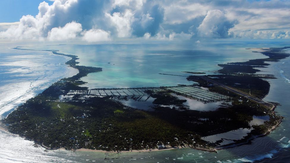
Kiribati is a Pacific island nation of about 130,000 people spread across 33 coral atolls, only 20 of which are inhabited.
British charts published in the 1950s and 1960s have been the most accurate maps to date; the United Kingdom and United States claimed various islands as protectorates or territories, mining them for phosphate or using them as whaling stations.
Other British maps used are old and inaccurate; some date back to the late Victorian age or list depth measurements in fathoms, which most countries moved on from years go (the US only retired it in 2022).
The biggest contributor is the US academic fleet: 17 research vessels owned by American universities which constantly circle the globe studying the deep ocean.
Other contributors include the National Oceanic and Atmospheric Administration (NOAA) fleet, the Geological Survey of Ireland, and Germany's Federal Maritime and Hydrographic Agency.
The biggest users are scientists all over the world who rely on the data to conduct research.
Seabed 2030 has made extraordinary progress by asking countries and corporations to share maps with the DCDB.
But unfortunately, the map is not growing quickly enough.
Between 2016 and 2021, the map leapfrogged from 6% to 20%.
Since then, the pace has slowed.
In 2022, it reached just 23.3% complete; in 2023, 24.9%.
The ocean mappers came up with a new plan: crowdsourcing.
By attaching a data logger to a boat's echosounder, any vessel can build a simple map of the seafloor
"Crowdsourced bathymetry came about a few years ago when the IHO was saying: 'At this rate, we're never going to map the whole darn ocean; we need to start looking outside the box,'" says Jennifer Jencks, the director of the DCDB and the chair of a crowdsourced working group at the IHO.
By attaching a data logger to a boat's echosounder, any vessel can build a simple map of the seafloor.
This is crucial in developing coastal and island nations.
Tion Uriam, the head of the Hydrographic Unit at the Republic of Kiribati's Ministry of Communications, Transport and Tourism Development, recently received two data loggers that he's planning to install on local ferries.
"It's a win to be part of that initiative," he says.
"Just to put us on the map and raise our hands [to say] we want to be part of a global effort.
Our contribution might be small – but it's a contribution."
Kiribati is a Pacific island nation of about 130,000 people spread across 33 coral atolls, only 20 of which are inhabited.
British charts published in the 1950s and 1960s have been the most accurate maps to date; the United Kingdom and United States claimed various islands as protectorates or territories, mining them for phosphate or using them as whaling stations.
Other British maps used are old and inaccurate; some date back to the late Victorian age or list depth measurements in fathoms, which most countries moved on from years go (the US only retired it in 2022).
(Credit: Getty Images)
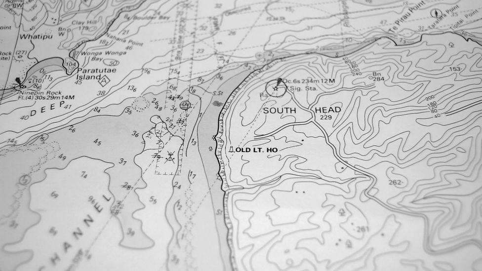
Kiribati's most accurate charts, made by the British, are nearly 70 years old

Kiribati in the GeoGaage platform (UKHO nautical raster chart)

Title : Kiritimati Atoll (Christmas Island)
United Kingdom
Scale : 90000 / Cat : 3 / Type : Coastal
Edition_date : 20150320 / Edition : 4
Update_date : 20220413 / Update : -
United Kingdom
Scale : 90000 / Cat : 3 / Type : Coastal
Edition_date : 20150320 / Edition : 4
Update_date : 20220413 / Update : -
That isn't so unusual in the Pacific, according to marine geologist Kevin Mackay, who oversees Seabed 2030's South and West Pacific Regional Centre at New Zealand's National Institute of Water and Atmospheric Research (Niwa) in the capital Wellington.
"The big problem in the Pacific is the relic of the colonial system.
So, in the Pacific, who looks after the mapping? It's the Americans through their territories, or the UK through their territories, or the French and their islands, even though they're now officially independent." Kiribati gained independence in 1979, but there's been little progress on surveying since then.
In 2020, the World Bank funded a $42m (£34.1m) project to improve maritime infrastructure in the outer islands.
A portion of that will go toward seabed mapping.
As one of the least developed countries in the world, most i-Kiribati (the name for Kiribati's inhabitants) live in the capital of South Tawara: a 17 sq km (6.5 sq mile) crescent-shaped atoll with a population density equal to Tokyo.
More people are crowding into the capital in search of a modern life, while the rest live on remote islands where poverty and unemployment is high, amenities are poor and the long-term future uncertain because of rising sea levels and severe tropical storms.
The military or commercial value of nautical charts will always be a barrier to achieving complete coverage of the world map
Improved charts could boost trade, transit and tourism on the outer islands.
They could help communities plan for tsunamis, storm surges and rising shorelines.
Many islands lack basic tide gauges, and so visiting ships time their arrival for high tide.
In his meetings with government ministers, Uriam tries to stress the economic benefits of improving nautical charts in Kiribati.
However, there's a roadblock when it comes to sharing maps with the DCDB archive back in Boulder.
Around a third of the IHO's 98 member states allow crowdsourcing inside territorial waters.
However, the Pacific island nations of Kiribati, the Independent State of Samoa and the Cook Islands, which all recently received data loggers from Seabed 2030, are not among them.
Until the governments give their blessing, the new crowdsourced maps will remain under wraps.
Despite Seabed 2030's publicly stated scientific goal, the military or commercial value of nautical charts will always be a barrier to achieving complete coverage of the world map.
"Sea charts, by their very nature, were destined to be removed from the academic realm and from general circulation," wrote the map historian Lloyd Brown in his book The Story of Maps.
"They were much more than an aid to navigation; they were in effect, the key to empire, the way to wealth."
In a world where only a quarter of the seafloor is charted, there's still an advantage in knowing more than your rivals.
Niwa's Mackay experienced this himself on a scientific-mapping expedition.
He received a call from a military he chooses not to name and "they said 'you need to destroy that data because there was military value in what you're mapping, because it's a place where submarines like to hide'," he recalls.
"Obviously, we ignore them because we're [mapping] for science, we don't care.
But the military, they find lots of value in bathymetry that, as a scientist, we don't even think about."
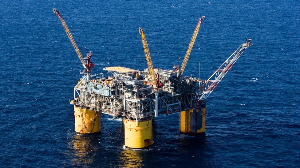
Accurate charts have made it much easier for countries to explot resource such as oil far out to sea (Credit: Getty Images)
For some nations, it's also suspicious that the DCDB is based in the United States, which has the world's most powerful military.
"We have seen concerns as well, that the DCDB is hosted by the United States.
Not everyone loves that," says Jencks.
She tries to assuage these concerns by stressing that the DCDB was endorsed by all IHO member states back when it was created in 1990.
In Kiribati, the challenges are less political, more practical, according to Uriam.
His position as the head of the Hydrographic Unit only became permanent about a year ago.
He used to work in the fisheries department and he knows just how hard is to share data across departments, let alone with outsiders.
There's also hurdles around storing data and hiring people with the right expertise to manage them.
Another concern: foreign research vessels have mapped some of Kiribati's territorial waters before and neglected to share data with the country's government.
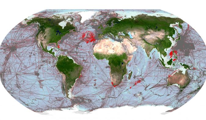
Image shows areas of the global seafloor that are considered mapped within the GEBCO grid. The regions coloured grey depict the coverage of mapped areas within the 2022 release of the GEBCO grid and the areas coloured red show the additional coverage included in the 2023 release.
(Image courtesy: The Nippon Foundation-GEBCO Seabed 2030 Global Center)
With just over six years left until the deadline, Seabed 2030 faces serious challenges in finishing the first public map of the seafloor.
The staggering size of the ocean, the depths, the hostile offshore working environment where ocean mappers are constantly contending with wind, waves, and the corrosive effects of salt water.
Then there's the cost of mapping remote international waters where no country has a responsibility to map.
However, all these challenges seem small compared to the work of uniting countries behind a collective goal, particularly ones as diverse as the US and the Republic of Kiribati.
The differences help explain why the goal of finishing a complete map of the seafloor may remain out of reach for many decades to come.
Links :
- BBC : The quest to map the mysteries of the ocean floor / The rush to claim an undersea mountain range
- Hydro : Pioneering ocean mapping for a better world
- NOAA : NOAA and International Hydrographic Organization Collaborate on Digital Bathymetry Data
- GeoGarage blog : NOAA announces launch of crowdsourced bathymetry database / smart ocean planning using crowdsourced data / Studying Arctic fjords with crowdsourced science and sailboats / Beta test of crowdsourced bathymetry holds promise for ... / The 15th-century monk who crowdsourced a map of ... / Mapping our ocean with the help of superyachts / One-fifth of Earth's ocean floor is now mapped / Citizen scientists to help map the reef
No comments:
Post a Comment